Ecobabble Reaches New Heights
Or lows, depending on your point of view
When is fragmentation just a mosaic? That nonsensical question is pertinent to the 2010 Draft Revised Revised Revised Revised Recovery Plan for the Northern Spotted Owl, which uses both terms depending on the mood of the authors.
Fragmentation is bad, very bad. Mosaics are good, very good. The fact that neither is defined and thus cannot be measured is handy, because for all intents and purposes they are the same thing.
But not to worry. The USFWS plans to model all that blarney sometime in the unforeseeable future. When they get a round tuit.
When they do, the USFWS modelers might find the following ecobabble useful, if “useful” means achieving total obfuscation without any connection to the real world.
Haydon, D. T. and E. R. Pianka. 1999. Metapopulation theory, landscape models, and species diversity. EcoScience 6: 316-328.
Abstract. We construct a model that describes the interaction of multiple metapopulation processes with measures of landscape patch diversity, fragmentary grain, and patch availability. Landscape models corresponding to Voronoi tessellations formulated around two-dimensional point processes are suggested as alternatives to conventional neutral landscape models. A method for creating the configuration of suitable habitat composed of multiple types of patches in randomized landscapes is suggested that utilizes perimeter polynomials associated with classical percolation theory. The landscape models are used to examine the influence of patch diversity, landscape grain, and total habitat availability on two measures of species performance that can be predicted from conventional metapopulation theory: the expected fraction of patches occupied by a species in the landscape (conditional prevalence), and the probability that a species will be represented in the landscape (representation). Results suggest that even when considering mutually non-interactive multiple metapopulation processes, the influence of landscape structure on species prevalence and representation depends in a complicated way on a combination of both species parameters and landscape parameters. Significantly, effects of changes in landscape structure on the distribution of a species cannot be anticipated from its pre-disturbance distribution. Our theory predicts that regional species diversity is maximized at intermediate levels of patch type diversity and fragmentation.
Keywords: Landscape models, multi-species metapopulations, habitat mosaics, Voronoi tessellations
Voronoi tessellations? From Wiki [here]
Definition
Let S be a set of points in Euclidean space with all limit points contained in S. For almost every point x in the Euclidean space, there is one point of S closest to x. The word “almost” is used to indicate exceptions where a point x may be equally close to two or more points of S.
If S contains only two points, a and b, then the set of all points equidistant from a and b is a hyperplane—an affine subspace of codimension 1. That hyperplane is the boundary between the set of all points closer to a than to b, and the set of all points closer to b than to a. It is the perpendicular bisector of the line segment from a to b.
In general, the set of all points closer to a point c of S than to any other point of S is the interior of a (in some cases unbounded) convex polytope called the Dirichlet domain or Voronoi cell for c. The set of such polytopes tessellates the whole space, and is the Voronoi tessellation corresponding to the set S. If the dimension of the space is only 2, then it is easy to draw pictures of Voronoi tessellations, and in that case they are sometimes called Voronoi diagrams.
Hang that on your Christmas tree.
Thanks and a tip of the hardhat to SOSF stalwart Alphonzo…
Climate and Weather Forestry education Politics and politicians
by admin
6 comments
Bundle Up For the Next Ten Million Years
The following science report came through the digital grapevine today:
Mummified forest offers glimpse of a warmer Arctic
Melting glaciers on Ellesmere Island reveal branches and trunks from millions of years ago, when the North was a temperate zone
By Randy Boswell, Postmedia News, Montreal Gazette, December 17, 2010 [here]
A research team probing a melting glacier near Canada’s northernmost point of land has discovered a “mummified” forest that’s at least two million years old, with “perfectly preserved” tree trunks, branches and leaves from a time when the Arctic was transforming from a temperate environment into the ecological ice box it’s been for millennia.
The present-day thaw at the north end of Ellesmere Island — another sign of the widespread warming now taking hold of Canada’s polar frontier — has served up intact spruce and birch trees believed to have been buried in a landslide during the Neogene period of Earth history between two million and eight million years ago.
The U.S. scientists studying the ancient forest, who say the liberation of the long-frozen relics will offer a unique window on a lost world, are also warning that pent-up carbon released from such sites across the Arctic could worsen the modern-day climate change being driven by human activity. … [more]
Reality check: The paleo boreotemperate forest (with boreotropical elements) was extant for ~100 million years, or as long as modern “trees” have been in existence. In fact, paleobotanists have to go back ~250 million years to the Permian-Triassic boundary to find conditions similar to today — it has only been for the last 2 million years that the Earth has been locked in a similar deep freeze.
Despite 250 million years of warmth, the seas did not boil away into outer space, life on Earth did not come to a screeching halt, the continents were not submerged, there were no searing deserts, and the atmosphere did not burst into flame.
That’s right, sports fans. Despite all the hysterical Thermageddon sky-is-burning raging paranoia trumpeted by mega-crooks and their bug-eyed dimwit followers, it turns out that a warmer Earth was a more abundant, diverse, life-giving planet. For hundreds of millions of years.
The scientists who made the discovery noted above found nothing that hasn’t been thoroughly investigated already. See: Late Cretaceous and Cenozoic History of North American Vegetation by Alan Graham (1999) Oxford Univ. Press.
But they did feel compelled to issue a WARNING. Hold on to your pants, the Earth might get warm again someday.
Probably not for 10 million years, though, which is time it is estimated that it will take for Antarctica to tectonically drift away from the South Pole. You see, the presence of a continent on a pole is what causes Snowball Earth.
All this is well-known to the researchers above, but they have to toe the party line, no matter how glaringly unscientific that party line might be, in order to keep their jobs as government-funded scientists.
Government-funding of science is killing science. Humanity gets stupider every day because politicians, the most knuckle-dragging throwbacks of our species, hold the purse strings of science.
Any gummit-funded science-schmuck who wants a steady paycheck has to totally bend, subvert, and/or deny his/her scientific findings until they match the Lunacy of the Overseers.
But so what? Who needs science anyway? Better to huddle, starving, in the cold and dark than to free the mind, explore Creation, and otherwise advance knowledge. Remain stupid, serve your masters, and keep your eyes, ears, and mouth shut. Reality bites. Be delusional. It is your feudal duty as a serf.
Forestry education Restoring cultural landscapes Saving Forests
by admin
1 comment
Machu Picchu of the Umpqua
by Mike Dubrasich, Exec Dir W.I.S.E.
Last summer intrepid researchers rediscovered an ancient Indian village perched on a recondite ridgetop in Oregon’s Cascade Mountains. Preliminary findings indicate that the site has been occupied for at least 3,000 years, or five times longer than the Incan sanctuary of Machu Picchu in Peru [here].
Now known as Huckleberry Lake, the ancient village was likely a summer residence for tribes from both the Umpqua and Rogue watersheds, including Molallan, Takelman, and Latgawan people, in recent precontact times (prior to ~1800).
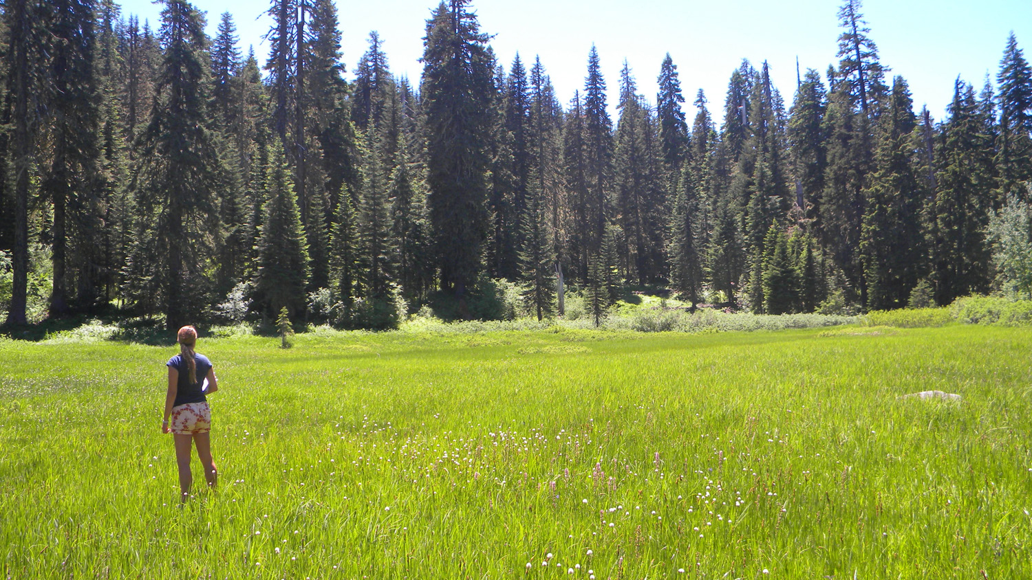
Huckleberry Lake in 2010. Click for larger image. Photo courtesy Bob Zybach, Oregon Websites and Watersheds Project, Inc.
Following leads from Chuck Jackson, elder of the Cow Creek Band of the Umpqua Tribe, landscape historians Dr. Bob Zybach and Nana Lapham located abundant evidence of ancient human use along the Rogue-Umpqua Divide in the vicinity of Huckleberry Lake. That evidence includes mortar and pestle rocks, obsidian debitage, food and fiber plants, and an ancient trail system, all consistent with oral histories of the Cow Creeks.
The Rogue-Umpqua Divide is a southwest tending spur of the north/south tending High Cascades that extends ~20 miles west of the Cascade Crest at elevations above 5,000 feet. Huckleberry Lake is on the westernmost point of the Rogue-Umpqua Divide, less than a day’s walk from known winter village sites near Tiller, OR.
Numerous springs that arise seemingly from the ridgetop are fed by lava tubes originating far to the east. They water small lakes perched above steep canyons that fall away to the north and south. Athough the vegetation today consists of dense true firs, remnant huckleberry fields (Vaccinium membranaceum) are evidence of a larger huckleberry complex that once carpeted the entire Divide [here].
Human tending with frequent anthropogenic fire must have been the principal factor that maintained the huckleberry brushfields, by excluding tree invasions. In the absence of such tending over the last 100 years or so, tree invasion has been extensive.
Dr Zybach stated:
There is very little history or other information available about the people who lived in the study area 200 years ago; however, much can be inferred from what is known of neighboring Tribes of that time, the presence and extent of current and historical vegetation patterns (particularly those of food and fiber plants), archaeological research, and known precontact travel and trade routes. Because people at that time did not have horses and because the South Umpqua headwaters are not navigable by canoe, travel was done by foot, along well-established ridgeline and streamside trail systems. Primary destinations would have been local village sites, seasonal campgrounds, peaks, waterfalls, the mouths of streams, and various crop locations, such as huckleberries, camas, and acorns.
Trail networks indicate where people went at certain times of the year, where they camped, and where they came from (or went to). Trails connect principal seasonal campgrounds, based on food harvesting and processing schedules, fishing and hunting opportunities, and trade. Freshwater springs at higher elevations were a critical element, such as Neil Spring near Huckleberry Lake.
Location and carbon dating of ancient home sites at Huckleberry Lake has yet to be done, but camas ovens in the area (with charcoal that has been carbon dated) indicate “intense and continuous [occupation] between 3,000 and 300 years ago” by Native Americans [here].
The research efforts are part of the South Umpqua Headwaters Precontact Reference Conditions Study, sponsored by Douglas County and supported by the Umpqua National Forest and the Cow Creek Band of the Umpqua Tribe.
Forestry education Restoring cultural landscapes Saving Forests
by admin
leave a comment
Four New Colloquia Posts
After a long hiatus (been working on a paper) we are pleased to announce the posting of four new works in our Colloquia:
Nataraja: India’s Cycle of Fire by Stephen J. Pyne may be found [here]. Dr. Pyne’s essay on the history of fire on the Indian subcontinent is a chapter from World Fire: The Culture of Fire on Earth (Pyne S.J., 1997, Univ of WA Press). He graciously sent it to W.I.S.E. as a companion piece to Roger Underwood’s Baden-Powell and Australian Bushfire Policy [Part 1 here, Part 2 here]. An extracted gem of a quote:
India’s biota, like Shiva, dances to their peculiar rhythm while fire turns the timeless wheel of the world. Perhaps nowhere else have the natural and the cultural parameters of fire converged so closely and so clearly. Human society and Indian biota resemble one other with uncanny fidelity. They share common origins, display a similar syncretism, organize themselves along related principles. Such has been their interaction over millennia that the geography of one reveals the geography of the other. The mosaic of peoples is interdependent with the mosaic of landscapes, not only as a reflection of those lands but as an active shaper of them (emphasis added). Indian geography is thus an expression of Indian history, but that history has a distinctive character, of which the nataraja is synecdoche, a timeless cycle that begins and ends with fire.
Stand Reconstruction and 200 Years of Forest Development on Selected Sites in the Upper South Umpqua Watershed, W.I.S.E. White Paper 2010-5 by yours truly (and the cause of the recent hiatus), examines the forest development pathways over the last 200 years in an Oregon Cascades watershed:
Several lines of evidence suggest that the prairies, savannas, and open forests have been persistent vegetation types in the Upper South Umpqua Watershed for the last few thousand years, at least. Precontact forest development pathways were mediated by frequent, purposeful, anthropogenic fires deliberately set by skilled practitioners, informed by long cultural experience and traditional ecological knowledge in order to achieve specific land management objectives. At a landscape scale the result was maintenance of an (ancient) anthropogenic mosaic of agro-ecological patches. In the absence, over the last 150 years, of purposeful anthropogenic fires, the anthropogenic mosaic has been invaded and obscured by (principally) Douglas-fir. As a result, the Upper South Umpqua Watershed is now at risk from a-historical, catastrophic stand-replacing fires.
In Pre-Columbian agricultural landscapes, ecosystem engineers, and self-organized patchiness in Amazonia by Doyle McKey, Stephen Rostain, Jose Iriarte, Bruno Glaser, Jago Jonathan Birk, Irene Holst, and Delphine Renard, the authors examine the manner in which arthropods and other critters have maintained nutrient-rich soils long after the pre-Columbian human residents created said soils:
Combining archeology, archeobotany, paleoecology, soil science, ecology, and aerial imagery, we show that pre-Columbian farmers of the Guianas coast constructed large raised-field complexes, growing on them crops including maize, manioc, and squash. Farmers created physical and biogeochemical heterogeneity in flat, marshy environments by constructing raised fields. When these fields were later abandoned, the mosaic of well-drained islands in the flooded matrix set in motion self-organizing processes driven by ecosystem engineers (ants, termites, earthworms, and woody plants) that occur preferentially on abandoned raised fields.
In The Columbian Encounter and the Little Ice Age: Abrupt Land Use Change, Fire, and Greenhouse Forcing by Robert A. Dull, Richard J. Nevle, William I. Woods, Dennis K. Bird, Shiri Avnery, and William M. Denevan, the (accomplished and distinguished) authors posit that Old World disease epidemics in the 1500’s eliminated anthropogenic fire along with the human population of Amazonia. The decline in human-driven carbon cycling was at a continental scale, and the reduction in emitted CO2 may have induced the Little Ice Age:
Pre-Columbian farmers of the Neotropical lowlands numbered an estimated 25 million by 1492, with at least 80 percent living within forest biomes. It is now well established that significant areas of Neotropical forests were cleared and burned to facilitate agricultural activities before the arrival of Europeans. Paleoecological and archaeological evidence shows that demographic pressure on forest resources—facilitated by anthropogenic burning—increased steadily throughout the Late Holocene, peaking when Europeans arrived in the late fifteenth century. The introduction of Old World diseases led to recurrent epidemics and resulted in an unprecedented population crash throughout the Neotropics. The rapid demographic collapse was mostly complete by 1650, by which time it is estimated that about 95 percent of all indigenous inhabitants of the region had perished. We review fire history records from throughout the Neotropical lowlands and report new high-resolution charcoal records and demographic estimates that together support the idea that the Neotropical lowlands went from being a net source of CO2 to the atmosphere before Columbus to a net carbon sink for several centuries following the Columbian encounter. We argue that the regrowth of Neotropical forests following the Columbian encounter led to terrestrial biospheric carbon sequestration on the order of 2 to 5 Pg C, thereby contributing to the well-documented decrease in atmospheric CO2 recorded in Antarctic ice cores from about 1500 through 1750, a trend previously attributed exclusively to decreases in solar irradiance and an increase in global volcanic activity. We conclude that the post-Columbian carbon sequestration event was a significant forcing mechanism.
It’s a hypothesis that is very difficult to test, but one that recognizes the historical impact of human beings on the environment. That theme permeates all four new Colloquia postings.
Our protocol with Colloquia postings is that comments there must be scholarly, commensurate with the scientific efforts of the authors. Less than scholarly comments on any of the postings are welcome, but should be placed here (see the leave a comment aplet below).
We endeavor to post the best, cutting-edge research papers, and all of these meet our stringent criteria. They are not too technical for the lay audience, though. I hope you enjoy them.
Forestry education Politics and politicians Private land policies
by admin
1 comment
Private Woodlands and the Statist JOF
by Travis Cork III
Note: Travis Cork is a South Carolina consulting forester and the author of The Fictional Ecosystem and the Pseudo-science of Ecosystem Management, W.I.S.E. White Paper No. 2010-3 [here] and The Market Illiteracy Embodied in the Politically Correct Version of Sustainability, W.I.S.E. White Paper No. 2010-4 [here].
The September issue of the Journal of Forestry has three op-eds regarding what’s happening “In and Outside of America’s Private Woodlands.” One might think that at least one of the op-eds would have an opinion from a private perspective, but all three are written from the statist perspective. The response by Fischer and Ruseva builds on the statist perspective of Messrs. Coufal, Wiedemann, and Greason.
The question is should the NIPF [non-industrial private forest landowner] be left to manage (or mismanage) his forest as he chooses, or should the state force its management choices on him.
Fischer, et al. write:
[The] ramification of “unregulated” timber harvesting as an ecologically harmful practice become even more salient once viewed through the prism of ecosystem services. As Coufal and colleagues acknowledge, “high-grading impacts all values of the forest.”
A legally-defined and enforceable framework of property and use rights that recognizes the public goods and CPR [common-pool resources] characteristics of forests can have important implications for the existing incentives to harvest. If WE [emphasis added] believe that private forests provide important ecosystem services enjoyed by society, then the need for [public] forester involvement in timber harvesting becomes a pertinent question.
It is discouraging and embarrassing to see the level of detachment from reality in the natural resource community. This community has taken a page out of Keynesian economics and sees the natural world in terms of simplistic aggregates, i.e., watersheds, ecosystems, biomes, etc. That the individual, whether it be man, animal, insect, plant, microbe, or any other form of living thing, is the basic unit of life is a fact that many in the natural resource community,especially in academia and bureaucracy, ferociously refuse to acknowledge.
The ecosystem concept is worse than a detachment from the reality of the natural world. It is a destructive device to justify the control-predictably by supposedly enlightened, superior humans-of inferior humans in their interactions with other individual organisms.
Federal forest policy Forestry education Saving Forests The 2010 Fire Season
by admin
11 comments
Some Let It Burn Questions Answered
Correspondent Zeke asked some pertinent questions regarding the Oak Flat Fire [here].
Dear Zeke,
Thank you for your questions. Here are the answers:
1. This fire could indeed have been contained at 800 acres. On Aug 15 the fire grew from 600 to 800 acres. On that date there were already nearly 500 firefighting personnel on the scene, 8 helicopters, and air tankers standing by in Medford.
The area is not “wilderness” or roadless. It is well-roaded throughout. No additional dozer work was necessary to contain the fire. There have been no strong winds so far, thank goodness, or the fire would have swept into Grants Pass within hours. Allowing the fire to grow and grow for weeks on end runs the risk that winds will arise and the fire will become a major disaster, burning farms, homes, towns, and cities. The USFS has chosen to endanger tens of thousands of residents, none of whom had any say so in the matter. That increased risk is manifest right now and will be for weeks to come.
2. It was and is possible to SAFELY put this fire out by ‘going direct’ on it. Indirect attack is LESS SAFE. Right now the “plan” is to put 1,000 firefighters a day for weeks on this fire. That is 10 to 20 times the man-hours necessary to contain it. By expanding the man-hours enormously, the risk of accidents increases.
Most firefighting injuries and fatalities are not due to burning up. They are due to machine accidents and fireline accidents, such as helicopter crashes and falling trees. The chance that those kind of accidents will occur is INCREASED by extending the fire for weeks and by extending the fire perimeter 10-fold.
3. There are no “benefits” to resources from wildfire. The USFS does not claim such. The use of the term “wildland fire used for resource benefit” is kaput. You can read the memo [here].
It is important to note that the deliberate use of fire produces significant impacts to the environment. We have laws regarding federal agencies impacting the environment, such as NEPA. If you read that law, you will note that “benefit” or “detriment” do not matter. What matters is whether the impacts are “significant”. No one argues that fire effects are insignificant.
Yet the USFS did not follow the legally mandated NEPA process before deciding to expand this fire ten-fold. They broke the law. That makes them criminals. Nobody wants federal agencies to break the law. I don’t at any rate. Do you?
For more discussion on this aspect, see [here, here, here, here].
4. Instead of looking at Google Earth, you may wish to examine the forest road map. That will show you the existing road density of the area. The road network is extensive. No new roads are needed, or new dozer lines, to contain this fire.
5. 6. 7. So you think that they could have held it to this footprint? Have you ever fought fire in that country? Are you an expert on wildfire tactics? Yes, Yes, Yes.
8. Is anything about that ground worth killing a single firefighter? Hold on there, Zeke. I am not for killing anybody. As I discussed above, extending the fire in time and space INCREASES the risks to firefighters.
In 2008 over 650,000 acres were incinerated in Northern California on the Shasta-Trinity, Six Rivers, and Klamath National Forests. The fires were allowed to burn vast tracts in accord with a revised fire policy the USFS called “Appropriate Management Response” (since then the USFS has dropped that lingo term, too). Building firelines miles away from the fires and backburning hundreds of thousands of acres of private and public land alike were deemed “appropriate.” Despite the remote firefighting techniques, ostensibly intended to save money and protect firefighters, over $400 million was spent on suppression and 12 firefighters were killed.
In 2009 direct attack was used on a fire in the same area. The Backbone Fire [here] was 6,100 acres in steep un-roaded country when the decision was made to use direct attack. The fire was 100% contained within a week at 6,324 acres, with no accidents and no fatalities.
So you see, Zeke, extending this fire is far more likely to result in death to firefighters than direct attack would have. Perhaps you should aim your “killing firefighters” question at the USFS instead of at me.
9. What do you hope to accomplish with your rant? My purpose, indeed the purpose of W.I.S.E., is to educate. The “rant” characterization is impolite on your part, but whatever the literary quality, my post caught your attention. And now I am educating you further. Please read (study) the links provided. You have much to learn, and we are here to aid you in that.
Thank you again for your questions. Please feel free to ask us such good questions anytime.
Sincerely,
Mike Dubrasich, Exec Dir W.I.S.E.
Climate and Weather Forestry education Politics and politicians
by admin
leave a comment
Bio Irony, Warmer Is Better Dept.
The new thing is biodiversity.
Globalists recognize the growing collapse of gloooobal waaaarming alarmism as a tool to advance One World Authoritarian government, so they have revived the U.N. Agenda 21 scare over allegedly declining biodiversity — to accomplish the same goal [here, here].
But, and here’s the irony, warmer climates have greater biodiversity. The warmer it is, the more biodiversity, and the cooler it is, the less.
Technically, biodiversity means the number of plant and animal species per unit area. In the tropics (warm climates) there are sometimes thousands of species per acre. In boreal and/or tundra regions (cold climates), there may be less than a dozen species per acre.
The definition is important. The U.N. defines “biodiversity” in a squishy fashion [here]:
Biodiversity is an all encompassing term to describe the variety of all life and natural processes on Earth.
The Convention on Biological Diversity defines biodiversity as “the variability among living organisms from all sources [...] this includes diversity within species, between species and of ecosystems” (Article 2, CBD).
But technically, biologists measure biodiversity using indices such as Simpson’s diversity index [here], the Shannon index [here], or species richness [here].
Those indices all express some variant of number of species per unit area. And measurements of biodiversity all indicate the same general condition: Equatorial latitudes have high biodiversity, and polar latitudes have low biodiversity (Antarctica has the lowest biodiversity on the planet).
A new study from Harvard hypothesizes that seasonality impacts biodiversity [here]. The authors note that during the Eocene (54.8-33.7 mya) [here], biodiversity was at its highest point in the history of the Earth. The authors conjecture that the onset of seasons, with wide temperature swings between summer and winter, were the primary cause of subsequent biodiversity loss.
But overall temperature appears to be a more important factor. Global temperatures reached their highest post-Cretaceous levels at about the Paleocene-Eocene transition, and they have been falling ever since. At least five major extinction events occurred in the Eocene alone:
The Lutetian-Bartonian event (41 mya)
The Bartonian-Priabonian event (37 mya)
The Late Priabonian event (35 mya)
The Terminal Eocene event (33.5 mya)
The Late Rupelian event (30.5 mya)
All these extinction events were associated with reductions in global temperature, thinning CO2, declining rainfall, and falling sea levels.
Seasonality has always been a phenomenon of our planet, and is due to the tilt of the Earth’s axis, also known as obliquity [here]. The tilt is nothing new. The Earth has been tilted for billions of years.
However, seasonality did become more pronounced as the Eocene gave way to the Oligocene (35.4-29.3 mya) [here] and even more so during the Miocene (29.3-6.7 mya). Then the Ices Ages ensued, and seasonality grew even stronger. But it was not the difference between the seasons that was so damaging to biodiversity — it was the fact that the climate across much of the globe dropped below freezing.
When the temperature is so cold that water turns to ice, life in general perishes. Living things are liquid water-based. We die if the water in our bodies turns to solid ice.
Some plants and animals have evolved defenses against sub-freezing temperatures, such as thick fur, internal body heat regulation, and dormancy. The Order of Mammals arose during the Eocene but really expanded as the climate grew colder. Deciduousness (winter dormancy in trees) also arose in the Eocene, first in response to six-month dark periods above the Arctic Circle. Trees that expressed winter dormancy migrated south during the Oligocene and Miocene, where their resilience to freezing conditions gave them competitive advantage.
The article about the Harvard paper states:
At the time [the Eocene] the McAbee fossils were created, Earth’s climate was far less seasonal at all latitudes, allowing tropical species, such as palm trees and crocodiles, to live in what is now the high Arctic.
But as must be obvious to everyone, lack of seasonality was not the thing that allowed crocodiles to bask under palm trees in the Arctic. Warmth was. Crocodiles and palm trees today live where seasons come and go, but they do not live where it’s cold.
The article continues:
When the Arctic was warm in the past, like the rest of the planet, it had a high degree of biodiversity, like the tropics do today.
That statement is more acceptable. Note that it says nothing about seasons.
When the earth was warmer than today, such as in the Eocene, Oligocene, and Miocene, there was much greater biodiversity.
If significant global warming occurs in the future (which is very doubtful), it will be good for biodiversity.
The U.N. is working at cross-purposes with itself. It wants to chill the planet but also wishes to increase biodiversity. Those are mutually exclusive goals.
The U.N. also desires One World Authoritarian government, but as must be obvious to everyone, One World Authoritarian government would not improve anything. We would still have nutzo leaders who work at cross-purposes with themselves, much to the detriment of humanity as well as to the environment.
One Worlders are not your friends. Nor are they friends of the environment. But that is restating the obvious.
No Trend In Southern Sierra Snowfall Since 1916
A recent study shows that snowfall in the southern Sierra Nevada has not trended up or down since snow measurements began in 1916.
The study is:
John R. Christy and Justin J. Hnilo. 2010. Changes in Snowfall in the Southern Sierra Nevada of California Since 1916. Energy & Environment, Vol. 21, No. 3, 2010
and the full text is [here]. A quote from the Conclusions:
With the available data from six mid-elevation stations in the Southern Sierra region of California we reconstructed annual snowfall totals for 36 missing years of the Huntington Lake record to complete the time series (1916–2009). The standard error of the missing years is calculated to be ±36 cm, or 6% of the 94-year annual mean of 624 cm in the most robust estimation method (though we utilized the average of six methods which reduces the standard error further.)
The results of both the annual and spring snowfall time series indicate no remarkable changes for the 1916–2009 period in the basins drained by the Merced, San Joaquin, Kings and Kaweah Rivers. In the six reconstructions the range of trend results varied only slightly from -0.3% to +0.6 % decade-1. With a consensus trend of only +0.5 cm (+0.08%) decade-1 ±13.1 cm decade-1 there is high confidence in the “no-significant-trend” result. The corroborating information on temperature trends (Christy et al. 2006), stream flow, precipitation and shorter period snow water equivalent trends presented here are consistent with “no-significant-trend” in So. Sierra snowfall near 2000m elevation since 1916.
Kudos to Christy and Hnilo. Well done.
I have, however, a great temptation to say “been there, done that.” In 2008 I did a study [here] of maximum winter snowpack in the Snake River watershed, which drains 108,000 square miles in parts of six U.S. states.
Christy and Hnilo examined the snowfall records for stations in the southern Sierras from Mariposa County in the north to Kern County in the south, a much smaller area.
They used six snotel stations that met “a minimal set of standards (consistent observations for at least 35 years)”. I used the 20 longest, continuously measured snotel records from 3 US Army Corps of Engineers databases containing 745 snotel records from the Snake River watershed. Of those 20 selected, the shortest record was 75 years long. I did not “reconstruct” any records.
But we found the same thing: no significant trend in snowpack or snowfall (not exactly the same things, but pretty close).
Christy and Hnilo got their researched published in a peer-reviewed journal. I did not even make the attempt, but instead self-published online at W.I.S.E. [here]. They probably got paid to do their research. I did not.
But none of that is important. What matters is that the information is finally coming out. No trend in snow.
Snow alarmists are requested to please stop ringing the alarm bells; there is nothing to get panicked about.
Taunting Ecologists
A few decades ago, in the dim and murky past, I attended the UC Forestry Summer Camp at Meadow Valley in the Sierras. All UC forestry students were required to spend 8 weeks taking intensive courses “in the field”. It was a wonderful experience where professors and students forged bonds, and we all absorbed heaping piles of forestry education.
The Camp had (still has) cabins, a mess hall, and some lecture rooms. My term included some 90 students. The Teaching Assistants would call us to class and meals with a battery-operated megaphone, which was necessary due to the size of the student body and our dispersed living arrangements. Still, the megaphone message system was annoying, being somewhat reminiscent of boot camp or a prisoner-of-war facility.
One evening a student (Fred P.) stole the megaphone from a TA (Ron W.). Fred then took off into the woods and began taunting Ron, using the megaphone with volume at full blast.
“Zere vil be no escapes.” “You are under our control.” “Ve have ways of bending you our vil.” “Ha ha ha ha ha!” Etc.
Fred was an athletic guy, a college gymnast, and quick. Ron was a little bit portly even then, and he couldn’t catch him. Fred played with that megaphone for hours. He darted around in the woods from one side of the camp to the other, hooting at Ron, who gamely tried to catch him, with no success. It was a delightful show.
I was reminded of this incident by an old friend and erstwhile Summer Camp historian, who sent me the following news clipping:
Ecologists shun the urban jungle
Only one in six papers tackles inhabited areas
by Zoë Corbyn, Nature.com, 16 July 2010 [here]
The world’s top ecologists are failing to study the landscapes that most need work, and they risk delaying conservation efforts and making their subject irrelevant.
That is the stark message from US researchers who have quantified the extent to which ecologists devote themselves to pristine wilderness at the expense of inhabited regions. The bias is a major problem for both the field and the environment, they say, because it is areas used by humans — which take up most of the Earth’s land-mass — that are in most need of conservation.
The researchers will present their work at next month’s Ecological Society of America meeting in Pittsburgh, Pennsylvania.
“Right now our backyards are black boxes,” says Laura Martin, an ecology graduate student at Cornell University in Ithaca, New York, who was inspired to pursue the analysis after she read a feature published in Nature last year (see ‘Ecology: Ragamuffin Earth’). “There are suburbs, villages and agricultural lands that are being completely left out of the picture as far as ecological processes go,” she says. The tendency to gravitate towards the wilderness for fieldwork has long been recognized among ecologists, but has never before been quantified.
Martin and her colleagues reviewed each of the 8,040 papers that had been published in the top ten ecology journals worldwide over the last five years, homing in on the 2,573 studies that were conducted on land and categorizing them according to the authors’ descriptions of the sites examined.
They found that in only around one in six papers had the ecologists deliberately set out to study regions used by humans. …
The article perhaps inadvertently reveals a sad truth: ecologists in general are clueless regarding ecosystems. It’s not just that currently inhabited regions are not studied; it is that so-called “pristine wilderness” doesn’t exist!
No (terrestrial) locale studied by modern ecologists has been “uninhabited” over the last 10,000+ years. Human beings have lived everywhere and had significant impact and influence on plant and animal distributions and populations. People have been a key component of ecosystems for millennia. We have not been remote from nature — we have been an integral part of it.
Ecologists are blundering into study areas with blinders on. They seek to study “pristine” nature without human influence, a condition which does not exist and has not existed for the longest time. Ecologists have no idea what they’re looking at, and no idea how to look at it. They are trapped in a bubble (of their own making) where they contemplate illusion, not reality.
What fools!
The notion behind SOS Forests is to emulate Fred. We have a bully megaphone and we taunt the fools at full volume.
“Everything you know is wrong.” “You couldn’t find your backsides in a snowstorm.” “Ecologists have their heads buried in sand.” Etc.
We owe it all to Fred. He showed us the way.
And a tip of the hardhat to Al for spurring the recollections.
Federal forest policy Forestry education Politics and politicians Restoring cultural landscapes Saving Forests The 2009 Fire Season
by admin
1 comment
Douglas Co. Commissioner Joe Laurance July 15 Testimony
Today the House Subcommittee on National Parks, Forests and Public Lands held an Oversight Hearing on “Locally Grown: Creating Rural Jobs with America’s Public Lands”. Among the testimonies [here] was that of Joseph Laurance, County Commissioner, Douglas County, Oregon.
Commissioner Laurance brought up many important points, not the least of which is that that our national forests today are unnaturally loaded with fuels. Over 110 million acres are in Fire Regime Condition Class 2 and 3, the most hazardous conditions.
The safest condition is FRCC 1, of which there are 60 to million acres. Commissioner Laurance noted that FRCC 1 closely approximates the natural, historic conditions “characteristic of the ‘anthropogenic’ forest in the year 1800, immediately prior to the European American presence.”
The following is the full text of his remarks, with complementary photographs:
Testimony of Joseph Laurance, County Commissioner, Douglas County, Oregon before the House Natural Resources Committee, Subcommittee on National Parks, Forests and Public Lands, July 15, 2010.
Distinguished members of the committee,
At a meeting of Oregon county commissioners last summer, I complained to my colleagues that while endless debate continued in congress about how federal forests should be managed, fires were ravaging federal timberlands in my county and throughout the western United States. The worldwide financial crisis that was draining the national treasury made re-authorization of “Secure Rural Schools” funding seem doubtful, threatening many of Oregon’s 36 counties with social and economic ruin. Bad news just kept coming with the word that unemployment in Douglas County had reached 16.4% and if unreported joblessness was considered, was probably greater than the 19% experienced here during the height of the “Great Depression”.
Talks were ongoing in Copenhagen about greenhouse gas emissions while the three fires in my county burned toward an eventual total of 20,000 acres, equal to the greenhouse gasses emitted by one million cars in a year’s time. My fellow commissioners suggested that I craft a solution to the problems you of this body are all too familiar with. The resultant resolution* has been carefully considered by commissioners from across the western United States who helped in its preparation. It has been unanimously adopted by the Association of Oregon Counties, Western Interstate Region of Counties, and the National Association of Counties (NACo) Public Lands Committee and is expected to be adopted by NACo at its annual national conference next week.
Twenty years and twenty days ago the Northern Spotted Owl was listed as threatened under the federal “Endangered Species Act”. It was then thought that loss of old growth habitat through logging was the culprit causing a declining population. In response, federal timber harvests were vastly curtailed. The Umpqua National Forest in my county saw an annual harvest of 397 million board feet in 1988 reduced to 4 million board feet in 2002. In the years since a policy of “benevolent neglect” of federal lands has seen Spotted Owl numbers continue to decline through habitat destruction caused by increasingly numerous and intense forest fires and through predation by the Barred Owl which favors this new “unmanaged” forest habitat. Federal policy, which had been multiple use of the forest with an emphasis on industrial harvest, sought a new strategy which has yet to be formulated in all these intervening years.
The resolution presented you provides that needed new strategy, not only for Oregon but for all of our nation’s federal forests from Appalachia to Alaska. Federal forest managers would now have a clearly defined desired forest condition that must be obtained within a specified time. If this becomes the “Intent of Congress”, the Forest Service and BLM would join with private industry to restore forest health and rural economies without drawing on the national treasury.
Federal forest policy Forestry education Restoring cultural landscapes Saving Forests
by admin
1 comment
The New Approach to Forest Stewardship
An encouraging Guest Editorial appeared in the Dead Tree Press yesterday, written by Tom Partin, president of the American Forest Resource Council:
Beyond the spotted owl: It’s time for a new approach in our federal forests
By Tom Partin, Guest Columnist, the Oregonian, July 08, 2010 [here]
The Oregonian’s recent article commemorating the 20th anniversary of the listing of the northern spotted owl on the endangered species list exposed the personal, largely hidden agendas of those who have advocated for the owl over the years. …
Now, after 20 years, it’s evident that slashing the harvest from our federal lands has not only made our forests into tinder boxes ready to ignite and burn the very habitat the owl needs, but has not kept the owl’s numbers from continuing to decline. By listening to the questionable wisdom of self-interested scientists whose livelihoods depend on grants to study the bird, we have come to a place where the owl is in far greater danger from fire and barred owls than from the boogeyman fall guy, logging. It’s time for a new approach.
Unfortunately, the new recovery plan for the spotted owl now under development by the U.S. Fish and Wildlife Service is unlikely to be that new approach. …
When are Oregonians and our society going to say enough is enough? Our state is on the brink of bankruptcy, unemployment is topping 20 percent in rural Oregon, county payments that are handouts in lieu of cutting timber will expire in 2012, and our forests are ready to burn. What we are doing and have been doing isn’t working. … [more]
We concur with Mr. Partin’s observation that what we have been doing isn’t working. Specifically, the The Northwest Forest Plan has been a catastrophic failure. The NWFP had (has) four fundamental goals. It has failed spectacularly to meet any of them.
1. The NWFP has failed to protect northern spotted owls
By most estimations, the northern spotted owl population has fallen 40 to 60 percent since inception of the NWFP.
2. The NWFP has failed to protect spotted owl habitat
Since inception, millions of acres of spotted owl habitat have been catastrophically incinerated. Millions more acres are poised to burn.
3. The NWFP has failed to preserve habitat continuity throughout the range of the northern spotted owl
The dozens of huge and catastrophic forest fires have left giant gaps in the range. The Biscuit Burn alone is 50 miles long and 20 miles wide.
4. The NWFP has failed to protect the regional economy
Since inception of the NWFP, Oregon has experienced 15 long years of the worst economy in the U.S., with the highest rates of unemployment, bankruptcy, home foreclosure, and hunger of any state. These are not just statistics, but indicators of real human suffering. Over 40,000 workers lost their jobs, and the rural economy has been crippled ever since.
The plan to save the owls has not saved anything; not owls, not old-growth, not the economy. The cost for nothing? $100,000 per job per year x 40,000 jobs x 17 years = $68 billion. That’s what Northwesterners have paid, for nothing. And the bills continue to mount.
Mr. Partin calls for a “new approach.” We concur. More significantly, here at W.I.S.E. we have laid out the strategy for that new approach: restoration forestry.
Restoration forestry is active management to bring back historical cultural landscapes, historical forest development pathways, and traditional ecological stewardship to achieve historical resiliency to fire and insects and to preclude and prevent a-historical catastrophic fires that decimate and destroy myriad resource values [here].
Those values include:
1. Heritage and history
2. Ecological functions including old-growth development
3. Fire resiliency and the reduction of catastrophic fires
4. Watershed functions
5. Wildlife habitat protection and enhancement (including spotted owl habitat)
6. Public health and safety
7. Jobs and the economy
Restoration forestry begins with the study and elucidation of forest history. Mr. Partin is correct in his assessment that establishment forest science has failed to provide the research and understanding needed. Forest history has not been a key component of establishment forest science in univesities and forest research centers.
Despite that deplorable state of affairs, in enclaves outside the Establishment a handful of intrepid forest scientists have been exploring forest histories. Their principal findings have been that human influences over thousands of years have played an enormous role in shaping our forests. Human influences — including frequent, seasonal, anthropogenic fire — provided the conditions whereby trees could reach old ages.
Human influences gave rise to our old-growth. That’s a stunning finding. It contradicts the old paradigm of forest development, which is based entirely on non-human factors. But the old paradigm is wrong. Too many anomalies exist in the real world, such as thickets of fir underneath ancient overstories of pine. The old paradigm cannot explain how natural forces alone created those (species-specific multicohort) forest conditions. The new paradigm, which accepts historical human influences as significant, does explain how our old-growth forests came to exist.
That’s an ecological issue. The old ecology is wrong. The new ecology is a vast improvement.
The Northwest Forest Plan is based on out-dated and incorrect assumptions about forest ecology. It is no wonder that the NWFP has failed; the scientists who crafted it were deficient in their understanding about how our forests developed.
Restoration forestry seeks to restore the actual, historical forest development pathways within the actual watersheds where that development took place. That is why restoration forestry stands a chance of succeeding where the NWFP and old paradigm ecology has failed so miserably and catastrophically.
We are encouraged by Mr. Partin’s call for a new approach, and in turn we encourage him to seek a greater understanding of what restoration forestry is, where its basis lies, and why it might succeed where the old approach has failed.
We encourage Mr. Partin, and all others, to review the papers in the W.I.S.E. Colloquia History of Western Landscapes [here], Restoration Forestry [here], Forest and Fire Sciences [here], and Wildlife Sciences [here].
Our Colloquia are works in progress. We have not gotten all the key papers up yet, but what we have posted so far should give readers a good introduction to new paradigm thinking.
We encourage Mr. Partin, and all others, to ask questions. That’s how learning occurs.
If more people begin to understand the new findings, the new ecology, and the new techniques of restoration forestry, then the “new approach” will become clearer. We won’t have to wonder what that new approach might be, nor be stuck any longer in the failed approaches of the past.
Forestry education Restoring cultural landscapes Saving Forests The 2010 Fire Season
by admin
leave a comment
Too Little, Too Late to Save Flagstaff’s Forests
An article about the Shultz Fire from Northern Arizona University:
NAU experts weigh in on lessons of Schultz Fire
Inside NAU, June 30, 2010 [here]
Expected to be fully contained today, the Schultz Fire [here] that scorched more than 15,000 acres in northeast Flagstaff and captured worldwide attention is human caused in more ways than one, said Northern Arizona University experts.
“This is a human caused fire from two perspectives,” said Daniel Laughlin, a research associate with the university’s Ecological Restoration Institute [here]. “A human campfire was left to burn in an ecosystem that became dense because of 100 years of mismanagement.”
A century of fire suppression has successfully kept fire off the peaks—a landscape dominated by ponderosa pine, which typically burn every two to 45 years. The blaze torched an area not burned since the 1890s in an ecosystem historically subject to frequent, low intensity fires.
There is a glaring misstatement in that.
Historically, the ecosystem was subject to frequent, seasonal anthropogenic fires. i.e. set by the indigenous residents.
I don’t know why ERI is so reticent to admit or even to investigate the historical forest development pathways in what is so clearly an ancient cultural landscape. It’s not like their host institution, Northern Arizona University, is equally deaf, dumb, and blind to the former inhabitants of the San Francisco Peak area (i.e. Flagstaff vicinity). See:
Dating Wupatki Pueblo: Tree Ring Evidence [here]
San Francisco Mt. Ware [here]
The Hopi’s, whose home mesas are east of Flagstaff, consider the San Francisco Peaks (Nuvatukya’ovi) to be sacred mountains. In fact, the Peaks are held sacred by over 13 Native American Nations [here].
The Tribes claim ownership and residency going back many hundreds of generations. There is no reason to doubt their veracity, since archaeological relics are frequent and widespread in the area. The Forest Service has identified the Peaks as a Traditional Cultural Property. It’s common knowledge that people have been living there for millennia.
It would be safe to assume that the native residents practiced landscape burning, since every other indigenous tribe in the Southwest (and elsewhere) burned their homelands regularly. And it is clear to many observers that frequent anthropogenic fire led to open, park-like forests and prairies. Putting those two well-known facts together leads to the inexorable conclusion that anthropogenic fire shaped the vegetation in the pine forests of Flagstaff.
More Geoglifo Photos
Geoglifos are ancient geometric earthen structures in Amazonia, built by civilizations that thrived hundreds and even thousands of years ago in what today is widely but incorrectly thought of as “wilderness”.
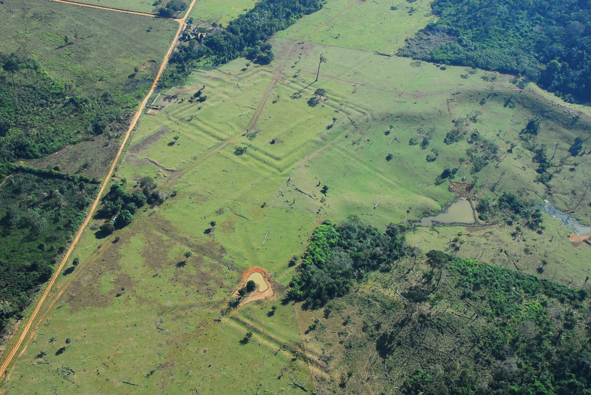
An example of geoglifos found in Acre, Amazonas, and Rondonia states. Photo courtesy Dr. William Woods. Click for larger image.
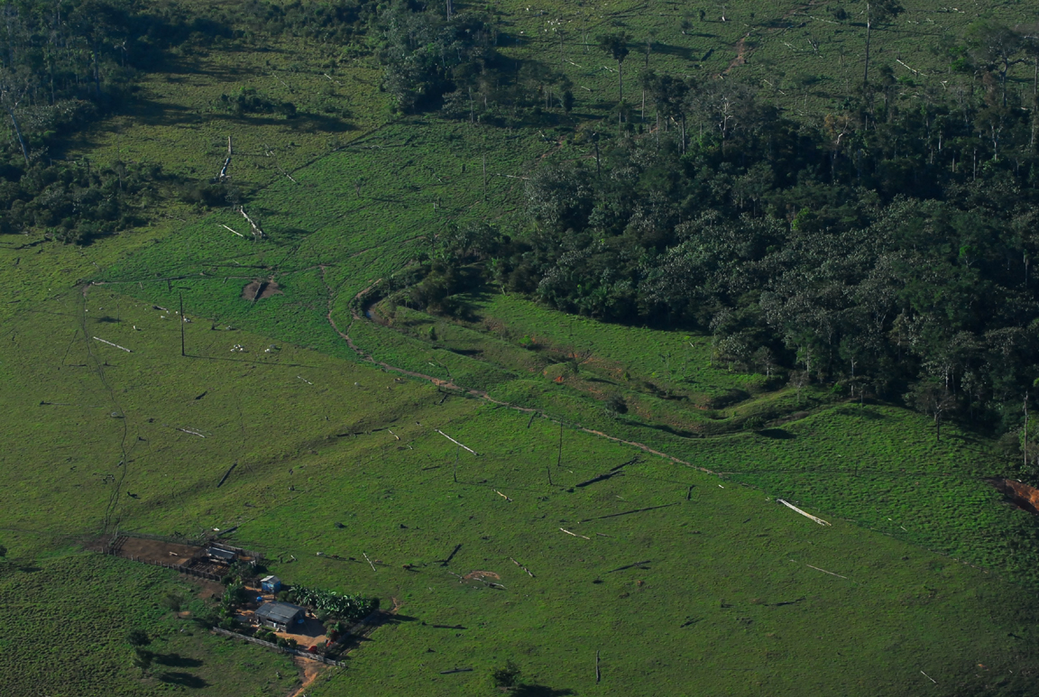
The clear implication is that the forest wasn’t there 500 years ago, but lots of people were! Many of the geoglifos are connected by kilometers of causeways or moat-like features. Photo courtesy Dr. William Woods. Click for larger image.
For additional photos, discussion, reports, and book reviews on pre-Columbian geometric earthworks in Amazonia see [here, here, here, here, here, here, here, here, here].
Climate Isn’t Responsible For Everything
World Climate Report [here] is World’s Longest Running Climate Change Blog. Much to the credit of its producers, WCR is an amazing source of excellent information on climate science. I highly recommend it. I am particularly interested in WCR articles related to forests, of which there are a goodly number.
There are many sub-issues that relate climate to forests, one of which is: how does climate change affect forest fires? Two articles at WCR on that topic are: Raining on Boreal Forest Fires, June 14, 2010, [here] and Wildfires: The Results of Cyclic Oceanic Variations or Global Warming?, March 27, 2007, [here].
The WRC reviews are reasonable, and fairly report the findings in the papers. However, both papers are flawed, as are so many others that deal with this particular question. The fundamental flaw that these papers share is a failure to consider two phenomena that are not related to climate (or weather) at all: biomass and human influences.
Biomass is the stuff that burns in forest fires. Biomass accumulation and continuity across the landscape are the principal factors in fire intensity and areal extent.
The chief human influence on forest fires has been ignition, deliberate and accidental, for millennia. Human beings are the only animal that makes fire, and we do so and have done so on every continent (save Antarctica) for the entire time we have been there. In the case of North and South America, for at least 13,500 years, the entire Holocene and part of the Pleistocene as well.
Forest fires occur in all climates, from tropical to boreal, wherever there are forests. They can occur in any season at any temperature, although inter-annual wet and dry cycles are key factors. Generally forest fires are less intense and smaller in wet seasons than dry. However, that is not always the case. What is always the case is that fuels (biomass) must be sufficient and continuous across the landscape for forest fires to occur.
What is also very often the case is that human beings lit the fire. The frequency, location, and season of fire is usually due to people, or hs been due to people in the past. Modern man is still a fire starter, but we also have developed fire suppression capabilities. So now we start and stop fires. It’s our choices both ways — the climate and climate change have little or nothing to do with it.
Those key factors, biomass and human ignition, overwhelm the influence of climate and certainly of climate change. That is, forest fires occur in every climate and during every climate cycle, and the key drivers (most significant explanatory variables) are biomass and people.
The papers cited above attempt to find climate phenomena as key variables in wildfire frequency and extent. Without going into detail, those findings are weakly supported by weak evidence, and the papers fail to even consider the actual key factors, biomass and people.
With all due respect to climate folks, they are barking up the wrong tree. There is an unhealthy tendency in climate science to look for, and find, climate to be a driver of all sorts of phenomena, from acne to prostitution. Some of those studies are laughable indeed. It just so happens that wildfire is another of those inferential stretches of climate science, but perhaps not so amusing.
One paper of interest on this topic is
Kay, Charles E. Are Lightning Fires Unnatural? A Comparison of Aboriginal and Lightning Ignition Rates in the United States. 2007. in R.E. Masters and K.E.M. Galley (eds.) Proceedings of the 23rd Tall Timbers Fire Ecology Conference: Fire in Grassland and Shrubland Ecosystems, pp 16-28. Tall Timbers Research Station, Tallahassee, FL. [here].
Dr. Kay found that,
[A]boriginal ignition rates were 270 to 35,000 times greater than known lightning ignition rates. Thus, lightning-caused fires may have been largely irrelevant for at least the last 10,000 years. Instead, the dominant ecological force likely has been aboriginal burning.
Oregon’s Forest Atlas 2010 online edition
Note: The Oregon Forest Atlas 2010 is online. Very interesting, very colorful maps. And some data to go along with them. Thanks to JG for the tip.
The Oregon Forest Atlas project [here] was developed in 2010 to provide public members with a broader understanding of Oregon’s forests using contemporary technology. Maps developed for the Forest Atlas use Geographic Information Systems (GIS) data obtained by the U.S. Forest Service PNW Research Station, data from Oregon State University and data gathered and maintained by the Oregon Department of Forestry.
Maps include:
MODIS Satellite Images of Oregon
Oregon Forestland Generalized Geology
Oregon Forestland Historic Vegetation - 1850
Oregon: Generalized Land Cover
Oregon Land Use
Oregon: Ecological Systems Habitat Types
Oregon Forestland - All Sources
Major Land Resource Areas
Oregon Forestland Site Productivity
Oregon Forestland Ownership
Oregon Forestland Management Classes
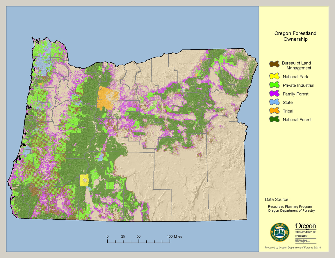
This map depicts Oregon’s forest coverage – 30,472,000 acres – expressed by whether the landowner is the federal government, State of Oregon, tribal governments, family/small woodland owners or private industrial timber producers. Data sources are the U.S. Forest Service PNW Research Station in Corvallis, the Oregon Institute for Natural Resources at Oregon State University and the Oregon Department of Forestry. Click for larger image. For full-sized image visit Oregon’s Forest Atlas 2010 online [here].
The Oregon Forest Atlas is intended to serve as an education and research tool to improve the understanding of public members regarding the attributes of among Oregon’s greatest natural resource assets, our forests.
Data for the Forest Atlas was compiled by staff with the Oregon Department of Forestry in 2010 using data generated by the U.S. Forest Service PNW Research Station in Corvallis, Oregon State University and the Oregon Department of Forestry.
The map products have been produced in the public domain by the State of Oregon. You may download, use, and copy the materials found within the Oregon Forest Atlas website for your personal, noncommercial or educational use, provided that all copies that you make of the material must bear data source attribution information for the material being copied.
This product is for informational purposes, and may not be suitable for legal, engineering or surveying purposes. This information or data is provided with the understanding that conclusions drawn from such information are the responsibility of the user.
Data contained within the map products does not necessarily reflect conditions at a fine-detail level. Some data models rely on site information at least one year old.
All information published herein is gathered from sources which are thought to be reliable, but the reader should not assume that the information is official or final, especially for the purposes of land use determination. The Oregon Department of Forestry does not assume responsibility for errors, and all research information contained within the website is subject to change without notice.
The materials within the Oregon Forest Atlas web site are provided to the public free of charge, “as is” without warranty of any kind, either expressed or implied, including, but not limited to, the implied warranties of merchantability, fitness for a particular purpose, or non-infringement.