Pre-Columbian geometric earthworks in the upper Pur’us: a complex society in western Amazonia
Martti Parssinen, Denise Schaan, and Alceu Ranzi. 2009. Pre-Columbian geometric earthworks in the upper Pur’us: a complex society in western Amazonia. Antiquity 83 (2009): 1084–1095
Full text [here]
Selected excerpts:
Abstract
It’s an ill wind that blows nobody any good. The combination of land cleared of its rainforest for grazing and satellite survey have revealed a sophisticated pre-Columbian monument-building society in the upper Amazon Basin on the east side of the Andes. This hitherto unknown people constructed earthworks of precise geometric plan connected by straight orthogonal roads. Introducing us to this new civilisation, the authors show that the ‘geoglyph culture’ stretches over a region more than 250km across, and exploits both the floodplains and the uplands. They also suggest that we have so far seen no more than a tenth of it.
Introduction
According to mid-twentieth-century neo-evolutionist interpretations of cultural development in the South American lowlands, pre-European Amazonian societies were mainly considered to be primitive egalitarian tribes living in small, impermanent villages in a hostile environment, unable to develop complex socio-political institutions (Steward 1948; Meggers 1954). Although historical accounts mentioned that floodplain river banks and islands were heavily populated by chiefdoms with village leaders and superior lords, some students of Amazonian archaeology and ethnology emphasised important differences between floodplain (varzea) and upland (terra firme) ecosystems. According to Lathrap’s model, for example, the varzea constantly attracted peoples due to its bountiful resources, especially aquatic fauna and good alluvial soils; but, as population pressure over limited land took its toll, they were forced to flee to the hinterland terra firme, where their cultural level decreased (Lathrap 1968, 1970). In her own way, Meggers (1991, 1995) also acknowledged higher levels of cultural complexity for varzea peoples, where some level of social hierarchy and elaborate material culture could develop, thanks to better soils. In her account, terra firme peoples remained demographically smaller and less complex, and were forced to live as hunters, collectors and semi-sedentary slash-and-burn cultivators. …
Roosevelt (1980), for her part, also had an important role in defending the varzea/terra firme dichotomy, emphasising the fact that the alluvial soils of the varzea were critical for supporting the indigenous development of chiefdoms, an idea not backed up by neo-evolutionist determinism, which always gave priority to outside cultural developments. …
As we can see, although scholars had different ideas on how to account for the differences between the two main Amazonian environments, the basic dichotomy between varzea (floodplain) and terra firme (interfluvial hinterland) remained valid for some time. In fact, given the scarcity of archaeological data for hinterland areas, researchers concentrated their efforts in trying to figure out how social complexity arose among floodplain societies (Carneiro 1970, 1987; Roosevelt 1993), accepting, even if not explicitly, that terra firme peoples had remained smaller and simpler.
In the flooded areas of the Amazon periphery – the Baures region of Bolivia, and on Maraj’o island, located at the estuary of the Amazon river (Figure 1) – Steward and Meggers supposed the undeniable signs of social complexity to have resulted from migration from the Andean highlands. Subsequent research has shown rather that social complexity developed indigenously, with the use of sophisticated landscape management techniques such as elevated terraces for agriculture and living, as well as dams and fishponds to manage aquatic fauna in order to guarantee the necessary protein intake (Denevan 1966; Erickson 1980, 2000; Roosevelt 1991; Schaan 2004, 2008). Since the late 1980s, researchers have found evidence of complex pre-European societies in Amazonian upland areas, such as in the Ecuadorian Amazon, where Porras (1987) and Salazar (1998) have found earthworks such as mounds and sunken plazas, and in the upper Xingu, where Heckenberger and his colleagues have described regional integrated systems, identified by villages with central plazas, as well as extensive landscape modifications with moats, roads and bridges (Heckenberger et al. 2003, 2008).
Adding to this debate, geometrically patterned anthropogenic earthworks, discovered since 1999 in both upland and varzea areas of western Amazonia, are among the most concrete proofs of versatile Amazonian cultures. Up to now, around 200 such sites have been found over an area that extends from northern Bolivia to the southern Amazonas state, encompassing the eastern part of the state of Acre (Parssinen et al. 2003; Ranzi 2003; Schaan et al. 2007) (Figure 2). The earthworks are shaped as perfect circles, rectangles and composite figures sculpted in the clay rich soils of Amazonia, and appear to be defensive and/or ceremonial enclosures, formed by excavated ditches and adjacent earthen walls.
Located for the most part on a 200m-high plateau, clusters of these monumental earthworks indicate a quite substantial population living in an area that scholars once believed to be an inadequate environment for sedentary settlement. Such sites indicate both the presence of complex societies capable of managing the environment, and the occurrence of larger populations in the uplands. Moreover, a recent discovery of the same type of sites in the Pur’us River floodplain, in the state of Amazonas, suggests that a floodplain versus upland dichotomy might no longer work as a variable for evaluating human adaptive behaviour in the lowland South American tropics.
Geometric earthworks in the uplands
The earthworks found in western Amazonia were named geoglyphs by Alceu Ranzi, the scholar who first saw them from an aircraft and realised they were built by pre-Columbian societies. Geoglyphs can be defined as marks on the surface of the earth, whose dimensions make them better seen from above. Indeed, regardless of the function that the excavated ditches and associated walls had in the past, their perfect geometry speaks of their symbolic significance.
The fact that the Amazonian geoglyphs have only been noticed and publicised in the last few years deserves an explanation. After their abandonment, which we believed happened at least 500 years ago, they were heavily covered by vegetation. In the last 30 years, however, areas once believed to be pristine forest began to be cleared for the cattle industry. In their new treeless, savanna-like landscape, the ancient earthen structures became visible, especially from the sky. If they were initially visible from aeroplanes, researchers can now search for them using satellite imagery freely available in Google Earth. Aerial remote sensing has in fact been more efficient than ground survey, since some structures are filled in by recent sedimentation, and thus hard to see at ground level. In fact, their enormous size makes it easier to distinguish their shape and configuration from an aerial perspective. Preliminary surveys in a number of sites have been done in several short field seasons.
In general, the geometric figures are formed by a ditch approximately 11m wide, currently 1-3m deep, with adjacent 0.5-1m high earthen banks, formed by deposition of the excavated soil. Ring ditches have diameters that vary from 90 to 300m. The circular structures are more common in the south, while composite and rectangular structures become more frequent as one moves north (see Figure 2). When there are two or more structures, they are usually connected by embanked roads. Some of the single rectangular structures may have short roads coming out of their mid-sides or corners. Composite figures include a rectangle inside a circle or vice versa. …
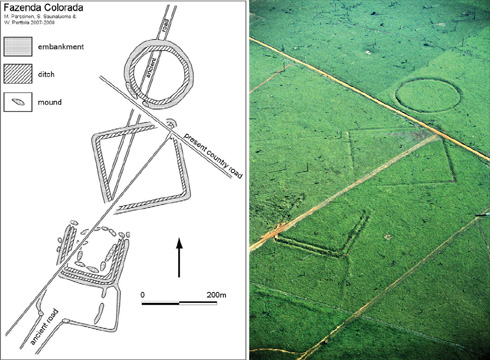
Figure 3. Aerial photograph and plan of the Fazenda Colorada site (photograph by Sanna Saunaluoma).
Date
Up to now, a single radiocarbon date is available for the Fazenda Colorada site in the Rio Branco area. It has been determined from a charcoal sample collected from an exposed profile of the three-sided square structure which had just been cut off by the rancher’s bulldozer when opening a dirt road. The sample was processed at the University of Helsinki, producing a date of 750+- 35 BP or AD 1244-1378 (c . AD 1283) in calibrated years (2s, sample Hela-616; Parssinen et al. 2003). We believe that this date is somehow representative of a number of sites, since this particular site exhibits much of the variability seen for the region. The date of AD 1283 implies a late occupation for such a site, only around 300 years before the Europeans’ arrival, but is consistent with the development of complex societies in other areas of the Amazon between AD 900 and 1400.
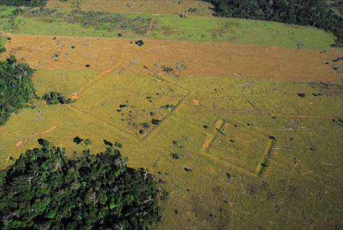
Figure 6. Aerial photograph and plan of the Fazenda Paran’a site (photograph by Edison Caetano, drawing by Martti Parssinen and Denise Schaan).
Discussion
In the pages above we present substantial evidence for a family of geometric earthworks (geoglyphs) that extend over a vast region drained by tributaries of the upper Pur’us River, one of the main tributaries of the Amazon. Composed of linear ditches that form geometric figures, bordered by walls and linked by walled roads, such earthworks indicate the presence of regionally organised societies, of the type that are commonly called chiefdoms (after Oberg 1955; see also Carneiro 1981). Although only one radiocarbon date is so far available, placing one of the most complex sites of the region in the first quarter of the second millennium AD, this is likely to be the period to which most of the sites should belong. Massive earthworks are found in other parts of Amazonia in the same time period, where complex societies arose over extensive areas of the Amazon River floodplain, estuary, savannas and a few upland areas, such as the upper Xingu and the Ecuadorian Amazon. The evidence for social complexity in the uplands of the Pur’us Basin, western Amazonia, not only adds data to this regional picture, but places all the existing data in a new perspective. Now it is more than clear that the terra firme was not an environment to preclude social complexity, but, in some settings, it even drew people to it. …
Whether the sites were purely ceremonial or defensive, it is clear that the area was densely populated by relatively sedentary people living both in varzea and terra firme environments at the eve of European contact. The 200 known sites, with over 210 geometric structures, are so far distributed over an area 250km across, encompassing both floodplain and terra firme environments. Given the poor coverage that Google Earth has for non-urban areas, we believe that the sites already found make up only 10 per cent of what is actually there.
We can anticipate the exploration of a substantial population purposely modifying, for centuries, environments that we once considered marginal. Although our research is still at an early stage, we feel that the theory of almost stagnant, ecologically determined cultural development as supposed by Steward (1948) andMeggers (1971), and the notion of drastic differences between varzea and terra firme cultures proposed by Lathrap (1970), can no longer be supported.