Oregon’s Forest Atlas 2010 online edition
Note: The Oregon Forest Atlas 2010 is online. Very interesting, very colorful maps. And some data to go along with them. Thanks to JG for the tip.
The Oregon Forest Atlas project [here] was developed in 2010 to provide public members with a broader understanding of Oregon’s forests using contemporary technology. Maps developed for the Forest Atlas use Geographic Information Systems (GIS) data obtained by the U.S. Forest Service PNW Research Station, data from Oregon State University and data gathered and maintained by the Oregon Department of Forestry.
Maps include:
MODIS Satellite Images of Oregon
Oregon Forestland Generalized Geology
Oregon Forestland Historic Vegetation - 1850
Oregon: Generalized Land Cover
Oregon Land Use
Oregon: Ecological Systems Habitat Types
Oregon Forestland - All Sources
Major Land Resource Areas
Oregon Forestland Site Productivity
Oregon Forestland Ownership
Oregon Forestland Management Classes
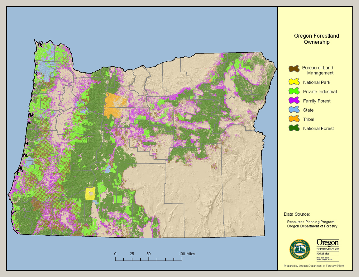
This map depicts Oregon’s forest coverage – 30,472,000 acres – expressed by whether the landowner is the federal government, State of Oregon, tribal governments, family/small woodland owners or private industrial timber producers. Data sources are the U.S. Forest Service PNW Research Station in Corvallis, the Oregon Institute for Natural Resources at Oregon State University and the Oregon Department of Forestry. Click for larger image. For full-sized image visit Oregon’s Forest Atlas 2010 online [here].
The Oregon Forest Atlas is intended to serve as an education and research tool to improve the understanding of public members regarding the attributes of among Oregon’s greatest natural resource assets, our forests.
Data for the Forest Atlas was compiled by staff with the Oregon Department of Forestry in 2010 using data generated by the U.S. Forest Service PNW Research Station in Corvallis, Oregon State University and the Oregon Department of Forestry.
The map products have been produced in the public domain by the State of Oregon. You may download, use, and copy the materials found within the Oregon Forest Atlas website for your personal, noncommercial or educational use, provided that all copies that you make of the material must bear data source attribution information for the material being copied.
This product is for informational purposes, and may not be suitable for legal, engineering or surveying purposes. This information or data is provided with the understanding that conclusions drawn from such information are the responsibility of the user.
Data contained within the map products does not necessarily reflect conditions at a fine-detail level. Some data models rely on site information at least one year old.
All information published herein is gathered from sources which are thought to be reliable, but the reader should not assume that the information is official or final, especially for the purposes of land use determination. The Oregon Department of Forestry does not assume responsibility for errors, and all research information contained within the website is subject to change without notice.
The materials within the Oregon Forest Atlas web site are provided to the public free of charge, “as is” without warranty of any kind, either expressed or implied, including, but not limited to, the implied warranties of merchantability, fitness for a particular purpose, or non-infringement.