Climate and Weather Federal forest policy Saving Forests The 2010 Fire Season
by admin
2 comments
Global Warming, Forest Fires, and SOS Forests
by Mike Dubrasich, Exec. Dir. W.I.S.E.
2010 the warmest year on record!
Or so the Warmistas claim. The drumbeat started back at least as far as last May [here]. And again in July [here]. And in September [here]. And in October [here]. And not surprisingly, this month [here, here, here, etc.] even though all year record cold waves pounded the U.S., Europe, Asia, South America, and Australia.
Let’s accept that premise for the moment. Boy, was it ever hot! Somewhere, not here, but somewhere.
Another premise that has gained huge air play is that forest fires are linked to global warming. It’s a no-brainer, right? It has been so hot that the woods catch fire and burn like there’s no tomorrow.
Or say the pundits. One paper that made a big splash and is cited in every USFS fire study, and every USFWS endangered species lawsuit, and has been anointed as canonical theology by all the High Priests of Ecology is:
A. L. Westerling, H. G. Hidalgo, D. R. Cayan, and T. W. Swetnam (2006) Warming and Earlier Spring Increase Western U.S. Forest Wildfire Activity. Science 18 August 2006:
Vol. 313 no. 5789 pp. 940-943 [here]
The authors state:
Here, we show that large wildfire activity increased suddenly and markedly in the mid-1980s, with higher large-wildfire frequency, longer wildfire durations, and longer wildfire seasons. The greatest increases occurred in mid-elevation, Northern Rockies forests, where land-use histories have relatively little effect on fire risks and are strongly associated with increased spring and summer temperatures and an earlier spring snowmelt.
Utah Wildfires As Seen from Space
by Robert Quigley, Geekosystem, September 22, 2010 [here]
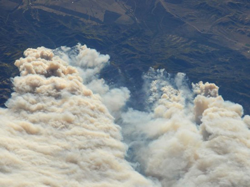
NASA has taken some remarkable pictures of Utah’s fires. Above, the Twitchell Canyon fire as photographed by the Expedition 24 crew aboard the International Space Station… [more]
Let It Burn Fire Updates
The Twitchell Canyon Let It Burn Fire [here, here, here, here] is now over 33,000 acres [38,644 acres as of 9/22]. Interstate 70 is open intermittantly. The power corridor that parallels the Interstate remains threatened and the power is off. Over 500 firefighters are battling the fire, which is reportedly 15% contained. Great Basin IMT2 (Whalen) has taken over fire management from Great Basin IMT2 (Ourada). Ten $million have been spent on “suppression” and “monitoring” to-date.
The Twitchell Canyon Fire has been burning since July 20th (two months ago). The stated purpose of allowing the fire to burn was “to manage the fire for a scenic vegetation mosaic effect”. High elevation mixed conifer forests and brush have been consumed. Extremely high fire intensities have been observed, with flame lengths over 200 feet.
The Sheep Let It Burn Fire [here, here] is now over 7,500 acres (3,078 acs Kings Canyon NP - 4,484 acs Sequoia NF). The fire crossed Lightning Creek on 9/13/10, and is showing approximately 150 to 400 acres of growth per day. Burnouts are underway on the south side of the fire.
The Sheep Fire has been burning since July 17th (over two months ago). The stated purpose of allowing the fire to burn was to achieve “ecological benefits of fire in the Sierra Nevada”. $1.2 million has been spent “monitoring” the fire which began in Kings Canyon National Park but spread to the Sequoia National Forest. Trails are closed. Air pollution has been extensive. Heritage giant sequoia groves are threatened.
Neither of these fires had any sort of NEPA process. No Environmental Impact Statements were prepared. No public review or collaboration was performed. Etc.
2007 Fire Season Federal forest policy Monkeywrenching forests The 2010 Fire Season Useless and Stupid
by admin
leave a comment
The Scenic Vegetation Mosaic Effect
The Fishlake NF offers a novel reason for their Twitchell Holocaust By Idiots Fire [here, here, here]. In numerous pronouncements the USFS claims their purpose in incinerating 20,000+ acres is:
“to manage the fire for a scenic vegetation mosaic effect”
Yup. It’s for the scenery — the old “Blackened Dead Forests Are Beautiful” campaign cooked up by the Wilderness Society on behalf of the Wildland Fire Leadership Council.
Just in case you don’t know what high severity fire does to the viewshed, here are some pics of other “successful” Let It Burn Because It’s So Lovely Projects inflicted on America courtesy your Helpful Federal Bureaucracy.
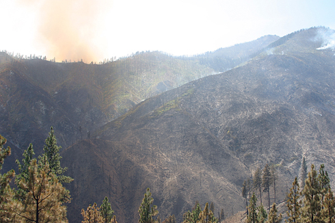
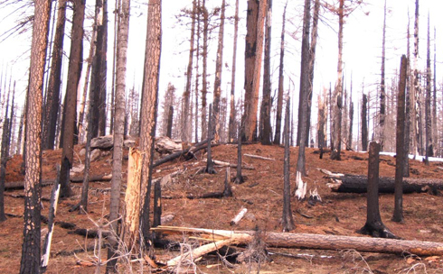
The esthetically pleasing aftermath of the 2007 Let It Burn fires in Central Idaho.
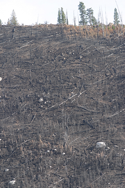
More of the same.
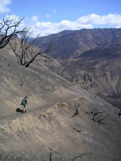
The beauteous Zaca Burn (2007, 240,000 acres, Los Padres NF).
Scenic splendor of the B&B Burn (2003, 90,000 acres, Deschutes NF).
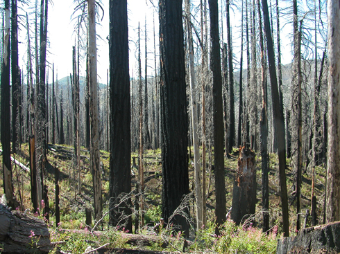
More of the same.
Evidently the USFS has adopted the position of Cascadia Summer, a Eugene “environmental” organization affiliated with Earth First! and the Oregon Natural Resource Council (now Cascadia Wild). In their own words [here]:
Last week [one week before the pictured B and B Fire was ignited] Cascadians paid a visit to the Clark Fire which burned 5,000 acres near Fall Creek earlier this summer. The area is still off-limits to the public, but we wanted to get a first-hand account of just how bad it was… so we quietly hiked in after crossing the stream a ways before the road-block.
The forest looked amazingly beautiful… stark contrast to the lush green forests we were used to seeing along Fall Creek, but beautiful nonetheless. Ferns had already begun sprouting back up through the ash. Scorched Doug Firs and cedars sparkled in the sunlight.
Yes, sports fans, the Federal Gummit wants to beautify your neighborhood and your watershed by turning it into a moonscape. It’s a stark contrast, but what the hey. The Scenic Vegetation Mosaic Effect is all the rage among the arsonist set, and it’s now the Official Mission of the USFS. Gaze in awe at your Gummit in action.
2007 Fire Season Monkeywrenching forests Politics and politicians The 2008 Fire Season The 2009 Fire Season The 2010 Fire Season
by admin
2 comments
Letter to the Salt Lake Tribune Re the Twitchell Canyon Fire
Dear Sirs and Madams,
Your reportage of the Twitchell Canyon Fire leaves out some important facts and context.
The Twitchell Canyon Let It Burn Fire has been burning on the Fishlake National Forest since July 20th [here].
It was declared a Let It Burn fire from the get go, without any NEPA process or public oversight. In the words of the USFS:
The fire is being managed for multiple objectives, which included providing for the safety of the public and firefighters, to increase structural diversity in forest and shrubland ecosystems through use of fire, reducing fuels in a mosaic pattern to effectively manage future fires, and to manage the fire for a scenic vegetation mosaic effect in the Manderfield Reservoir viewshed.
Get that? The “purpose” of this wildfire is to create a scenic “mosaic” of incinerated forest with “structural diversity”. Those are environmental “objectives” but without any sort of environmental analysis or EIS as required by law.
A barebones crew of 26 were assigned to “monitor” the fire. They watched while the fire grew and grew. By August 14th the fire had grown to 4,128 acres and a real fire crew was called in. Over 200 personnel fought the Twitchell Fire for a week, but then they went home. By August 26th the fire was 4,508 acres and a “monitoring” crew of 20 was all that were left. By that date $2.5 million had been spent to “achieve objectives”.
On Sept. 3 the Twitchell Fiasco Fire blew up to 5,400 acres. Two days later the fire was 7,000 acres and the Kimberly Mining District was evacuated. The Great Basin Type 2 Incident Management Team was been called in. $3.2 million had been spent on “suppression” by that date.
Again, no effort was made to contain the fire, but it settled down at around 11,000 acres on Sept. 7. For a week. Then on Sept. 14 it blew up again. As of last night the fire was over 20,000 acres and was impinging on I-70 and the adjacent power line corridor.
Over $6 million has been spent not suppressing this Let It Burn fire to-date. Aerial firefighting has been undertaken with the attendant ratcheting up of costs.
Rather than “creating a scenic mosaic” the fire has displayed flame lengths of over 200 feet. Historically high ERC’s (Energy Release Components, an index that measures fire intensity) have been recorded. This fire is burning VERY HOT. It is not a lazy or light “mosaic” burn. It is total incineration. Nothing is left alive withing the perimeter, animal or vegetable.
Numerous historical structures have been burned. More are threatened. I-70 has been closed. Smoke has poured to points east for two solid months.
The watershed being incinerated contains a number of reservoirs. $Millions are being spent to turn that watershed into a moonscape. Flash floods are sure to follow this winter. The government functionary directly responsible is Fishlake NF Supervisor Allen Rowley. No NEPA process was followed. This Let It Burn fire is patently illegal.
TBTB
Too busy to blog. Back soon. — Mike
PS — If you want to write an appropriate essay, go ahead. Send it in. I’ll post it.
PPS — Still tracking fires at WISE Fire Tracking. The Sick Twitch Fiasco Let It Burn Fire has blown up to 17,891 acres [here]. That’ll teach those Utahans a thing or three about complaining about the FEDERAL GOOBERMENT! Burn you whiners out!
Garbled Warming
USA Today today reports that the 2010 Fire Season has been a mild one, due to the weather, not “climate change” of course.
USA catches a break this year with mild wildfire season
Both in terms of total number of wildfires as well as acres burned, 2010 is the least active year of the past decade.
By Doyle Rice, USA TODAY, September 8, 2010 [here]
The USA is enjoying an unusually quiet year for wildfires, the least fiery of the past 10 years, according to data from the National Interagency Fire Center in Boise.
Both in terms of total number of wildfires as well as acres burned, 2010 is the least active year of the past decade.
Weather conditions have been ideal this year for a calm wildfire season, particularly in the fire-prone West.
“It’s been a combination of rain at the right time of year in the right place,” says Robyn Heffernan, assistant fire weather program manager of the fire center.
“The weakening of El Nino (and eventual transition to La Nina) brought abundant spring rain to the Northwest and kept a persistent West Coast trough of low pressure throughout the summer,” she adds. “This kept (wildfire) fuels moist in the Northwest quarter of the country into the summer fire season.
“It was the perfect combination for little fire activity in the lower 48.”
As of Sept. 3, 43,470 fires had burned in the USA, slightly less than the 45,152 that burned in 2003, according to the fire center. This amount is 71% of the average of 61,219 fires.
The total acres burned across the USA has been less than half of an average year. So far in 2010, 2.6 million acres have burned nationally; in a typical year, 5.7 million have been scorched, to date.
Also thanks to El Nino, the spring was very wet in the Southern tier of states, reports Heffernan, which is typically that region’s most active season.
“Last winter was under the influence of an El Nino, which gave the Southern tier of states moist conditions going into the spring fire season,” Heffernan says.
Many of the wildfires this year have been in Alaska. “They were busy in their peak of fire season, which is in June,” she adds.
Alaska burned around 150% of its normal number of fires and in excess of 200% of normal acreage.
“If you took those fires out, the lower 48 total would be significantly lower.” …
That’s not to say that there haven’t been devastating fires. Thousands of acres of spotted owl forests have been incinerated in various Let It Burn fires, and homes destroyed in numerous others.
Note: the worst of this year’s home-destroying wildfires is burning right now west of Boulder, CO. The Four Mile Canyon Fire [here] has burned more than 50 homes so far. The West Fire [here] and Bull Fire [here] in Kern County, CA burned 30+ residences in July. And the typical fall wildfire season in Southern California has not kicked in yet.
But the numbers don’t lie; this year has been a relatively mild fire season to-date.
The “conventional” wisdom has been that the globe is heating up like a frog in a microwave oven, though. The “models” are off the charts. Some “experts” like NASA’s James “Venus Syndrome” Hansen believe the seas are going to boil away into outer space if we don’t stop driving SUV’s [here].
It has been a popular alarmist refrain that early snowmelt and increased spring and summer temperatures have occurred and are driving increases in wildfire acreage. A single speculative paper is most often cited: Westerling, A.L.; Hidalgo, H.G.; Cayan, D.R.; Swetnam, T.W. 2006. Warming and earlier spring increase Western U.S. forest wildfire activity. Science, Vol. 313: 940-843 [here] for this dire report.
Of course, one unchallenged study using uncertainty-laden computer models does not equal truth. That hasn’t impeded AGW (anthropogenic global warming) alarmists from trumpeting it, however. The Draft Cohesive Strategy [here], for instance, was written by Westerling et al. true believers.
The problem with the alarmist theories is that the weather won’t cooperate with the climate models. Despite the overwhelming consensus of People Without a Clue [here, here, here, for instance], colder-than-usual weather keeps contradicting the Incredible Warming Models.
Even the President and Chief Alarmist Barky Obama had to concede last winter that Snowmageddon had arrived [here]. Al “Sex Poodle” Gore bought a mansion on the beach, indicating his money doesn’t go where his mouth does [here]. Record salmon runs have filled western rivers [here], in response to the PDO shift [here] to colder waters. And despite their best efforts, the Nation’s Interagency and Interdepartmental Wildland Fire Management Community has not been able to burn as many acres as they had hoped for. $Billions in FLAME Act funds are not getting spent, much to everyone’s chagrin.
Our cold, wet Spring and the Shortest Summer On Record have pretty much shot the Incredible Warming Models full of holes. Which was also predicted [here]. It’s that darn weather. It just won’t cooperate.
World Governments are doing all they can to raise taxes and inflict economy busting regulations, and they need evidence to justify their Luddititude. But the evidence keeps undermining the Alarmist wonkies. The seas won’t boil, the fires won’t burn, and the weather won’t do what the models tell it to do.
Everybody talks about the weather, but nobody seems to be able to make it do what they want.
But not to worry. The Lame Ducks will quack things up. Get out your check books, or sell your kids if you have to. The Largest Tax Hikes in History are coming. They’ll cure what ails the weather, or my name isn’t Quetzalcoatl.
Fire Follies on Labor Day
For all of you that don’t follow fires on W.I.S.E. Fire Tracking, here are some of the more egregious dis-competencies from the fire reports this morning.
The Twits on the Twitchell
Twitchell Canyon WFU Fire [here] has been burning on the Fishlake National Forest since July 20th. It was declared a Let It Burn fire from the get go, without any NEPA process or public oversight. In their own words:
The fire is being managed for multiple objectives, which included providing for the safety of the public and firefighters, to increase structural diversity in forest and shrubland ecosystems through use of fire, reducing fuels in a mosaic pattern to effectively manage future fires, and to manage the fire for a scenic vegetation mosaic effect in the Manderfield Reservoir viewshed.
Get that? The “purpose” of this wildfire is to create a scenic “mosaic” of incinerated forest with “structural diversity”. Those are environmental “objectives” but without any sort of environmental analysis or EIS as required by law.
A barebones crew of 26 were assigned to “monitor” the fire. They watched while the fire grew and grew. By August 14th the fire had grown to 4,128 acres and a real fire crew was called in. Over 200 personnel fought the Twitchell Fire for a week, but then they went home. By August 26th the fire was 4,508 acres and a “monitoring” crew of 20 was all that were left. By that date $2.5 million had been spent to “achieve objectives”.
Yesterday the Twitchell Fiasco Fire blew up to 7,000 acres. The Kimberly Mining District has been evacuated. Ourada’s Type 2 IMT has been called in. Hundreds of firefighters will “monitor” the out-of-control fire and spend more $millions ($3.2 million has been spent to-date).
Oh yes, the watershed being incinerated contains the Manderfield Reservoir 7 miles east of Manderfield, Utah. $Millions are been spent to turn that watershed into a moonscape. The genius behind all that is Fishlake NF Supervisor Allen Rowley.
The Bull S*** Fire
In mid-August a lightning storm swept across the Oregon Cascades. Numerous fires were ignited, among them some on the Mt. Hood NF near Olallie Lakes [here].
A local fire crew responded, but two weeks later (August 26th) they were withdrawn and the PNW Team 2 (Type 1 National IMT, Hoff) assumed command. The fires were over 3,000 acres combined on that date and $2.7 million had already been spent (unsuccessfully). One of the fires (Pyramid Butte Fire) had swept across the Pacific Crest Trail and was burning on the Warm Springs Reservation.
Fire crews ramped up to over 850 personnel and a $million per day was spent to contain some of the fires. By September 2nd 4,523 acres had burned and over $7 million had been spent. The fires near Olallie Lakes had been contained, but not those in the Bull of the Woods Wilderness.
The Bull of the Woods Wilderness is on the west side of the Cascades. It is 37,607 acres in size and contains low elevation old-growth spotted owl forests. It was designated in 1984 ostensibly to “protect” the old-growth and the owls. Of course, it is not really “wilderness” due to the fact that human beings have been residing there for approximately 10,000 years.
Because it is “designated wilderness” the fires there were not fought but allowed to burn unchecked. And burn they have. Of the 4,736 acres burned in the View Lake Fires, 2,871 have been the Bull of the Woods “wilderness”.
On September 3rd the Type 2 IMT was withdrawn and a special National Incident Management Organization (the Portland NIMO) has taken over. There is still zero firefighting going on in the Bull of the Woods although 660 firefighting personnel are doing something somewhere. Yesterday a firefighter was seriously injured by a falling rock. The Warm Springs Interagency Hotshot Crew member was transported to Legacy Emmanuel Medical Center in Portland where, this morning, he is reported in serious condition.
The PCT remains closed, as does the Bull of the Woods “wilderness” where spotted owls are exploding into balls of flame in mid-air and their old-growth habitat is being destroyed. The NIMO has informed the public that the fires will burn until the snow flies for all they care. MHNF Forest Supervisor Gary Larsen has cloaked himself in a cone of silence.
Meanwhile dingbat eco-freaks [here] have climbed into trees in Eugene to protest a timber sale on the Willamette NF. The Trapper Restoration Project has been in the planning and preparation phase for 12 years! After numerous appeals and court cases, it might be logged, but not if the eco-insane can stop it. They claim it is the last native forest in Oregon. No word on how they feel about the Bull S*** Fire incinerating thousands of acres of old-growth owl forests.
Oak Flat Follies
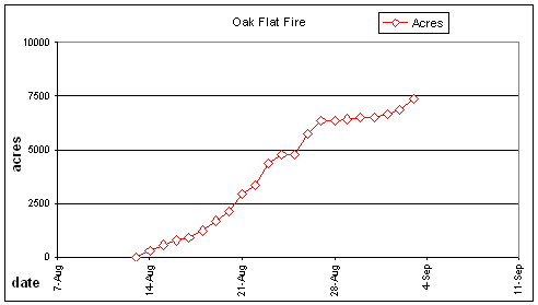
The Oak Flat Deliberate Forest Incineration continues [here, here, here, here]. Today it was reported to be 7,494 acres and still growing, due to extensive backburning.
The Southern Oregon/Northern California Type II Interagency IMT has called it quits, though, after deliberately burning down some 7,000 acres for no good reason. It’s some other IMT’s problem now.
That’s the same thing ORCA did with the Williams Creek [here] and the Rattle Fires [here] on the Umpqua NF in 2009, and the Blue 2 and Siskiyou Complex Fires [here] on the Klamath NF in 2008. It’s their modus operandi. Drop back miles from the fire and backburn. Then walk away.
It might be useful to assign ORCA to Washington DC. They could set fire to that hell hole of freakazoid Communists instead of to Oregon. We residents would prefer it if Oregon was not incinerated by dingbat flunkies from the Gooberment. Whereas Washington DC should be burned to the ground on principle.
The Party Fire in the Park
The Sheep Party Fire [here] in Kings Canyon National Park has been burning since July 17th. No firefighting has been done, but plenty of drugs have been smoked by the “monitoring” crews.
The Sheep Party Fire is now 3,915 acres, of which 988 acres are on the Sequoia National Forest, and it’s still growing. Yesterday the fire reached the valley floor west of Cedar Grove and private property is now threatened. La la la.
Incident Planning Meeting scheduled for 9/9/10 at Hume Lake Ranger District Office between USFS-SQF and NPS-KNP. The public is not invited. Just arsonist gooberment flunkies.
Trails are closed in Kings Canyon National Park and an Area Closure is in force for the Hume Lake Ranger District. A Temporary Flight Restriction in the area of the Sheep Fire is also in effect.
La la la. Smoke ‘em if you got ‘em. Burn, baby, burn.
Criminal Incineration of Oregon by Fire Nazis
Burn, baby, burn. Kill, baby, kill.
The deliberate, criminal incineration of Oregon forests, especially spotted owl forests, goes on and on.
On the orders of the Obama Administration, with full complicity of Oregon’s extreme leftist “leadership”, the catastrophic destruction of Oregon’s priceless heritage forests continues unabated.
The Oak Flat Fire [here, here, here] is now 7,400 acres and still growing — because of government arson. This fire could have been contained, controlled, and extinguished weeks ago, but it has been expanded by deliberate backburning miles away from the original fire.
Southern Oregon/Northern California Type II Interagency IMT Incident Commander Brett Fillis, Rogue River-Siskiyou NF Forest Supervisor Scott Conroy, and Region 6 Regional Forester Mary Wagner have conspired to incinerate 18,000 acres, including old-growth spotted owl forests.
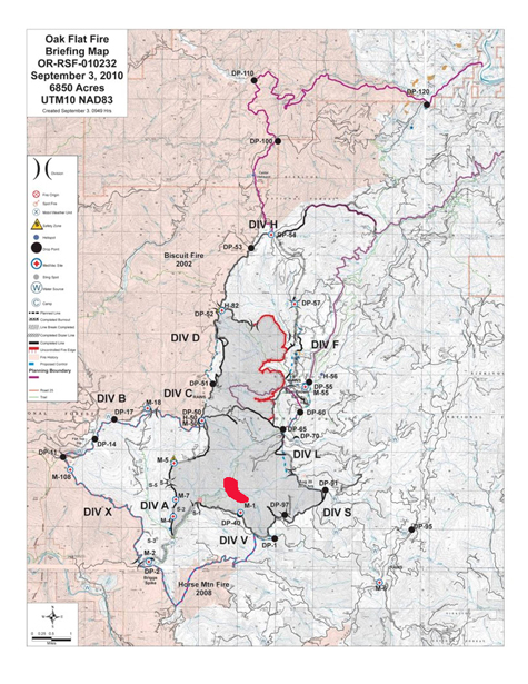
They are only half way there. Ground-based and aerial burnouts continue in Divisions D,F, & L. The red area shows the fire size on Aug 14 when the plan was drawn to incinerate 12,000 acres (now 18,000 acres, purple lines).
Despite calm winds, rain, and cool weather, arsonistic firecrews have managed to expand the fire again and again.
Nearly $17 million has already been spent, but the meter is still running. Over $100 million in resource damages have already been inflicted, including incineration of spotted owl nesting and foraging habitat.
More destruction of old-growth owl forests is occurring in the View Lake Let It Burn Complex Fires [here] on the Mount Hood National Forest. The Olallie Lakes area has been burned over, but those fires have been largely contained. Adjacent is the Bull of the Woods Wilderness, and those fires have been Let Burn. Over 2,700 acres of old-growth spotted owl habitat has been burned dead while firecrews stay as far away as possible [here].
But they do rake in the coin. Over $7 million has been spent on the View Lake Let It Burn Complex Fires and that meter is still running, too. Portland NIMO IMT [here] is taking over from the The Southern Cascades Type 3 Interagency IMT so they can get in on the cash flow while watching Oregon’s old-growth being catastrophically destroyed.
Because it isn’t about forests, or protecting them. It is about looting the Federal Treasury while arsonistically destroying America’s priceless, heritage forests.
Meanwhile noted Oregon Communists Ron Wyden, Pete DeFazio, and Ted Kulongoski cheer from the sidelines.
Burn, baby, burn. Kill, baby, kill.
Climate Change Foils Fire Nazis
As the unusual August rain today pours down on dozens of Let Burn Fires across the West, the best laid plans of the holocauster forest destroyer “community” have been washed away.
Even napalm won’t work when the humidity is this high and the temperatures this low.
The climate change that has altered the Pacific Northwest is due to the shift in the Pacific Decadal Oscillation which has taken place over the last 3 years or so. Colder water is upwelling in the northern eastern Pacific, a condition absent over the last 30 years, but now back for a 3-decade term.
Add to that the growing La Nina in the central Pacific (more cooling of the water off our shores), and a cold wet spell has engulfed us.
Last winter was the coldest and wettest on record, summer was two months late, and now fall is a month early. As the saying goes, summer was the nicest day we had this year.
Great plans were afoot to burn umpteen million acres of America’s priceless heritage forests this summer, and the fire nazis did their best. Not only were numerous wildfires unfought, but arsonistic sub-functionaries attempted to torch off more and more acres — using drip torches and ping pong balls filled with gasoline, dropped from helicopters.
Before the fire season started, various fire pundits predicted a monstrous burning summer. The cold, wet winter and spring had spurred more than the average growth, you see, and all that excess biomass was going to fuel the fires of their dreams.
No mention was made of the biomass that had been building up for 100 years or more. Just this year’s early growth was all that mattered to the pundits. They also tore their hair out over the “early snowmelt” and “late fall” and “extended burning season” indicated by their funk-tastic models. Don’t measure anything — real data aren’t necessary — just plug fantasy into creative equations and voila!, garbage spews out.
But their models were wrong, completely wrong, utterly wrong. Bang the Gong Show gong. Summer was late and fall has come early, just the opposite of the predictions of the chrome domes.
The Alarmist consensus turned out to be a confederacy of dunces. Cue the clown music…
Far be it from me to rub it in, but I TOLD YOU SO!!!!!
First Reports on Fire Blow-ups
As we predicted yesterday, wildfires are blowing up across the West due to two factors: high winds driven by the cold front moving through, and the criminal propensity of the USFS to kindle and expand wildfires rather than suppressing them.
The following reports were gleaned from today’s updates at W.I.S.E. Fire Tracking, a free service provided free of charge to the entire world for no remuneration. It’s free, for your edification, should you wish to avail yourself of the opportunity to become informed.
The fires listed below are a small portion of the active fires burning today. Many fires were not updated this morning, and the winds from the cold front have not yet reached some of them. It is not our fault that fire reports emanating from the USFS are sparse, late, incomplete, and often incompetent.
***************
View Lake Let It Burn Complex Fires [here]
Situation as of 08/26/2010 5:00 pm
Personnel: 604 (up from 333 yesterday)
Size: 3,037 acres (up from 776 acres yesterday)
Percent Contained: 30% (this number is meaningless)
Costs to Date: $2,731,000 (estimate is too low)
Type 3 IMT withdrawn. PNW Team 2 (Type 1 National IMT, Hoff) assumed command of the fire at 0600 today. Yesterday’s strong winds and unstable conditions resulted in a 5-fold growth in the size of the fire. An 80 acres spot fire developed east of the Pyramid Butte Fire (formerly Fire 264) now on the Warm Springs Reservation. No action on fires located in the Bull of the Woods Wilderness.
A decision was made to line a portion of the Pyramid Butte Fire.
Closures for Breitenbush, Harvey and Trout Lake areas.
***************
Scott Mountain Let It Burn Fire [here]
Situation as of 08/26/2010 4:00 pm
Personnel: 440 (up from 147 yesterday)
Size: 2,559 acres (up from 600 yesterday)
Percent Contained: 5% (this number is meaningless)
Costs to Date: numbers reported are incompetent
The new strategy is Let It Burn, in violation of the Willamette NF LMRP and FMP.
***************
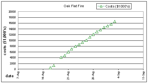
Oak Flat “Appropriate Response” Fire [here]
Situation as of 08/26/2010 6:00 pm
Personnel: 959 (up from 762 yesterday)
Size: 5,708 acres (up from 4,760 yesterday)
Percent Contained: 60% (this number is meaningless)
Costs to Date: $10,010,496
Another 1,000 acres deliberately incinerated yesterday, at an additional cost of $1 million. This fire could have been contained at 800 acres. Everything burned in excess of that is deliberate, malicious arson on the part of the USFS.
The ORCA IMT is without a doubt the most inept and destructive IMT in the nation. The RR-SNF and Region 6 are run by incompetent leftwing political appointees with absolutely no conception of how to manage forests.
***************
Phoenix Let It Burn Fire [here]
Location: 4 mi NE of Crater Lake, Klamath Co. OR
Specific Location: NE corner of Crater Lake National Park, 1 mi S of Hwy 138 , Lat 43° 4´ 18″ Lon 122° 1´ 14″
Date of Origin: 08/17/2010 (reported for the first time today)
Cause: Lightning
Situation as of 08/26/2010 4:00 pm
Personnel: 52
Size: 200 acres (a guess-timate)
Percent Contained: 0%
Desired incineration area: 2,500 acres
Significant growth occurred on the Phoenix Fire yesterday due to strong, gusty winds from the predicted cold front moving through. No effort being made to line or otherwise control this fire.
***************
Banner Let It Burn Fire [here]
Situation as of 08/26/2010 6:00 pm
Personnel: 542 (down from 561 yesterday)
Size: 2,365 acres (up from 2,077 yesterday)
Percent Contained: 20% (this number is meaningless)
Costs to Date: $2,908,000
Incident strategies: 57% of fire is containment; 33% of fire is “limited supression” [sic].
The cold front had not yet hit with full force at the time of the 209 report. Red Flag warning today for winds and low RH; lightning on the fire with light precipitation.
***************
Climate and Weather Federal forest policy Monkeywrenching forests The 2010 Fire Season
by admin
1 comment
Big Whoosh
The cold front is blowing by right now here in the Willamette Valley. Trees are swaying, the wind chimes are ringing, and the temperature has dropped 15 degrees. This place is protected by topography from most of the wind, but clouds are winging eastward at high speed, indicating that winds aloft are quite strong.
From the National Weather Service this morning:
URGENT - FIRE WEATHER MESSAGE - NATIONAL WEATHER SERVICE
RED FLAG WARNING IN EFFECT FOR NW CALIFORNIA, EASTERN OREGON, EASTERN WASHINGTON, NORTHERN NEVADA, IDAHO, MONTANA, WESTERN WYOMING
LOW RELATIVE HUMIDITIES AND STRONG SOUTHWEST WINDS WILL CREATE CRITICAL FIRE WEATHER CONDITIONS
A RED FLAG WARNING MEANS THAT CRITICAL FIRE WEATHER CONDITIONS ARE EITHER OCCURRING NOW…OR WILL SHORTLY. THESE CONDITIONS WILL CREATE THE POTENTIAL FOR EXPLOSIVE FIRE GROWTH.
Current Red Flag Warning Products [here]
The cold front will pick up speed as it surmounts the Cascades and sweeps across the Columbia Plateau. When it reaches Idaho, ground winds will gust up to 50 mph or more. There the winds will encounter a number of Let It Burn fires — Federal fires that should have been contained weeks ago but instead have been allowed to grow and incinerate America’s priceless heritage forests.
Current Large Incidents Map (click for larger image)
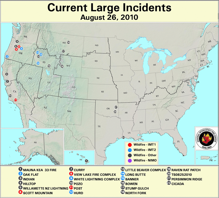
Fires currently burning (some of which are not on the map) include:
Larkins Let It Burn Complex Fires (ID); Clearwater NF; Size: 749 acres; Percent Contained: 0% [here]
Scott Mountain Let It Burn Fire (OR); Willamette NF (OR); Size: 935 acres; Percent Contained: 0% [here]
Gravel Let It Burn Fire (WY); Bridger-Teton NF; Size: 433 acres; Percent Contained: 0% [here]
Hurd Fire (ID); Boise NF; Size: 506 acres; Percent Contained: 15% [here]
Alder Creek Fire (ID); Lolo NF; Size: 425 acres; Percent Contained: 5% [here]
Fire 264 Let It Burn Complex (OR); Mt. Hood NF; Size: 500+ acres; Percent Contained: 0% [here]
Banner Let It Burn Fire (ID); Salmon-Challis NF; Size: 2,077 acres; Percent Contained: 18% [here]
White Lightning Fire (OR); Warm Springs Reservation; Size: 33,016 acres; Percent Contained: 40% [here]
Eight Mile Lake Let It Burn Fire (WA); Okanogan-Wenatchee NF; Size: 119 acres; Percent Contained: 0% [here]
Arthur 2 Let It Burn Fire (WY); Yellowstone National Park; Size: 200 acres; Percent Contained: 0% [here]
Vernon Let It Burn Fire (CA); Yosemite National Park; Size: 160 acres; Percent Contained: 0% [here]
Thunder Let It Burn Fire (WA); Okanogan-Wenatchee NF; Size: 125 acres; Percent Contained: 0% [here]
Oak Flat “Appropriate Response” Fire (OR); Rogue River-Siskiyou NF; Size: 4,760 acres; Percent Contained: 75% (allegedly) [here]
Sheep Let It Burn Fire (CA); Kings Canyon National Park; Size: 2,425 acres; Percent Contained: 0% [here]
Hopper Let It Burn Fire (WA); Olympic National Park; Size: 385 acres; Percent Contained: 15% (not by firefighters) [here]
Little Beaver Complex Let It Burn Fire (ID); Boise NF; Size: 5,350 acres; Percent Contained: 0% [here]
Bighorn Let It Burn Fire (ID); Salmon-Challis NF; Size: 1,128 acres; Percent Contained: 0% [here]
Bull Let It Burn Fire (WY); Bridger-Teton NF; Size: 3,539 acres; Percent Contained: 0% [here]
Twitchell Canyon Let It Burn Fire (UT); Fishlake NF; Size: 4,482 acres; Percent Contained: 0% [here]
This is the centennial year of the Great Fires of 1910, and much discussion has taken place about megafires and why, how, and when they arise [here].
From old SOS Forests, the archived version [here]
Palousers
July 24th, 2007
… Today the wind shifted, and a cold, dry front is blowing through right now as I type. The clouds have cleared, the sky is blue, the sun is shining, it’s 60 degrees in the shade at 10 AM, and the wind is from northwest at 15 to 20 mph. That’s what a cold front in July looks and feels like around here.
Whereas the weather here in western Oregon is balmy, across the Cascades to the east something else is happening. The same fronts are blowing across the continental plateau between the Cascades and the Rockies, but with a magnified effect. When southwesterly warm fronts swap places with northwesterly cold and dry fronts over the continent, big winds are generated.
A 15 mph wind in western Oregon can turn into a 50 mph wind on the high deserts of eastern Oregon and Washington, and then it can slam into Idaho and Montana and go sweeping down the other side of the Rockies into Wyoming and the Dakotas at gale force.
These summer westerly wind storms are known as Palousers because they seem to arise in the rolling loess hills of the Palouse.
Palousers happen every summer, in pulses, as warm and cold fronts passing over the PNW interact. Most summers they are mild to strong. Some summers Palousers arise that are near hurricane force.
The windstorm of August 20-21, 1910, blew smoldering fires in the Northern Rockies into a firestorm that incinerated 3 million acres in 48 hours, killed at least 85 people, completely destroyed five towns, and partially destroyed two others, at a time when the region was sparsely populated.
That was a Palouser.
From Pyne, Stephen J., Year of the Fires: The Story of the Great Fires of 1910. 2001 Viking Press:
The old-timer was right. The fate of the fire season resided in the swirling dice rolls of the wind. The usual pattern was for cold fronts to ripple across the region every three to five days. In advance of each front, winds would freshen from the southwest, then shift to the northwest after passage. The frontal waves became a vast, slow bellows, drawing in warm, moist air from the south before driving it out with cooler dry air from the north. …The train of fronts that rattled through the Northwest beginning in early July captured this arc of moist air, gulping it in, then exhaling it out. The rhythm of the fronts set the rhythm of the burning.
Each surge of air would stir up old flames and trigger dry lightning storms that kindled new fires. …In the Northern Rockies the approaching fronts drew the winds from the arid Columbia Plains and loess-capped Palouse–thus the Palousers of which the old-timer warned Morris. This was an ancient rhythm. But in 1910 the drought was worse, the storms held more lightning and less rain, the organization sagged from fatigue. The mid-July fire bust strained the Forest Service to its limits. Yet there was no real pause; climax followed climax; the big breakout of 23 July; the flare-ups of 1-2 August, 11-12 August, and 16-17 August; the Big Blowup of 20-21 August. Each built on the last, each fanned little fires into big ones and big ones into conflagrations, until at last a dusting of cold and wet began to dampen them out on 24 August. …
That post was sadly prophetic. The cold front of July 24, 2007, fanned a dozen Let It Burn fires in Idaho and led to the incineration of much of the Payette and Boise National Forests. Over 800,000 acres (1,250 square miles) of forested watersheds were fried [here, here].
What we wrote then still applies:
Big winds plus active fires can lead to regional firestorms. It has happened before. Conditions today are very similar to those in the Summer of 1910, except perhaps that the fuel loadings are much greater, and of course, a few million people live in Idaho and Montana now, with all their homes and stuff.
A regional firestorm today would be one of the most terrible disasters ever to strike in American history. Whatever we can do to avoid it, like putting the fires out [instead of allowing them to burn] and pre-treating the forests and ranges (too late for that this summer), we ought to do.
Federal forest policy Forestry education Saving Forests The 2010 Fire Season
by admin
11 comments
Some Let It Burn Questions Answered
Correspondent Zeke asked some pertinent questions regarding the Oak Flat Fire [here].
Dear Zeke,
Thank you for your questions. Here are the answers:
1. This fire could indeed have been contained at 800 acres. On Aug 15 the fire grew from 600 to 800 acres. On that date there were already nearly 500 firefighting personnel on the scene, 8 helicopters, and air tankers standing by in Medford.
The area is not “wilderness” or roadless. It is well-roaded throughout. No additional dozer work was necessary to contain the fire. There have been no strong winds so far, thank goodness, or the fire would have swept into Grants Pass within hours. Allowing the fire to grow and grow for weeks on end runs the risk that winds will arise and the fire will become a major disaster, burning farms, homes, towns, and cities. The USFS has chosen to endanger tens of thousands of residents, none of whom had any say so in the matter. That increased risk is manifest right now and will be for weeks to come.
2. It was and is possible to SAFELY put this fire out by ‘going direct’ on it. Indirect attack is LESS SAFE. Right now the “plan” is to put 1,000 firefighters a day for weeks on this fire. That is 10 to 20 times the man-hours necessary to contain it. By expanding the man-hours enormously, the risk of accidents increases.
Most firefighting injuries and fatalities are not due to burning up. They are due to machine accidents and fireline accidents, such as helicopter crashes and falling trees. The chance that those kind of accidents will occur is INCREASED by extending the fire for weeks and by extending the fire perimeter 10-fold.
3. There are no “benefits” to resources from wildfire. The USFS does not claim such. The use of the term “wildland fire used for resource benefit” is kaput. You can read the memo [here].
It is important to note that the deliberate use of fire produces significant impacts to the environment. We have laws regarding federal agencies impacting the environment, such as NEPA. If you read that law, you will note that “benefit” or “detriment” do not matter. What matters is whether the impacts are “significant”. No one argues that fire effects are insignificant.
Yet the USFS did not follow the legally mandated NEPA process before deciding to expand this fire ten-fold. They broke the law. That makes them criminals. Nobody wants federal agencies to break the law. I don’t at any rate. Do you?
For more discussion on this aspect, see [here, here, here, here].
4. Instead of looking at Google Earth, you may wish to examine the forest road map. That will show you the existing road density of the area. The road network is extensive. No new roads are needed, or new dozer lines, to contain this fire.
5. 6. 7. So you think that they could have held it to this footprint? Have you ever fought fire in that country? Are you an expert on wildfire tactics? Yes, Yes, Yes.
8. Is anything about that ground worth killing a single firefighter? Hold on there, Zeke. I am not for killing anybody. As I discussed above, extending the fire in time and space INCREASES the risks to firefighters.
In 2008 over 650,000 acres were incinerated in Northern California on the Shasta-Trinity, Six Rivers, and Klamath National Forests. The fires were allowed to burn vast tracts in accord with a revised fire policy the USFS called “Appropriate Management Response” (since then the USFS has dropped that lingo term, too). Building firelines miles away from the fires and backburning hundreds of thousands of acres of private and public land alike were deemed “appropriate.” Despite the remote firefighting techniques, ostensibly intended to save money and protect firefighters, over $400 million was spent on suppression and 12 firefighters were killed.
In 2009 direct attack was used on a fire in the same area. The Backbone Fire [here] was 6,100 acres in steep un-roaded country when the decision was made to use direct attack. The fire was 100% contained within a week at 6,324 acres, with no accidents and no fatalities.
So you see, Zeke, extending this fire is far more likely to result in death to firefighters than direct attack would have. Perhaps you should aim your “killing firefighters” question at the USFS instead of at me.
9. What do you hope to accomplish with your rant? My purpose, indeed the purpose of W.I.S.E., is to educate. The “rant” characterization is impolite on your part, but whatever the literary quality, my post caught your attention. And now I am educating you further. Please read (study) the links provided. You have much to learn, and we are here to aid you in that.
Thank you again for your questions. Please feel free to ask us such good questions anytime.
Sincerely,
Mike Dubrasich, Exec Dir W.I.S.E.
Federal forest policy Monkeywrenching forests The 2010 Fire Season
by admin
11 comments
Criminal Incineration of the Rogue River-Siskiyou NF
The Oak Flat Fire [here] was reported this morning to be 1,706 acres. The plan, however, is to allow the fire to grow to 12,000 acres, either through inaction or deliberate backfiring.
The Oak Flat Fire was ignited by unknown causes in the Briggs Creek area of Rogue River-Siskiyou NF, about 10 miles west of habitations in the Rogue River Valley and 8 miles northwest of the community of Selma in the Illinois River Valley.
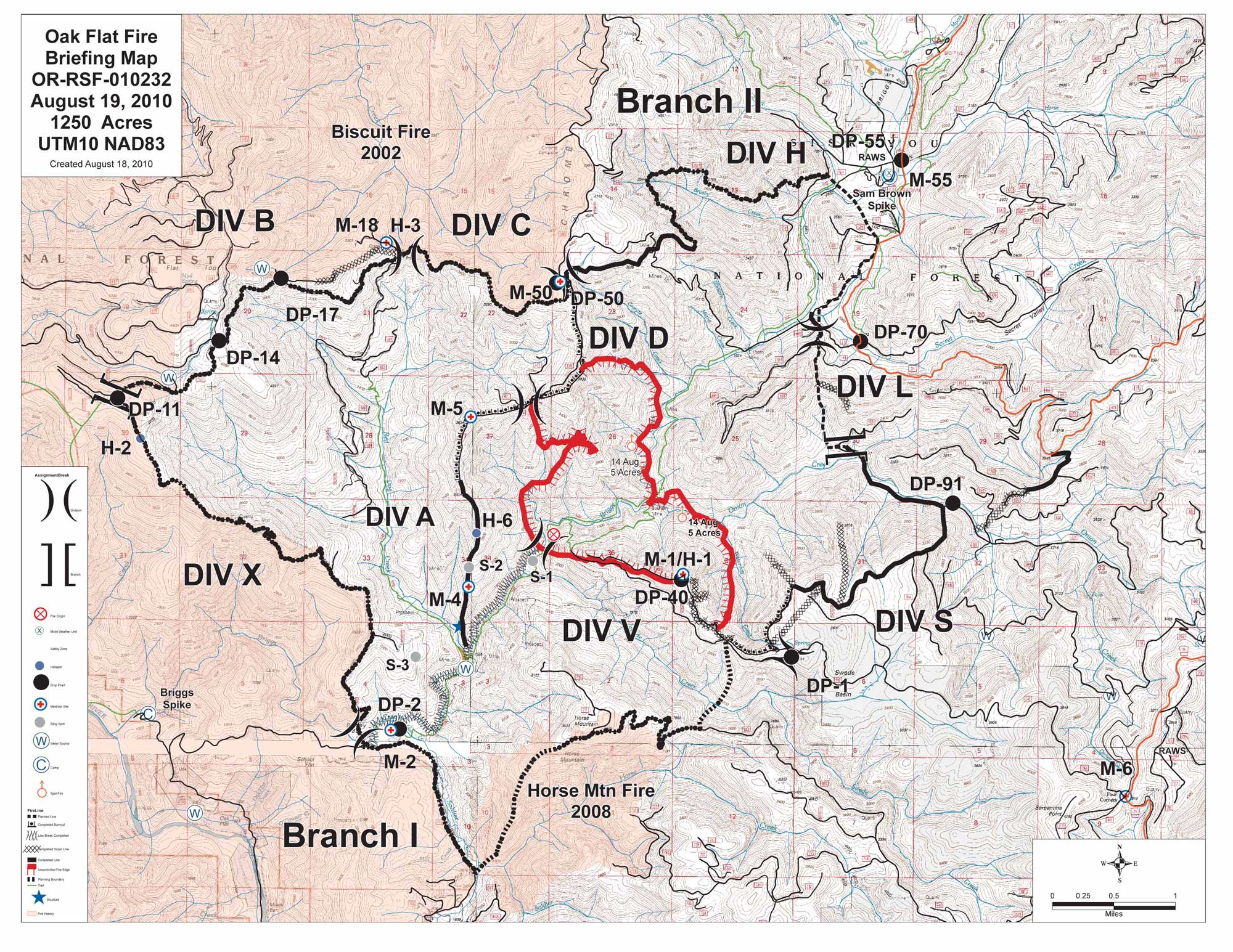
Oak Flat Fire Briefing Map, August 19, 2010. From InciWeb [here]. Click for larger image.
The red outlined area is the current fire perimeter. The black lines indicate the positions of the “indirect” fire lines planned by the Southern Oregon/Northern California Type II Interagency IMT Incident Commander Brett Fillis [here] in collaboration with the Rogue River-Siskiyou NF Forest Supervisor Scott Conroy, and with the approval of Region 6 Regional Forester Mary Wagner.
The black lines encompass approximately 12,000 acres. The area to be burned includes portions of the Illinois Valley Wild and Scenic River corridor. It also includes known nesting sites of the Northern Spotted Owl, a species on the Threatened and Endangered Species list.
InciWeb reported:
…[F]ire managers are planning to conduct burnout operations aimed at efficiently connecting the fire into the containment lines within the few days. Both ground and aerial ignition methods will be used, with particular attention paid to minimizing tree mortality and preserving spotted owl habitat. …
The Regional Forester reviewed the fire management plan, activities and organization on Thursday, 8/19/10.
That language implies that deliberate ignition of spotted owls stands will be occurring as the fire managers expand the footprint of the fire 10-fold. Further, those operations have been approved by Regional Forester Mary Wagner.
Deliberate incineration of endangered species habitat is a violation of the Endangered Species Act. The USFS has not conducted any NEPA analysis, such as an Environmental Impact Statement. Nor have they conducted any Section 7 (of the ESA) consultation with the US Fish and Wildlife Service.
The entire area is an ancient cultural landscape, as indicated by place names such as Oak Flat and Onion Mountain. Soldier Creek was named during the Rogue River Indian Wars [here] of the 1850’s. As such the area has significant archaelogical and heritage sites. No Section 106 review (of the National Historical Preservation Act [here]) has been conducted.
The USFS is well-aware that deliberately expanding a wildfire by backburning thousands of acres of legally protected landscapes is illegal.
In March of 2008, the Rogue River-Siskiyou National Forest issued a notice of intent to produce a Fire Use Amendment Environmental Assessment [here] that would change the language in their Land and Resource Management Plan and Fire Management Plan to include “allowing” wildfires to burn across vast acreages.
That plan amendment has NOT been adopted. Serious objections have been raised and appeals filed. What the final outcome will be is unknown, but the Fire Use Amendment has NOT been adopted as yet.
Regardless, USFS officials are proceeding as if the laws do not apply to them.
This is not the first time the Rogue River-Siskiyou NF has ignored the law. Adjacent to the planned fire perimeter of the Oak Flat Fire is the Biscuit Burn, a 500,000 acre scar that resulted from a Let It Burn fire of 2002. The Biscuit Fire was the largest fire in Oregon state history and eventually cost over $150 million to suppress when it blew up into a 12-mile-long fire front and threatened the communities of Selma and Grants Pass (the same communities now threatened by the Oak Flat Fire).
Over 75 Northern Spotted Owl nesting sites were destroyed by the Biscuit Fire.
In 2008 the Rogue River-Siskiyou NF perpetrated another illegal Let It Burn fire, the Lonesome Complex/Middlefork Fire [here], which was allowed to grow from 500 acres to 21,000 acres, incinerating numerous old-growth and Northern Spotted Owl nesting stands.
The criminal activities by Federal government functionaries on the Oak Flat Fire will have devastating impacts to wildlife, wildlife habitat, heritage, scenery, recreation, and other natural resources. Those impacts will be long-lasting. Furthermore, allowing the fire to burn for weeks on end will pour smoke into communities and cause severe public health problems. Expanding the planned fire perimeter and backfiring thousands of acres will exacerbate those damages.
Allowing the fire to burn for weeks on end also runs the risk that a wind event could cause a fire blow-up and carry the fire to private lands and communities.
None of those communities, or their elected officials or representatives, have any influence over the USFS fire decisions. The USFS acts like an occupying army with no regard for the local residents or the law, and with the malicious intent to devastate and destroy watersheds and landscapes no matter what the impact may be resources or to the local communities.
The Oak Flat Fire is growing and will continue to grow, due to deliberate actions of the USFS, because the criminals in charge feel that they are impervious to legalities and public opinion. But there will be a denouement after this fire. Their crimes will not be swept under the rug this time.
Politics and politicians Restoring cultural landscapes Saving Forests The 2010 Fire Season
by admin
1 comment
Another Forest Tragedy
The Rooster Rock Fire [here] near Sisters, Oregon is now 6,124 acres and 65% contained. It is unlikely to grow any larger because winds have died down and the CO2’s (Central Oregon Type 2 Incident Management Team, Mark Rapp I.C.) in cooperation with the Oregon Dept. of Forestry have done their usual excellent job of controlling the fire.
The fire began from unknown causes on US Forest Service (Deschutes NF) land on August 2nd. It quickly spread east and south to private lands. Approximately three-quarters of the area burned by the Rooster Rock Fire is private land.
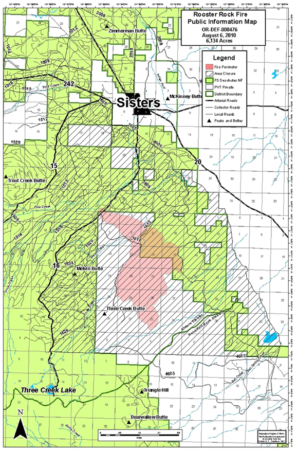
Rooster Rock Fire Map, 08/06/2010, courtesy Central Oregon IMT. Click for larger image.
The fire was about 5 miles south of Sisters. A few homes were evacuated, but the evacuations have now been lifted. An estimated 50 homes were threatened, but no homes burned.
The Rooster Rock Fire was the 13th large fire in the northern Deschutes NF in the last 8 years. Over 160,000 acres, primarily in the the Metolius River watershed, have been incinerated. The scar of burned old-growth now extends from Warm Springs to the north to the Three Sisters Wilderness to the south, from the Cascade Crest to private lands to the east. The following Burns make up this destroyed forest landscape (this list is missing a few smaller ones):
Cache Mountain Fire (2002) - 3,894 acs
Eyerly Complex Fires (2002) - 23,573 acs
B&B Complex Fires (2003) - 90,769 acs
Link Fire (2003) - 3,574 acs
Black Crater Fire (2006) - 9,400 acs
Puzzle Fire (2006) - 6,150 acs
Lake George Fire (2006) - 5,740 acs
GW Fire (2007) - 7,500 acs
Dry Creek Fire (2008) - 110 acs
Summit Springs Complex Fires (2008) - 1,973 acs
Wizard Fire (2008) - 1,840 acs
Black Butte II Fire (2009) - 578 acs
Rooster Rock Fire (2010) - 6,124 acs
Total - 161,225 acres in eight fire seasons