Nataraja: India’s Cycle of Fire
Stephen J. Pyne. 1994. Nataraja: India’s Cycle of Fire. Environmental History Review, Vol. 18, No. 3 (Autumn, 1994), pp. 1-20.
Full text [here]
Selected excerpts:
In the center dances Shiva, a drum in one hand and a torch in the other, while all around flames inscribe an endless cycle of fire.
This-the nataraja, the Lord of the Dance-is more than one of Hinduism’s favored icons. It is a near-perfect symbol of Indian fire history. The drum represents the rhythm of life; the torch, death; the wheel of flame, the mandala of birth, death, and rebirth that fire epitomizes and makes possible. In this confrontation of opposites the dance replaces the dialectic; Shiva holds, not reconciles, both drum and torch. Considered ecologically the nataraja thus expresses in graphic language the great polarity of India, the annual alternation of wet and dry seasons by which the monsoon, with faint transition, imposes its opposing principles on the subcontinent.
India’s biota, like Shiva, dances to their peculiar rhythm while fire turns the timeless wheel of the world. Perhaps nowhere else have the natural and the cultural parameters of fire converged so closely and so clearly. Human society and Indian biota resemble one other with uncanny fidelity. They share common origins, display a similar syncretism, organize themselves along related principles. Such has been their interaction over millennia that the geography of one reveals the geography of the other. The mosaic of peoples is interdependent with the mosaic of landscapes, not only as a reflection of those lands but as an active shaper of them (emphasis added). Indian geography is thus an expression of Indian history, but that history has a distinctive character, of which the nataraja is synecdoche, a timeless cycle that begins and ends with fire.
The cycle originated with the passage of India as a fragment of Gondwana into a violent merger with Eurasia. The journey northward, through the fiery tropics; the violence of the great Deccan basalt flows and of the immense collision with Asia; the installment of seasonality in the form of the monsoon-all this purged the subcontinent of much of its Gondwana biota, and tempered the rest to drought and fire. The populating of India came instead by influx from outside lands, followed by varying degrees of assimilation. Here, in the choreography of the nataraja, east met west, Eurasia confronted Gondwana, wet paired with dry, life danced with death.
What endemics remained were, like India’s tribal peoples, scattered or crowded into hilly enclaves. Only 6.5% of India’s flowering plants are endemic, compared with 85% in Madagascar and 60% in Australia. The residual biota thrived most fully to the south; Peninsular India holds a third of the subcontinent’s endemic flora. Some species, Asian in character, entered from the northeast. A diffuse array emigrated from the eastern Mediterranean, the steppes, and even Siberia, the Himalayas serving less as a barrier than a corridor. More recently weeds, largely European, have established themselves. The composition of its biota thus recapitulates the composition of its human population-the tribal peoples, their origins obscured; the Dravidians who persevered on the Deccan plateau and to the south; the Southeast Asians, migrating through Assam and Bengal; the Aryans, Huns, Turks, Persians, Pathans, Mongols, and others, entering from the northwest; and Arabs and Europeans, mostly Portuguese and British, arriving by sea.
The geographic ensemble that emerged from this vast convergence was both familiar and unique. Of course there were broad divisions, Asians here, Dravidians here. Of course there were mosaics of field, grassland, and forest, in part because of human influence. But even beyond such matters, this syncretic biota assumed the character of something like a caste society. It is probable that this was no accident. The organization of Indian society impressed itself on the land, with ever greater force and intricacy. Tribal people gathered into disease-ridden hills, better shielded genetically from malaria and other ills. They then reworked those hills in ways that conferred on them a biotic identity. It is no accident that the species most commonly found in habited areas are those most abundantly exploited by the human inhabitants, and are often those best adapted to fire. European weeds, like forts and factories, gathered into specially disturbed sites, then spread along corridors of travel or secondary disturbance. The intricate division of Indian society by caste ensured that different peoples did particular things at particular times, and this was reflected in the landscape of India, not only between regions but within areas that different groups exploited at different times in different ways for different purposes.
The intensity of the monsoon assured-demanded-a place for fire. The sharper the gradient, the more vigorous the potential for burning. Some of the wettest places on Earth, like the Shillong Hills, could paradoxically experience fire and even fire-degraded landscapes. The biota, already adapted to rough handling by India’s passage north, responded to fire readily. The flora and fauna that humans introduced, or that migrated into India coincidental with them, also had to be fire-hardened because humans added to and often dominated the spectrum of environmental disturbances and they certainly exploited fire. Explorers and ethnographers reported the practice among southern tribal groups (and in the Andaman Islands) of habitually carrying firesticks, a practice relatively rare outside of Australia and a few other regions. Probably Radcliffe-Brown’s peroration on fire and the Andaman Islanders could stand for most tribal peoples on the subcontinent. Fire, he concluded,
… may be said to be the one object on which the society most of all depends for its well-being. It provides warmth on cold nights; it is the means whereby they prepare their food, for they eat nothing raw save a few fruits; it is a possession that has to be constantly guarded, for they have no means of producing it, and must therefore take care to keep it always alight; it is the first thing they think of carrying with them when they go on a journey by land or sea; it is the centre around which the social life moves, the family hearth being the centre of the family life, while the communal cooking place is the centre round which the men often gather after the day’s hunting is over. To the mind of the Andaman Islander, therefor, the social life of which his own life is a fragment, the social well-being which is the source of his own happiness, depend upon the possession of fire, without which the society could not exist. In this way it comes about that his dependence on the society appears in his consciousness as a sense of dependence upon fire and a belief that it possesses power to protect him from dangers of all kinds.
The belief in the protective power of fire is very strong. A man would never move even a few yards out of camp at night without a firestick. More than any other object fire is believed to keep away the spirits that cause disease and death. …
The Columbian Encounter and the Little Ice Age: Abrupt Land Use Change, Fire, and Greenhouse Forcing
Robert A. Dull, Richard J. Nevle, William I. Woods, Dennis K. Bird, Shiri Avnery, and William M. Denevan. 2010. The Columbian Encounter and the Little Ice Age: Abrupt Land Use Change, Fire, and Greenhouse Forcing. Annals of the Association of American Geographers, 100(4) 2010, pp. 1–17.
Full text [here]
Selected excerpts:
Abstract
Pre-Columbian farmers of the Neotropical lowlands numbered an estimated 25 million by 1492, with at least 80 percent living within forest biomes. It is now well established that significant areas of Neotropical forests were cleared and burned to facilitate agricultural activities before the arrival of Europeans. Paleoecological and archaeological evidence shows that demographic pressure on forest resources—facilitated by anthropogenic burning—increased steadily throughout the Late Holocene, peaking when Europeans arrived in the late fifteenth century. The introduction of Old World diseases led to recurrent epidemics and resulted in an unprecedented population crash throughout the Neotropics. The rapid demographic collapse was mostly complete by 1650, by which time it is estimated that about 95 percent of all indigenous inhabitants of the region had perished. We review fire history records from throughout the Neotropical lowlands and report new high-resolution charcoal records and demographic estimates that together support the idea that the Neotropical lowlands went from being a net source of CO2 to the atmosphere before Columbus to a net carbon sink for several centuries following the Columbian encounter. We argue that the regrowth of Neotropical forests following the Columbian encounter led to terrestrial biospheric carbon sequestration on the order of 2 to 5 Pg C, thereby contributing to the well-documented decrease in atmospheric CO2 recorded in Antarctic ice cores from about 1500 through 1750, a trend previously attributed exclusively to decreases in solar irradiance and an increase in global volcanic activity. We conclude that the post-Columbian carbon sequestration event was a significant forcing mechanism.
Excerpts:
… Widespread biomass burning and agricultural forest clearance predate the Industrial Revolution by several millennia in the Americas, Africa, Asia, Europe, and Australia, as well as on many oceanic islands (Sauer 1958; Crutzen and Andreae 1990; Goldhammer 1991; Chew 2001; Saarnak 2001; Williams 2003). The idea that preindustrial Holocene land use could have produced quantities of atmospheric CO2 and CH4 sufficient to impact the climate system was first outlined by Ruddiman’s (2003) seminal paper, “The Anthropogenic Greenhouse Era Began Thousands of Years Ago.” Although evidence mounts for a preindustrial Anthropocene (Ruddiman 2003, 2005, 2007; Faust et al. 2006; van Hoof et al. 2006; Nevle and Bird 2008; van Hoof et al. 2008; Vavrus, Ruddiman, and Kutzbach 2008), some critics maintain that human impacts in terms of climate forcing were negligible until the nineteenth century (Broecker and Stocker 2006; Olofsson and Hickler 2008; Elsig et al. 2009; Stocker, Strassmann, and Joos 2010).
If pre-industrial farmers did contribute measurably to the greenhouse effect via increased emissions of CO2 and methane, only a massive and catastrophic collapse of agricultural populations could have led to significant decreases in anthropogenic emissions at any time. The post-Columbian encounter epidemics and pandemics were certainly the most rapid, thorough, and widespread to have occurred during the late Holocene (Crosby 1972; Lovell 1992), resulting in a loss of approximately 90 to 95 percent of the agricultural population throughout the Neotropics (Dobyns 1966; Lovell and Lutz 1995). The sixteenth- and seventeenth-century epidemics resulted in the abrupt abandonment of agricultural clearings in otherwise forested landscapes together with an unprecedented reduction in human fire ignitions, thus providing an ideal scenario for backcasting anthropogenic climate forcing before European contact. The widespread forest recovery that followed the native population crash after the Columbian encounter resulted in elevated biospheric sequestration of atmospheric CO2 in plant biomass because (1) forests rapidly reoccupied abandoned cultivated landscapes via secondary succession, and (2) existing forests became more carbon dense due to a reduction in wildfires related to anthropogenic fire ignitions, both intentional and accidental.
In this article we review the evidence for prehistoric anthropogenic biomass burning in the Neotropics and provide new data supporting the thesis that the aggregate carbon footprint of Neotropical farmers was sufficient to raise global temperatures via greenhouse forcing before the Columbian encounter. Furthermore, we argue that Little Ice Age (LIA) cooling and the attendant atmospheric CO2 decrease can be explained in part by biospheric carbon sequestration following the native population collapse. The LIA is identified in surface temperature reconstructions of the past millennium as a global thermal anomaly of about -0.1 deg C in which cooling was most pronounced from 1550 to 1750 AD in the Northern Hemisphere, particularly in northern Europe (Esper, Cook, and Schweingruber 2002; Jones and Mann 2004; Moberg et al. 2005). Atmospheric CO2 concentration decreased by ~7 ppm during the same period (Meure et al. 2006). Previously, the LIA thermal anomaly and concomitant decrease in atmospheric CO2 concentrations were attributed to solar–volcanic forcing (Joos et al. 1999; Hunt and Elliott 2002; Von Storch et al. 2004). Recent analyses, however, suggest that variations in solar luminosity are insufficient to drive significant climate variations on centennial to millennial timescales (Foukal et al. 2006), and were likely a negligible climate forcing factor at the onset of the LIA (Ammann et al. 2007). We conclude that the fifteenth- and sixteenth-century arrivals of Europeans in the Americas set into motion an unprecedented anthropogenic carbon sequestration event and contributed to the LIA climate anomaly. This event represents perhaps the best example of anthropogenic influence on Earth’s climate system during the pre-industrial period. …
Pre-Columbian agricultural landscapes, ecosystem engineers, and self-organized patchiness in Amazonia
Doyle McKey, Stephen Rostain, Jose Iriarte, Bruno Glaser, Jago Jonathan Birk, Irene Holst, Delphine Renard. 2010. Pre-Columbian agricultural landscapes, ecosystem engineers, and self-organized patchiness in Amazonia. Proc Natl Acad Sci USA. 107(17):7823-8.
Full text [here]
Abstract
The scale and nature of pre-Columbian human impacts in Amazonia are currently hotly debated. Whereas pre-Columbian people dramatically changed the distribution and abundance of species and habitats in some parts of Amazonia, their impact in other parts is less clear. Pioneer research asked whether their effects reached even further, changing how ecosystems function, but few in-depth studies have examined mechanisms underpinning the resilience of these modifications.
Combining archeology, archeobotany, paleoecology, soil science, ecology, and aerial imagery, we show that pre-Columbian farmers of the Guianas coast constructed large raised-field complexes, growing on them crops including maize, manioc, and squash. Farmers created physical and biogeochemical heterogeneity in flat, marshy environments by constructing raised fields. When these fields were later abandoned, the mosaic of well-drained islands in the flooded matrix set in motion self-organizing processes driven by ecosystem engineers (ants, termites, earthworms, and woody plants) that occur preferentially on abandoned raised fields.
Today, feedbacks generated by these ecosystem engineers maintain the human-initiated concentration of resources in these structures. Engineer organisms transport materials to abandoned raised fields and modify the structure and composition of their soils, reducing erodibility. The profound alteration of ecosystem functioning in these landscapes coconstructed by humans and nature has important implications for understanding Amazonian history and biodiversity. Furthermore, these landscapes show how sustainability of food-production systems can be enhanced by engineering into them fallows that maintain ecosystem services and biodiversity. Like anthropogenic dark earths in forested Amazonia, these self-organizing ecosystems illustrate the ecological complexity of the legacy of pre-Columbian land use.
Plain Facts: Tasmania under Aboriginal Management
Bill Gammage. 2008. Plain Facts: Tasmania under Aboriginal Management. Landscape Research, Vol. 33, No. 2, 241 – 254, April 2008.
Full text [here]
Selected excerpts
Abstract
Almost all researchers now accept that Australia’s Aborigines were managing their country with the broad-scale use of fire when Europeans arrived. In respect to Tasmania, this article goes further, arguing that fire was not merely broad-scale, but applied variably and precisely, to make, then connect, a complex range of useful ecosystems. The article also argues that Aboriginal land management must be seen in cultural as well as ecological terms.
*****
When Europeans arrived, the Aborigines of Tasmania were managing their land by using fire to arrange its vegetation. They did so to ensure that all species flourished as the Law required, to make resources abundant, convenient and predictable, and to make the land an integrated domain.
Although such acute early observers as Thomas Mitchell and Ludwig Leichhardt knew that Aborigines fired country to attract game,1 not until the 1960s did researchers begin to sense system and purpose in Aboriginal burning. From 1965, Bill Jackson argued that for thousands of years Tasmanians altered vegetation by deliberate and repeated firing.2 In 1968, Duncan Merrilees pointed to faunal changes in Australia which he thought could only have been caused by people.3 In 1968 and 1969, Rhys Jones showed that throughout Australia ‘fire-stick farming’ made a more complex vegetation mosaic than climate alone could dictate.4 In 1975, Sylvia Hallam provided extensive evidence of purposeful firing in southwest Western Australia.5 Debate persists on whether Aborigines intended the results of such widespread, purposeful and effective firing,6 but enough evidence exists to resolve this debate, and to take it further.
The broad impact of Aboriginal burning on Tasmania’s plants is sketched by the answers to two questions. When Europeans arrived:
1) What would the land have looked like without human intervention?
2) What did it look like?
Jackson concluded that deliberate burning best explains why there was much less rainforest in Tasmania when Europeans arrived than on New Zealand’s South Island, a comparable climate but generally without people.7 As its title hints, ‘Plain Facts’ begins by echoing Jackson, arguing that but for Tasmanian fire, plains, heath and open forest would have been much less common than they were when Europeans arrived, and rainforest more common. Tasmanians burnt rainforest to diversify and arrange their resources. …
The Ozette Prairies of Olympic National Park: Their Former Indigenous Uses and Management
M. Kat Anderson. 2009. The Ozette Prairies of Olympic National Park: Their Former Indigenous Uses and Management. Final Report to Olympic National Park, Port Angeles, Washington Winter 2009.
Full text [here] (3.2 MB)
Selected excerpts:
Introduction
The Ozette Prairies—openings of bog, fen, and grassland in a forest of Sitka spruce, western hemlock, and western redcedar—lie two kilometers east of the Pacific Ocean, well within hearing distance of barking sea lions on the rocky islands offshore. One can walk from these wetlands to the coast on the Cape Alava Trail, which cuts through the openings and the surrounding forest along the route of an old Indian trail (Waterman 1920). Wandering off the trail into the forest, the travel becomes slow and cumbersome; one has to straddle downed logs and bushwhack through shrubbery and young trees.
The wetlands, on the other hand, are easily and comfortably traversed. They are inviting landing sites for ducks and geese, habitat for ground-nesting birds, and are attractive to Roosevelt elk, blacktailed deer, and black bears. Before the coming of white settlers, they were also attractive to the Ozette Indians, who hunted and collected food and useful plants there for perhaps 2,000 years (Blinman 1980; Wessen 1984). The Ozette people would come to the Ozette Prairies from their village at Cape Alava on the Pacific Ocean, seeking young horsetail sprouts to eat in spring, the leaves of a particular sedge to weave into their baskets in summer, and bog cranberries, Indian tea leaves, and fern rhizomes in autumn.
They built shelters in the wetlands and dried and smoked their food there (Bertelson 1948; Gunther 1871-1981). Before 1910, two Swedish immigrants—Peter Roose and Lars Ahlstrom—filed 160 acre claims and moved onto these open areas, built structures, raised sheep and cattle, and planted vegetable gardens (see Figures 1 and 2). When Ahlstrom first moved to the area in 1902, he lived in an Ozette Indian hut and interacted with the Ozette as described by Bertelson (1948): “He got along fine with the Ozettes, and bought salvaged drift-boards and planks from them with which to build. And after he got settled and had acquired four cows, he traded butter and garden truck with the Indians for fish and game.”
Today, butterfly and plant experts view the Ozette Prairies as a wilderness refuge — a place sheltering unique plant and animal life. They are a biological focus area of the National Park Service because they represent excellence in beauty and biological diversity and harbor an array of rare and endangered plant and animal species (http://www1.dnr.wa.gov/nhp/refdesk/lists/plantrnk.html; Pyle 2002). In recognition of their cultural and ecological value, the wetlands have received official protection; their structures are on the National Register of Historic Places and the land is designated as wilderness or potential wilderness (Washington Park Wilderness Act of 1988; Ruth Scott pers. comm. 2007).
But formal designation alone is not enough to save the biotic diversity of these areas, as they are shrinking. Young western hemlock and redcedar trees, along with some Sitka spruce and Pacific yew, are advancing into the open habitats (see Figure 3). In the early 1940s, Alice Kalappa, Makah, complained to anthropologist Elizabeth Colson in an interview that “Now there are lots of trees on the [Ozette] marsh because nobody takes care of it anymore.” In 1981, Stephen Underwood, Ozette Subdistrict Ranger, wrote Olympic National Park visitors to solicit early photographs of the Ahlstrom’s Prairie. He received slides and prints of Ahlstrom’s Prairie from the early 1960s. He wrote the visitors thank you notes saying in one letter that “It’s impressive how much growth has occurred out on the prairie [between the early 1960s and 1981]” (Underwood 1981). Wetlands ecologist Linda Kunze documented tree encroachment on the Ozette Prairies in her unpublished botanical field notes in 1989 (see Appendix 1). Ed Tisch (2002:6) explained the tree encroachment onto Ahlstrom’s Prairie in an article in the Voice of the Wild Olympics magazine:
The highest, best-drained sites favor tree establishment. Most of these elevated areas currently support a hemlock\salal-evergreen huckleberry community type in which bracken, deer ferns, bunchberries, twinflowers, and beaked mosses are common, and the dominant shrubs grow to heights of three to ten feet. These expanding ‘forests’ are slowly repossessing.
Cultivated Landscapes Cultural Landscapes Fire History Native Cultures The Wilderness Myth
by admin
Comments Off
Before Columbus: The Americas of 1491
Charles C. Mann and Rebecca Stefoff. 2009. Before Columbus: The Americas of 1491. Atheneum Books for Young Readers, Simon & Schuster.
Available [here]
This book should be in every school.
The study of historical human influences on the environment is hampered by stubborn adherence to myths and falsehoods developed in childhood. Schools teach that Native Americans were few, savage, and insignificant wandering nomads who lived in a wilderness before Europeans arrived to tame the Americas.
Charles C. Mann’s 2005 bestseller, 1491: New Revelations of the Americas Before Columbus [here], exploded many of those myths. He essayed the new, developing ideas and evidence regarding pre-Columbian America indicating that the Western Hemisphere was populated by millions of people living in civilizations older and more advanced than those of the invading Europeans.
Now Mann and co-author Rebecca Stefoff have adapted 1491 into a book for school children. Before Columbus: The Americas of 1491 is a gorgeous “coffee table” book filled with vibrant pictures and a text that is exciting and understandable for younger scholars.
Teachers and parents take note. Don’t let your kids grow up to be ignorant of their roots. The landscapes we live in have been cultural landscapes, shaped by humanity, for thousands of years. The heritage of place is your heritage and that of your children.
Part One of Before Columbus: The Americas of 1491 examines the question “How Old was the New World?” Archaeologists keep pushing the date back, but without a doubt human beings were living throughout the Americas 10,000 years ago (8,000 BC). The first cities may have been along the Peruvian coast. The pyramids at Huaricanga are at least 5,500 years old. The residents also built irrigation canals to water cotton fields, from which they made nets to harvest fish. Ancient mariners sailed far out into the Pacific to net anchovies, sardines, and other fish. Their cultural stamp (the distinctive gods carved on gourds) can be seen in rock carvings and temples crafted thousands of years later at Lake Titicaca, the cradle of Incan civilization.
Part Two asks “Why Did Europe Succeed?” and includes four chapters on “The Great Meeting” (Cortez and the Aztecs at Tenochtitlan), “Long, Long Ago” (the first Americans, the PaleoIndians, and Monte Verde in Chile), “Extinction” (the demise of the megafauna, including mammoths), and “Disease-Free Paradise? (the impact of European disease on the Native Americans).”
Part Three examines “Were the Americas really a Wilderness?” It’s chapters include “Amazonia” with discussion of the fruit and nut orchards found across the Amazon Basin and the anthropogenic soils called terra preta. “Land of Fire” discusses the way in which Indians maintained a living anthropogenic mosaic of prairies, savannas, and open, park-like forests, principally through the use of controlled burning. In “The Created Wilderness” the authors explain how those human-shaped landscapes were abandoned when the Indian populations nearly disappeared following the introduction of Old World diseases.
We cannot plan for the future if we do not understand the past. Forests cannot be cared for, and the desired future conditions cannot be achieved, if we do not have a firm grasp on how our forests developed in the first place.
Mann and Stefoff seek to instruct our youth with the truth, so that as adults they can make informed judgments about environmental stewardship.
Buy this book. Better yet, buy a dozen copies and donate them to your local schools. Raise the consciousness about the distant past so that our coming future is guided by knowledge instead of myth.
Aboriginal Use of Fire: Are There Any “Natural” Plant Communities?
Gerald W. Williams. 2002. Aboriginal Use of Fire: Are There Any “Natural” Plant Communities? IN Wilderness and Political Ecology: Aboriginal Land Management–Myths and Reality, Charles E. Kay and Randy T. Simmons (eds.) University of Utah Press.
Full text [here]
Selected excerpts:
INTRODUCTION
Evidence for the purposeful use of fire by American Indians (also termed Native Americans, Indigenous People, and First Nations/People) in many ecosystems has been easy to document but difficult to substantiate. Commonly, many people, even researchers and ecologists, discount the fact that the American Indians greatly changed the ecosystems for their use and survival. Scientists often attribute old fire scars found in tree rings to “natural” causes, such as lightning rather than anthropogenic causes (Kilgore 1985 and Pyne 1995). However, there is a growing literature that many of the so-called “natural” fires were intentionally set. A knowledge of the Indian use of fire will understand how ecosystem conditions today have been shaped by humans in the past. The implications of restoring fire to ecosystems for management of million of acres of federal lands are profound.
The following accounts of Indian burning of ecosystems focuses on the Pacific Northwest, where some of the best documentation of Indian use of fire exists (see Appendix B). For other parts of North America, see the excellent studies by Henry Lewis (1982, 1985) on the forest areas of Canada, as well as the articles by Emily Russell (1983, 1997) and Gordon Whitney (1994) for the East (especially the northeast) and William McClain and Sherrie Elzinga (1994) for the Midwest region of the United States. Stephen Pyne’s (1982, 1995) books contain information on aboriginal people and their use of fire in North America, as well as other parts of the world.
“NATURAL” LANDSCAPES OF NORTH AMERICA
For over 100 years there was the idea that nature could only be “natural” when left on its own. Massive landscape changes, such as caused by hurricanes or volcanoes, or even small changes like landslides caused by heavy rainfall, would, if left alone, recover to the natural “order” of nature, undisturbed, peaceful, with harmony restored. In this view, nature is wonder, filling the human body and soul with beauty and spirit of the grand works of God. Painters of the mid-1800s “Hudson River School” emphasized, through magnificent, large-scale painting, this notion of the glory and spirit of nature untamed, wild, and beautiful beyond imagination. George Perkins Marsh, in his classic book Man and Nature, originally published in 1864, set the tone for much of the conservation movement of the late 19th century and the environmental movement of the mid- to late-20th century as he wrote about the stability and resiliency of nature:
Nature, left undisturbed, so fashions her territory as to give it almost unchanging permanence of form, outline and proportion, except when shattered by geologic convulsions; and in these comparatively rare cases of derangement, she sets herself at once to repair the superficial damage and to restore, as nearly as practicable, the former aspect of her dominion (Marsh 1864: 29).
There are elements of this simplistic philosophic notion that still live on in society as a whole and especially the minds of the environmental community. The writings of the eminent conservation/environmental scholars in the last century have tended to take these idealistic and romantic, almost transcendental, notions into the realm of gut-wrenching emotion and action to save what is left of the “natural” environment. …
The last few decades, however, have seen significant changes in the ecological basis for defining nature, as well as wilderness “untrammeled by Man” (Botkin 1990). …
Human activities have also influenced and changed ecosystems. Researchers today are tending to believe that the concepts of “nature,” “natural,” and “wilderness” are human constructs and that people have been part of ecosystems since before recorded time. People, in this contemporary notion, are part of ecosystems, have evolved with ecosystems, have used parts and pieces of ecosystems for survival, and have changed portions of ecosystems for their needs:
No forests [shrublands or grasslands] are unaffected; humans have been a part of the ecosystem over the past ten centuries of major climatic change, so that all forests have developed under some kind of human influence, although its intensity has varied greatly over time and space. This influence must be accounted for as an important part of any study of forest structure and dynamics (Russell 1997: 129).
Where Have All the Fires Gone?
Stephen J. Pyne. 2000. Where Have All the Fires Gone? Fire Management Today, Vol 60, No. 3, Summer 2000
Full text:
IN the United States, few places know as much fire today as they did a century ago. Fires have fled from regions like the Northeast that formerly relied on them for farming and grazing. They have receded from the Great Plains, once near-annual seas of flame, ebbing and flowing with seasonal tides. They burn in the South at only a fraction of their former grandeur. They have faded from the mountains and mesas, valleys and basins of the West. They are even disappearing from yards and hearths. One can view the dimming panorama of fire in the same way that observers at the close of the 19th century viewed the specter of the vanishing American Indian.
Missing Fires, Missing Peoples
And with some cause: Those missing fires and the missing peoples are linked. The fires that once flushed the myriad landscapes of North America and have faded away are not fires that were kindled by nature and suppressed, but rather fires that people once set and no longer do. In some places, lightning has filled the void. But mostly it has not, and even where lightning has reasserted itself, it has introduced a fire regime that can be quite distinct from those shaped by the torch.
Anthropogenic (human-caused) fire comes with a different seasonal signature and frequency than natural fire. Moreover, it is profoundly interactive. It burns in a context of general landscape meddling by humans—hunting, foraging, planting—in ways that shape both the flame and its effects. So reliant are people on their fire monopoly that what makes fire possible generally makes human societies possible. What prevents one retards the other. Places that escaped anthropogenic fire likely escaped fire altogether.
Pre-Columbian Fire Practices
Did American Indians really burn the land? Of course they did. All peoples do, even those committed to industrial combustion, who disguise their fires in machines. The issue is whether and how those fires affected the landscape. Much of the burning was systematic. Pre-Columbian peoples fired along routes of travel, and they burned patches where flame could help them extract some resource — camas, deer, huckleberries, maize. The outcome was a kind of fire foraging, even fire cultivating, such that strips and patches burned as fuel became available. But much burning resulted from malice, play, war, accident, escapes, and sheer fire littering. The land was peppered with human-inspired embers.
The aboriginal lines and fields of fire inscribed a landscape mosaic (see Lewis and Ferguson (1988) for a different terminology). Some tiles were immense, some tiny. Some experienced fire annually, some on the scale of decades. In most years, fires burned to the edge of the corridor or patch and then stopped, melting away before damp understories, snow, or wet-flushed greenery. But in other years, when the land was groaning with excess fuels and parched by droughts, fires kindled by intent or accident roared deep into the landscape. People move and fire propagates; humanity’s fiery reach far exceeds its grasp of the firestick. Remove those flames and the structure of even seldom-visited forests eventually looks very different.
Cultural Landscapes Fire History The Wilderness Myth Wildlife History
by admin
Comments Off
How far could a squirrel travel in the treetops? A prehistory of the southern forest
Paul B. Hamel, and Edward R. Buckner 1998. How far could a squirrel travel in the treetops? A prehistory of the southern forest. Transactions of the 63rd North American Wildlife and Natural Resources conference; 1998 March 20-25; Orlando, FL. Washington, DC: Wildlife Management Institute: 309-315.
Full text [here]
Selected excerpts:
Introduction
Conservation activities aimed at protecting old-growth forests; at maintaining populations of desired species groups, such as oaks (Quercus sp.), wild turkeys (Meleagris gallopavo), other game species or Neotropical migratory birds; and at increasing populations of endangered species, such as red-cockaded woodpeckers (Picoides borealis), Bachman’s warblers (Vermivora bachmanii), Louisiana black bears (Ursus americanus luteolus) and Tennessee coneflowers (Echinaea tennesseensis), require a target environment. This target, often viewed as the environment at some specified past time, becomes the desired future condition. If the target can be considered a stable ecosystem that is self-perpetuating under control of natural processes, the envisioned environment is a defendable “natural” target for land-use planning. If the target is not easily regarded as “natural,” but must involve cultural intervention for its appearance or persistence, the planning process must derive a target environment by some other method, one more clearly reflective of the values of the planners themselves.
Our purpose in this paper is to suggest time periods as potential candidates for the “original” or “natural”condition of the southern forest and to evaluate the forest conditions at those times in light of knowledge of past geological and cultural conditions.
The “Original” Southern Forest in 1607
A most useful starting point for characterizing the prehistory of the southern forest is the establishment of permanent English colonies in 1607. We begin there. A frequent vision of the forest, shared by authors too numerous to mention (e.g., Alverson et al. 1994) depicts relatively complete coverage of closed-canopy forest from the Atlantic Coast to the Great Plains. In this view, a squirrel, presumably a gray squirrel (Sciurus carolinensis), would have been able to move almost in a straight line from treetop to treetop across the Carolinas and Tennessee to the Mississippi River.
The History of Fire in the Southern United States
Cynthia Fowler, Evelyn Konopik. 2007. The History of Fire in the Southern United States. Human Ecology Review, Vol. 14, No. 2, 2007
Full text [here]
Selected excerpts:
Abstract
Anthropogenic fires have been a key form of disturbance in southern ecosystems for more than 10,000 years. Archaeological and ethnohistorical information reveal general patterns in fire use during the five major cultural periods in the South; these are Native American prehistory, early European settlement, industrialization, fire suppression, and fire management. Major shifts in cultural traditions are linked to significant transitions in fire regimes. A holistic approach to fire ecology is necessary for illuminating the multiple, complex links between the cultural history of the South and the evolution of southern ecosystems. The web of connections between history, society, politics, economy, and ecology are inherent to the phenomena of fire.
A Holistic View of People and Fire
Written documents that address fire ecology in the South include more than 380 years of publications, ranging from Smith’s 1625 monograph to Kennard’s 2005 essay. This body of literature includes the travelogues of European explorers, research reports on fossil pollen and charcoal records, as well as critical analyses of fire management policies. The wide variety of perspectives that is represented in
this literature reflects the web of connections between history, society, politics, economy, and ecology that are inherent to the phenomena of fire.
A multidisciplinary synthesis of the literature in light of the complexity of fire ecology will lead us to a better understanding of long term interactions between people and fire in specific ecological communities. In this article, we approach the fire ecology literature from two points of view, looking at “fire through people’s eyes” and “people through fire’s eyes” (Vayda 2005). We describe general patterns in fire use during five major cultural periods (Table 1) in four of the South’s physiographic regions: the Coastal Plains, Piedmont, Southern Appalachians, and Ozark-Ouachita Highlands. Using this holistic framework, we consider “both ends of the fire stick” (Vayda 2005) examining elements of fire use by each cultural group that has inhabited the South and its effects on southern ecosystems.
The Alseya Valley Prairie Complex, ca. 1850: Native Landscapes in Western GLO Surveys
Bob Zybach. 2001. The Alseya Valley Prairie Complex, ca. 1850: Native Landscapes in Western GLO Surveys. IN Changing Landscapes: Proceedings of the 5th and 6th Annual Coquille Cultural Preservation Conferences 2001 and 2002, Don Ivy and R. Scott Byram (eds.), Coquille Indian Tribe, North Bend, Oregon: 161-188.
Full text [here]
Selected excerpts:
Editor’s note: Over the past several years researchers and land managers in numerous fields have begun to recognize what many Native people have been saying for a long time; the ecological landscape in western Oregon reflects the influence of the judicious use of fire and other plant management techniques. Despite this recognition, relatively little research has been done to explore the diversity of techniques Native people used to nurture the region’s ecological mosaic. Bob Zybach applies his broad knowledge of forest ecology and historical records in assessing the extent and variety of traditionally-tended plant communities in and around the Alsea Valley. He shows us that U.S. land survey records hold crucial, but largely untapped data for research on historic Native land use. — R. Scott Byram
TODAY there is a strong interest in rediscovering the nature and extent of historical Indian land use patterns in western Oregon. Knowledge of past environmental conditions and American Indian resource management actions can prove beneficial to developing wildfire control strategies (Boyd 1999c:293; Williams 2000:45-47), preservation of threatened and endangered species (Pendergrass 1996:227), recreation and maintenance of significant cultural landscape patterns (Winkler and Bailey 2002:2-3), and logging and reforestation planning (Wakefield 1988: personal communication).
Researchers and land managers have attempted to distinguish the effects of ecosystem management practices used by Native people historically, from the “natural variability” of ecological landscapes (e.g., Vale 2002). To what extent did historical landscapes reflect peoples’ influence as well as other ecological processes? This knowledge is seen as key to the successful management of natural resources in western Oregon, where Native communities interacted closely with a complex ecosystem that has undergone drastic changes since European-American (“White”) settlement began in the early 1800s. Knowledge of historical environmental conditions is needed as a baseline for this research (Schulte and Mladenoff 2001:5). Such conditions can be estimated or documented for the lands of western Oregon by a number of methods, depending on the time period, scale, and specific location in question (Zybach 1992).
The abrupt transformation of land management practices that occurred in western Oregon in the early and middle 1800s makes this a particularly critical period to understand. Over scarcely more than a generation, diverse Indian societies were largely replaced by a population of White immigrant farm families. The catastrophic loss of Indian lives, knowledge, and land use practices through introduced diseases in the late 1700s and early 1800s, coupled with a corresponding invasion of foreign cultures, plants, animals, people, philosophies, and technologies, resulted in a landscape that was forever altered (Boyd 1999a; Robbins 1997:23-49). General Land Office (GLO) surveys completed throughout western Oregon between 1850 and 1910 provide an exceptional source of information for documenting the transition of environmental conditions from traditional Indian land management practices to introduced European practices. Although these surveys were performed during the early 1850s and after, they can also be used to make reasonable estimates of environmental conditions at the time of contact (used here to mean the first documented contact between Indians and Whites for a given area), or even earlier.
This article considers the Alsea Valley and Alsea River headwaters of the central Oregon Coast Range (see Map 1) and examines information contained in early GLO surveys for that area (see Map 2). …
Pre-Columbian geometric earthworks in the upper Pur’us: a complex society in western Amazonia
Martti Parssinen, Denise Schaan, and Alceu Ranzi. 2009. Pre-Columbian geometric earthworks in the upper Pur’us: a complex society in western Amazonia. Antiquity 83 (2009): 1084–1095
Full text [here]
Selected excerpts:
Abstract
It’s an ill wind that blows nobody any good. The combination of land cleared of its rainforest for grazing and satellite survey have revealed a sophisticated pre-Columbian monument-building society in the upper Amazon Basin on the east side of the Andes. This hitherto unknown people constructed earthworks of precise geometric plan connected by straight orthogonal roads. Introducing us to this new civilisation, the authors show that the ‘geoglyph culture’ stretches over a region more than 250km across, and exploits both the floodplains and the uplands. They also suggest that we have so far seen no more than a tenth of it.
Introduction
According to mid-twentieth-century neo-evolutionist interpretations of cultural development in the South American lowlands, pre-European Amazonian societies were mainly considered to be primitive egalitarian tribes living in small, impermanent villages in a hostile environment, unable to develop complex socio-political institutions (Steward 1948; Meggers 1954). Although historical accounts mentioned that floodplain river banks and islands were heavily populated by chiefdoms with village leaders and superior lords, some students of Amazonian archaeology and ethnology emphasised important differences between floodplain (varzea) and upland (terra firme) ecosystems. According to Lathrap’s model, for example, the varzea constantly attracted peoples due to its bountiful resources, especially aquatic fauna and good alluvial soils; but, as population pressure over limited land took its toll, they were forced to flee to the hinterland terra firme, where their cultural level decreased (Lathrap 1968, 1970). In her own way, Meggers (1991, 1995) also acknowledged higher levels of cultural complexity for varzea peoples, where some level of social hierarchy and elaborate material culture could develop, thanks to better soils. In her account, terra firme peoples remained demographically smaller and less complex, and were forced to live as hunters, collectors and semi-sedentary slash-and-burn cultivators. …
Roosevelt (1980), for her part, also had an important role in defending the varzea/terra firme dichotomy, emphasising the fact that the alluvial soils of the varzea were critical for supporting the indigenous development of chiefdoms, an idea not backed up by neo-evolutionist determinism, which always gave priority to outside cultural developments. …
As we can see, although scholars had different ideas on how to account for the differences between the two main Amazonian environments, the basic dichotomy between varzea (floodplain) and terra firme (interfluvial hinterland) remained valid for some time. In fact, given the scarcity of archaeological data for hinterland areas, researchers concentrated their efforts in trying to figure out how social complexity arose among floodplain societies (Carneiro 1970, 1987; Roosevelt 1993), accepting, even if not explicitly, that terra firme peoples had remained smaller and simpler.
Bighorn hunting, resource depression, and rock art in the Coso Range, eastern California: a computer simulation model
Alan P. Garfinkel, David A. Young, Robert M. Yohe II. 2009. Bighorn hunting, resource depression, and rock art in the Coso Range, eastern California: a computer simulation model. Journal of Archaeological Science 37 (2010) 42–51.
Full text [here]
See also: Garfinkel, Alan P. 2007. Paradigm Shifts, Rock Art Studies, and the “Coso Sheep Cult” of Eastern California. North American Archaeologist, Spring 2007. [here]
Selected Excerpts:
Abstract
The extraordinary record of prehistoric rock art depicting tens of thousands of animal images in the Coso Range of eastern California provides an opportunity to study the relationship between aboriginal hunting, forager ecology, bighorn prey population levels, and the production of rock art. We review archaeofaunal evidence that the Coso desert bighorn sheep population was strongly depleted during the Newberry era after 1500 B.C. We discuss the dating of the rock art and show a correlation between bighorn depletion and increased rock art production. These data are consistent with the arrival of Numic foragers ca. A.D. 600 who competed with the Coso Pre-Numics and eventually terminated the Coso rock art tradition. An ecological predator-prey computer simulation of the human populations (Numic and Pre-Numics), the sheep population, and the rock art ‘‘population’’, demonstrates these proposed interconnections and gives a reasonable fit to the observed rock art production rate. …
Introduction
The Coso Range of eastern California has been occupied by humans since the Paleoindian period. The early inhabitants of the area left pecked rock images in very large numbers. Beginning roughly 2000/1500 B.C. and ending about A.D. 1300, aboriginal people left an elaborate record of hunting scenes with bighorn sheep (Ovis canadensis) as their prey. Over time the images become more naturalistic or realistic, larger in size and the image count increases remarkably during its peak period of production and then inexplicably at its peak after about A.D. 1300 the art ceased being produced. There are at least 100,000 individual rock art images represented in the Coso petroglyph record and it is estimated that about half are depictions of bighorn sheep. The Coso Rock Art Complex is one of the largest concentrations of rock drawings in all of North America.
Such a striking array of naturalistic or realistic images is very unusual for the Desert West and this startling record begs explication. Early researchers posited that the tremendous numbers of bighorn representations were indicative of vast herds of bighorn sheep that occupied the area in the distant past. Prehistorians implied that periods of peak sheep hunting correlated with the greatest abundance of bighorn rock art images. Prehistoric animal images were part of a bighorn sheep cult. These images figured in increase rites designed to ensure the return of game animals, human, plant, and animal fecundity, and the health and well-being of the Coso people and their way of life (Garfinkel, 2006; Grant et al., 1968; Hildebrandt and McGuire, 2002; Heizer and Baumhoff,1962).
This paper provides a population estimate for the metapopulation (a group of spatially separated or isolated animals that occupy a fragmented habitat, have limited exchange of individuals, and consist of a number of animal groups that interact in a restricted geographic area) of Coso bighorn and simulates the population dynamic of the local herds in light of human predation. It evaluates the proposition of whether it is possible that bighorn were over-harvested and depleted. Archaeofaunal data are adduced to provide a timeline, trajectory, and independent evaluation of the plausibility for bighorn resource depression. It also posits that the Coso inhabitants were seeing population pressure and conflicting land use issues from the neighboring Numic groups to the north moving into their territory from the Owens Valley. Standard ecological competition and predator-prey models are applied to simulate human and sheep populations. The simulation models sheep hunting across time and also models rock art production.We develop a model of the competing Numic and pre-Numic exploitation and land use strategies and close by providing a partial explanation of why the Coso Range was such an extraordinary focus of rock art expression. …
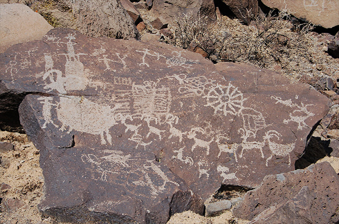
Fig. 2. Coso Representational rock art, Coso Style sheep, bowmen, and more ancient,
patinated abstract and geometric petroglyph elements.
Ecological and Cultural Significance of Burning Beargrass Habitat on the Olympic Peninsula, Washington
Daniela Joy Shebitz, Sarah Hay den Reichard and Peter W Dunwiddie. 2009. Ecological and Cultural Significance of Burning Beargrass Habitat on the Olympic Peninsula, Washington. Ecological Restoration Vol, 27. No. 3, 2009.
Full text [here]
Selected Excerpts:
ABSTRACT
To conserve or restore culturally significant plants, one must consider the important role that indigenous land management techniques have played in maintaining habitats of those species. Beargrass (Xerophyllum tenax) is a basketry plant used by Native Americans and is reportedly declining in traditional gathering sites. Many low-elevation beargrass sites on the Olympic Peninsula in Washington were maintained as savannas and wetland prairies through anthropogenic burning prior to European settlement. This study measures short-term (1 and 2 y) effects of reintroducing prescribed burning (both low and high severity) and manual clearing on beargrass growth and reproductive success—flowering, vegetative reproduction, and seedling establishment. High-severity fire led to a significant increase in beargrass seedling establishment and vegetative reproduction over two years but a decline in beargrass cover. Low-severity fire also decreased beargrass cover, but did not significantly affect shoot production or seedling establishment. In areas where vegetation and coarse woody debris were manually cleared, beargrass cover decreased, while shoot production and flowering increased. Neither low-severity fires nor clearing plots affected beargrass seedling establishment. Results indicate that fire is a useful tool for enhancing low-elevation beargrass populations in this region.
Introduction
The persistence of many indigenous traditions is dependent upon the availability of culturally significant resources {Anderson 1996a, 1996b, 2005). Baskets made from local plants, for example, strengthen cultures by preserving traditions, reinforcing communities, and providing income (Shebitz and Kimmerer 2005). Indigenous basketmakers throughout the United States, however, have reported a decline in abundance and quality of basketry plant material at historic gathering sites. The absence of traditional burning over the past century is a potential cause for the decline in abundance of some basketry plant species, including deergrass (Muhlenbergia rigens) (Anderson 1996b), sweetgrass (Anthoxanthum nitem [=Hierochloe odorata]) (Shebitz and Kimmerer 2004), and beargrass (Xerophyllum tenax) (Hunter 1988, Rentz 2003, Shebitz 2005).
Historic Anthropogenically Maintained Bear Grass Savannas of the Southeastern Olympic Peninsula
David Peter and Daniela Shebitz. 2006. Historic Anthropogenically Maintained Bear Grass Savannas of the Southeastern Olympic Peninsula. Restoration Ecology Vol. 14, No. 4, pp. 605–615
Full text [here]
Selected Excerpts:
Abstract:
This paper documents the existence and character of a little known fire-maintained anthropogenic ecosystem in the southeastern Olympic Peninsula of Washington State, U.S.A. Due to cessation of anthropogenic burning, there is no longer an intact example of this ecosystem. We present evidence from Skokomish oral tradition, historical documents, floral composition, tree-ring analysis, stand structure, and site potential to describe former savanna structure and function. We believe this system was a mosaic of prairies, savannas, and woodlands in a forest matrix maintained through repeated burning to provide culturally important plants and animals. The overstory was dominated by Douglas-fir (Pseudotsuga menziesii). Bear grass (Xerophyllum tenax) likely was a dominant understory component of the savannas, woodlands, and prairie edges. These lands grew forests in the absence of anthropogenic burning. Wide spacing of older trees or stumps in former stands and rapid invasion by younger trees in the late 1800s and early 1900s suggest a sudden change in stand structure. Shade-intolerant prairie species are still present where openings have been maintained but not in surrounding forests. Bark charcoal, fire scars, tree establishment patterns, and oral traditions point to use of fire to maintain this system. A common successional trajectory for all these lands leads to forested vegetation. These findings suggest that frequent application of prescribed burning would be necessary to restore this ecosystem.
Introduction
Some anthropogenically maintained ecosystems owe their character to cultural burning and are inherently unstable when management practices change. Fire-dependent habitats that were maintained through burning by Native Americans include the prairies and savannas of western Washington State, U.S.A. Although these habitats were common in the region prior to European settlement (Jones 1936; Norton 1979; Leopold and Boyd 1999), their former extent in the southeastern Olympic Peninsula is not well known. …
Prior to European settlement, anthropogenic burning in many areas was regular, constant, and long term, causing cumulative effects reflected in current plant communities and species distributions (Pyne 1982; Anderson 1996, 2005; Boyd 1999). Prairie and savanna flora and fauna were integral components of diets, medicines, baskets, and rituals of local tribes (Norton 1979). The most significant sources of complex carbohydrates in the diets of Olympic Peninsula tribes came from bulbs and rhizomes found in prairies and savannas. Bracken fern (Pteridium aquilinum (L.) Kuhn) and Common camas (Cammasia quamash (Pursh) Greene) were commonly used by the Skokomish and other native peoples in wetter Washington coastal environments (Gunther 1974; Norton 1979; Deur 2000). Berries growing in prairie forest ecotones were important sources of sugars and vitamins. Bear grass, used in Skokomish basketry and burial ceremonies (Gunther 1974; Shebitz 2005), also grew historically on the periphery of prairies (B. Miller, Skokomish Tribe, 2004, personal communication). According to Skokomish oral tradition, fire intervals were determined, in part, to maximize production of Trailing blackberry (Rubus ursinus Cham. and Schlecht) (B. Miller, Skokomish Tribe, 1996, personal communication). Prairies and savannas provided important Blacktail deer (Odocoileus hemionus) and Elk (Cervus canadensis) winter range, and were convenient places to hunt (Kruckeberg 1991; B. Miller, Skokomish Tribe, 2004, personal communication). …
Our objective is to provide evidence for the historic existence and character of an anthropogenically managed savanna ecosystem on the southeastern Olympic Peninsula of Washington as mixed prairie forest areas supporting extensive patches of bear grass. We compare data from two vegetation types identified on 1929 aerial photographs as savanna and matrix forests and describe forest invasion of savannas in the late 1800s. We interpret current vegetation in light of tree-ring analysis, fire history, and native oral traditions to reconstruct former savanna vegetation. We discuss our results in terms of site potential, cultural influence, and fire history. This information is assisting current efforts of the Olympic National Forest (ONF) in restoring savannas to the area. …