North Fork Complex/Rattle Fire (Repost)
Location: 10 miles NE of Steamboat, Lane Co., OR
Specific Location: S Fork Cedar Creek, trib to Steamboat Creek, trib to N Umpqua River, Umpqua NF, Lat 43° 27′ 21″ Lon 122° 38′ 25″
Date of Origin: 08/13/2008
Cause: lightning
Situation as of 10/08/2008 at 4:00 PM
Personnel: 26
Size: 20,226 acres (Rattle Fire 19,775 acs; North Fork Fire 451 acs and 100% contained)
Percent contained: 90%
Costs to Date: ~$30 million ($21,057,784 reported)
Transfer fire back to local unit at 1800 and close out with forest.
***************
Situation as of 10/06/2008 at 5:00 PM
Personnel: 112
Size: 20,226 acres (Rattle Fire 19,775 acs; North Fork Fire 451 acs and 100% contained)
Percent contained: 90%
Costs to Date: ~$30 million ($20,955,000 reported)
Continued demob of resources and equipment. Stump holes and snags smoldering.
***************
Situation as of 10/05/2008 at 4:30 PM
Personnel: 131
Size: 20,226 acres (Rattle Fire 19,775 acs; North Fork Fire 451 acs and 100% contained)
Percent contained: 90%
Costs to Date: ~$29.8 million ($20,760,000 reported)
Extensive demob continues. Chipping and road work.
***************
Situation as of 10/04/2008 at 3:00 PM
Personnel: 170
Size: 20,226 acres (Rattle Fire 19,775 acs; North Fork Fire 451 acs and 100% contained)
Percent contained: 90%
Costs to Date: ~$29.6 million ($20,580,000 reported)
Approx 2″ of rain has been received over most of the fire area from this frontal passage. Extensive rehab on line and backhaul or equipment.
Boulder Creek Wilderness 90% burned. Click map for larger image.
***************
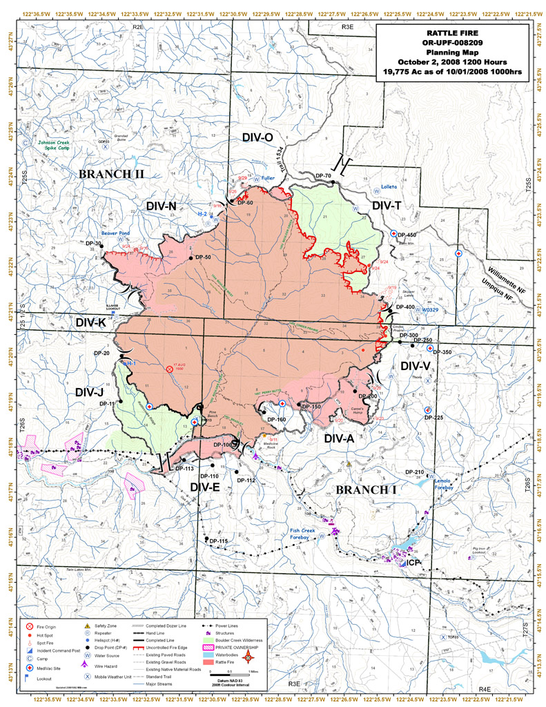
Situation as of 10/02/2008 at 6:00 PM
Personnel: 310
Size: 20,226 acres (Rattle Fire 19,775 acs; North Fork Fire 451 acs and 100% contained)
Percent contained: 70%
Costs to Date: ~$29.1 million ($20,100,000 reported)
Fire size increased by ~110 acres yesterday. A road closure order was put into effect for Forest Road 5851 on the Willamette National Forest.
Rain on the fire allowed crews to advance containment lines around the slop-over to the N. Fire behavior was moderated due to the weather. Significant rain is forecasted for the area over the next few days and fire behavior is expected to decrease.
***************
Situation as of 10/01/2008 at 6:00 PM
Personnel: 340
Size: 20,113 acres (Rattle Fire 19,662 acs; North Fork Fire 451 acs and 100% contained)
Percent contained: 65%
Costs to Date: ~$28.8 million ($19,760,000 reported)
Fire size increased by ~660 acres yesterday. Indirect line is being built north of the Boulder Creek Wilderness boundary along Bulldog Trail 1534 and Road 5851. Plans have been developed to burn out this area if conditions warrent. Additional resources have arrived to help with this effort.
The fire continues to move northward within and beyond the Boulder Creek Wilderness Area. Multiple spots across the north contingency line. Fire now in the Willamette National Forest.
***************
Situation as of 09/30/2008 at 6:00 PM
Personnel: 301
Size: 19,457 acres (Rattle Fire 19,006 acs; North Fork Fire 451 acs and 100% contained)
Percent contained: 65%
Costs to Date: ~$28.5 million ($19,450,000 reported)
Fire size increased by ~170 acres yesterday. Fire intensity has increased and the fire has moved steadily to the north and east. It has crossed the 3810 road at several locations. [The 3810 Rd. is N of the wilderness boundary at the ridgetop separating the Umpqua and Willamette watersheds. - Ed].
The fire continues to move northward within and beyond the Boulder Creek Wilderness Area. The spot across the 3810 road yesterday was 13 acres. Today there were multiple spots across the north contingency line, the largest estimated at 50 acres. These spots are near the boundary of the Willamette National Forest.
***************
Situation as of 09/29/2008 at 6:00 PM
Personnel: 305
Size: 19,289 acres (Rattle Fire 18,838 acs; North Fork Fire 451 acs and 100% contained)
Percent contained: 65%
Costs to Date: ~$28.2 million ($19,200,000 reported)
Fire size increased by ~450 acres yesterday. Forest closures remain in place around the fire area. Crews continued burnout operations along the northwest perimeter.
The SE and SW corners of the fire are in a mop-up and patrol status. Additional support has been placed in this area due to the winds and the proximity to the Dry Creek community. The burnout along the N flank will continue to keep just in front of the fire edge. Rehabilitation continues on the S and E flanks of the fire. Scouting for contingency lines to the N of the fire is taking place.
***************
Situation as of 09/28/2008 at 6:00 PM
Personnel: 414
Size: 18,841 acres (Rattle Fire 18,390 acs; North Fork Fire 451 acs and 100% contained)
Percent contained: 65%
Costs to Date: ~$27.8 million ($18,800,000 reported)
Fire size increased by ~130 acres yesterday. Forest closures remain in place around the fire area. Crews continued burnout operations along the northwest perimeter.
Red Flag Warning for Monday.
Fire behavior has increased with the continued dry hot weather. Jim Valentine’s Type 3 organization has taken over the fire as of 0630 today. ICP has been moved to the Toketee Ranger Station.
***************
Situation as of 09/27/2008 at 6:00 PM
Personnel: 562
Size: 18,713 acres (Rattle Fire 18,262 acs; North Fork Fire 451 acs and 100% contained)
Percent contained: 65%
Costs to Date: ~$27.4 million ($18,400,000 reported)
Fire size increased by ~200 acres yesterday. Forest closures remain in place around the fire area. Crews continued burnout operations along the northwest perimeter.
HIGH PRESSURE WILL STRENGTHEN OVER THE REGION LEADING TO WARMER AND DRIER CONDITIONS. IN PARTICULAR UNSEASONABLY WARM DRY AND UNSTABLE CONDITIONS WILL EXIST SUNDAY AND MONDAY AFTERNOON ALONG WITH POOR RIDGETOP RECOVERIES THROUGH MONDAY NIGHT, ESPECIALLY OVER THE CASCADES AND SISKIYOUS. ON MONDAY AFTERNOON ISOLATED THUNDERSTORMS ARE FORECAST NEAR AND
EAST OF THE CASCADES.
Transition with a Type 3 organization began today. Transfer of command will occur at 630 on 9/28 to a local Type 3 organization (Valentine). PNW2 Type 1 IMT (Hoff) has been managing the fire for 9 days, but now they are calling it quits. The fire is still actively growing and fire weather warnings are in effect.
***************
Situation as of 09/26/2008 at 6:00 PM
Personnel: 654
Size: 18,529 acres (Rattle Fire 18,078 acs; North Fork Fire 451 acs and 100% contained)
Percent contained: 62%
Costs to Date: ~$26.9 million ($17,885,672 reported)
Fire size increased by ~40 acres yesterday.
Forest closures remain in place around the fire area.
Crews began small burnout operations along the northwest perimeter due to fire growth and hot/dry weather conditions.
HIGH PRESSURE WILL STRENGTHEN OVER THE REGION LEADING TO WARMER AND DRIER CONDITIONS. IN PARTICULAR UNSEASONABLY WARM DRY AND UNSTABLE CONDITIONS WILL EXIST SUNDAY AND MONDAY AFTERNOON ALONG WITH POOR RIDGETOP RECOVERIES THROUGH MONDAY NIGHT, ESPECIALLY OVER THE CASCADES AND SISKIYOUS. ON MONDAY AFTERNOON ISOLATED THUNDERSTORMS ARE FORECAST NEAR AND
EAST OF THE CASCADES.
***************
Situation as of 09/25/2008 at 6:00 PM
Personnel: 723
Size: 18,490 acres (Rattle Fire 18,039 acs; North Fork Fire 451 acs and 100% contained)
Percent contained: 60%
Costs to Date: ~$26.4 million ($17,382,372 reported)
Fire size increased by ~500 acres yesterday.
Forest closures remain in place around the fire area.
The fire continues to move slowly northward within the Boulder Creek Wilderness Area. The roads on the Northern flank have been prepped for containment, or burnout, if necessary. Small scale burnout conducted on SE flank.
90% of Boulder Creek Wilderness has been burned so far.
***************
Situation as of 09/24/2008 at 6:00 PM
Personnel: 808
Size: 18,003 acres (Rattle Fire 17,552 acs; North Fork Fire 451 acs and 100% contained)
Percent contained: 58%
Costs to Date: ~$26 million ($17,041,400 reported)
Fire size increased by ~400 acres yesterday.
Forest closures remain in place around the fire area. The Stage 1 evacuation level was lifted for all residences at 1800.
The fire continues to move slowly northward within the Boulder Creek Wilderness Area. The roads on the Northern flank have been prepped for containment, or burnout, if necessary.
***************
Situation as of 09/23/2008 at 6:00 PM
Personnel: 920
Size: 17,602 acres (Rattle Fire 17,151 acs; North Fork Fire 451 acs and 100% contained)
Percent contained: 55%
Costs to Date: ~$25.3 million ($16,333,745 reported)
Fire size increased by ~6 acres yesterday.
Forest closures remain in place around the fire area. The fire continues to move slowly northward within the Boulder Creek Wilderness Area.
***************
Situation as of 09/22/2008 at 6:00 PM
Personnel: 1,075
Size: 17,596 acres (Rattle Fire 17,145 acs; North Fork Fire 451 acs and 100% contained)
Percent contained: 48%
Costs to Date: ~$24.7 million ($15,693,993 reported)
Fire size increased by ~250 acres yesterday.
Forest closures remain in place around the fire area. Fire behavior moderated with cooler temperatures and higher relative humidities. Crews continue utilizing a combination of direct and indirect attack on the eastern and northwestern perimeters. Burnout operations were limited due to yesterday’s rain showers. The fire continues to move slowly northward within the Boulder Creek Wilderness Area.
***************
Situation as of 09/21/2008 at 6:00 PM
Personnel: 1,035
Size: 17,358 acres (Rattle Fire 16,907 acs; North Fork Fire 451 acs and 100% contained)
Percent contained: 48%
Costs to Date: ~$23.6 million ($14,662,359 reported)
Fire size increased by ~2,700 acres in the last two days.
Highway 138 was opened at approximately 1400. Reduced speeds through the fire area are in place. Evacuations levels were lowered to a Stage 1 in the following areas: Slide Creek, Dry Creek, Toketee School, PacifiCorp Operations Center. Forest closures remain in place around the fire area.
Fire behavior moderated with cooler/wet weather. Burnout operations were limited due to weather conditions. The fire continues to move slowly northward within the Boulder Creek Wilderness Area.
***************
Situation as of 09/19/2008 at 6:00 PM
Personnel: 1,086
Size: 15,772 acres (Rattle Fire 14,227 acs; North Fork Fire 451 acs and 100% contained)
Percent contained: 28%
Costs to Date: ~$21 million ($12,338,268 reported)
Fire size increased by ~1,100 acres yesterday.
A four mile section of Highway 138 remains closed between Copeland Creek and Slide Creek.
Fire is continuing to move N within the Boulder Creek drainage and E out of the Boulder Creek Wilderness towards the headwaters of Slide Creek. Active fire runs with torching and short range spotting. Approx 3/4ths of the 19,000 acre Boulder Creek Wilderness now incinerated. Vaunted old-growth, spotted owl forest now charred snags.
Remaining line improvement is unknown due to confusion over suppression goals. Anticipate possibility of building 4 miles of new line. Line constructed/improved to date is 25 miles.
PNW2 Type 1 IMT (Hoff) replaced ORCA Type 2 IMT (Paul) at 0600 on 9/20/08.
***************
Situation as of 09/18/2008 at 6:00 PM
Personnel: 976
Size: 14,678 acres (Rattle Fire 14,227 acs; North Fork Fire 451 acs and 100% contained)
Percent contained: 28%
Costs to Date: ~$20 million ($11,022,276 reported)
Fire size increased by ~3,000 acres yesterday.
A four mile section of Highway 138 remains closed between Copeland Creek and Slide Creek. Hazard tree removal has been completed along Highway 138 in preparation for reopening following debris removal by ODT. Fire South of Highway 138 has control lines established on all flanks and is in patrol status.
Fire is continuing to move N within the Boulder Creek drainage and E out of the Boulder Creek Wilderness towards the headwaters of Slide Creek. Active fire runs with torching and short range spotting. Approx 2/3rds of the 19,000 acre Boulder Creek Wilderness now incinerated. Vaunted old-growth, spotted owl forest now charred snags.
Remaining line improvement is unknown due to confusion over suppression goals. Anticipate possibility of building 4 miles of new line. Line constructed/improved to date is 25 miles.
Hoff’s ICT 1 is shadowing Paul’s ICT 2 through 9/19/08 and will transition at 0600 on 9/20/08.
***************
Bulletin: Significant fire growth today (09/18). InciWeb reported 14,227 acres for the Rattle Fire at 2 PM.
Situation as of 09/17/2008 at 6:00 PM
Personnel: 929
Size: 11,658 acres (Rattle Fire 11,207 acs; North Fork Fire 451 acs and 100% contained)
Percent contained: 30% (reported)
Costs to Date: ~$19 million ($10,091,514 reported)
Estimated date of containment: 09/30/2008
Fire is continuing to move E out of the Boulder Creek Wilderness boundary. Fire continues to back into the Singe and Reynolds Creek drainages. Fire is well established on W slopes of Steamboat drainage and will continue until contained. Fire has also spotted into Medicine Creek. Fire is plume dominated with active spotting.
***************
Situation as of 09/16/2008 at 6:00 PM
Personnel: 936
Size: 7,475 acres (Rattle Fire 7,024 acs; North Fork Fire 451 acs and 100% contained)
[That is clearly an underestimate. 13,000 acres is closer to the truth. -Ed]
Percent contained: 25% (reported, 10% more honestly)
Costs to Date: $9,117,852 million (reported but the truth is closer to $18 million)
Estimated date of containment: 09/30/2008
Without a doubt the ORCA Type 2 IMT (Paul) are grossly understating every fire statistic. Ken Paul’s team cannot be trusted to tell the truth. They are doing a lousy job of fighting the fire, too, unless their goal is to burn as much of the Umpqua NF as possible, in which case they are succeeding according to plan.
According to MODIS satellite sensing the Rattle Fire gained ~6,000 acres yesterday. It has spread E out of the Boulder Creek Wilderness, has crested Thorn Mountain and is in the Deer Creek drainage due N of Toketee Falls.
Plume dominated extreme fire behavior was observed unofficially but not reported in the 209.
***************
Situation as of 09/15/2008 at 6:00 PM
Personnel: 927
Size: 6,184 acres (Rattle Fire 5,733 acs; North Fork Fire 451 acs and 100% contained)
Percent contained: 25%
Costs to Date: ~$17.4 million (North Fork Fire, $5,855,982; Rattle Fire, ~$11.5 million)
Estimated date of containment: 09/30/2008
Costs reported by ORCA Type 2 IMT (Paul) are grossly understated. They fail to account for the $3.1 million spent on the Rattle Fire before ORCA was assigned, and fail to include the $5.9 million spent on the other fires in the North Fork Complex.
Fire gained ~2,000 acres yesterday.
Plume dominated fire activity occuring within the Spring Creek and Onion Creek drainages of the Boulder Creek Wilderness and is threatening to cross to the E side of the Boulder Creek drainage. Fire has crossed the head of Singe Creek and Reynolds Creek. Fire has spotted over the wilderness boundary on the W flank as well as E and S flanks.
Extreme fire behavior with torching, running, and long range spotting. Flame lengths of 100 feet were observed early in the burn period. Plume dominated fire in both the A.M. and P.M.
***************
Situation as of 09/14/2008 at 6:00 PM
Personnel: 998
Size: 4,473 acres (Rattle Fire 3,801 acs; North Fork Fire 451 acs and 100% contained)
Percent contained: 30%
Costs to Date: ~$16.2 million (North Fork Fire, $5,855,982; Rattle Fire, ~$10.3 million)
Estimated date of containment: 09/30/2008
Costs reported by ORCA Type 2 IMT (Paul) are grossly understated. They fail to account for the $3.1 million spent on the Rattle Fire before ORCA was assigned, and fail to include the $5.9 million spent on the other fires in the North Fork Complex.
A voluntary evacuation notice continues to remain in place for 2 Slide Creek residences, and a voluntary evacuation was issued for Wilson Creek. PacifiCorp is in the process of de-energizing the 39 and 46 line.
Fire gained ~220 acres yesterday.
Plume dominated fire activity within the Boulder Creek Wilderness.
***************
Situation as of 09/13/2008 at 6:00 PM
Personnel: 1,018
Size: 4,252 acres (Rattle Fire 3,801 acs; North Fork Fire 451 acs and 100% contained)
Percent contained: 20%
Costs to Date: ~$15.2 million (North Fork Fire, $5,855,982; Rattle Fire, ~$9.3 million)
Estimated date of containment: 09/30/2008
Costs reported by ORCA Type 2 IMT (Paul) are grossly understated. They fail to account for the $3.1 million spent on the Rattle Fire before ORCA was assigned, and fail to include the $5.9 million spent on the other fires in the North Fork Complex.
A voluntary evacuation notice continues to remain in place for 2 Slide Creek residences, and a voluntary evacuation was issued for Wilson Creek. PacifiCorp is in the process of de-energizing the 39 and 46 line.
Fire gained ~340 acres yesterday.
Interior spread along Rattlesnake Ridge into Eagle Creek is being checked by use of heavy helicopters and hotspotting tactics. [That was the method used by NWO Type 2 IMT (West) before they were kicked off the fire for doing suppression.]
***************
Situation as of 09/12/2008 at 6:15 PM
Personnel: 944
Size: 3,912 acres (Rattle Fire 3,461 acs; North Fork Fire 451 acs and 100% contained)
Percent contained: 16%
Costs to Date: ~$14,151,150 (North Fork Fire, $5,855,982; Rattle Fire, $8,295,165)
Estimated date of containment: 09/30/2008
Costs reported by ORCA Type 2 IMT (Paul) are grossly understated. They fail to account for the $3.1 million spent on the Rattle Fire before ORCA was assigned, and fail to include the $5.9 million spent on the other fires in the North Fork Complex.
A voluntary evacuation notice continues to remain in place for 2 Slide Creek residences, and a voluntary evacuation was issued for Wilson Creek. PacifiCorp is in the process of de-energizing the 39 line.
Fire gained ~200 acres yesterday. Increasing surface fire spread, short range spotting, and isolated torching.
***************
Situation as of 09/11/2008 at 6:00 PM
Personnel: 899
Size: 3,723 acres (Rattle Fire 3,272 acs; North Fork Fire 451 acs and 100% contained)
Percent contained: 15%
Costs to Date: $13,242,834 (North Fork Fire, $5,855,982; Rattle Fire, $7,386,852)
Estimated date of containment: 09/30/2008
A four mile section of Highway 138 remains closed between Copeland Creek and Slide Creek. A voluntary evacuation notice continues to remain in place for 2 Slide Creek residencies. No report on Rock Creek power station.
Fire gained 572 acres yesterday. Interior spread along Rattlesnake Ridge into Eagle Creek is being checked by use of heavy helicopters and hotspotting tactics. Suppression efforts continue along SW flank in DIV E. Hotspotting tactics continuing along Rattlesnake Ridge and head of Onion drainage.
***************
Situation as of 09/10/2008 at 6:00 PM
Personnel: 856
Size: 3,318 acres (Rattle Fire 2,867 acs; North Fork Fire 451 acs and 100% contained)
Percent contained: 10%
Costs to Date: $11,918,259 (North Fork Fire, $5,855,982; Rattle Fire, $6,062,277)
Estimated date of containment: 09/30/2008
A voluntary evacuation notice continues in preparation for potential evacuation of structures in the incident area. Highway 138 closed between MP 47 and MP 59.
Increasing surface fire spread, short range spotting, and isolated torching. Soda Spring overrun.
Control lines established on S and E flanks. Preparing for backfire operations.
Interior spread along Rattlesnake Ridge into Eagle Creek is being checked by use of heavy helicopters and limited hand line construction.
No announcement of the desired burn area.
***************
Situation as of 09/09/2008 at 6:00 PM
Personnel: 711
Size: 3,151 acres (Rattle Fire 2,700 acs; North Fork Fire 451 acs and 100% contained)
Percent contained: 10%
Costs to Date: bogus numbers reported, est. true costs at $12.1 million (North Fork Fire, $5,855,982; Rattle Fire, ~$6,300,000)
Estimated date of containment: 09/30/2008
Notification level is currently at 2, preparation for potential evacuation of structures in the incident area. Highway 138 was closed between MP 47 and MP 59.
Active surface fire spread with active backing and lateral spread.
Fire S of Highway 138 has contingency control lines established. Preparing for potential backfire operations.
No word yet on whether the desired burn area will be 80,000 to 100,000 acres, as on the Ukonom, Iron, and Siskiyou Fires in Northern CA. Those target incineration areas were announced in June and achieved in September.
***************
Situation as of 09/08/2008 at 6:00 PM
Personnel: 466
Size: 2,689 acres (Rattle Fire 2,238 acs; North Fork Fire 451 acs and 100% contained)
Percent contained: 10%
Costs to Date: bogus numbers reported, est. true costs at $11.1 million (North Fork Fire, $5,855,982; Rattle Fire, ~$5,300,000)
Notification level is currently at 2, preparation for potential evacuation of structures in the incident area. Highway 138 was closed between MP 47 and MP 59.
Active surface fire spread with active backing and lateral spread.
Fire S of Highway 138 has contingency control lines established. Preparing for potential backfire operations.
No word yet on whether the desired burn area will be 80,000 to 100,000 acres, as on the Ukonom, Iron, and Siskiyou Fires in Northern CA. Those target incineration areas were announced in June and achieved in September.
***************
Situation as of 09/07/2008 at 5:00 PM
Personnel: 372
Size: 2,433 acres (Rattle Fire 1,982 acs; North Fork Fire 451 acs and 100% contained)
Percent contained: 5%
Costs to Date: no update, est. $10 million (North Fork Fire, $5,855,982; Rattle Fire, ~$4,200,000)
State Highway 138 is closed from MP 45 to MP 59. Notification level is currently at 2 in preparation for potential evacuation of structures in the incident area.
Fire burning within and outside of the wilderness. Crews are focusing on spot fires south of the highway and protection of Pacific Corp powerlines and facilities in the area. Additional equipment and crews are being ordered to help in the suppression efforts.
Spring Fire (1996) area has numerous dead snags, thick brush. Fire spread from snag torching and spotting, easterly winds, low humidities. Forecast is for north winds 5 to 15 mph, gusts to 25 to 30 mph in the afternoon.
***************
Situation as of 09/06/2008 at 4:30 PM
Personnel: 190
Size: 1,750 acres (not updated from 09/05)
Percent contained: 0%
Costs to Date: (not updated from 09/05) $8,955,982 (North Fork Fire, $5,855,982; Rattle Fire, $3,100,000)
Fire acreage increased due to extreme fire behavior on 9/5/08. Running wind driven fire with long range spotting across Hwy 138.
Highway 138 was closed between MP 47 and MP 59. Pacific Corp powerlines were de-energized.
The Type 3 Team Team (Lunde) in place for one day was transitioned to a Type 2 Team (Paul).
Preparing for extensive burnouts and wholesale forest incineration as per desires of criminal lunatics in charge of the RR-SNF. I have no idea why West’s Type 2 IMT bailed, except possibly that they wanted no part of destroying Oregon forests. And since they wouldn’t do the dirty deed, they were ordered off.
***************
Situation as of 09/05/2008 at 4:00 PM
Personnel: 210
Size: 1,461 acres (Rattle Fire 1,300 acs; North Fork Fire 451 acs and 100% contained)
Percent contained: 0%
Costs to Date: $8,955,982 (North Fork Fire, $5,855,982; Rattle Fire, $3,100,000)
The fire spotted across Boulder Creek and is burning in the 1996 Spring Fire burn to the southeast, with areas of spotting and upslope runs in brush and timber. Crews were pulled back to the roads in the late afternoon.
Transfer of command took place to Type 3 organization led by Nick Lunde today at
0600.
Note: the NW OR IMT (West) has experience with wilderness fires. They contained the Blueridge Fire last year on Mt. Hood, and the Gnarl Fire this year, also on Mt. Hood. The NW OR IMT (West) knows how to contain these fires. However, they have disengaged and turned fire management over to the local Umpqua NF Type 3 team.
Now the fire is rapidly expanding. In my estimation the NW OR IMT (West) should not have been pulled off this fire until it was under control. Now we shall see how much unecessary damage and expense result from that rash and untimely decision. - Ed
***************
Situation as of 09/04/2008 at 3:00 PM
Personnel: 210
Size: 1,461 acres (Rattle Fire 1,010)
Percent contained: 0%
Costs to Date: $8,855,982 (North Fork Fire, $5,855,982; Rattle Fire, $3,000,000)
With the warmer and dryer weather, there has been a moderate increase in the observed fire behavior. Some open flame has been observed with isolated short runs in the larger more continuous fuels.
The transfer of command to the type 3 organization led by IC Nick Lunde, is scheduled to occur Friday, 9/5/2008 at 0600 hours.
***************
Situation as of 09/03/2008 at 3:00 PM
Personnel: 223
Size: 1,411 acres (Rattle Fire 960)
Percent contained: 0%
Costs to Date: $8,555,982 (North Fork Fire, $5,855,982; Rattle Fire, $2,700,000)
A closure order remains in effect, however several roads were reopened to the public today around the fire area adjacent to the Boulder Creek wilderness area.
The transition to the Type 3 organization led by IC Nick Lunde is scheduled to occur on Friday September 5, 2008 at 0600 hours.
Continued mostly a backing, creeping and smoldering fire, some isolated short runs in larger continuous fuels. Continued to use of type 1 helicopters for bucket work to check the fire spread with the objective of keeping it east of Rattlesnake Ridge and north of Boulder Creek, and away from the Dry Creek community.
***************
Situation as of 09/01/2008 at 3:00 PM
Personnel: 292
Size: 1,396 acres (Rattle Fire 945)
Percent contained: 0%
Costs to Date: $8,101,852 (North Fork Fire, $5,855,982; Rattle Fire, $2,245,870)
The Rattle Fire is 945 acres, and 0% contained. The fire spread seems to have been successfully checked yesterday afternoon to north of Boulder Creek and east of Rattlesnake Ridge by heavy helicopter bucket work. Will continue improving the proposed contingency containment lines. Use the helicopters for reconnaissance and for bucket work to check the fire spread with the objective of keeping it east of Rattlesnake Ridge and north of Boulder Creek.
***************
Situation as of 08/31/2008 at 3:00 PM
Personnel: 383
Size: 1,396 acres (Rattle Fire 945)
Percent contained: 0%
Costs to Date: $7,777,546 (North Fork Fire, $5,855,982; Rattle Fire, $1,921,564)
The Rattle Fire is 945 acres, and 0% contained. Continued backing in the dense timber stand on the north side of Onion Ridge.
The Northwest Oregon Incident Management Team led by IC Carl West was delegated the responsibility for the management of this Incident as of 0600 hours today, 8/31/2008. The Rattle Fire was previously included in the North Fork Complex Incident, but as of 0600 hours today, the Rattle Fire Incident has been separated out and delegated to the NWOIMT. The rest of the North Fork Complex has been delegated back to the local unit. Costs to date include the cost accumulated for the suppression of this incident while it was included in the North Fork Complex.
Assisted the local forest today with IA as rapellors assigned to this Incident were used on a small fire near Mt Thielson. Continued demobilization of resources is planned to “right size” the Incident.
Continue to monitor the mapped decision points for the possible evacuation of the Dry Creek community. Use IR as one of the tools for monitoring the spread of the Fire. Continued reconnaisance of the access trails east of Boulder Creek for possible contingency containment lines, otherwise continued improvement of all proposed indirect containment lines. Continued snag falling along access roads and contingency containment lines where appropriate to address safety issues. Continued road brushing on access roads to increase travel visibility/safety concerns where identified. Use heavy helicopter bucket drops to check the fire spread and keep it east of Rattlesnake Ridge and north of Boulder Creek.
Note: the NW OR IMT (West) has experience with wilderness fires. They contained the Blueridge Fire last year on Mt. Hood, and the Gnarl Fire this year, also on Mt. Hood. The NW OR IMT (West) knows how to contain these fires. They have not resorted to massive burnouts in the past. The Rattle Fire currently has burned less than 4% of the Boulder Creek Wilderness and the weather is cool and wet. There is no reason to incinerate the entire drainage. We sincerely hope and expect that the Rattle Fire will be quickly contained so that massive resource destruction does not occur. - Ed
***************
Situation as of 08/30/2008 at 5:45 PM
Personnel: 410
Size: 1,341 acres
Percent contained: 0%
Costs to Date: $7,428,601 (North Fork Fire, $5,855,982; Rattle Fire, $1,572,610)
The Rattle Fire is 890 acres, and 0% contained. Continued backing in the dense timber stand on the north side of Onion Ridge.
Transition with the Northwest Oregon IMT occurred today.
Continued indirect line preparation in DIV A. Abandoned ridgetop DIV T proposal from Balm Mountain and will use Rd. 3810 flanking the NE side of the fire as DIV T. Rd 3810 flanking the NW side of the fire will become an extension of DIV N. A new division, C, is anticipated that will run north from Old Man Rock up the Boulder Creek drainage. Improve line in all other divisions.
***************
Regarding the discussion above, Balm Mtn. and Rd. 3810 are not shown on this map. They are at least 6 or 7 miles distant from the Rattle Fire. If the Rattle Fire extended all the way to Rd. 3810 it would encompass 25,000 acres and the entirety of the Boulder Creek Wilderness. I hope the Northwest Oregon IMT does not intend to backburn from Rd. 3810. That would increase the fire size 20-fold and destroy nearly 40 square miles of Oregon Cascade forest.
***************
Situation as of 08/29/2008 at 5:30 PM
Personnel: 428
Size: 1,286 acres
Percent contained: 0%
Costs to Date: $7,140,417
The Rattle Fire is 835 acres, and 0% contained. Continued backing in the dense timber stand on the north side of Onion Ridge.
Completed scouting new division (T) and anticipating beginning indirect line construction next operational period. Held transition briefing with incoming Northwest T2
***************
Situation as of 08/27/2008 at 7:00 PM
Personnel: 546
Size: 1,071 acres
Percent contained: 0%
Costs to Date: $6,329,471
The Rattle Fire is 620 acres, and 0% contained. Backing downslope with short uphill runs. Flame lengths occasionally to 4 feet. Indirect line construction in preparation for potential burnout.
***************
Situation as of 08/25/2008 at 5:00 PM
Personnel: 580
Size: 892 acres
Percent contained: 50%
Costs to Date: $5,518,015
Currently working with cooperating agencies and the community of Dry Creek to develop an Evacuation and Protection Plan.
The North Fork Complex is comprised of 7 small IA fires all in control status. The North Fork Fire is 451 acres and 100% contained. The Rattle Fire is 442 acres and 0% contained. Divisions A, J, and N on the Rattle Fire will continue to prep containment lines for possible burnout. Snags continue to be a safety issue.
***************
Situation as of 08/24/2008 at 5:20 PM
Personnel: 575
Size: 728 acres
Percent contained: 40%
Costs to Date: $5,057,809
The North Fork Complex is comprised of 7 small IA fires all in controlled status, the North Fork Fire (451 acres and 90 percent contained) and the Rattle Fire (277 acres and 0 percent contained). Blue Mountain Team in briefed with the Umpqua NF today and assumed
command of the Rattle Fire at 0600 on 8/24/2008.
North Fork Fire continues to have a few smoldering spots far into the interior. Rattle Fire is backing down slope with short uphill runs. Flame lengths to 4 feet. Will continue to scout for indirect line locations using trails and roads, prep containment lines for burnout, and snag falling where needed for safety.
***************
Situation as of 08/22/2008 at 5:15 PM
Personnel: 751
Size: 451 acres
Percent contained: 65%
Costs to Date: $4,124,468
Acreage does not include acres from the IA fires the team is suppressing.
Fire behavior minimal. Fire continues to smolder and creep. Stumps are burning out. Continued mop-up and falling of hazard trees as necessary.
***************
Situation as of 08/21/2008 at 5:00 PM
Personnel: 758
Size: 450 acres (not updated)
Percent contained: 50%
Costs to Date: $3,463,608
2 fires in contained status and 4 fires in controlled status.
***************
Situation as of 08/20/2008 at 5:00 PM
Personnel: 708
Size: 450 acres (not updated)
Percent contained: 37%
Costs to Date: $2,869,832
There are 4 staffed IA fires and 2 IA fires in patrol. On the North Fork Fire, crews will continue to build handline and to install water handling equipment.
***************
Situation as of 08/19/2008 at 5:00 PM
Personnel: 745
Size: 450 acres
Percent contained: 30%
Costs to Date: $2,076,494
Campgrounds along FS Road 38 remain closed.
Seven IA [initial attack] fires are staffed with 10 more IA fires to be located and staffed. The IA fires are actively spreading requiring ground and air resources to check spread.
Direct line construction where needed, installing water handling equipment on all divisions, and beginning mopup. IA Group will continue to take action on all new starts and continue with appropriate containment actions.
***************
Situation as of 08/18/2008 at 8:00 PM
Personnel: 718
Size: 450 acres
Percent contained: 20%
Costs to Date: $1,249,398
Minimal fire activity today, 8/18/2008 in main fire. 2 initial attack fires started were staffed with 5 more fires still to be staffed, but fires are not growing appreciably. There was significant direct containment line established around the perimeter of the North Fork Fire. Red flag warnings are currently in effect for the fire area due to lightning and high winds.
***************
Situation as of 08/17/2008 at 6:00 PM
Personnel: 451
Size: 400 acres
Percent contained: 0%
Road closures established 8/17/08 in Steamboat drainage. Forest Service Road 38 in the Steamboat Drainage is closed, and campgrounds along FS Road 38 have been evacuated.
Late afternoon lighting storm has started numerous new fires in the Initial Attack area of the IMT. One 3-5 acre fire (Incident No. S08103) in the Team IA boundary area will be contained the evening of 8/17/08. More thunderstorms expected.
***************
Situation as of 08/16/2008 at 6:00 PM
Personnel: 217
Size: 250 acres
Percent contained: 0%
Type 2 IMT ordered and assumed command 8/16/08 at 18:00.
***************
Situation as of 08/15/2008 at 8:00 PM
Personnel: 217
Size: 150+ acres
Percent contained: 2%
The fire is moving in a NE direction, and is expected to grow to 150 acres by the end of the day 8/15/08. Lost control lines today with some spotting and single tree torching. Due to the steep, rugged terrain there are concerns of lack of safety zones. Fuels are very dry and there is a potential for thunderstorms for the next several days. Three road closures are in effect.
by bear bait
Remarkable, isn’t it? The Pine Bench is an anthropogenic forest, yet it is the reason the area was declared untrammeled wilderness!
Those old-growth pine trees would not be there except for human tending. Pine nuts were high protein, high fat food. The cambiums were sweet chewing gum. People sowed those seeds and tending those stands for hundreds of years.
Then racist eco-crazies decided that the people who did all that never existed, and that the pines sprouted up there in a pure pine stand naturally, even though the evidence for human involvement is overwhelming.
And so they declared it a dehumanized free fire zone and at the first opportunity burned it but good. Is that nuts or what?
I hope your friend is right and that some of those heritage pines survived. If they did, it was by accident, and the next fire will roast them dead (if the pine beetles that infest the stands following this fire don’t kill them first).
There are other such old-growth pine patches in the westside Cascades. Jim’s Creek, for example. Quite extraordinary to find a ponderosa pine stand in the middle of an ocean of Douglas-fir. Nothing about the soil precludes D-fir; in fact, they are sprouting up underneath the pines. Nope, the pines are there for a reason, a very human reason, because human beings put them there.

So I called a hunting buddy, to find out if we are going scouting, and his lady said he was off fighting fire. Holy crap, I thought, at 68 what is he doing out on a fire? He is a guy who can drive anything, with some skill, so I let my fears slide. I finally got a hold of him today, at home, sleeping. His Rattle Fire duty is he is driving a water wagon, and he washes off the vehicles coming off some spur road, due to a weed that is known to exist there.
If the prissy know-it-all dipwads who run that outfit today were worth their salt, they would have sprayed out the weed long ago THAT IS ON THE ROAD. So now they have a fire, and a truck at who knows how much an hour, is contracted to position itself at the spur junction and wash down the outbound rigs. So where does that seed go? Down a culvert and into the creek and off to heaven knows where!
He did say a lot of what he has seen is understory burning, although he thinks there were some real hot spots from the earlier fire that cooked. He said that a lot of the snags from the last fire are now gone, and the brush that grew up is gone, too. The Pine Bench trees were so well spaced, and no limbs for a hundred feet he didn’t think they should have been killed by fire through them , but who knows at this time. And for those of you who can’t add one and one to get two, that pine bench of a solid Ponderosa stand is what is called an anthropogenic forest. Quite old, and there because it was tended by people before Europeans. That is not PPine site, other than south slope. And no others like it at the elevation on the west side of the Pacific Crest trail. That is the purpose of the pocket wilderness that is there. Historical reference to those who came before. Their mark on the landscape in the form of lasting vegetation.
Few fight fire. Most are some sort of support for the few that do get near flame. Pays as well, and not a lot of physical strain. And good for the pocket book. My buddy has fought weeds at a fire. Not very romantic or much of a story to tell grandkids.