Little Beaver Complex Let It Burn Fire
Location: 26 mi W of Stanley, BOISE NF, Boise Co. ID
Specific Location: Bernard Lake, Lat 44° 26´ 31″ Lon 115° 31´ 19″
Date of Origin: 07/28/2010
Cause: Lightning
Situation as of 10/07/2010 3:00 pm
Personnel: 0
Size: 7,298 acres
Percent Contained: 0%
Costs to Date: $2,560,000
The Top Notch fire had lots of activity through weekend with running and group torching. The area received precipitation starting last Sunday through yesterday for about 0.68″. Last Sunday also released crew and completed IR which may be the last perimeter unless have more activity. Acres: Boise National Forest 2036. Salmon-Challis,Frank Church Wilderness 5262.
**************
Situation as of 09/28/2010 4:45 pm
Personnel: 30
Size: 6,653 acres
Percent Contained: 0%
Costs to Date: $2,557,000
Commitment of resources to both the Little Beaver Complex and Whitehawk Complex. Assigning the same IC to both complexes. The Boise IHC will be monitoring and working on both as needed. Active fire behavior and expect it to continue with the projected weather.
**************
Situation as of 09/09/2010 2:45 pm
Personnel: none
Size: 6,373 acres
Percent Contained: 0%
Fire added 435 acres on Tuesday 9/7 due to higher temperatures and very low humidities. The fire is still within the 45,000 acre target area.
**************
Situation as of 09/03/2010 3:15 pm
Personnel: 22
Size: 5,350 acres
Percent Contained: 0%
Costs to Date: $2,500,000
***************
Situation as of 08/25/2010 4:15 pm
Personnel: reported number is wrong
Size: 5,350 acres
Percent Contained: 0%
Costs to Date: reported amount is wrong
On Aug 19 the decision was made to forego any fire reports (209’s) because the fire was “inactive”. Since then this fire has blown up and grown by a third.
Now the fire making some significant runs to the north and burning into the Sulfur Creek Area. The local Type 4 team has called in aerial resources to treat the area near the West Fork of Elk Creek, including large airtanker drops on the ridge outside of the wilderness area and SEATS with water within the wilderness. A Type 1 Helicopter was borrowed from the Banner Fire.
A cold front with strong winds is expected to blow through today. This fire could be many tens of thousands of acres in size by tomorrow. We noted back on Aug 4 that this fire could be a possible source for a region-wide fire storm. We also noted that the irresponsible official in charge is infamous Let It Burn forest destroyer Boise NF Forest Supervisor Cecilia Seesholtz.
***************
Situation as of 08/19/2010 3:45 pm
Personnel: 28
Size: 4,053 acres
Percent Contained: 0%
Costs to Date: $2,212,123
No significant activity.
***************
Situation as of 08/14/2010 5:30 pm
Personnel: 118
Size: 4,053 acres
Percent Contained: 0%
Costs to Date: $2,202,123
Patrolled and monitored the southern edge of the fire along FR 579. Continued rehabilitation actions where appropriate. Completed mitigation actions to reduce fire impacts to White Bark Pine stands (firefighters removed adjoining dead subalpine fir and lightly cleared fuel at the base of the trees.). Moved all unnecessary supplies and equipment off the fire. Shadowed/transitioned with the incoming ICT3 to ensure a smooth and effective transfer of command from the IMT2 to the ICT3 at 0600 hours on August 15. Will conduct an IR flight later today with the Lucky Peak helicopter to provide the incoming ICT3 with the latest fire intelligence.
***************
Situation as of 08/13/2010 5:30 pm
Personnel: 166
Size: 4,053 acres
Percent Contained: 0%
Costs to Date: $2,069,217
Continued securing the SE, S and SW fire edge to minimize the potential of fire crossing FR 579 to the south. Began implementation of rehabilitation plan where appropriate. Continued mitigation actions to reduce fire impacts to White Bark Pine stands (potential candidate for listing). Obtained approval of the decision document in WFDSS.
***************
Situation as of 08/11/2010 6:00 pm
Personnel: 251
Size: 4,053 acres
Percent Contained: 0%
Costs to Date: $1,783,833
Completed fuels reduction work in the vicinity of the Deadwood Outfitter facilities and at some cultural resource sites. Continued securing the fire edge along FR 579 to reduce potential of fire crossing the road and moving south. Continued snag mitigation and cold trailing/hot spotting in Divisions Y and Z along the southwest edge of the fire. Obtained approval for the new planning area and 7 additional Management Action Points (MAPs) for the long-term management plan. Worked with Resource Advisors to identify key resource values within the new planning area boundary.
The admission that Resource Advisors (whoever they are) were called upon to identify values at risk confirms that the deliberate Federal action of allowing the fire to burn has significant impact on the environment.
The fire seems to be subdued now, and it is apparently partially contained by (fuel managed) fire lines. The Agency and the NIFC do not wish to admit such explicitly, for political reasons. However, if winds arise and the fire flares up, it could escape the non-containment and do even more damage to the environment. There is a significant risk to leaving fires in Idaho to burn in early August without effective containment.
***************
Situation as of 08/10/2010 6:00 pm
Personnel: 240
Size: 4,053 acres (no update)
Percent Contained: 0%
Costs to Date: $1,576,315
Continued securing portions of the fire edge along FR 579 to reduce potential of fire crossing the road and moving south. Initiated snag mitigation and cold trailing/hot spotting in Divisions Y and Z along the southwest edge of the fire. Continued the revision of long-term management plan by drafting a new planning area boundary and adding additional Management Action Points.
Note: The “long-term management plan” will not be subject to public review. No Section 7 (ESA) consultations done. No Section 106 (NHPA) consultations done. There is no desire or capability to comply with NEPA. Deliberate federal actions are taking place with significant impact to the environment, but without compliance to the laws of the U.S.A.
Federal officials in charge are engaging in criminal activities. They do so with impunity. Unless and until such officials are brought to justice, they will continue to violate the law.
***************
Situation as of 08/09/2010 6:00 pm
Personnel: 240
Size: 4,053 acres (no update)
Percent Contained: 0%
Costs to Date: $1,300,000 (IMT is still collecting data for incident costs so today’s reported costs should be considered to be an initial estimate.)
Secured portions of fire edge along FR 579 with successful burnout operations yesterday coupled with suppression actions — although officially the fire is still 0% contained.
Began revision of long-term management plan, including evaluation of threats to White Bark Pine stands (potential candidate for TandE listing). Deliberate Let It Burn actions promulgated by the Boise NF are thus in clear violation of ESA, NEPA.
***************
Situation as of 08/08/2010 4:00 pm
Personnel: 180
Size: 4,053 acres
Percent Contained: 0% (no explanation for change)
Costs to Date: $400,000
Additional 800 acres deliberately burned.
A Type 2 Incident Management Team (Slavberg) is in command.
The Boise National Forest has a management focus to allow fire to fulfill a natural role in this fire adapted ecosystem.
Desired future condition of the Boise NF.
***************
Situation as of 08/07/2010 6:00 pm
Personnel: 200
Size: 2,850 acres (no update)
Percent Contained: 10%
Desired incineration area: 45,000 acres
Red Flag Warning: thunderstorms, wind gusts to 40 mph
No cost information given.
Fire managers are planning to conduct a burnout operation on the Little Beaver Complex today beginning about noon. The operation will take place on the southwest and south flank of the fire, about 8 miles north of Deadwood Reservoir. The goal is to stop the fires southerly spread by burning fuels that could feed the wildfire under a controlled method.
***************
Situation as of 08/06/2010 6:00 pm
Personnel: 180
Size: 2,850 acres
Percent Contained: 0%
Desired incineration area: 45,000 acres
Red Flag Warning: thunderstorms, wind gusts to 40 mph
Fire tripled in size yesterday. Whoosh whoosh goes the Boise NF. Maybe they can burn up a million acres this month. Maybe the fire can explode on the August winds and burn all the way to Montana.
Or maybe we should fire the idiot arsonist gummit functionaries at the Boise NF instead of our forests.
***************
Situation as of 08/04/2010 5:45 pm
Personnel: 82
Size: 1,000 acres
Percent Contained: 0%
Desired incineration area: 45,000 acres
Fire will be allowed to burn for the next two months. Possible source for a region-wide fire storm. Irresponsible official: Boise NF Supe Cecilia Seesholtz.
No NEPA, no consultations, no public involvement, criminal intent, killer fire. Your rogue crazy Taliban USFS at rampage and ruin.
by N. Pence
It’s the Wildfire Industrial Complex. $2+ million not to suppress, but for burning on purpose without legal sanction at taxpayer expense. Destructive, corrupt, unconscionable.

I am familar with this area because I was TMA on the old Bear Valley Ranger District in 1969 and 1970. We sold two timber sales just south of the fire area for 20MMBF, two more were sold after I left, and there were plans to sell more. The timber sales receipts developed roads for continued timber management. Timber management stopped in the 1990s when the Forest Service destroyed the industry that depended on timber in the area. Timber sales in the area without the industry would not be economic today.
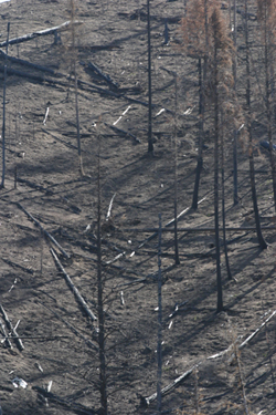
The area the fire is burning in North of the Deadwood River Drainage is in the Frank Church River of No Return Wilderness where fire is the only management tool. The Boise is using “natural” fire to avoid the NEPA process. Much of the area west of the fire has been burned in large “natural” fires starting in 2000. Some of that area would now have ground fuel sufficient to support catastrophic fire.
It is hard for me to understand how they could spend this much money and commit this many resources without suppressing the fire. The White Bark Pine and lodgepole is largely dead and dying from white pine blister rust and bark beetles. Much of the Douglas fir is being attacked by the spruce budworm and the Douglas fir bark beetle. The area is very steep, and rocky with Idaho Batholith soils. It can start snowing anytime after the first of September but Fall can continue to be dry until after mid October. Planned prescribed fire with the NEPA process would be my preferred management considering the current lack of industry. The Boise NF use of “natural” fire is management by accident without the NEPA process, and it flirts with catastrophe. They also spend money with an open pocket book on “natural” fire.