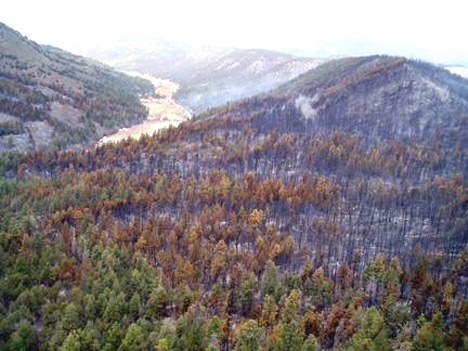
Big Springs Fire
Location: Manzano Mountains, 6 miles W of Tajique, 18 mi E of Valencia, Torrance Co. NM
Specific location: Lat 34° 46′ 15″ Lon 106° 22′ 59″
Date of Origin: 06/24/2008
Cause: Lightning
Situation as of 08/10/08 5:00 AM
Total Personnel: 4
Size: 5,478 acres
Percent Contained: 100%
Costs to Date: $3,327,810
Structures Destroyed: 6 residences , 10 outbuildings
Suppression rehab of the fire perimeter continues. The fire has received a significant amount of precipitation.
***************
Situation as of 07/02/08 8:30 AM
Total Personnel: 245
Size: 5,478 acres
Percent Contained: 100%
Type 1 Management will transfer command to Type 4 Management at 1800, 7/03.
***************
Situation as of 06/30/08 6:00 PM
Total Personnel: 353
Size: 5,580 acres
Percent Contained: 95%
Costs to Date: $2,683,773
***************
Situation as of 06/29/08 6:00 PM
Total Personnel: 417
Size: 5,580 acres
Percent Contained: 85%
Costs to Date: $2,260,000
The fire area received 0.1 to 0.5 inches of rain yesterday evening. Line was completed around the entire perimeter today. Residents were allowed to return home as the evacuations were lifted. Demob of resources has begun. More rain is expected over the fire area this evening.
***************
Situation as of 06/28/08 6:00 PM
Total Personnel: 542
Size: 5,580 acres
Percent Contained: 65%
Costs to Date: $1,750,000
Structures Destroyed: 6 residences , 10 outbuildings
Line was completed around all but 0.5 miles of the perimeter. Completed successful burnout on the south portion of the fire. Torrance County completed the damage assessment for structures lost.
It is expected that evacuations will be lifted tomorrow. Increase in structures lost reflects the results from the damage assessment. No structures were lost this operational period. Fire is beginning to receive rain.
***************
Situation as of 06/27/08 7:00 AM
Total Personnel: 428
Size: 3,500 acres
Percent Contained: 10%
***************
Situation as of 06/24/08 7:00 PM
Total Personnel: 100+
Size: 100 acres
Percent Contained: 0%
Structures Threatened: 60 PRIM , 15 OUTB. Evacuation of the Inlow Youth Camp.
Wed AM Update
We have updated all listed fires from information we gleaned last night. That info was sparse, as might be expected during this major fire bust (of historic proportions).
To access all active fires, click on “Archives_June 2008″ in the righthand sidebar. Scroll to the bottom and click “keep looking”. There are 15 postings per page, and 3 pages of active fires at present.
Wild Bull Fire
Location: 30 miles north of Truth or Consequences, Socorro Co. NM
Specific Location: E of Dusty, Cibola NF, Lat 33° 35´ 28″; Lon 107° 35´ 39″
Date of Origin: 06/18/08
Cause: Lightning
Situation as of 06/22/08 AM
Total Personnel: 0
Size: 122 acres (unconfirmed)
Percent Contained: 0%
This fire has been reported as 122 acres and as 5,000+ acres. At this time we do not know which is correct.
***************
Situation as of 06/21/08 AM
Total Personnel: 0
Size: ~5,000 acres (unconfirmed)
Percent Contained: 0%
Fire is being monitored by air.
Bonney Fire
Location: 31 Miles WSW of Roswell, Lincoln Co. NM
Specific Location: S of Picacho, Lat 33° 17´ 17″; Lon 105° 3´ 23″
Date of Origin: 06/18/08
Cause: Lightning
Situation as of 06/23/08 4:30 PM
Total Personnel: 257
Size: 25,360 acres
Percent Contained: 70%
Costs to Date: $469,000
Subdued fire behavior due to precipitation. Demobilization of existing resources and turn over to Type 3 (local) team.
**************
Situation as of 06/21/08 PM
Total Personnel: 305
Size: 25,329 acres
Percent Contained: 40%
**************
Situation as of 06/20/08 PM
Total Personnel: 221
Size: 14,315 acres
Percent Contained: 13%
Low RH and high temperatures. Large fire growth is being observed.
West Fork Fire
Location: 35 miles West of 28 miles West of Raton, Colfax Co. NM
Specific Location: Caliente Canyon, Lat 36° 52´ 11″; Lon 104° 51´ 5″
Date of Origin: 06/17/08
Cause: Lightning
Situation as of 06/28/08 6:00 PM
Total Personnel: 122
Size: 4,980 acres
Percent Contained: 95%
Costs to Date: $2,481,891
***************
Situation as of 06/26/08 6:00 PM
Total Personnel: 124
Size: 4,980 acres
Percent Contained: 85%
Costs to Date: $2,326,285
***************
Situation as of 06/24/08 6:00 PM
Total Personnel: 405
Size: 4,980 acres
Percent Contained: 75%
Costs to Date: $1,910,000
All five Type 1 IHC will be released tomorrow (6/25/08) A.M. Engines, overhead, and other resources will also begin to downsize.
***************
Situation as of 06/23/08 6:00 PM
Total Personnel: 403
Size: 4,980 acres
Percent Contained: 60%
Costs to Date: $1,650,000
28 acres added to reflect the Mercer Fire acreage, a separate fire in close proximity to the West Fork Fire. Planned actions: patrol, hold, and mop up.
***************
Situation as of 06/21/08 PM
Total Personnel: 242
Size: 4,280 acres
Percent Contained: 20%
Costs to Date: $1,150,000
NAZ Type 2 IMT assumed command of the fire at 0600 this morning.
***************
Situation as of 06/20/08 PM
Total Personnel: 256
Size: 3,800 acres
Percent Contained: 15%
Costs to Date: $760,000
***************
Situation as of 06/20/08 AM
Total Personnel: 230
Size: 3,000 acres
Percent Contained: 5%
Significant ground fire and group torching.
***************
Situation as of 06/19/08 AM
Total Personnel: unreported
Size: 1,100 acres
Percent Contained: 0%
Fire making large pushes and growing significantly in size, spotting, and with significant crowning runs.
Rocky Fire
Location: 35 miles West of Carlsbad, Eddy Co. NM
Specific Location: Lincoln NF, Lat 36° 26´ 52″; Lon 104° 55´ 45″
Date of Origin: 06/18/08
Cause: Lightning
Situation as of 06/23/08 4:00 PM
Total Personnel: 235
Size: 46,478 acres
Percent Contained: 80%
Costs to Date: $1,813,349
Hand ignition within the black line along FS RD 278,FS Rd 67 & FS Rd 521 is complete. Aerial ignition is 100% complete.
***************
Situation as of 06/21/08 7:30 PM
Total Personnel: 233
Size: 43,047 acres
Percent Contained: 35%
***************
Situation as of 06/20/08 7:30 PM
Total Personnel: 230
Size: 40,934 acres
Percent Contained: 20%
Active fire behavior. Significant growth due to dry conditions and wind.
***************
Situation as of 06/19/08 PM
Total Personnel: 184
Size: 20,344 acres
Percent Contained: 0%
The Lincoln National Forest remains closed due to fire danger. Sitting Bull Falls Day Use Area is open for visitation to the falls. All hiking trails remain closed.
***************
Situation as of 06/19/08 AM
Total Personnel: 184
Size: 13,000 acres
Percent Contained: 0%
Costs to Date: $250,000
Fire expanding to NE and SE. Structure protection on two ranches.
***************
Situation as of 06/19/08 AM
Total Personnel: 95
Size: 5,000 acres
Percent Contained: 0%
Flew large airtankers, ordered Type 2 Team. Type 3 (Bryson, IC) to transfer command to Type 2 IMT (Cowie, IC) today.
Dripping Springs Fire
Location: East of Las Cruces at Dripping Springs, Dona Ana Co. NM
Specific Location: Lat 32° 19´ 15″; Lon 106° 34´ 52″
Date of Origin: 06/14/2008
Cause: Human
Situation as of 06/19/08 PM
Total Personnel: 111
Size: 1,735 acres
Percent Contained: 100%
Costs to Date: $480,000
Planned Actions: Mop-up, monitor, and patrol. Dripping Springs and Soledad Canyon recreation areas remain closed.
***************
Situation as of 06/18/08 PM
Total Personnel: 111
Size: 1,950 acres
Percent Contained: 40%
Costs to Date: $400,000
***************
Situation as of 06/17/08 PM
Total Personnel: 135
Size: 1,700 acres
Percent Contained: 40%
Acreage change due to more accurate mapping. Mutual agreement between BLM and US Army will lead to active suppression on military property. Aerial attack today, handcrews tomorrow. ICP has been established at the New Mexico Farm and Ranch Museum.
***************
Situation as of 06/17/08 AM
Total Personnel: 135
Size: 1,980 acres
Percent Contained: 30%
***************
Situation as of 06/16/08
Total Personnel: 135
Size: 1,843 acres
Percent Contained: 30%
8 residences threatened. Burnout operation around structures and homes was successful.
Fire made a significant run up into the Organ Mountains and is currently burning in an inaccessible and prohibited military area (White Sands Missile Range). Torching and running fire was observed in mixed pinyon and juniper.
The Dripping Springs recreation site and Aguirre Springs campground are closed. Soledad Canyon and Dripping Springs Roads are closed to recreationalists and non-residents.
Aggie Fire
Location: 25 miles northwest of Carrizozo, Lincoln Co. NM
Date of Origin: 06/04/2008
Cause: Human
Situation as of 06/08/08
Total Personnel: 28
Size: 1,080 acres
Percent Contained: not reported
***************
Situation as of 06/07/08
Total Personnel: 28
Size: 1,280 acres
Percent Contained: 25%
***************
Situation as of 06/05/08
Total Personnel: 28
Size: 250 acres
Percent Contained: 10%
Red Flag Warning in effect from this afternoon through this evening for the north central mountains across to the northeast and east central plains for strong winds and low humidities. Fire Weather Watch in effect from Sunday afternoon through Sunday evening.
Winds SW 15 to 25 mph, gusts up to 40 mph.
Roger’s Pasture Fire
Location: Mescalero Apache Indian Res., 8 SE of Ruidoso, Otrero Co., NM
Specific Location: near Hale Lake
Date of Origin: 06/04/2008
Cause: Unknown
Situation as of 06/08/08
Total Personnel: 238
Size: 1,498 acres
Percent Contained: 75%
***************
Situation as of 06/07/08
Total Personnel: 298
Size: 1,527 acres
Percent Contained: 40%
Red Flag Warning in effect from this afternoon through this evening for the north central mountains across to the northeast and east central plains for strong winds and low humidities. Fire Weather Watch in effect from Sunday afternoon through Sunday evening.
Winds SW 15 to 25 mph, gusts up to 40 mph.
Officials with the Albuquerque office of the National Weather Service said 60 mph winds were reported at Sierra Blanca Regional Airport Wednesday afternoon and early Thursday. [here]
***************
Situation as of 06/06/08
Total Personnel: 134
Size: 1,500 acres
Percent Contained: 15%
The NM Type 2 IMT took command of the fire at 1630 hrs yesterday. The Mescalero Apache Reservation is under closure.
***************
Current Situation
Total Personnel: 40
Size: 500 acres
Percent Contained: 0%
Summary: Crowning, rapid rate of growth observed. Type 2 IMT (Cervantes) has been ordered.
Red Flag Warning in effect June 5 for strong winds and low relative humidity over much of southern and eastern New Mexico. Wind gusts predicted up to 40 mph. An upper level low pressure front moving through is producing very windy conditions and isolated thunderstorms. Winds are expected to subside by morning as the front moves through the region.
Hennigan Fire
Location: 22 miles SE of Raton, Colfax Co. NM
Specific Location: on the Hennigan Ranch, N slope of Turkey Mtn., SW of Laughlin Peak
Date of Origin: 05/24/2008
Cause: lightning
Situation as of 05/29/08
Total Personnel: 141
Size: 1,800 acres
Percent Contained: 80%
Costs to date: $700,000
***************
Situation as of 05/28/08
Total Personnel: 150
Size: 1,800 acres
Percent Contained: 60%
Costs to date: $550,000
Acreage increase due to backburning. Expected containment 05/29/2008
***************
Situation as of 05/27/08
Total Personnel: 150
Size: 1,200 acres
Percent Contained: 40%
Costs to date: $235,827
Expected Containment: 05/27/08

South Tularosa Fire
Location: 3 miles southeast of Mescalero, Otero Co., NM
Date of Origin: 05/01/08 11:15 AM
Situation as of 05/14/08
Total Personnel: 140
Size: 3,860 acres
Percent contained: 100 % 05/14/08
***************
Situation as of 05/09/08
Total Personnel: 321 (reported Thurs. by AP)
Size: 3,860 acres
Percent contained: 80 %
The Southwest Area Type 1 Incident Management Team will transition to a Type 3 organization with Dave Koch as Incident Commander. Approximately 140 firefighters will remain on the South Tularosa Fire. (reported Wed. by InciWeb)
Red Flag Weather Warning Fri and Sat for high winds S and SW 15 to 20 mph gusting to 40 mph
***************
Situation as of 05/07/08
Total Personnel: 461, transitioning to ~140
Size: 3,860 acres
Percent contained: 70 %
The Southwest Area Type 1 Incident Management Team will transition to a Type 3 organization with Dave Koch as Incident Commander. Approximately 140 firefighters will remain on the South Tularosa Fire.
New Mexico remains on Red Flag Warning for strong winds.
Current Wind Conditions 35 mph SW
Current Temperature 74 degrees
Current Humidity 10 %
***************
Situation as of 05/06/08
Total Personnel: 500
Size: 3,860 acres
Percent contained: 65 %
Red Flag Warning (from noon until 8:00 p.m.) for high winds and dry conditions.
***************
Situation as of 05/05/08
Total Personnel: 468
Size: 3,860 acres
Percent contained: 45 %
Looking down South Tularosa Canyon toward the village of Mescalero.
Credit: Arnie Friedt, InciWeb
***************
Situation as of 05/04/08
Total Personnel: 315
Size: 3,200 acres
Percent contained: 35 %
Update: The South Tularosa Wildland Fire is now listed on InciWeb. The Southwest Area Type I IMT (Vanbruggen) assumed management of the fire at 8 p.m. on Friday, May 2. The fire started in South Tularosa Canyon on Thursday, May 1 and grew quickly due to extremely dry fuel and Red Flag wind conditions. The fire is burning on Mescalero Tribal lands. Air resources available include three on-call air tankers located in Alamogordo and two air attack planes that will monitor the fire activity and one helicopter for incident support. Significant winds are expected to continue throughout this afternoon and may hamper control efforts. Mescalero Tribal lands are under Class 5 Fire Restrictions reflecting the severely dry conditions in the area. Residents and visitors are strongly urged to observe all of the fire restrictions including instructions to smoke only inside buildings and closed vehicles and to be particularly alert during other activities that may start fires. Residents who were asked to evacuate on the night of May 1 have been allowed to return to their homes and the temporary closure of State Highway 244 has been lifted.
Actions: Firefighters on Saturday worked to contain multiple spot fires around the perimeter of the fire on the south and east flanks. Air tankers assisted with one spot fire near State Highway 244 on the north side of the fire.
Fuels: Southwestern edge of the fire includes ganbel oak component. Canopy cover in the timber fuels (ponderosa pine mixed with Douglas-fir) ranges from 60 to 80% and is able to sustain active crown fire within timber fuel types.
Current Wind Conditions: 10-15 mph SE
Current Temperature: 55-60 degrees
Current Humidity: 12-18 %
***************
Situation as of 05/03/08
Total Personnel: ???
Size: 5,000 acres
Percent contained: ???
High winds have been hampering fire fighting efforts. No info or mention of this fire on InciWeb, although this is a Federal agency fire (BIA). No info available at the Southwest Coordination Center either.
Evacuation have been lifted for residents in South Tularosa Canyon and Mudd Canyon. The BIA reported no homes or buildings were lost as of Friday morning, and the fire had moved to an area where it wasn’t threatening any homes.
Highway 244 has been opened.
The cause of the fire is still under investigation.
***************
Situation as of 05/02/08
Total Personnel: ???
Size: 1000+ acres
Percent contained: ???
Summary: Fire is on the Mescalero Apache Indian Reservation. Firefighters report wind driven flames with crowning in timber. Road 244 east of the fire has been closed. Threats to approximately 40 structures and outbuildings.
Trigo Fire
Where: Cibola National Forest, Torrance Co., New Mexico
Specific Location: South of Capilla Peak
Date of Origin: 04/15/2008 at 1555 hrs
Situation as of 05/13/08
Total Personnel: ???
Size: 13,709 acres
Percent Contained: 100% on 05/11/08
Significant Events: Suppression rehab hould be completed by today. Management of the fire is being transferred to a Type 3 (local) IMT. On Monday the Trigo Fire was again tested with record low humidity and strong winds with gusts in excess of 40 mph. Late in the afternoon a small patch of unburned fuel well within the fire perimeter actively burned. This caused calls to the Information Center regarding fire activity. Immediate contact from Operations people in the field confirmed this was not a threat to the containment line.
Winds 5 to 10 mph becoming west 15 to 20 mph in the afternoon with gusts up to 30 mph. Weather mostly cloudy with isolated showers and thunderstorms in the evening, then isolated rain showers after midnight. Chance of precipitation 70 %.
Flash Flood Warning: Communities and homes downstream from the Trigo wildfire will be especially susceptible to flooding from this rain event. This includes the area found between the communities of Manzano and Torreon. Drainages of concern include New, Cuervo, Jaral and Torreon canyons.
***************
Situation as of 05/12/08
Total Personnel: 356
Size: 13,709 acres
Percent Contained: 100%
***************
Situation as of 05/08/08
Total Personnel: 667
Size: 13,709 acres
Percent Contained: 75%
Current Wind Conditions 32 mph W
Current Temperature 72 degrees
Current Humidity 12 %
***************
Situation as of 05/07/08
Total Personnel: 774
Size: 13,680 acres
Percent Contained: 60%
New Mexico remains on Red Flag Warning for strong winds.
FEMA began a preliminary damage assessment on Tuesday in the areas affected by the Trigo Fire. A federal declaration request had been made and accepted by FEMA prior to the blow up 04/30. At that time nine homes had been burned. The count is now ~60 homes destroyed by the Trigo Fire.
***************
Situation as of 05/06/08
Total Personnel: 806
Size: 13,680 acres
Percent Contained: 55%
The evacuation of the Sherwood Forest subdivision has been lifted by Torrance County Civil Authorities. Residents of Sherwood Forest can now enter the subdivision.
Returning residents should be alert for hazards such as concealed pockets of burning embers, burned trees that could fall and downed electric lines.
***************
Situation as of 05/05/08:
Total Personnel 809
Size: 13,680 acres
Percent Contained 50%
An official damage assessment is expected this afternoon.
***************
Situation as of 05/04/08:
Total Personnel 472+
Size 13,790 acres
Percent Contained 35 %
In addition to the 50 homes burned in the blow up, one communications tower (the easternmost facility) has been heavily damaged.
Trigo fire progession map [here] (courtesy InciWeb)
Current Wind Conditions: 10-20 mph NW
Current Temperature: 55 degrees
Current Humidity: 16 %
***************
Situation as of 05/03/08:
Total Personnel 472+
Size 13,790 acres
Percent Contained 35 %
Summary: Torrance County Sheriff’s Department will continue to assess damage today. Currently it appears less than one hundred homes were damaged. As there is active fire still in the area the threat for damage still remains. There is a strong law enforcement presence and no looting is occurring. [here]
Update 11:00 PM: KRQE TV is reporting that 50 homes were burned in the blow up of 05/01. See comments.
***************
Situation as of 05/02/08:
Total Personnel 472
Size 13,790 acres
Percent Contained 35 %
Summary: 600 families evacuated homes in the Torreon and Tajique area. Affected areas include Sufi Campground, Sherwood Forest, Apple Mountain Campground and Ten Pines Road. Residents were asked to evacuate to the Estancia Community Center at Williams Street in Estancia where the American Red Cross has set up.
More than a dozen homes burned yesterday, possibly twice that many. High winds of 30-40 mph with gusts up to 50 mph have made aerial firefighting all but impossible. Heavy smoke obscures views.
***************
BLOW UP !!!
The Trigo Fire has jumped containment lines and more than doubled to 11,360 acres.
Situation as of 05/01/08:
Total Personnel 182
Size 11,360 acres
Percent Contained ???
Cost to date: ???
Summary - Around 3 p.m. yesterday wind gusts up to 50 mph carried an ember approximately ½ mile North of the containment line. Winds were from the Southwest to the Northeast pushing the fire from the New Canyon area toward Capilla Peak and Forest Road 55 (Torreon and Tajique Loop Road).
A Type One team was ordered when the surrounding communities were determined to be in the path of the fire.
At 3:35 p.m. the Torrance County Emergency Office started evacuations in the area of Ten Pines Road, Sherwood Subdivision and later Torreon, SUFI Camp, and the FR 55 Loop Road were included. An Evacuation center is on stand-by at the Estancia Community Center and can be opened at a moments notice. Livestock is being accepted at Torrance County Fairgrounds.
Road closures are at West bound Hwy 55 at Junction 55 and Hwy 337 and Abshire Rd./Ewing Highway.
Two air tankers with a lead plane continued to drop retardant until dark. Firefighters were fighting the fire on the flanks.
The type 3 team will transition to a Type 1 Team (Whitney) today. Additional resources are on order. Torrance County Emergency Management will be holding a meeting today at 1pm in the Estancia Community Center.
Wind: 10-25 mph NW, with gusts to 55 mph
Current Temperature: 57 degrees
Current Humidity: 8-12 %
Estimated Containment Date: 12/29/2008 at hrs.
***************
Situation as of 04/26/08:
Total Personnel 478
Size 4,910 acres
Percent Contained 59%
Cost to date: $4,800,000
Reduced wind allowed firefighters to hold and extend lines Friday. Outlook is good for containment by Monday.
A community meeting is scheduled for this evening at 6:00 PM in the Torreon Community Center. Possible natural resource restorative measures for those affected by the fire will be discussed. The local chapter of the American Red Cross has provided a toll free number (1-800-560-2302) for those needing assistance whose homes were lost or damaged by the Trigo fire.
Congressional staffers, the Mayor of Mountainair and officials from Claunch Soil and Water Conservation District visited ICP today for a tour and briefing. New Canyon Road to Capilla Peak remains closed from the Forest boundary west. Red Canyon campground remains closed, and Forest Road 358 into Bartolo Canyon is blocked due to firefighter activity.
Beehive Fire (8 mi. N of the Trigo Fire and part of the Trigo Complex)
Situation as of 04/26/08:
Total Personnel 187
Size 325 acres
Percent Contained 40%
Three Type I (Hotshots) crews were transported to the fire via helicopter and one Type II crew transported off the fire. Resources are spiked out (camped onsite) and will continue to build line and secure perimeter.
***************
Situation as of 04/25/08:
Total Personnel 509
Size 4,910 acres
Percent Contained 53%
Cost to date: $4,500,000
A frontal passage yesterday evening brought a change in wind direction, from southwest to northwest, causing some concern along the southern flank but reducing the threat to the Capilla Peak Observatory north of the fire. Firefighters were battered by gusty winds yesterday as they continued to strengthen control lines. Strong, gusty winds prevented the use of air tankers, and only three bucket drops were made by a heavy helicopter before air operations were suspended.
The Trigo Fire is now under a unified command with New Mexico State Forestry.
***************
Situation as of 04/24/08:
Total Personnel 506
Size 4,600 acres
Percent Contained 46%
Cost to date: $3,800,000
Current Wind Conditions 28-35 mph SW
Current Temperature 78 degrees
Current Humidity 8 to 12 %
Today will be a critical day in maintaining control of the Trigo Fire. Extreme wind conditions are expected between 11:00 a.m. and 8:00 p.m., with gusts up to 40 miles per hour.
The fire is moving north up Capilla Peak. The east and west extremities of the fire have cooled down and rehabilitation efforts are underway in those areas. The area below Capilla Peak however, continues to provide resistance.
The University of New Mexico’s Capilla Peak Observatory is threatened.
Aircraft will fly today as wind conditions permit, dropping retardant and water as needed.
***************
Situation as of 04/23/08:
Total Personnel 524
Size 4,425 acres
Percent Contained 36%
Cost to date: $3,200,000
Air tankers dropped 82,000 gallons of retardant on hotspots Tuesday, while heavy helicopters dowsed flames with about 40,000 gallons of water. Tankers and helicopters will continue to make drops today. The Belen Alexander Municipal Airport is being used as a helibase. Type I heavy helicopters are dipping water from Manzano Lake.
Winds still strong, 28-33 mph W
Fuels: Pinyon-juniper; gamel oak; ponderosa pine and mixed conifer.
Evacuation orders were lifted Tuesday for Torreon and Manzano, although residents should remain on alert in case the fire changes directions. The New Canyon area remains closed at this time. National Interagency Coordination Center reports 20 structures lost.
New Mexico Gov. Bill Richardson toured the fire yesterday. Friday he will meet with Venezuelan President Hugo Chavez this week to discuss three American hostages being held by rebel forces in Colombia.
***************
Situation as of 04/22/08:
Total Personnel 389
Size 4,130 acres
Percent Contained 27%
High winds have moderated. Torrance County’s emergency management director lifted voluntary evacuations Tuesday morning for Torreon and Manzano.
About 14,000 tons of fire retardant were dropped on the blaze Monday, while helicopters dumped water on hot spots. A flare-up occurred on the western side of the fire in Valencia County near Meadowlake at around 2 p.m. Monday.
Fire crews from Sun City, Surprise, Peoria, and Mesa fire departments are assisting, as well as firefighters from the Phoenix area.
Officials estimate the cost of fighting the blaze at $2,300,000 to date. The Federal Emergency Management Agency has approved New Mexico’s request to help pay for state and local efforts to fight the Trigo fire. The FEMA Fire Management Assistance Grant covers 75 % of eligible firefighting costs, while local governments pay for 25 percent.
***************
Situation as of 04/21/08:
Total Personnel 387
Size 3,745 acres
Percent Contained 10%
Evacuation Notice: At 3:00 PM yesterday the residents of Manzano and Torreon were ordered to evacuate by the Torrance County Office of Emergency Services.
Winds are SW 30 mpg and the fire is moving NE. The fire traveled three miles within five hours, producing flame lengths of 100 - 200 feet. A convection column sent embers a half mile or more beyond the fire front.
Wind-driven flames jumped a fire contingency line and crossed the Cibola National Forest boundary onto private land Sunday, roaring onto flatter land with grass and shrubs.As of 6:00 PM today nine homes, nine outbuildings and two recreational vehicles have been reported burned. Hundreds of homes in and near Manzano are reported threatened. No personal injuries have been reported.
The University of New Mexico’s Capilla Peak Observatory is also threatened.
Officials estimate the cost of fighting the blaze to date at $1,870,000.
***************
Situation as of 04/20/08:
Total Personnel 335
Size 1,320 acres
Percent Contained 30%
***************
Update 04/20/08: 20 mph winds gusting to 35 mph are making containment difficult.
Crews attempted to deepen the black line between the fire front and the northern perimeter of the fire by consuming unburned fuel with drip torches. However, single digit humidity and strong south winds forced suspension of the effort about midday. Conditions caused some interior runs and spotting over containment lines, but all spots were quickly corralled or extinguished with retardant. Air tankers and helicopters dropped 65,000 gallons of retardant on hot spots and in front of flame fronts. - InciWeb report 6:00 AM 4/20/08
A public meeting was held in Torreon, NM yesterday with ~80 residents in attendance. Manzano and Torreon residents remain on standby for possible evacuations.
**************
Situation as of 04/18/08:
Total Personnel 335
Size 1,160 acres
Percent Contained 30%
Estimated Containment Date 04/24/2008
Summary as of 04/18/08: Steep, rugged terrain and canyon winds continue to challenge containment efforts on the Trigo Fire. The fire made an active run to the East side of Osha Peak Wednesday night due to high winds from the passage of a cold front.
Cloudy conditions, cool temperatures and higher relative humidity aided firefighters in the containment effort yesterday. Air tankers and helicopters continued to be used as wind conditions allowed.
As the fire continues to grow, Cowie’s Type II Team and district fire personnel have developed strategies actively working contingency lines between the head of the fire and the local communities. The next two days will be important in the direction of this fire and suppression effort.
Evacuations: There are currently NO community evacuations; however, east Manzano residents are asked to be prepared in case the need for evacuations arises. Have personal items such as important papers, prescriptions and pictures packed and ready to go in case there is a need for evacuation.
Area residents are urged to be aware of increased fire traffic on highway 47 southeast of Belen, highway 60 from the highway 47 junction to Mountainair, Forest Road 33 (access to the closed JFK Campground).
Closures: Forest Road 245 to Capilla Peak and Red Canyon Campground are closed until further notice.
Basic Information:
Incident Type Wildland Fire
Cause Under Investigation
New Mexico Type II IMT assigned, IC Craig Cowie
Outlook: Planned Actions Continue constructing fireline and burnout areas if possible. Continue to construct contingency line w/dozers on East flank for protection of the communities on the east side of Manzano Mtns. Continue to reduce fuels and provide structure protection surrounding the radio/communication towers.
Projected Movement Wind driven to the NE
Growth Potential High
Terrain Difficulty Extreme
Remarks Increase of 360 acres due to last night’s IR mapping, no growth in fire perimiter occurred today. Smoke Data: 80 acres of FM10 (20 tons per acre), 40 acres of FM19 (15 tons per acre), 140 acres of FM5(7 tons per acre).
No maps available at this time. See GEOMAC Viewer [here], Trigo Fire
Fire progression:
04/16 __ 400 acs
04/17 __ 650
04/18 __ 800
04/19 __ 1,160
04/20 __ 1,320
04/21 __ 3,750
04/22 __ 4,130
04/23 __ 4,425
04/24 __ 4,600
04/25 __ 4,910
05/01 __ 11,700
05/02 __ 13,790
05/04 __ 13,790
05/05 __ 13,680 (adjusted)
05/08 __ 13,709 (readjusted)
