South Tularosa Fire
Location: 3 miles southeast of Mescalero, Otero Co., NM
Date of Origin: 05/01/08 11:15 AM
Situation as of 05/14/08
Total Personnel: 140
Size: 3,860 acres
Percent contained: 100 % 05/14/08
***************
Situation as of 05/09/08
Total Personnel: 321 (reported Thurs. by AP)
Size: 3,860 acres
Percent contained: 80 %
The Southwest Area Type 1 Incident Management Team will transition to a Type 3 organization with Dave Koch as Incident Commander. Approximately 140 firefighters will remain on the South Tularosa Fire. (reported Wed. by InciWeb)
Red Flag Weather Warning Fri and Sat for high winds S and SW 15 to 20 mph gusting to 40 mph
***************
Situation as of 05/07/08
Total Personnel: 461, transitioning to ~140
Size: 3,860 acres
Percent contained: 70 %
The Southwest Area Type 1 Incident Management Team will transition to a Type 3 organization with Dave Koch as Incident Commander. Approximately 140 firefighters will remain on the South Tularosa Fire.
New Mexico remains on Red Flag Warning for strong winds.
Current Wind Conditions 35 mph SW
Current Temperature 74 degrees
Current Humidity 10 %
***************
Situation as of 05/06/08
Total Personnel: 500
Size: 3,860 acres
Percent contained: 65 %
Red Flag Warning (from noon until 8:00 p.m.) for high winds and dry conditions.
***************
Situation as of 05/05/08
Total Personnel: 468
Size: 3,860 acres
Percent contained: 45 %
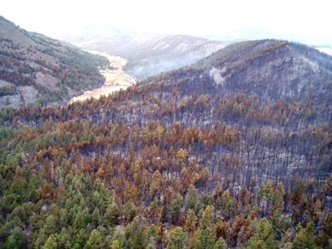
Looking down South Tularosa Canyon toward the village of Mescalero.
Credit: Arnie Friedt, InciWeb
***************
Situation as of 05/04/08
Total Personnel: 315
Size: 3,200 acres
Percent contained: 35 %
Update: The South Tularosa Wildland Fire is now listed on InciWeb. The Southwest Area Type I IMT (Vanbruggen) assumed management of the fire at 8 p.m. on Friday, May 2. The fire started in South Tularosa Canyon on Thursday, May 1 and grew quickly due to extremely dry fuel and Red Flag wind conditions. The fire is burning on Mescalero Tribal lands. Air resources available include three on-call air tankers located in Alamogordo and two air attack planes that will monitor the fire activity and one helicopter for incident support. Significant winds are expected to continue throughout this afternoon and may hamper control efforts. Mescalero Tribal lands are under Class 5 Fire Restrictions reflecting the severely dry conditions in the area. Residents and visitors are strongly urged to observe all of the fire restrictions including instructions to smoke only inside buildings and closed vehicles and to be particularly alert during other activities that may start fires. Residents who were asked to evacuate on the night of May 1 have been allowed to return to their homes and the temporary closure of State Highway 244 has been lifted.
Actions: Firefighters on Saturday worked to contain multiple spot fires around the perimeter of the fire on the south and east flanks. Air tankers assisted with one spot fire near State Highway 244 on the north side of the fire.
Fuels: Southwestern edge of the fire includes ganbel oak component. Canopy cover in the timber fuels (ponderosa pine mixed with Douglas-fir) ranges from 60 to 80% and is able to sustain active crown fire within timber fuel types.
Current Wind Conditions: 10-15 mph SE
Current Temperature: 55-60 degrees
Current Humidity: 12-18 %
***************
Situation as of 05/03/08
Total Personnel: ???
Size: 5,000 acres
Percent contained: ???
High winds have been hampering fire fighting efforts. No info or mention of this fire on InciWeb, although this is a Federal agency fire (BIA). No info available at the Southwest Coordination Center either.
Evacuation have been lifted for residents in South Tularosa Canyon and Mudd Canyon. The BIA reported no homes or buildings were lost as of Friday morning, and the fire had moved to an area where it wasn’t threatening any homes.
Highway 244 has been opened.
The cause of the fire is still under investigation.
***************
Situation as of 05/02/08
Total Personnel: ???
Size: 1000+ acres
Percent contained: ???
Summary: Fire is on the Mescalero Apache Indian Reservation. Firefighters report wind driven flames with crowning in timber. Road 244 east of the fire has been closed. Threats to approximately 40 structures and outbuildings.
