Cougar Mountain Fire
Location: 17 mi S of Dayville, Grant Co. OR
Specific Location: E of the John Day (S. Fork) River, S of Murders Creek, Lat 44° 14´ 11″ Lon 119° 28´ 54″
Date of Origin: 09/15/2010
Cause: Lightning
Situation as of 09/18/2010 5:30 pm
Personnel: 242
Size: 2,064 acres
Percent Contained: 60%
Costs to Date: $860,000
All divisions mopping up hot spots along the line. Aerial resources supporting with bucket drops.
As of September 17 at 1400, the fire was determined to be caused by lightning from a thunder storm that moved through the area on September 14th.
***************
Situation as of 09/17/2010 6:00 pm
Personnel: 240
Size: 2,064 acres
Percent Contained: 60%
Costs to Date: $512,000
All area closures remain in effect. All Malheur NF lands E from the NF Boundary between the intersections of Forest Road 2170 and Forest Road 24 (Deer Creek Road); N of Forest Road 24 between County Road 42 (South Fork Road); W of Forest Road 2480 from its intersection with Forest Road 24; W of Forest Road 2490 from its intersection with Forest Road 2480 and its intersection with Forest Road 2170; S of Forest Road 2170 from its intersection with Forest Road 2490 and the intersection with the W NF Boundary.
No explanation given for cost estimate reduction. Good progress made on the N and E flanks of the fire. Mop up operations have started on the W and S sides, with emphasis on working 50-100′ in from fire perimeter. Fire may receive some wetting rains by Saturday night and early Sunday. Possibility of some isolated thunderstorms. Most of the fire activity is in the areas of timber and in islands of unburned fuels inside the fire perimeter.
***************
Situation as of 09/16/2010 6:00 pm
Personnel: 221
Size: 2,047 acres
Percent Contained: 10%
Costs to Date: $750,000
Conducted burnout operations, building line. Evacuations of dispersed hunting camps is complete.
Moving current ICP from Dayville Guard Station to an area closer to the fire, in order to reduce travel time and increase efficiency. National Caterer has been ordered.
Phoenix Let It Burn Fire
Location: 4 mi NE of Crater Lake, Klamath Co. OR
Specific Location: NE corner of Crater Lake National Park, 1 mi S of Hwy 138 , Lat 43° 4´ 18″ Lon 122° 1´ 14″
Date of Origin: 08/17/2010 (reported for the first time today)
Cause: Lightning
Situation as of 09/08/2010 6:00 pm
Personnel: 19
Size: 600 acres
Percent Contained: 0%
Desired incineration area: 10,000 acres
Costs to Date: $600,000
The South Central Oregon Fire Management Partnership (SCOFMP) Type 3 Team (Hunter) transitioned the fire to local NPS Type 3 Management (Wills). Significant fire growth occurred since prior report due to warmer weather and successful burn out along the Crater Lake National Park and Fremont-Winema National Forests boundary. Wet weather has entered the fire area and current fire growth is minimal.
***************
Situation as of 09/04/2010 2:00 pm
Personnel: 42
Size: 350 acres
Percent Contained: 0%
Desired incineration area: 10,000 acres
Costs to Date: $500,000
South Central Oregon Fire Management Partnership (SCOFMP)Type 3 Team (Hunter) assumed command of the fire at 0800 on September 4, 2010. The decision to transition to the Type 3 team was based on forecasted high winds in alignment with slope and fuels.
***************
Situation as of 09/02/2010 7:35 pm
Personnel: 26
Size: 350 acres
Percent Contained: 0%
Desired incineration area: 10,000 acres
The Phoenix Fire received .25 inches of precipitation on 8/30/2010. Since the end of the precipitation, activity has slowly increased with hotter and drier weather. The fire is beginning to show signs of growth and is actively burning in heavy fuels.
***************
Situation as of 08/27/2010 5:45 pm
Personnel: 134
Size: 300 acres (a guess-timate)
Percent Contained: 0%
Desired incineration area: 2,500 acres
Fire activity and subsequent growth on August 26, 2010 resulted in a 20 acre slopover on the Fremont/Winema National Forests. In response to the slopover, additional resources were ordered for the operational period of August 27, 2010. Many of these resources will be released at the end of shift. [sic]
Note: The NPS (Crater Lake NP) does Let It Burn, but the USFS (Fremont-Winema NF) does not wish for the NPS to incinerate USFS forests. So just to be pills, the NPS allows their fire to burn onto the USFS, causing unwanted emergency expenses to the USFS. This kind of inter-agency bullying and middle finger waving is symptomatic of government gone haywire.
***************
Situation as of 08/26/2010 4:00 pm
Personnel: 52
Size: 200 acres (a guess-timate)
Percent Contained: 0%
Desired incineration area: 2,500 acres
Significant growth occurred on the Phoenix Fire yesterday due to strong, gusty winds from the predicted cold front moving through. No effort being made to line or otherwise control this fire.
Update 08/27 11:00 am: Fire has moved onto Fremont-Winema NF 9 mi E of Diamond Lake Junction. Resources ordered.
Willamette NZ Lightning Fire
Location: Vicinity of Detroit Lake, Linn Co. OR
Specific Location: Willamette NF, Lat 44° 39´ 28″ Lon 122° 13´ 28″
Date of Origin: 08/17/2010
Cause: Lightning
Situation as of 08/25/2010 5:15 pm
Personnel: 191
Size: 134 acres
Percent Contained: 85%
Costs to Date: $1,360,000
Scott Mountain Let It Burn Fire
Location: 14 mi NE of McKenzie Bridge, Willamette NF, Linn Co. OR
Specific Location: near Kuitan Lake, Mt Washington Wilderness, Lat 44°16′9″ Lon 121°54′30″
Date of Origin: 08/19/2010
Cause: Lightning
Situation as of 09/12/2010 8:00 pm
Personnel: 87
Size: 3,464 acres
Percent Contained: 35%
Costs to Date: $4,500,000
Continue mop-up in portion outside the wilderness. Prepare checkline on Trail 3508. Continue preparation of secondary control lines.
***************
Situation as of 09/11/2010 8:00 pm
Personnel: 78
Size: 3,464 acres
Percent Contained: 35%
Costs to Date: $4,400,000
Smoldering and creeping on SE corner of fire. Prepare checkline on Trail 3508.
***************
Situation as of 09/10/2010 7:10 pm
Personnel: 78
Size: 3,464 acres
Percent Contained: 35%
Costs to Date: $4,400,000
Continue mop-up outside the wilderness and work on contingency lines.
***************
Situation as of 09/09/2010 6:30 pm
Personnel: 92
Size: 3,464 acres
Percent Contained: 35%
Costs to Date: $4,348,000
Continue mop-up outside the wilderness and work on contingency lines.
***************
Situation as of 09/08/2010 6:40 pm
Personnel: 92
Size: 3,464 acres
Percent Contained: 35%
Costs to Date: $4,296,000
Area closure remains in effect.
***************
Situation as of 09/07/2010 6:30 pm
Personnel: 92
Size: 3,464 acres
Percent Contained: 35%
Costs to Date: $4,100,000
Continue mopping up but only outside of wilderness where fire continues to burn unchecked.
***************
Situation as of 09/05/2010 6:10 pm
Personnel: 99
Size: 3,454 acres
Percent Contained: 35%
Costs to Date: $4,000,000
Smoldering and creeping duff and dead logs. Continue mopping up but only outside of wilderness.
***************
Situation as of 09/02/2010 6:30 pm
Personnel: 109
Size: 3,454 acres
Percent Contained: 30%
Costs to Date: $3,750,000
Will update 209 when activity changes.
***************
Situation as of 09/01/2010 9:30 am
Personnel: 114
Size: 3,454 acres
Percent Contained: 30%
Costs to Date: $3,750,000
Hwy. 242 reopened last evening. Type 3 team in place. Area closure remains. Mop up areas outside the wilderness.
***************
Situation as of 08/31/2010 1:30 pm
Personnel: 285
Size: 3,454 acres
Percent Contained: 30%
Costs to Date: $3,576,000
Hwy. 242 reopened last evening. Type 3 team arrival and shadowing. Demobilization of resources ongoing.
***************
Situation as of 08/30/2010 4:00 pm
Personnel: 397
Size: 3,454 acres
Percent Contained: 30%
Costs to Date: $3,128,000
Wetting rain and snow received throughout the fire area. Hwy. 242 scheduled to be reopened this evening. Demobilization of resources is ongoing. Transition to Type 3 team scheduled for Wednesday, September 1, 2010.
***************
Situation as of 08/29/2010 3:30 pm
Personnel: 547
Size: 3,454 acres
Percent Contained: 30%
Costs to Date: $2,834,000
Fire remains mostly within wilderness area. Containment line have been prepared outside of the wilderness area. Burnout is pending favorable weather. [sic]
Note: unfortunately for the holocauster forest killer contingent, it’s raining, and they won’t be able to burn, baby, burn and kill, baby, kill anymore.
***************
Situation as of 08/28/2010 4:30 pm
Personnel: 560
Size: 3,305 acres
Percent Contained: 30%
Costs to Date: $2,168,000
Hwy. 242 remains closed due to public and firefighter safety. Completion of indirect lines SW of fire. ~$60 million worth of timber incinerated so far.
***************
Situation as of 08/27/2010 3:30 pm
Personnel: 557
Size: 2,884 acres
Percent Contained: 5%
Costs to Date: numbers reported are incompetent
Planned Actions: Scouting for possible line construction.
***************
Situation as of 08/26/2010 4:00 pm
Personnel: 440
Size: 2,559 acres
Percent Contained: 5%
Costs to Date: numbers reported are incompetent
The new strategy is Let It Burn, in violation of the Willamette NF LMRP and FMP. The criminal incompetent responsible is WNF Forest Supervisor Meg Mitchell.
***************
Situation as of 08/25/2010 4:30 pm
Personnel: 292
Size: 935 acres
Percent Contained: 0%
Costs to Date: $1,100,000
Highway 242 closed to non-fire traffic. Four new spot fires reported today, two of them on the south side of Scott Mountain.
PNW Team 3, Jeff Pendleton, IC, assumed command at 1800 yesterday. A new strategy is being analyzed that focuses on protecting watershed and wilderness values, firefighter safety, sold active timber sales, timber, T & E and recreation resource values.
***************
Situation as of 08/24/2010 6:30 pm
Personnel: 147
Size: 600 acres
Percent Contained: 0%
Costs to Date: $1,100,000
Flew a lot of retardant on the south side, used crews to secure anchor to the east, used heavy helicopters to slow fire spread to the north. Type 1 Team assumed command at 1800. They are planning to manage the fire for mulitple objectives given the variables of the wilderness, the timber sales, the boy scout camp, bug kill, and any benefit fire might have on the landscape. [sic]
***************
Situation as of 08/24/2010 6:00 am
Personnel: 120
Size: 200 acres
Percent Contained: 0%
The Melakwa Boy Scout Camp and Scott Lake Campground were evacuated. Active timber sales within a mile to the west. Will utilize critical resource needs to attempt to keep fire from the timber sales and minimize growth onto the general forest lands.
A Type 1 Incident Management Team has been ordered and will take over the managing the suppression efforts starting today. East winds, hot and dry weather expected with thermal trough passage. Continuous heavy fuels, no natural breaks.
View Lake Let It Burn Complex Fires
Location: 12 mi E of Idanha, Jefferson Co. OR
Specific Location: Olallie Lakes area, Mt. Hood NF. Lat 44° 47´ 41″ Lon 121° 47´ 48″
Date of Origin: 08/17/2010
Cause: Lightning
Situation as of 09/09/2010 4:00 pm
Personnel: 86
Size: 4,775 acres
Percent Contained: 80%
$$ Costs to Date: $9,392,088
The fire will be turned back to the Forest at 0600 tomorrow (9/10/10) under a forest type IV management team. This will be the last reporting for this fire unless significant activities occur.
***************
Situation as of 09/08/2010 5:00 pm
Personnel: 193
Size: 4,775 acres
Percent Contained: 80%
$$ Costs to Date: $9,392,088
Continue to monitor the southern perimeter that is burning in the Mt. Jefferson Wilderness area. Bull of the Woods - Road prep is complete for potential future containment actions. Rehab and monitoring of the fire will continue.
***************
Situation as of 09/07/2010 3:00 pm
Personnel: 307
Size: 4,775 acres
Percent Contained: 80%
$$ Costs to Date: $9,246,000
Additional 20 acres burned yesterday in spotted owl stands. This is an old-growth, Let It Burn fire. The Gooberment is killing owls deliberately
NIMO calls it quits after 4 days of owl burning. Not as much fun as they thought it would be. IMT3 White shadowed Cable’s NIMO team today. IMT3 is scheduled to assume command on Wednesday, September 8th at 0600. Fire burns on.
***************
Situation as of 09/05/2010 3:00 pm
Personnel: 537
Size: 4,757 acres
Percent Contained: 35%
$$ Costs to Date: $8,620,200
Additional 20 acres burned yesterday in spotted owl stands. This is an old-growth, Let It Burn fire. The Gooberment is killing owls deliberately
NIMO in command.
Road closures remain in place around the Bull of the Woods Fire. Finished contingency line in the Breitenbush drainage. Continue to monitor and to prep the road system [??? It's a so-called "wilderness area" ???] with mechanical equipment for potential future containment actions. The Bull of the Woods Fire has active backing and flanking fire through heavy fuel accumulations in old growth mixed conifer and slash in harvest units [??? It's a so-called "wilderness area" ???].
Note: The reason the USFS is sitting on their fat cans watching the Bull of the Woods Fire while sucking up major double-time dollars is because it is allegedly a precious wilderness area where man fears to tred. Now we find out there are roads and harvest units in the Let It Burn perimeter.
Why doesn’t the Gooberment set fire to Washington DC instead of Oregon. We residents like it here and would prefer it if Oregon was not incinerated by dingbat flunkies from the Gooberment. Whereas Washington DC is a hell hole of freakazoid Communists and should be burned to the ground on principle.
***************
Situation as of 09/04/2010 5:00 pm
Personnel: 660
Size: 4,736 acres
Percent Contained: 35%
$$ Costs to Date: $8,334,000
Additional 200 acres burned yesterday in spotted owl stands. This is an old-growth, Let It Burn fire. Fry the owls.
NIMO in command.
***************
Situation as of 09/03/2010 5:00 pm
Personnel: 724
Size: 4,580 acres
Percent Contained: 35%
$$ Costs to Date: $7,663,000
Additional 25 acres burned yesterday in spotted owl stands. This is an old-growth, Let It Burn fire. Fry the owls.
Inbriefed the Portland NIMO IMT. Transition with NIMO tomorrow-9/4. NIMO will assume command at 0600 on 9/5.
***************
Situation as of 09/02/2010 5:00 pm
Personnel: 719
Size: 4,523 acres
Percent Contained: 35%
$$ Costs to Date: $6,961,000
Additional 50 acres burned yesterday.
***************
Situation as of 09/01/2010 4:30 pm
Personnel: 719
Size: 4,478 acres
Percent Contained: 35%
$$ Costs to Date: $6,502,000
The Bull of the Woods Fire continues to back into Elk Lake Creek and the Collowash River where heavy or sheltered fuels exist.
Planned Actions: Rehab on the View Lake and Rock Cone Spot Fire. Continue to mop up on the main Pyramid Butte Fire. Construct contingency line to the west of the Pyramid Butte Fire between the forks of the Breitenbush River. Continue road prep around the Bull of the Wood Fire.
***************
Situation as of 08/31/2010 5:30 pm
Personnel: 861
Size: 4,478 acres
Percent Contained: 35%
$$ Costs to Date: $5,864,000
Another 150 acres burned. No plan, no effort to contain the old-growth fire. Spotted owl habitat up in smoke.
***************
Situation as of 08/30/2010 5:00 pm
Personnel: 850
Size: 4,335 acres
Percent Contained: 30%
$$ Costs to Date: $5,155,000
Decline in acreage due to more accurate infrared (FLIRS) information.
Final line construction and mop-up efforts continue on the Pyramid Fire. Continued prep work on Bull of the Woods Fire contingency line. Mop-up continues on the View Lake and Red Cone fires. IMT completed ramp-down plan for Forest consideration.
***************
Situation as of 08/29/2010 5:30 pm
Personnel: 766
Size: 5,876 acres
Percent Contained: 30%
$$ Costs to Date: $4,689,000
Good progress on northern perimeter of Pyramid Fire. Continued road prep work on Bull of the Woods Fire contingency lines. Mop-up continuing on View Lake and Red Cone Fire. Received further guidance from Forest for contingency planning needs.
Strategies for the fires are as follows: View Lake- Full Control, Warm Springs Spot Fire- Full Control, Pyramid Butte- Confine on northern, western, and eastern perimeters- allow southern perimeter to burn in the Mt. Jefferson Wilderness Area, Bull of the Woods- Monitor and prep road system for potential future control lines.
Note: unfortunately for the forest killers at the MHNF who are all hot to incinerate old-growth, the rain is falling and their best laid plans to burn the putative “wilderness” to ashes are foiled. Ha ha, suckers. Crawl back under your government desks.
***************
Situation as of 08/28/2010 4:30 pm
Personnel: 740
Size: 5,817 acres
Percent Contained: 30%
$$ Costs to Date: $3,962,000
Evaluating road closures near the Bull of the Woods Wilderness Area to begin prepping road with mechanized equipment for potential indirect strategy in the future.
~80 million worth of timber alone incinerated to date. No report on the habitat destruction of Northern Spotted Owl stands. But the IMT and the Forest Supervisor are considering a potential indirect strategy, maybe, some day. Who knows?
Burn, baby, burn.
***************
Situation as of 08/27/2010 5:30 pm
Personnel: 647
Size: 3,758 acres
Percent Contained: 30%
$$ Costs to Date: $3,241,000
Evacuation remains in place for Olallie Lake Resort area.
Presented Forest with proposed Course of Action on all fires and received concurrence. Based on new intelligence, strategies for the fires are as follows: View Lake - Full Control, Warm Springs Spot Fire - Full Control; Pyramid/Mt. Jefferson - Confine on northern, western, and eastern perimeters, allow southern perimeter to burn in the Mt. Jefferson Wilderness Area; Bull of the Woods - Monitor and prep road system for potential future control lines.
More forest roads were closed near the Bull of the Woods Wilderness Area to begin prepping road with mechanized equipment for potential indirect strategy in the future.
***************
Situation as of 08/26/2010 5:00 pm
Personnel: 604
Size: 3,037 acres
Percent Contained: 30%
$$ Costs to Date: $2,731,000
Type 3 IMT withdrawn. PNW Team 2 (Type 1 National IMT, Hoff) assumed command of the fire at 0600 today. Yesterday’s strong winds and unstable conditions resulted in a 5-fold growth in the size of the fire. An 80 acres spot fire developed east of the Pyramid Butte Fire (formerly Fire 264) now on the Warm Springs Reservation. No action on fires located in the Bull of the Woods Wilderness.
A decision was made to line a portion of the Pyramid Butte Fire.
Closures for Breitenbush, Harvey and Trout Lake areas.
***************
Situation as of 08/24/2010 6:00 pm
Personnel: 333
Size: 776 acres
Percent Contained: 60%
$$ Costs to Date: $1,763,712
Fire 264 on the north side of Pyramid Butte made a significant push to the NW this afternoon and is now approximately 458 acres. Fire 264 is unmanned, unfought “wilderness” fire. Area closure for Olallie Lakes Recreation Area, including roads and trails, remains in effect.
***************
Situation as of 08/23/2010 6:00 pm
Personnel: 362
Size: 267 acres
Percent Contained: 60%
$$ Costs to Date: $1,051,697 (no update)
Lightning fires in the Olallie Scenic Area as well as the Bull of the Woods wilderness. Area closure for Olallie Lakes recreation area and portions of the wilderness. Strong east winds expected today. Fires in wilderness area unmanned, unfought, Let It Burn. Big blow up today reasonably likely.
***************
Situation as of 08/22/2010 6:00 pm
Personnel: 351
Size: 201 acres
Percent Contained: 60%
$$ Costs to Date: $1,051,697
Acreage in Block 15 includes 113 acres for the View Lake Fire, 24 acres for fires in the Mt. Jefferson Wilderness Area, and 64 acres fo the remaining fires in the Bull of the Woods Wilderness Area. The percent containment in Block 16 and line to build in Block 18 only pertain to fires being managed under a full suppression/perimeter control strategy.
Fire personnel are also working on a long-term analysis of ten fires burning within the Bull of the Woods Wilderness Area. To date, these lightning-caused fires have been monitored by air. Due to the spread of these fires, an area surrounding the junction of the Elk Lake Trail and Welcome Lake Trail will be closed to public access.
***************
Situation as of 08/21/2010 6:30 am
Personnel: 240
Size: 125 acres
Percent Contained: 0%
$$ Costs to Date: $375,000
Structures Threatened: 2 PRIM , 9 COMM , 3 OUTB
Area closure of Olallie Lakes recreation area. All roads and trails closed. Continue handline and putting in hose lay around fire. Hold fireline west of Warm Springs boundary line.
White Lightning Fire
Location: 15 miles N of Warm Springs, Wasco Co. OR
Specific Location: reported coords still incorrect
Date of Origin: 08/17/2010
Cause: Lightning
Situation as of 09/09/2010 4:00 pm
Personnel: none
Size: 33,275 acres
Percent Contained: 100%
Costs to Date: $8,000,000
No explanation for new area, cost estimates.
***************
Situation as of 08/31/2010 4:00 pm
Personnel: 105
Size: 33,701 acres
Percent Contained: 95%
Costs to Date: $7,014,000
Cool temperatures and high RHs continue to help diminish fire activity.
***************
Situation as of 08/30/2010 4:00 pm
Personnel: 136
Size: 33,701 acres
Percent Contained: 95%
Costs to Date: $6,850,000
No explanation given for acreage change.
***************
Situation as of 08/29/2010 7:30 pm
Personnel: 160
Size: 33,251 acres
Percent Contained: 95%
Costs to Date: $6,400,000
Type III team (Davis) assumed control beginning 8/28/10. Report quality plunged concurrently. None of the numbers reported can be considered accurate.
***************
Situation as of 08/28/2010 4:00 pm
Personnel: 279
Size: 33,701 acres (no update)
Percent Contained: 90%
Costs to Date: no update
There was a reburn in Eagle Canyon today.
Type III team assumed control beginning 8/28/10 @ 0800
***************
Situation as of 08/27/2010 5:00 pm
Personnel: 595
Size: 33,701 acres
Percent Contained: 90%
Costs to Date: $6,300,000
Structures Threatened: 20 PRIM , 5 OUTB
Structures Destroyed: 1 PRIM , 3 OUTB
The Deschutes River has been reopened for recreational users as of 0600 hrs this morning. Crews continue to patrol fire lines, map areas for rehabilitation, and meet turn back standards. Night Shift operations have be suspended. More resources are being demobilized in anticipation of turning the fire back to the BIA district 8/28/10 at 0700 hrs.
***************
Situation as of 08/26/2010 5:00 pm
Personnel: 737
Size: 33,701 acres
Percent Contained: 70%
Costs to Date: $5,750,000
Structures Threatened: 20 PRIM , 5 OUTB
Structures Destroyed: 1 PRIM , 3 OUTB
Crews continue to reinforce containment lines, patrol the perimeter and extinguish hotspots. Two acre slop over in Div E picked up by Heavy helicopter and IHC crew in Eagle Creek.
Moderate fire behavior in the interior limited to hot spots some occasional torching noted. Continued reinforcing of containment lines to meet the 300ft turn back standards, mopping up and attacking hotspots within the fire perimeter. Preparations to turn the fire over to a type III team include mapping suppression rehabilitation areas and continuing demobilization of resources.
***************
more »
Lower Deschutes Complex Fires
Location: 5 mi N of Maupin, Wasco Co. OR
Specific Location: Devils Halfacre, Tygh Valley area. Reported coords incorrect. Approx. Lat 45° 14´ 20″ Lon 121° 05´ 30″
Date of Origin: 08/19/2010
Cause: Lightning
Situation as of 08/22/2010 8:00 pm
Personnel: 319
Size: 9,304 acres
Percent Contained: 90%
$$ Costs to Date: $1,667,465
Expected containment of fire tonight at 2200, all suppression objectives achieved. This will be the last report unless significant activity occurs. No observed fire behavior. Transfer of command scheduled for 08/23 with local Type IV organization.
***************
Situation as of 08/21/2010 8:00 pm
Personnel: 316
Size: 9,200 acres
Percent Contained: 90%
$$ Costs to Date: $1,378,545
The Youther Fire of the White Lightning Complex reached the Deschutes River about 9 miles south of Maupin, OR.
Transfer of Command to the BLM Prineville District is planned for 8/23/2010 at 0600 hrs.
***************
Situation as of 08/20/2010 8:00 pm
Personnel: 318
Size: 5,500 acres
Percent Contained: 60%
$$ Costs to Date: $982,469
Central Oregon Interagency Incident Management Team assumed command of this complex at 0600 hrs today. Good progress was made on all divisions. The evacuation of Oak Springs Fish Hatchery has been reduced to a Level 1 Advisory. All other advisories and closures will be lifted as of 0600 hrs, 08/21/10.
Strong winds (gust to 30 mph) tomorrow afternoon beginning between noon and 1400 hrs will effect all incidents in this complex.
Smoldering, creeping in leaf litter in drainage bottoms. Hold and mop-up Devil’s Halfacre and Fall Canyon. Mop-up and patrol Oak Canyon. Tygh Ridge will be patrolled with aircraft.
***************
Situation as of 08/19/2010 6:00 pm
Personnel: 276
Size: 4,900 acres
Percent Contained: 25%
Structures Threatened: 7 PRIM , 2 COMM , 5 OUTB
Structures Destroyed: NONE
Evacuation of Oak Springs Fish Hatchery, White River Falls State Park, and E side of Deschutes River. Immediate closure of Deschutes River from City Park in Maupin to Sandy Beach (including all camp sites, etc).
Heavy use of airtanker, SEATs, and helicopters provided relief for these fires.
Central OR Type 2 IMT will assume command of the fire on 8/20 @ 0600. ICP is at Dufur School. There are no Red Flag Warnings/Watches in effect at this time. (Zone 631 warning lifted @ 2000 tonite.)
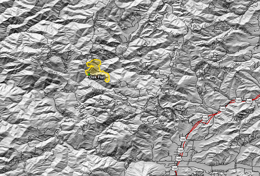
Oak Flat Fire
Location: 8 mi NW of Selma, Josephine Co, OR
Specific Location: Briggs Creek, Horse Mountain, Rogue River-Siskiyou NF, Lat 42° 23´ 58″ Lon 123° 44´ 18″
Date of Origin: 08/13/2010
Cause: Under investigation
Situation as of 09/11/2010 3:15 pm
Personnel: 80
Size: 7,494 acres
Percent Contained: 100%
Costs to Date: $18,810,905 (no update)
Transition from ICT3 Mitchell to ICT4 Hutchinson at 1200 on September 12th, 2010.
***************
Situation as of 09/10/2010 3:30 pm
Personnel: 90
Size: 7,494 acres
Percent Contained: 100%
Costs to Date: $18,810,905 (no update)
Patrol, Monitor, Rehab.
***************
Situation as of 09/09/2010 2:30 pm
Personnel: 87
Size: 7,494 acres
Percent Contained: 100%
Costs to Date: $18,810,905
Mop-up continues.
***************
Situation as of 09/08/2010 6:00 pm
Personnel: 77
Size: 7,494 acres
Percent Contained: 100%
Costs to Date: $18,746,327
T3 team (IC Mitchell) in in place. ICP moves to Merlin Fire Center.
***************
Situation as of 09/07/2010 6:00 pm
Personnel: 359
Size: 7,494 acres
Percent Contained: 100%
Costs to Date: $18,492,024
100% containment declared. Transition from IMT 2 ORCA (Fillis-IC) to Type 3 (Mitchell-IC) occurred at 1800 hrs today. Pockets of activity with limited backing, torching and minimal spread.
***************
Situation as of 09/06/2010 6:00 pm
Personnel: 427
Size: 7,494 acres
Percent Contained: 95%
Costs to Date: ~$18.5 million
Burnout of unburned pockets to achieve a uniform sear across the landscape. Nothing living will remain.
ORCA packed up and gone.
***************
Situation as of 09/05/2010 6:00 pm
Personnel: 576
Size: 7,494 acres
Percent Contained: 73%
Costs to Date: $17,882,897
Fire continues to grow.
ORCA calls it quits after incinerating 7,000 acres for no good reason. Transition to Type 3 organization is scheduled for 9/7/2010 at 1800 hours.
***************
Situation as of 09/04/2010 6:00 pm
Personnel: 607
Size: 7,443 acres
Percent Contained: 73%
Costs to Date: $17,326,706
Fire continues to back into west fork of Briggs Creek. Construction of fire lines on north flank are continuing in Div J. Burnout in divisions D,F and L are mostly complete and mop up has started.
Burnout small islands in Divisions D,F,J and L as perscriptions permit [sic].
Leave nothing green behind. Complete incineration of every acre is the “prescription”.
***************
Situation as of 09/03/2010 6:00 pm
Personnel: 651
Size: 7,400 acres
Percent Contained: 73%
Costs to Date: $16,618,772
Backburn, baby, backburn. Another 650+ acres deliberately incinerated bhy the arsonist feds. Your forests destroyed by fire nazis.
***************
Situation as of 09/02/2010 6:00 pm
Personnel: 671
Size: 6,850 acres
Percent Contained: 73%
Costs to Date: $15,626,848
Burnouts continue. Another 650 acres lost yesterday despite cool and humid weather.
***************
Situation as of 08/31/2010 6:00 pm
Personnel: 737
Size: 6,515 acres
Percent Contained: 70%
Costs to Date: $14,564,245
Currently building line and preparing for burning out. Likelihood of burnout increases due to increase of favorable weather conditions. Burnout in Division D, H and F as the weather permits.
And they are still backburning!!!
The fire is out, there is zero danger from standing next to it, but the Liers That Be are still backburning from miles away in the name of safety!!!!!
What is safe about arson????
What is economic about spending $2,000 per acre to destroy resources worth $20,000 per acre????
***************
Situation as of 08/30/2010 6:00 pm
Personnel: 855
Size: 6,500 acres
Percent Contained: 70%
Costs to Date: $13,720,999
Construction of contingency lines to the north of the fire continues. Although the fire is subdued and smoldering from the rain, ORCA is still building “contingency” lines miles away. The fear of direct attack on a smoldering fire has the firefighters petrified and weeping like school girls. Ambulances are on the ready to carry out the traumatized.
***************
Situation as of 08/29/2010 6:00 pm
Personnel: 837
Size: 6,445 acres
Percent Contained: 70%
Costs to Date: $12,985,320
The rain is coming down, and all additional burnout operations are foiled. Despite efforts by the RR-SNF and ORCA, this fire is unlikely to get any bigger.
***************
Situation as of 08/28/2010 2:00 pm
Personnel: 914
Size: 6,350 acres
Percent Contained: 70%
Costs to Date: $12,085,561
Finally a day where no acreage increase is reported. Evidently the IMT went easy on the burnouts, or the report is incorrect. An additional cost of $1 million was spent yesterday, however. This fire could have been contained at 800 acres. Everything burned in excess of that is deliberate, malicious arson on the part of the USFS.
Reduced fire behavior due to cooler air, higher humidity and cloudy conditions, reduces threat to residence and values at risk. [sic]
Nice to see some minimal lip service toward the victims of this egregious action, the residents.
***************
Situation as of 08/27/2010 6:00 pm
Personnel: 1,014
Size: 6,350 acres
Percent Contained: 65%
Costs to Date: $11,195,100
Another 600 acres deliberately incinerated yesterday, at an additional cost of $1 million. This fire could have been contained at 800 acres. Everything burned in excess of that is deliberate, malicious arson on the part of the USFS.
An additional 12 crews, a few dozers, 2 more type 1 helicopters and several engines were ordered last night for today’s shift. Four air tankers working out of Medford. High winds today may ground aerial attack.
Currently building line and burning out.
***************
Situation as of 08/26/2010 6:00 pm
Personnel: 959
Size: 5,708 acres
Percent Contained: 60%
Costs to Date: $10,010,496
Major blow-out to N, NE. Another 1,000 acres deliberately incinerated yesterday, at an additional cost of $1 million. This fire could have been contained at 800 acres. Everything burned in excess of that is deliberate, malicious arson on the part of the USFS.
The ORCA IMT is without a doubt the most inept and destructive IMT in the nation. The RR-SNF and Region 6 are run by incompetent leftwing political appointees with absolutely no conception of how to manage forests.
Update 8/27: an additional 12 crews, a few dozers, 2 more type 1 helicopters and several engines were ordered last night for today’s shift. Four air tankers working out of Medford. High winds today may ground aerial attack.
***************
Situation as of 08/25/2010 6:00 pm
Personnel: 762
Size: 4,760 acres
Percent Contained: 75%
Costs to Date: $9,301,677
Another 100 acres deliberately incinerated yesterday, at an additional cost of $1 million. This fire could have been contained at 800 acres. Everything burned in excess of that is deliberate, malicious arson on the part of the USFS.
***************
Situation as of 08/24/2010 6:15 pm
Personnel: 950
Size: 4,760 acres
Percent Contained: 75%
Costs to Date: $8,585,135
Another 400 acres deliberately incinerated yesterday, at an additional cost of $1 million. This fire could have been contained at 800 acres. Everything burned in excess of that is deliberate, malicious arson on the part of the USFS.
***************
Situation as of 08/23/2010 6:00 pm
Personnel: 977
Size: 4,363 acres
Percent Contained: 65%
Costs to Date: $7,061,587 (no update, est. $8 million)
Another 1,000 acres deliberately incinerated yesterday, at an estimated (no report) cost of $1 million. This fire could have been contained at 800 acres. Everything burned in excess of that is deliberate, malicious arson on the part of the USFS.
***************
Situation as of 08/22/2010 6:00 pm
Personnel: 1,014
Size: 3,350 acres
Percent Contained: 55%
Costs to Date: $7,061,587
Another 400 acres deliberately incinerated, at a cost of $1 million. This fire could have been contained at 800 acres. Everything burned in excess of that is deliberate, malicious arson on the part of the USFS.
***************
Situation as of 08/21/2010 6:00 pm
Personnel: 1,108
Size: 2,950 acres
Percent Contained: 45%
Costs to Date: $6,071,371
Another 850 acres deliberately incinerated, at a cost of $1.2 million. This fire could have been contained at 800 acres. Everything burned in excess of that is deliberate, malicious arson on the part of the USFS.
***************
Situation as of 08/20/2010 6:00 pm
Personnel: 1,110
Size: 2,100 acres
Percent Contained: 25%
Costs to Date: $4,800,000
Another 400 acres deliberately incinerated. This fire could have been contained at 800 acres. Everything burned in excess of that is deliberate, malicious arson on the part of the USFS.
***************
Situation as of 08/19/2010 6:00 pm
Personnel: 1,110
Size: 1,706 acres
Percent Contained: 18%
Costs to Date: $4,070,494
Burn plan for aerial ignition approved. Road and trail closure in effect.
Regional Forester Review occurred today.
With cloudy and cooler weather approaching for the weekend, fire managers are planning to conduct burnout operations aimed at efficiently connecting the fire into the containment lines within the few days. Both ground and aerial ignition methods will be used, with particular attention paid to minimizing tree mortality and preserving spotted owl habitat.
***************
Situation as of 08/18/2010 7:00 pm
Personnel: 1,050
Size: 1,250 acres
Percent Contained: 10%
Costs to Date: not reported
There are twenty-seven 20-person hand crews and nine engines working in two shifts to build containment lines around the fire. The fire is considered to be 10% contained this morning as work continues to fully contain the Oak Flat Fire.
Fire managers expect conditions to be favorable to conduct burnout operations over the next few days. If conditions are right, additional smoke will be visible from parts of Grants Pass and the Rogue Valley. This operation is designed to safely and methodically remove some of the lighter unburned fuels near the fire lines so that when the fire approaches containment lines, it will not burn as aggressively and the fire line can be better secured and be more effective.
Some of the fire lines used for the 2002 Biscuit Fire are being improved (removing new vegetation growth) in case they are required for contingency fire lines on the Oak Flat Fire. All efforts are being made to reduce the size of the burned area, to minimize additional smoke generation, and to avoid impacts to private lands.
***************
Situation as of 08/17/2010 6:00 pm
Personnel: 708
Size: 925 acres
Percent Contained: 10%
Costs to Date: $1,286,798
Road and trail closures [here]
Longterm analysis team is preparing analysis. Public meeting was held at 7:00 P.M. in the Josephine County Building in Cave Junction on Tuesday, August 17, 2010.
Continue construction of indirect line and prep for burnout operations.
***************
Situation as of 08/16/2010 6:00 pm
Personnel: 483
Size: 800 acres
Percent Contained: 5%
Costs to Date: $500,000
An additional nine, 20-person crews on order. Eight helicopters currently assigned.
Active fire with group torching. Continued prep of roads and construction of hand and dozer line. Continue construction of indirect line and prep for potential burnout operations.
***************
Situation as of 08/15/2010 6:00 pm
Personnel: 337
Size: 600 acres
Percent Contained: 0%
Structures Threatened: 6 PRIM , 15 OUTB
Structures Destroyed: NONE
Transition from Type 3 to Type 2 ORCA at 1800
Active fire with group torching
Big Sheep Fire
Location: 12 Miles SW Enterprise, Wallowa Co., OR
Specific Location: Wallowa-Whitman NF, Lat 45° 23´ 16″, Lon 117° 35´ 1″
Date of Origin: 08/29/2009
Cause: Lightning
Situation as of 10/04/2009 12:50 pm
Personnel: 28
Size: 3,450 acres
Percent contained: 100%
Costs to Date: $1,100,000
This is the last 209 report for this incident.
***************
Situation as of 10/01/2009 6:00 pm
Personnel: 269
Size: 3,450 acres
Percent contained: 20%
Costs to Date: $350,000
The fire is being managed with two objectives. The S portion of the fire in the
Eagle Cap Wilderness is being managed for resource benefit and is in monitor status. The N
portion of the fire is being managed as a full suppression operation due to proximity to private
land and a timber sale.
Deer Ridge Fire
Location: E of Medford, Jackson Co., OR
Specific Location: Rogue River-Siskiyou NF, Lat 42°20′48″, Lon 122°48′42″
Date of Origin: 09/21/2009
Cause: Under investigation
Situation as of 09/22/2009 8:00 pm
Personnel: 611
Size: 633 acres
Percent contained: 45%
Costs to Date: $772,000
350 residences threatened, none destroyed. Evacuees begin to return.
Siskiyou Fire
Location: Ashland Watershed, Jackson Co., OR
Specific Location: Rogue River-Siskiyou NF, Lat 42° 10´ 38″, Lon 122° 40´ 32″
Date of Origin: 09/21/2009
Cause: Under investigation
Situation as of 09/22/2009 8:00 pm
Personnel: 250
Size: 190 acres
Percent contained: 85%
Costs to Date: $831,291
Structures Destroyed: 1 residence , 3 outbuildings
Evacuees are being allowed to return.
Tumblebug Complex Fires
Location: 23 miles SE of Oakridge, Douglas Co., OR
Specific Location: Willamette NF, Tumblebug Creek, Lat 43° 25´ 53″, Lon 122° 14´ 28″
Date of Origin: 09/12/2009
Cause: Lightning
Situation as of 10/04/2009 5:00 pm
Personnel: 211
Size: 14,560 acres
Percent contained: 45%
Costs to Date: $11,914,000
Stumps and heavy fuels will continue to smolder and burn out. Progress is being made with chipping and backhauling of slash along major forest roads. Rehabilitation of fire lines will continue where safe and effective. The BAER team will begin assessing natural resource needs on Monday.
***************
Situation as of 10/01/2009 5:00 pm
Personnel: 232
Size: 14,374 acres
Percent contained: 40%
Costs to Date: $11,215,000
Due to the modified suppression strategy, the fire will not be controlled until a season ending weather event occurs over the area. Recent showers have slowed the fires growth and fire behavior. Stumps and heavy fuels will continue to smolder and burn out. Progress is being made with chipping and backhauling of slash along major forest roads. Rehabilitation of fire lines continues.
***************
Situation as of 09/28/2009 5:00 pm
Personnel: 724
Size: 13,000 acres
Percent contained: 25%
Costs to Date: $10,600,000
Last night the fire grew to the south toward Road 2143308. Additional acreage from last night’s fire growth is not calculated in the current acreage.
Heavy smoke in the lower regions has restricted the use of aircraft.
Spike camps have been demobilized in anticipation of the forecasted cool and showery weather, anticipation of transition with Type 3 organization on Wednesday at 0600.
Observed Fire Behavior: Running fire with group and single tree torching moderate range
spotting up to a mile.
***************
Situation as of 09/27/2009 5:00 pm
Personnel: 1,002
Size: 12,000 acres
Percent contained: 18%
Costs to Date: $9,700,000
***************
Situation as of 09/23/2009 5:00 pm
Personnel: 1,136
Size: 7,000 acres
Percent contained: 5%
Costs to Date: $4,900,000
The fire behavior was again very active this afternoon, under a Haines of 6, with hot and dry weather, and especially active on the S and E perimeter with running fire, group tree torching, with long range spotting up to 1 mile. Probability of ignition is 95%.
Planned Actions: Use night operations for private land protection and burn out. Initial attack all new starts in the IA area and assist the local forest in the IA on new starts outside of the IA area. Continue with patrol and mop up on the successfully suppressed fires in the complex. If the weather allows, re-engage with more direct suppression action on all open perimeter on the Incident, otherwise continue with contigency containment line planning and improvement. Continue to use the helicopters for bucket work in support of the suppression effort and for reconnaisance. The overall highest priority is to keep the fire from spreading N and W.
***************
Situation as of 09/22/2009 5:00 pm
Personnel: 828
Size: 3,500 acres
Percent contained: 5%
Costs to Date: $3,850,000
The size of the road and area closure was increased substantially today to accomodate the increasing size of the Incident. There are multiple recreationists camping within the new closure area that are being displaced. A Branch 3 staffed mainly by the Oregon Department of Forestry has been added to incident to assist in the protection of the private land.
Night operations began yesterday evening in a limited capacity, full night operations are planned for tonight. Overnight IR mapped the incident at 2240 acres, after yesterday’s significant run, much of the north, west, and south perimeter is now open. The incident will likely again be doubled in size with tomorrows IR, based upon this afternoons fire activity.
Extreme fire behavior observed again this afternoon with running fire, group tree torching and short to long range spotting. The incident was much more active earlier today than yesterday.
Boze Fire
Location: 10 miles SW of Toketee Falls, Douglas Co., OR
Specific Location: Black Rock Creek, trib to S. Umpqua, Lat 43° 9´ 39″, Lon 122° 32´ 11″
Date of Origin: 09/13/2009
Cause: Lightning
Situation as of 10/04/2009 5:00 pm
Personnel: 68
Size: 16,725 acres (Boze - 10,640; Rainbow - 6,085)
Percent contained: 20%
Costs to Date: $7,019,985
Fire smoldering. Plan to return to local unit on 10/06.
***************
Situation as of 10/01/2009 5:30 pm
Personnel: 233
Size: 14,500 acres (Boze - 10,500, Rainbow - 4,000)
Percent contained: 20%
Costs to Date: $6,573,426
Continue rehab work snagging and hazard tree falling. Continued demobilization.
***************
Situation as of 09/28/2009 5:30 pm
Personnel: 551
Size: 13,910 acres (Boze 9,482 and Rainbow 3,244)
Percent contained: 20%
Costs to Date: $5,832,008
Continued progress made in chipping brush along Road 28 and other associated roads near the Boze Fire. The acres for the two fires are: Boze 10,092 and Rainbow 3,818.
***************
Situation as of 09/27/2009 5:00 pm
Personnel: 551
Size: 12,726 acres (Boze 9,482 and Rainbow 3,244)
Percent contained: 15%
Costs to Date: $5,406,243
***************
Situation as of 09/23/2009 6:00 pm
Personnel: 596
Size: 9,462 acres
Percent contained: 10%
Costs to Date: $3,088,000
Relocated helicopters from Toketee airstrip to Glide primarily due to smoke and fire spread. Extreme fire behavior on Boze and Rainbow Creek. Some burnout operations are continuing. Expect a reduction in fire behavior and higher relative humidities tomorrow but the fire will still be active. The acres reported are on two fires (Boze, 7,800 acres)(Rainbow Creek, 1,662 acres).
***************
Situation as of 09/22/2009 6:00 pm
Personnel: 542
Size: 7,000 acres
Percent contained: 20%
Costs to Date: $2,800,000
Yesterday very low, single digit relative humidities, along with sustained winds, increased the fire behavior significantly on all flanks of the fire, causing a big increase in acreage. Similiar fire behavior is expected again today.
Status Road closures remain in effect. Forest Service Road(FSR) 28 beginning at French Junction (junction of FSR 28 and 2715) southwest along FSR 28 to spur 430. FSR 2715 from the French Junction (FSR 28) on the east to the junction with FSR 715 on the west. The public is asked to drive slowly and use caution near the South Umpqua river area and to please stay off closed roads.
***************
Situation as of 09/15/2009 5:00 pm
Personnel: 162
Size: 200 acres
Percent contained: 15%
Forest Service Road 2715 was closed between French Junction on the 28 Road to 2814 Road.
Microwave Fire
Location: 3 miles W of Mosier, Wasco Co., OR
Specific Location: Lat 45° 40´ 59″ Lon 121° 28´ 7″
Date of Origin: 08/27/2009
Cause: Under investigation
Situation as of 09/04/2009 8:30 am
Personnel: 258
Size: 1,224 acres
Percent contained: 100%
The fire continues to burn out interior unburned fuels. Motorists traveling on Interstate 84 between Hood River and Mosier may see smoke above the freeway, but are asked to refrain from calling 911. This area is still active and is currently staffed by firefighters.
***************
Situation as of 09/03/2009 11:00 am
Personnel: 536
Size: 1,224 acres
Percent contained: 90%
The fire has been turned back to the local unit for continued mop up.
he Historic Columbia River Highway State Trail between Hood River and Mosier remains closed. Fire Managers and State Park officials are concerned about the hazards to the public caused by rolling rocks and debris. The fire has consumed much of the ground vegetation above the trail which has caused the steep slopes to become unstable. Specialists will evaluate the situation to determine if the hazards can be mitigated and when the trail could be opened.
***************
Situation as of 09/01/2009 10:00 am*
Personnel: 536
Size: 1,224 acres
Percent contained: 90%
*Reports from the NW Interagency Coordination Center have been 24+ hours late all year. Other GACC’s don’t have that problem. Something is amiss at the NWCC. Their contact info is:
NWCC Contact Information
Phone: (503) 808-2720
Admin Fax: (503) 808-2789
Operations Fax: (503) 808-2750
Email: ornwc@dms.nwcg.gov
Please call them and ask them what their main incompetency problem is.
Costs to date: Not reported (see above)
***************
Situation as of 08/31/2009 6:00 am
Personnel: 638
Size: 1,224 acres
Percent contained: 75%
ODF Costs to date - $1,700,000. OSFM Costs to date - $603,000
3 residences, 2 outbuildings destroyed
The fire is also burning in Hood River Co. Burnouts continued to be conducted to strengthen containment lines on the N and NW flanks of the fire. Elsewhere, mop up operations are being emphasized. Planning is underway for the transition to a Type 3 Team.
Canal Creek Fire
Location: 8 miles SW of Detroit, Marion Co. OR
Specific Location: Elk Creek drainage, trib to Canal Creek, trib to Quartzville Creek, Sweet Home RD, Willamette NF, ~Lat 44° 37´ 14″ ~Lon 122° 19´ 04″
Date of Origin: 08/26/2009
Cause: Under Investigation
Situation as of 09/11/2009 11:30 am
Personnel: 117
Size: 283 acres
Percent contained: 96%
Costs to date: $5,385,000
***************
Situation as of 09/10/2009 2:00 pm
Personnel: 117
Size: 283 acres
Percent contained: 96%
Costs to date: $5,291,000
***************
Situation as of 09/08/2009 6:00 pm
Personnel: 189
Size: 283 acres
Percent contained: 95%
Costs to date: $5.1 million (est.)
Quartzville Road (#11) and Kinney Creek Road (#2212) are open.
***************
Situation as of 09/06/2009 7:00 pm
Personnel: 222
Size: 283 acres
Percent contained: 90%
Costs to date: $4,900,000
Rain over the fire area Saturday and Sunday, further reducing active burning.
***************
Situation as of 09/05/2009 8:50 am
Personnel: 356
Size: 283 acres
Percent contained: 80%
Costs to date: not reported
The Type 2 Incident Management Team will transistion to a Type 3 Organization today. Rain is expected over the fire area today and tomorrow, further reducing active burning.
***************
Situation as of 09/04/2009 8:30 am
Personnel: 374
Size: 283 acres
Percent contained: 50%
Costs to date: not reported
Minimal fire behavior was observed yesterday. Crews continue direct containment line construction on the N edge of the fire. Firefighters are monitoring the SE corner of the fire and a spot fire to the E.
***************
Situation as of 09/03/2009 11:00 am
Personnel: 427
Size: 283 acres
Percent contained: 35%
Yesterday fire crews held the fire against high temperatures, lower relative humidity, steep slopes, and falling snags. One of the challenges was burning material rolling downhill. Today winds from the SW are expected and could hinder air support.
Several closures have been issued for the area of roads bound by Forest Road 11, also known as Quartzville Road, to the south, Forest Road 1131 to the west, Forest Road 1133 to the east and Forest Road 2212, also known as Kinney Creek Road, to the north at Detroit Dam. Recreation is not permitted within the closure area. The public is asked to avoid the fire area due to heavy fire traffic and concerns for public safety.
***************
Situation as of 09/01/2009 5:00 pm*
Personnel: 473
Size: 283 acres
Percent contained: 25%
*Reports from the NW Interagency Coordination Center have been 24+ hours late all year. Other GACC’s don’t have that problem. Something is amiss at the NWCC. Their contact info is:
NWCC Contact Information
Phone: (503) 808-2720
Admin Fax: (503) 808-2789
Operations Fax: (503) 808-2750
Email: ornwc@dms.nwcg.gov
Please call them and ask them what their main incompetency problem is.
Costs to date: $3,100,000**
**So far the agencies involved have spent more than $1,000 per acre on this small fire that has been burning for a week. It is still only 25% contained. Private and public forest lands are at risk. The appearance of a) incompetence, b) milking the taxpayer, or c) both, cannot be denied.
***************
