Basin Complex Fire
Location: Ventana, Los Padres NF, Monterey Co., CA
Specific Location: Lat 36° 12′ 37″; Lon 121° 44′ 22″
Date of Origin: 06/21/08
Cause: Lightning
Situation as of 07/24/08 6:00 AM
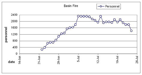
Total Personnel: 1,684
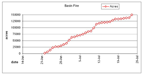
Size: 147,114 acres
Percent Contained: 72%
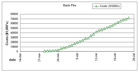
Cost to date: not updated, est. $72 million
Increased fire activity occurred due to higher temperatures and lower relative humidity. Active fire was observed in the interior of the fire with frequent isolated torching and intense uphill runs when in proper alignment. Fire was generally backing in Carmel River and Miller Canyons. Increased fire activity was also observed in the area of Arroyo Seco.
***************
Situation as of 07/23/08 6:00 AM
Total Personnel: 1,793
Size: 139,167 acres
Percent Contained: 72%
Cost to date: $69,416,304
***************
Situation as of 07/22/08 6:00 PM
Total Personnel: 1,793
Size: 138,220 acres
Percent Contained: 72%
Cost to date: $68,094,000
Burning operations continued from Miller Canyon to the Los Padres Dam and firing operations north of the dam have been completed. Crews continued to burn out and improve containment lines in the area of Miller Canyon and initiated burn operations for structure protection in Tanbark. Crews completed the burning operations in the area of Arroyo Seco on the eastern perimeter, but an increase of interior fire activity was reported.
***************
Situation as of 07/20/08 6:00 PM
Total Personnel: 2,115
Size: 134,118 acres
Percent Contained: 70%
Cost to date: $62,764,483
A Voluntary Evacuation remains in effect for all residents off of Carmel Valley Road from Arroyo Seco in the south to Cachagua Road junction in the north. A structure contingency plan is in place for Upper and Lower Cachagua, Zen, Tanbark, Freds, Miller, White Rock, and Santa Lucia.
Crews continued to make good progress with burning operations in the area of Arroyo Seco on the eastern perimeter. Pretreatment for burnout operations in the area of Bluerock Ridge was completed and crews are prepared to initiate firing when appropriate conditions exist. Crews continued to make progress on containment and burn out in the area of Miller Canyon. In the Northern portion of the Indians Fire, scout and determine needs for rehab.
***************
Situation as of 07/19/08 6:00 PM
Total Personnel: 1,951
Size: 133,709 acres
Percent Contained: 70%
Cost to date: $59,002,269
Est date of containment: 07/30/2008
A Voluntary Evacuation remains in effect for all residents off of Carmel Valley Road from Arroyo Seco in the south to Cachagua Road junction in the north. A structure contingency plan is in place at Upper and Lower Cachagua, Zen, Freds, Miller, White Rock, and Santa Lucia. Crews continued to make good progress with burning operations in the area of Arroyo Seco on the eastern perimeter. Two spot fires east of Rocky Creek were contained today. The southern portion of the fire continued to be patrolled by air. Crews also continued to make progress on containment in the area of Carmel River.
CIIMT 3 (Pincha-Tulley) assumed management responsibilities of the East Basin Complex today at 1800 hrs.
The stated objective of burning off the Ventana has been achieved. To date over 215,000 acres (336 square miles) have been incinerated by the Basin/Indians fires at a “suppression” cost of over $100 million. In addition, 27 residences and 34 outbuildings have been destroyed. The USFS is nearly finished with its work on the Los Padres, having burned the southern section in the 240,000 acre Zaca Fire last year.
The residents will suffer the aftereffects of the demolition of their landscapes and watersheds for decades.
***************
Situation as of 07/18/08 6:00 PM
Total Personnel: 2,109
Size: 133,270 acres
Percent Contained: 70%
Cost to date: not reported, est $56 million
***************
Situation as of 07/17/08 6:00 PM
Total Personnel: 1,923
Size: 128,350 acres
Percent Contained: 65%
Cost to date: $53,800,000
***************
Situation as of 07/16/08 6:00 PM
Total Personnel: 1,967
Size: 122,980 acres
Percent Contained: 61%
Cost to date: $51,000,000
The Evacuation Order remains in effect for the Carmel Valley Road to Piney Creek Road and for the community of Lower Cachagua.
Backfire operations continued today with good progress. Crews were able to carry fire towards Carmel Valley Road. The King City ICP was closed and move to the Tassajara ICP.
***************
Situation as of 07/15/08 6:00 PM
Total Personnel: 1,967
Size: 121,980 acres
Percent Contained: 61%
Cost to date: $48,900,000
Evacuation Order remains in effect for the areas including: The intersection of Martin Road south along both sides of Carmel Valley Road to Piney Creek Road. Piney Creek Road will remain open to traffic.
Crews began firing operations N of the MIRA Observatory into the Anastasia Canyon and Bear Trap area. Firing operations are expected to continue for the next 10-14 days.
Fire observed in the Piney and Calaboose Creek area continues to back towards Carmel Valley Road with some isolated short runs.
***************
Situation as of 07/14/08 6:00 PM
Total Personnel: 1,905
Size: 120,386 acres
Percent Contained: 61%
Cost to date: $46,600,000
A Mandatory Evacuation Order remains in effect for the Lower Cachagua area. The Upper Cachagua and Carmel Valley Road areas have moved from an Advisory to a Voluntary Evacuation.
Fire Behavior was moderated throughout todays Operational Period due to higher Relative Humidities and shading from smoke in valleys and drainages. Fire had some creeping with minimal forward progression today.
A Burning Operation planned for tomorrow’s operational period.
***************
Situation as of 07/13/08 6:00 PM
Total Personnel: 2,301
Size: 119,728 acres
Percent Contained: 61%
Cost to date: $44,997,871
The area of Lower Cachagua remains under a Mandatory Evacuation. The Upper Cachagua and Carmel Valley Road areas have moved from an Advisory Evacuation to a Voluntary Evacuation
Increased fire activity in Calaboose Creek, Miller Canyon, and Piney Creek areas. Fire continues to actively back into the Calaboose Creek drainage
***************
Situation as of 07/12/08 6:00 PM
Total Personnel: 1,932
Size: 116,829 acres
Percent Contained: 61%
Cost to date: $42,143,537
Voluntary Evacuations of Upper Cachagua, Paloma Creek, Lower Carmel Valley Road and Arroyo Seco.
Structures destroyed to date: 26 residences , 32 outbuildings
Large increase in acreage from two burning periods. Combined Basin/Indians total to date: 198,207 acres.
Continue firing operation from Chew’s Lookout to the east and south as weather conditions permit.
***************
Situation as of 07/11/08 6:00 PM
Total Personnel: 2,051
Size: 113,827 acres
Percent Contained: 41%
Cost to date: $37,140,714
Structures Destroyed: 26 residences , 32 outbuildings
Eastside fire has passed through Tassajara Zen Center Thursday. Several small buildings were lost: the Bird House, the compost shed, the wood shed and the pool bathroom. The radio-phone and half of the lower garden were also destroyed [here, here]. Fire continues to move north towards Miller Canyon.
***************
Situation as of 07/10/08 6:00 PM
Total Personnel: 2,144
Size: 99,021 acres
Percent Contained: 41%
Cost to date: $33,793,821
The fire was very active today burning toward the east into the Tassajara Rd and Caves area. Pine Valley has been burned over. The eastside fire front is at or near China Camp. Tassajara Hot Springs has been evacuated. According to Firefighter Blog, five residents remain but no firefighters are on the scene [here].
The Basin Fire has merged with the Indians Fire. Both sides of the westside Indians fire line, built at great effort and expense, are now burned.
Fire managers plan to build a “contingency” line from Palo Colorado Road to White Rock, indicating that they expect or consider possible that the fire will spread at least that far north. White Rock is ~5 miles from densely populated Carmel Valley. Currently a fire line is under construction on Skinner Ridge. It is unclear whether that line extends east to Mt. Carmel and the Big Pines Trail. Should the fire overrun that line, White Rock Ridge is the next ridge to the north.
***************
Situation as of 07/09/08 6:00 AM
Total Personnel: 2,275
Size: 86,726 acres
Percent Contained: 27%
Cost to date: $27,835,300
***************
Situation as of 07/08/08 6:00 PM
Total Personnel: 2,299
Size: 85,717 acres
Percent Contained: 23%
Cost to date: $27,664,621
The Basin Fire is now larger than the Indians Fire (81,378 acres). Combined acreage is over 167,000 acres (261 sq miles). Combined fire suppression costs exceed $70 million.
Mandatory evacuation from the intersection of Highway 1 and Palo Colorado Road south to Julia Pfeiffer Burns State Park has been changed to an Advisory. From Julia Pfeiffer Burns State Park south to Lucia, a Mandatory evacuation will remain in place.
***************
Situation as of 07/07/08 6:00 PM
Total Personnel: 2,302
Size: 80,186 acres
Percent Contained: 18%
Cost to date: $24,210,20
Burnout operation in the NW corner along the Old Coast Road is nearly complete.
***************
Situation as of 07/06/08 6:00 PM
Total Personnel: 2,308
Size: 74,985 acres
Percent Contained: 11%
Cost to date: $21,521,400
Structures Destroyed: 23 residences , 23 outbuildings
A successful burnout has secured Pico Blanco Boy Scout Camp. A major burnout was accomplished from Big Sur River to Little Sur River.
The fire has entered into the community of Big Sur on the east side and burned to Highway 1. Fire behavior was high to extreme in the north, northwest and southwest flanks with group tree torching, spotting and short duration crown fire runs. Fire is smoldering around the community of Big Sur.
A mandatory evacuation and road closure is in effect for the entire community of Big Sur and both sides of Hwy 1 from Lucia Inn north to Palo Colorado Road. An evacuation advisory remains in place for residents of the Palo Colorado Canyon from Hwy 1 to the Pico Blanco Boy Scout Camp and from Lucia Inn South to Lime Kiln State Park.
***************
Situation as of 07/05/08 6:00 PM
Total Personnel: 2,318
Size: 71,285 acres
Percent Contained: 5%
Cost to date: $19,611,200
Structures Destroyed: 22 residences, 17 outbuildings
A mandatory evacuation and road closure is in effect for the entire community of Big Sur and both sides of Hwy 1 from Lucia Inn north to Palo Colorado Road. An evacuation advisory remains in place for residents of the Palo Colorado Canyon from Hwy 1 to the Pico Blanco Boy Scout Camp and from Lucia Inn South to Lime Kiln State Park.
Structure preparation on Carmel Valley Road and Cachagua areas and line improvement near Arroyo Seco, Piney Creek and Los Padres Dam.
Fire behavior was high to extreme in the north, northwest and southwest flanks with group tree torching, spotting and short duration crown fire runs.
***************
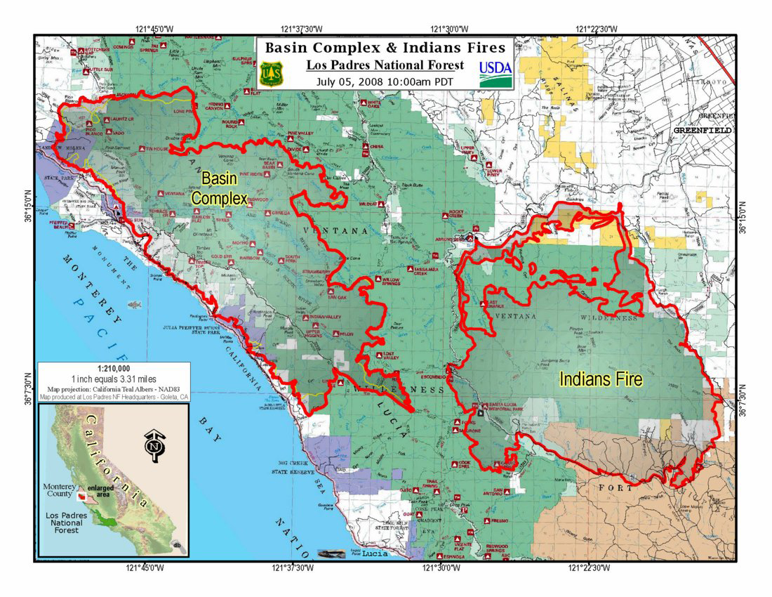
Combined Indians Fire/Basin Fire map as of 07/05 —- click on map for larger image.
Situation as of 07/04/08 6:00 PM
Total Personnel: 1,795
Size: 68,712 acres
Percent Contained: 5%
Cost to date: $16,764,700
The fire has entered into the community of Big Sur on the east side.
***************
Situation as of 07/03/08 6:00 PM
Total Personnel: 1632
Size: 64,305 acres
Percent Contained: 5%
Cost to date: $13,677,800
Structures Destroyed: 20 residences (3 today) , 3 outbuildings
A mandatory evacuation and road closure has been put into effect for the entire community of Big Sur and both sides of Hwy 1 from Lime Kiln State Park north to Palo Colorado Road. A Red Cross evacuation center has been opened at Carmel Valley Middle School located at 4380 Carmel Valley Road in Carmel Valley (831-624-6921). The evacuation in Big Sur has displaced 1500 residents, effected 500 homes and 20 businesses. An evacuation advisory remains in place for residents of the Palo Colorado Canyon from Hwy 1 to the Pico Blanco Boy Scout Camp.
Structure preparation on Carmel Valley Road and Cachagua areas, Big Sur, Palo Colorado Canyon area and south of Mining Ridge.
Complete dozer line construction on Rodeo Flats Trail. Conduct firing operations to check fire spread along Hwy 1 and on Dolan Ridge. Hold fire south of dozer line from Hwy 1 to Coast Ridge Road. Initiate firing operations if conditions are favorable on Mescal Ridge from Bottchers Gap to the Old Coast Road and from Bottchers Gap to Skinners Ridge.
***************
A Red Flag warning has been issued for today into this evening because of low humidity, strong winds and high temperatures. Ridge top winds 15 – 20 mph gusting to 25 mph. Winds on the fire’s west side expecting gusts up to 30 – 35 mph. Extreme fire activity can be expected.
Situation as of 07/03/08 6:00 AM
Total Personnel: 1601
Size: 64,305 acres
Percent Contained: 3%
Cost to date: $11 million
Offshore winds have caused the fire to make a substantial advance along the coast towards Big Sur. Over 1,472 structures are threatened. The community of Big Sur to the W of the fire and S along Hwy 1, Pico Blanco Boy Scout Camp and Palo Colorado residences are at risk.
***************
Situation as of 07/02/08 PM
NO REPORT
Total Personnel: est 1,600
Size: est 63,000 acres
Percent Contained: 3%
Fire broke through containment lines. Big Sur evacuated.
***************
MANDATORY EVACUATION NOTICE, Effective 8:30 AM, Wednesday, July 02, 2008 has been issued for the residents of the east side of Highway 1 between Nepenthe north to Andrew Molera State Park.
Situation as of 07/01/08 6:00 PM
Total Personnel: 1,542
Size: 51,985 acres
Percent Contained: 3%
Costs to Date: $9,529,500
Structures Threatened: 1,277 PRIM , 195 OUTB Structures Destroyed: 17 PRIM , 3 OUTB
An evacuation and road closure has been put in place from Lime Kiln State Park N to Partington Ridge went into effect at 1700 hrs today. An evacuation advisory remains in place for residents of the Palo Colorado Canyon from Hwy 1 to the Pico Blanco Boy Scout Camp. Evacuations remain in place in the Partington Ridge area. Hwy 1 remains closed south of the Ventana Inn in Big Sur to Lime Kiln State Park N of Nacimiento Ferguson Road.
Continued structure preparation on Carmel Valley Rd. and Cachagua. Continued structure protection assessment and preparation in the Palo Colorado Canyon area and south of Mining Ridge.
Continued dozer line construction on Rodeo Flats to North Coast Trail. Continued dozer line on Chews Ridge to Mira Observatory. Complete dozer line construction on Dolan Ridge. Conduct firing operations to check fire spread along Hwy 1 and on Dolan Ridge and Rodeo Flats Trail. Complete dozer line construction from Hopkins Ridge to the Pfeiffer Big Sur State Park. Hold fire south of dozer line from Hwy 1 to Coast Ridge Road. Continue dozer line construction Blue Rock Ridge west of the Los Padres Reservoir. Complete line constructions on Mescal Ridge to the Old Coast Road.
***************
Situation as of 06/30/08 6:00 PM
Total Personnel: 1,277
Size: 39,906 acres
Percent Contained: 3%
Costs to Date: $7,863,400
An evacuation advisory remains in place for residents of the Palo Colorado Canyon from Hwy 1 to the Pico Blanco Boy Scout Camp. Evacuations remain in place in the Partington Ridge area. Hwy 1 remains closed south of the Ventana Inn in Big Sur to Lucia north of Nacimiento Ferguson Road.
The fire continued backing into the south side of the Big Sur River drainage.
***************
A FIRE EVACUATION ADVISORY has been issued for the Palo Colorado Canyon from US Highway 1 to the Pico Blanco Boy Scout Camp, including the following areas:
Garrapatos Road
Redwood Estates
Green Ridge
Rocky Creek Ranch
Long Ridge
Rocky Creek Road
Ray Ridge Road
An advisory is a precautionary notice and you should prepare for a possible evacuation. The Basin Complex Fire burned actively late Saturday towards the north, south, and to the east. The fire advanced quickly due to steep terrain, and dry, heavy fuels. As a result, it is expected to continue to burn actively towards the Palo Colorado community.
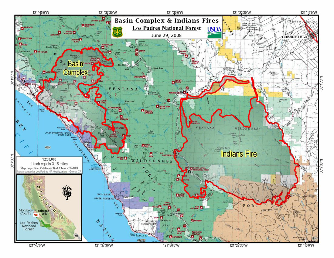
Combined Indians Fire/Basin Fire map as of 06/29 —- click on map for larger image.
Situation as of 06/29/08 6:00 PM
Total Personnel: 1,229
Size: 35,286 acres
Percent Contained: 3%
Costs to Date: $5,859,300
Structures Threatened: 1,277 PRIM , 195 OUTB Structures Destroyed: 16 PRIM , 2 OUTB
An evacuation advisory has been issued by the Sheriff’s Department for residents of the Palo Colorado Canyon from Hwy 1 to the Pico Blanco Boy Scout Camp. Evacuations remain in place in the Partington Ridge area. Hwy 1 remains closed south of the Ventana Inn in Big Sur to Lucia north of Nacimiento Ferguson Road.
***************
Situation as of 06/28/08 6:00 PM
Total Personnel: 1,071
Size: 30,043 acres
Percent Contained: 3%
Costs to Date: $3,100,300
Planned Actions: West Zone: Provide structure protection. Construct dozer/handline from Highway 1 along Dolans Ridge to Rodeo Flat Trail. Construct line on Dolans Ridge from Coastal Ridge Rd to Hwy 1 in preparation for a potential night burnout operation. Construct helispots using rapel crew with helicopters. Construct dozer/handline below Ventana Wilderness boundary to branch break north of Manual Peak and south towards Indians Fire and Coast Ridge Road. East Zone: Construct line along the wilderness boundary towards Tassajara Creek Rd. Assessing the need for line construction in the Rodeo Flats and Carmel Valley Rd area. Prepare structures and provide structure protection on Tassajara Road and near the Zen Center.
***************
Fire Evacuation Advisory has been issued for the Highway 1 corridor between Nacimiento-Fergusson Road and the Nepenthe Turnout. An advisory is a precautionary notice. It means you should prepare for a possible future evacuation. Weather predictions indicate the possibility of southeast winds accompanied by thunder storms with lightning over the weekend. The purpose of this advisory is to give residents ample time to prepare for a possible evacuation.
Situation as of 06/27/08 6:00 PM
Total Personnel: 834
Size: 26,876 acres
Percent Contained: 3%
Costs to Date: $2,448,700
***************
Situation as of 06/26/08 9:00 PM
Total Personnel: 693
Size: 26,763 acres
Percent Contained: 3%
Costs to date: $1,964,700
A Public Meeting was held last night at 7 PM Big Sur Visitor Center/Multi-Agency Facility.
Fire continues to move south into the South Fork of the Big Sur River drainage, and north towards Manuel Peak and is also moving E/NE into Pine Valley and southwest into the South Fork of the Big Sur River. The fire continues to back down towards portions of Highway 1. Structure protection engines remain in place along Partington Ridge, the North Coast Ridge Road and Highway 1. Crews continue to hold the fire east of Highway 1 and south of the community of Big Sur.
HIGHWAY 1 CLOSED SOUTH OF BIG SUR DUE TO MAJOR FIRE; MANY LOCAL BUSINESSES REMAIN OPEN
MONTEREY COUNTY
As of Wednesday, June 25, both directions of Highway 1 south of Big Sur are closed for twelve miles to through traffic due to the Coast Gallery Fire. From the south, the highway is closed at the Esalen from the north at Ventana. There is no estimated time of reopening the highway. The highway has been closed since Saturday afternoon, June 21.
Alternate routes are Hwy. 101 to Hwy. 68 west to Hwy. 1 south in Monterey County or Hwy. 101 to Hwy. 46 west to Hwy. 1 north in San Luis Obispo County. Electronic message signs have been posted to advise motorists.
***************
Situation as of 06/25/08 6:00 PM
Total Personnel: 693
Size: 23,563 acres
Percent Contained: 3%
Costs to date: $1,535,400
Structures damaged/destroyed: 16 Residences, 2 Out-Buildings. Structures threatened: 575
***************
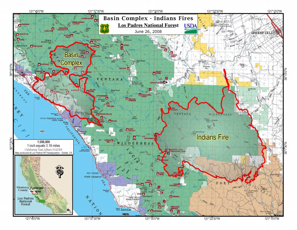
Combined Indians Fire/ Basin Fire map as of 06/26 — click on map for larger image
Situation as of 06/25/08 6:00 AM
Total Personnel: 693
Size: 20,600 acres
Percent Contained: 3%
Costs to date: $1,332,200
The Gallery fire (15,200 acres) continues to move south into the South Fork of the Big Sur River drainage, and north towards Manual Peak. Structure protection engines are in place along Partington Ridge, the North Coast Ridge Road, and Highway 1. Crews are holding the fire east of Highway 1 and south of the community of Big Sur. The Basin fire (5,401 acres) is moving E/NE into Pine Valley and southwest into the South Fork of the Big Sur River. The Gallery and Basin fires are within ½ mile of each other and are expected to join soon.
Evacuations remain in place in the Partington Ridge area. Should further evacuations be required, the Red Cross is prepared to open an evacuation center in Carmel.
Highway 1 remains closed between the Ventana Inn on the north and the Esalen Institute on the south. Julia Pfeiffer Burns State Park is closed. Escorted convoys continue through the closure area for residents only and are subject to change based on fire activity. Residents will be required to show identification. Several businesses along Highway 1 in the fire area are closed. All national forest lands north of Nacimiento-Ferguson Road are closed to public access.
***************
Situation as of 06/25/08 6:00 AM
Total Personnel: 651
Size: 19,100 acres
Percent Contained: 3%
Costs to date: $929,200
Structures damaged/destroyed: 16 residences, 2 out-buildings
The Gallery fire (14,003 acres) burned actively during the night at upper elevations on the eastern flank into the South Fork of the Big Sur River drainage; it continues to move along Anderson Peak towards Marble Peak. Henry Miller library has not been burned by the fire. Structure protection engines are in place along Partington Ridge, the North Coast Ridge Road, and Highway 1. Crews are holding the fire east of Highway 1 and south of the community of Big Sur. However, the north, south, and east flanks of the fire remain open and active. The Basin fire (5,001 acres) continues to burn south and east towards the Tassajara Hot Springs Resort area and into the Big Sur River drainage.
Evacuations remain in place in the Partington Ridge area.
Highway road closures have been relocated to the Esalen Institute on the north and Julia Pfeiffer Burns State Park on the south. Julia Pfeiffer Burns State Park is closed. Escorted convoys have begun through the closure area for residents only and are subject to change based on fire activity. Residents will be required to show identification. Several businesses along Highway 1 in the fire area are closed. All national forest lands north of Nacimiento-Ferguson Road are closed to public access.
***************
Situation as of 06/24/08 6:00 PM
Total Personnel: 380+
Size: 13,500 acres
Percent Contained: 3%
Gallery and Basin Fires have NOT merged. 16 structures reported destroyed.
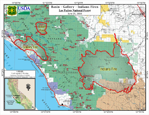
Los Padres fire map 06/25/08
***************
Situation as of 06/23/08 6:00 PM
Total Personnel: 380
Size: 7,025 acres
Percent Contained: 3%
Forest is closed from Nacimiento Road to north end of Forest.
The Logwood fire has been consumed by the Gallery fire. The Complex now has two fires. The Gallery fire is 5920 acres with 10% containment. The Basin fire is 1105 acres with 0% containment. Possible 5 structures/outbuildings damaged in last 24hrs. Confirmation is an ongoing effort.
Active backing fire into the South Fork of the Big Sur River. Running fire when aligned with wind and slope. Fuels highly receptive to spotting to fuel components.
***************
Situation as of 06/22/08 10:30 AM
Total Personnel: 254
Size: 2,040 acres
Percent Contained: 10%
Landslide on Hwy 1 south of the fires has closed the Hwy, Caltrans is monitoring, unsafe to take action to mitigate. Mandatory evacuations from Ventana Inn south to Julia Pfeiffer Day Use Area.
2000 ac for Gallery Fire, Basin Fire is 39 acres with a spot fire 1/2 mile N that is 1 acre. Logwood Fire is a single tree lightning strike.
Planned Actions: Try to hold fire and dozer line between Hwy 1 and N. Coast Ridge Road and south of Big Sur. Personnel have been detailed from the Indians Fire.
The Shining Coast. I grew up there Barry. Hiked the whole Ventana as a Boy Scout: Pine Valley, Chews Ridge, Little Sur, and of course Pico Blanco. It breaks my heart to see what has become of that lovely country. Of course, it was totally roasted in the 187,000 acre Marble Cone Fire in 1977. Hard to believe that was 30 years ago.
It used to be that the Costanoan people kept the Ventana a fine and fair pine/oak savanna by careful burning, in late fall after the acorn harvest. They were wiped out by European diseases, and the remnants enslaved by the Franciscans. The annual burning stopped, but the Spaniards found ample grazing lands and ran half-wild cattle over those hills for a couple of centuries, which had a somewhat similar effect. The grazing maintained the savanna.
Eventually, though, the poison oak and chaparral came up anyway, and the grazing declined. Fuels built up. Then the catastrophic fires.
The fires of today kill everything and promote more chaparral. They are widely-spaced, occurring every 30 years or so, not like the annual fires of the Costanoans. The fires of today do not lead to fine and fair savannas but to fire-type brush.
The whole of Carmel Valley and the other coastal valleys are terrible fire traps today. They have built-up fuels that burn with ferocity, not like the gentle grass fires of yesteryear. And every time a modern fire explodes, it causes huge tragedy to the land and the residents.
The Ventana is a wilderness in name only. It actually has been homeland to human beings of thousands of years. It used to be a tended landscape. Now it is a death trap, and forbidding to humanity.
We have not done right by the Ventana as a society. We have not been good stewards. And we have let that lack of stewardship creep right to our doorsteps.
I fear the big fire that will sweep down Carmel Valley someday. Borne on Santa Ana winds some hot September day, it will kill residents and do a billion dollars in damage. It will be a tragedy far worse than Katrina or the San Diego Fires of 2003 and 2007.
The San Diego fires and the Ventana fires should be a wakeup call to the residents of Monterey County. Something needs to be done, and soon. A monumental disaster lurks.
I wish I knew how to sound that alarm so people would at least consider the possibility. There has to be a community discussion: some deep considerations and dialog about history, botany, stewardship, and public safety.
If anyone in MTY Co. wants to sponsor it, I would dearly love to initiate that discussion in a public way. I fear for my friends, for their property, lives, and landscapes. Let’s explore what could be done to avert terrible tragedy and reconnect with the land in a loving, caring, and responsible fashion, before it’s too late.

My company services most of the Big Sur business between River Inn on the north and Esalen Institute on the south. I find your website to be more comprehensive and informative than any others that I have found. Keep up the good work.