Alder Creek Fire
Location: 12 mile SE of Stevensville, Granite Co. MT
Specific Location: Lolo NF, Lat 46° 26´ 16″ Lon 113° 51´ 3″
Date of Origin: 08/22/2010
Cause: Lightning
Situation as of 08/29/2010 12:30 pm
Personnel: 12
Size: 781 acres
Percent Contained: 100%
Costs to Date: $1,333,052
100% containment. All road closures lifted. Most resources demobilized.
***************
Situation as of 08/27/2010 7:15 pm
Personnel: 136
Size: 750 acres
Percent Contained: 10%
Good progress was made in constructing line and controlling isolated hot spots on the SW flank of the fire. Significant precipitation expected over the fire Saturday evening into Sunday. Continue to construct handline and secure perimeter on the NW and S flanks of the fire.
***************
Situation as of 08/25/2010 8:30 pm
Personnel: 166
Size: 425 acres
Percent Contained: 5%
Heavy use of aircraft to lay down retardant and secure the western edge of the fire in anticipation of the cold front.
Fire had 1 near miss from a falling snag. A facilitate learning analysis will be conducted for future review/lessons learned.
***************
Situation as of 08/24/2010 7:00 pm
Personnel: 142
Size: 375 acres
Percent Contained: 10%
Completed the initial burnout along the NW corner of the fire (100-200ft blackline) along a .3 mile section of line. Closure remain in place for main roads/trails leading into the area. Used aviation resources to reinforce burnout and limit growth of active spots.
***************
Situation as of 08/22/2010 3:20 pm
Personnel: enroute
Size: 250 acres
Percent Contained: 0%
Closures on forest roads and trail put in place. Suppression resources are arriving.
Crown fire with with group tree torching and uphill runs. Fire behavior was fuels,wind and terrian driven. Downhill fire spread was also active due to spotting and rollers.
Bowen Fire
Location: 3 miles NE of Arbon, Power Co., ID.
Specific Location: Pleasant View Hills E of Arbon Valley, Lat 42° 29´ 52″ Lon 112° 31´ 26″
Date of Origin: 08/21/2010
Cause: Under investigation
Situation as of 08/24/2010 6:00 pm
Personnel: 290
Size: 6,683 acres
Percent Contained: 90%
Costs to Date: $720,000
***************
Situation as of 08/23/2010 5:40 pm
Personnel: 272
Size: 6,683 acres
Percent Contained: 70%
Costs to Date: $510,000
Reduction in acreage due to more accurate mapping.
Creeping and smoldering with isolated torching in the timber. Secure line along the east flank utilizing aircraft for support.
***************
Situation as of 08/22/2010 7:00 pm
Personnel: 230
Size: 6,690 acres
Percent Contained: 50%
Received precipitation over the fire area this evening. Secured the E flank using dozers and crews with support from air resources.
***************
Situation as of 08/21/2010 4:30 pm
Personnel: 72
Size: 2,000 acres
Percent Contained: 20%
Structures Threatened: 7 PRIM Structures Destroyed: 1 OUTB
Voluntary evacuations. Fire running and crowning in the Juniper. Try to contain the west flank. Start working on the east flank in the timber.
View Lake Let It Burn Complex Fires
Location: 12 mi E of Idanha, Jefferson Co. OR
Specific Location: Olallie Lakes area, Mt. Hood NF. Lat 44° 47´ 41″ Lon 121° 47´ 48″
Date of Origin: 08/17/2010
Cause: Lightning
Situation as of 09/09/2010 4:00 pm
Personnel: 86
Size: 4,775 acres
Percent Contained: 80%
$$ Costs to Date: $9,392,088
The fire will be turned back to the Forest at 0600 tomorrow (9/10/10) under a forest type IV management team. This will be the last reporting for this fire unless significant activities occur.
***************
Situation as of 09/08/2010 5:00 pm
Personnel: 193
Size: 4,775 acres
Percent Contained: 80%
$$ Costs to Date: $9,392,088
Continue to monitor the southern perimeter that is burning in the Mt. Jefferson Wilderness area. Bull of the Woods - Road prep is complete for potential future containment actions. Rehab and monitoring of the fire will continue.
***************
Situation as of 09/07/2010 3:00 pm
Personnel: 307
Size: 4,775 acres
Percent Contained: 80%
$$ Costs to Date: $9,246,000
Additional 20 acres burned yesterday in spotted owl stands. This is an old-growth, Let It Burn fire. The Gooberment is killing owls deliberately
NIMO calls it quits after 4 days of owl burning. Not as much fun as they thought it would be. IMT3 White shadowed Cable’s NIMO team today. IMT3 is scheduled to assume command on Wednesday, September 8th at 0600. Fire burns on.
***************
Situation as of 09/05/2010 3:00 pm
Personnel: 537
Size: 4,757 acres
Percent Contained: 35%
$$ Costs to Date: $8,620,200
Additional 20 acres burned yesterday in spotted owl stands. This is an old-growth, Let It Burn fire. The Gooberment is killing owls deliberately
NIMO in command.
Road closures remain in place around the Bull of the Woods Fire. Finished contingency line in the Breitenbush drainage. Continue to monitor and to prep the road system [??? It's a so-called "wilderness area" ???] with mechanical equipment for potential future containment actions. The Bull of the Woods Fire has active backing and flanking fire through heavy fuel accumulations in old growth mixed conifer and slash in harvest units [??? It's a so-called "wilderness area" ???].
Note: The reason the USFS is sitting on their fat cans watching the Bull of the Woods Fire while sucking up major double-time dollars is because it is allegedly a precious wilderness area where man fears to tred. Now we find out there are roads and harvest units in the Let It Burn perimeter.
Why doesn’t the Gooberment set fire to Washington DC instead of Oregon. We residents like it here and would prefer it if Oregon was not incinerated by dingbat flunkies from the Gooberment. Whereas Washington DC is a hell hole of freakazoid Communists and should be burned to the ground on principle.
***************
Situation as of 09/04/2010 5:00 pm
Personnel: 660
Size: 4,736 acres
Percent Contained: 35%
$$ Costs to Date: $8,334,000
Additional 200 acres burned yesterday in spotted owl stands. This is an old-growth, Let It Burn fire. Fry the owls.
NIMO in command.
***************
Situation as of 09/03/2010 5:00 pm
Personnel: 724
Size: 4,580 acres
Percent Contained: 35%
$$ Costs to Date: $7,663,000
Additional 25 acres burned yesterday in spotted owl stands. This is an old-growth, Let It Burn fire. Fry the owls.
Inbriefed the Portland NIMO IMT. Transition with NIMO tomorrow-9/4. NIMO will assume command at 0600 on 9/5.
***************
Situation as of 09/02/2010 5:00 pm
Personnel: 719
Size: 4,523 acres
Percent Contained: 35%
$$ Costs to Date: $6,961,000
Additional 50 acres burned yesterday.
***************
Situation as of 09/01/2010 4:30 pm
Personnel: 719
Size: 4,478 acres
Percent Contained: 35%
$$ Costs to Date: $6,502,000
The Bull of the Woods Fire continues to back into Elk Lake Creek and the Collowash River where heavy or sheltered fuels exist.
Planned Actions: Rehab on the View Lake and Rock Cone Spot Fire. Continue to mop up on the main Pyramid Butte Fire. Construct contingency line to the west of the Pyramid Butte Fire between the forks of the Breitenbush River. Continue road prep around the Bull of the Wood Fire.
***************
Situation as of 08/31/2010 5:30 pm
Personnel: 861
Size: 4,478 acres
Percent Contained: 35%
$$ Costs to Date: $5,864,000
Another 150 acres burned. No plan, no effort to contain the old-growth fire. Spotted owl habitat up in smoke.
***************
Situation as of 08/30/2010 5:00 pm
Personnel: 850
Size: 4,335 acres
Percent Contained: 30%
$$ Costs to Date: $5,155,000
Decline in acreage due to more accurate infrared (FLIRS) information.
Final line construction and mop-up efforts continue on the Pyramid Fire. Continued prep work on Bull of the Woods Fire contingency line. Mop-up continues on the View Lake and Red Cone fires. IMT completed ramp-down plan for Forest consideration.
***************
Situation as of 08/29/2010 5:30 pm
Personnel: 766
Size: 5,876 acres
Percent Contained: 30%
$$ Costs to Date: $4,689,000
Good progress on northern perimeter of Pyramid Fire. Continued road prep work on Bull of the Woods Fire contingency lines. Mop-up continuing on View Lake and Red Cone Fire. Received further guidance from Forest for contingency planning needs.
Strategies for the fires are as follows: View Lake- Full Control, Warm Springs Spot Fire- Full Control, Pyramid Butte- Confine on northern, western, and eastern perimeters- allow southern perimeter to burn in the Mt. Jefferson Wilderness Area, Bull of the Woods- Monitor and prep road system for potential future control lines.
Note: unfortunately for the forest killers at the MHNF who are all hot to incinerate old-growth, the rain is falling and their best laid plans to burn the putative “wilderness” to ashes are foiled. Ha ha, suckers. Crawl back under your government desks.
***************
Situation as of 08/28/2010 4:30 pm
Personnel: 740
Size: 5,817 acres
Percent Contained: 30%
$$ Costs to Date: $3,962,000
Evaluating road closures near the Bull of the Woods Wilderness Area to begin prepping road with mechanized equipment for potential indirect strategy in the future.
~80 million worth of timber alone incinerated to date. No report on the habitat destruction of Northern Spotted Owl stands. But the IMT and the Forest Supervisor are considering a potential indirect strategy, maybe, some day. Who knows?
Burn, baby, burn.
***************
Situation as of 08/27/2010 5:30 pm
Personnel: 647
Size: 3,758 acres
Percent Contained: 30%
$$ Costs to Date: $3,241,000
Evacuation remains in place for Olallie Lake Resort area.
Presented Forest with proposed Course of Action on all fires and received concurrence. Based on new intelligence, strategies for the fires are as follows: View Lake - Full Control, Warm Springs Spot Fire - Full Control; Pyramid/Mt. Jefferson - Confine on northern, western, and eastern perimeters, allow southern perimeter to burn in the Mt. Jefferson Wilderness Area; Bull of the Woods - Monitor and prep road system for potential future control lines.
More forest roads were closed near the Bull of the Woods Wilderness Area to begin prepping road with mechanized equipment for potential indirect strategy in the future.
***************
Situation as of 08/26/2010 5:00 pm
Personnel: 604
Size: 3,037 acres
Percent Contained: 30%
$$ Costs to Date: $2,731,000
Type 3 IMT withdrawn. PNW Team 2 (Type 1 National IMT, Hoff) assumed command of the fire at 0600 today. Yesterday’s strong winds and unstable conditions resulted in a 5-fold growth in the size of the fire. An 80 acres spot fire developed east of the Pyramid Butte Fire (formerly Fire 264) now on the Warm Springs Reservation. No action on fires located in the Bull of the Woods Wilderness.
A decision was made to line a portion of the Pyramid Butte Fire.
Closures for Breitenbush, Harvey and Trout Lake areas.
***************
Situation as of 08/24/2010 6:00 pm
Personnel: 333
Size: 776 acres
Percent Contained: 60%
$$ Costs to Date: $1,763,712
Fire 264 on the north side of Pyramid Butte made a significant push to the NW this afternoon and is now approximately 458 acres. Fire 264 is unmanned, unfought “wilderness” fire. Area closure for Olallie Lakes Recreation Area, including roads and trails, remains in effect.
***************
Situation as of 08/23/2010 6:00 pm
Personnel: 362
Size: 267 acres
Percent Contained: 60%
$$ Costs to Date: $1,051,697 (no update)
Lightning fires in the Olallie Scenic Area as well as the Bull of the Woods wilderness. Area closure for Olallie Lakes recreation area and portions of the wilderness. Strong east winds expected today. Fires in wilderness area unmanned, unfought, Let It Burn. Big blow up today reasonably likely.
***************
Situation as of 08/22/2010 6:00 pm
Personnel: 351
Size: 201 acres
Percent Contained: 60%
$$ Costs to Date: $1,051,697
Acreage in Block 15 includes 113 acres for the View Lake Fire, 24 acres for fires in the Mt. Jefferson Wilderness Area, and 64 acres fo the remaining fires in the Bull of the Woods Wilderness Area. The percent containment in Block 16 and line to build in Block 18 only pertain to fires being managed under a full suppression/perimeter control strategy.
Fire personnel are also working on a long-term analysis of ten fires burning within the Bull of the Woods Wilderness Area. To date, these lightning-caused fires have been monitored by air. Due to the spread of these fires, an area surrounding the junction of the Elk Lake Trail and Welcome Lake Trail will be closed to public access.
***************
Situation as of 08/21/2010 6:30 am
Personnel: 240
Size: 125 acres
Percent Contained: 0%
$$ Costs to Date: $375,000
Structures Threatened: 2 PRIM , 9 COMM , 3 OUTB
Area closure of Olallie Lakes recreation area. All roads and trails closed. Continue handline and putting in hose lay around fire. Hold fireline west of Warm Springs boundary line.
Banner Let It Burn Fire
Location: 18 mi NW of Stanley, Custer Co. ID
Specific Location: Banner Creek, Salmon-Challis NF, Lat 44° 22´ 49″ Lon 115° 12´ 35″
Date of Origin: 08/20/2010
Cause: Lightning
Situation as of 08/28/2010 6:00 pm
Personnel: 31
Size: 2,388 acres
Percent Contained: 52%
Costs to Date: $3,580,000
Minimum fire activity with interior smokes.
***************
Situation as of 08/28/2010 6:00 pm
Personnel: 243
Size: 2,388 acres
Percent Contained: 52%
Costs to Date: $3,573,268
Transfer of command to a Type 4 IC at 0600 8/29. Uncontained portion of the fire continues to grow.
***************
Situation as of 08/27/2010 6:00 pm
Personnel: 402
Size: 2,365 acres
Percent Contained: 52%
Costs to Date: $3,303,000
Incident strategies: 57% of fire is containment; 33% of fire is “limited supression” [sic].
Highway 21 road closure lifted today at noon, subject to single lane closure depending on fire activity. 100% of containment objective met.
***************
Situation as of 08/26/2010 6:00 pm
Personnel: 542
Size: 2,365 acres
Percent Contained: 20%
Costs to Date: $2,908,000
Incident strategies: 57% of fire is containment; 33% of fire is “limited supression” [sic].
Red Flag warning today for winds and low RH; lightning on the fire with light precipitation.
***************
Situation as of 08/25/2010 6:00 pm
Personnel: 561
Size: 2,077 acres
Percent Contained: 18%
Costs to Date: numbers reported are false
Incident strategies: 57% of fire is containment; 33% of fire is “limited supression” [sic].
Active single and group tree torching and spotting up to 1/3 mile in sub-alpine fir and lodgepole pine. Cold front blowing through today is expected to be accompanied by strong winds. Fire storm could result, sending burning embers across a wide region.
***************
Situation as of 08/24/2010 6:00 pm
Personnel: 476
Size: 1,730 acres
Percent Contained: 0%
Costs to Date: $1,729,187
Transition to Let It Burn. Desired incinerated zone: 103,494 acres. Blow up expected Thursday.
***************
Situation as of 08/23/2010 6:00 pm
Personnel: 372
Size: 1,594 acres
Percent Contained: 0%
Reduction in acreage due to more accurate mapping; today’s fire growth approximately 80-90 acres. Transfer of command to Wilde Type 2 Team occurred at 0600 hours on 8/23/2010. Highway 21 closure modified to allow single lane, escorted traffic through fire area.
***************
Situation as of 08/22/2010 5:00 pm
Personnel: 344
Size: 2,010 acres
Percent Contained: 0%
Hwy 21 closed. Transition to Wilde Type II Team @ 0600 Aug. 23. Active torching and short range spotting in subalpine fir and lodgepole forest areas.
***************
Situation as of 08/21/2010 8:30 pm
Personnel: 333
Size: 1,000 acres
Percent Contained: 0%
Closure of Highway 21 and limited access to Boundary Creek Road. Prepping Highway 21 for reinforcement of line to keep fire NE of highway. Preparation for Area closure. Type 2 IMT to take over fire.
Continued fire spread mainly to N and E with spotting and active growth on spots.
***************
Situation as of 08/20/2010 5:00 pm
Personnel: 279
Size: 200 acres
Percent Contained: 0%
Evacuations in process for Marsh Creek and Lola Creek Campgrounds; Bradley BSA camp evacuated; Roads into campgrounds closed.
Spotting,torching,crowning. High winds forecast for the weekend.
White Lightning Fire
Location: 15 miles N of Warm Springs, Wasco Co. OR
Specific Location: reported coords still incorrect
Date of Origin: 08/17/2010
Cause: Lightning
Situation as of 09/09/2010 4:00 pm
Personnel: none
Size: 33,275 acres
Percent Contained: 100%
Costs to Date: $8,000,000
No explanation for new area, cost estimates.
***************
Situation as of 08/31/2010 4:00 pm
Personnel: 105
Size: 33,701 acres
Percent Contained: 95%
Costs to Date: $7,014,000
Cool temperatures and high RHs continue to help diminish fire activity.
***************
Situation as of 08/30/2010 4:00 pm
Personnel: 136
Size: 33,701 acres
Percent Contained: 95%
Costs to Date: $6,850,000
No explanation given for acreage change.
***************
Situation as of 08/29/2010 7:30 pm
Personnel: 160
Size: 33,251 acres
Percent Contained: 95%
Costs to Date: $6,400,000
Type III team (Davis) assumed control beginning 8/28/10. Report quality plunged concurrently. None of the numbers reported can be considered accurate.
***************
Situation as of 08/28/2010 4:00 pm
Personnel: 279
Size: 33,701 acres (no update)
Percent Contained: 90%
Costs to Date: no update
There was a reburn in Eagle Canyon today.
Type III team assumed control beginning 8/28/10 @ 0800
***************
Situation as of 08/27/2010 5:00 pm
Personnel: 595
Size: 33,701 acres
Percent Contained: 90%
Costs to Date: $6,300,000
Structures Threatened: 20 PRIM , 5 OUTB
Structures Destroyed: 1 PRIM , 3 OUTB
The Deschutes River has been reopened for recreational users as of 0600 hrs this morning. Crews continue to patrol fire lines, map areas for rehabilitation, and meet turn back standards. Night Shift operations have be suspended. More resources are being demobilized in anticipation of turning the fire back to the BIA district 8/28/10 at 0700 hrs.
***************
Situation as of 08/26/2010 5:00 pm
Personnel: 737
Size: 33,701 acres
Percent Contained: 70%
Costs to Date: $5,750,000
Structures Threatened: 20 PRIM , 5 OUTB
Structures Destroyed: 1 PRIM , 3 OUTB
Crews continue to reinforce containment lines, patrol the perimeter and extinguish hotspots. Two acre slop over in Div E picked up by Heavy helicopter and IHC crew in Eagle Creek.
Moderate fire behavior in the interior limited to hot spots some occasional torching noted. Continued reinforcing of containment lines to meet the 300ft turn back standards, mopping up and attacking hotspots within the fire perimeter. Preparations to turn the fire over to a type III team include mapping suppression rehabilitation areas and continuing demobilization of resources.
***************
more »
Eight Mile Lake Let It Burn Fire
Location: 13 mi SW of Leavenworth, Chelan Co. WA
Specific Location: Alpine Lakes Wilderness area, Okanogan-Wenatchee NF. 47.519 latitude, -120.856 longitude
Date of Origin: 08/18/2010
Cause: Lightning
Situation as of 08/22/2010 3:00 pm
Personnel: 1
Size: 119 acres
Percent Contained: 0%
***************
Situation as of 08/19/2010 6:00 pm
Personnel: 0
Size: 60 acres
Percent Contained: 0%
Eight Mile Lake Fire is burning about midway up a very steep slope directly above Eight Mile Lake. This wilderness fire is largely naturally contained on three sides by very steep, rocky cliffs; Eight Mile Lake lines the bottom of the slope. Old burn areas flank the area to the east and west of the drainage.
The following Trail closures are in effect: Eight Mile Lake Trail #1552, Eight Mile-Trout Lake Trail #1554, closed from Eight Mile Lake to Windy Pass. Hiker reservations for 8 Mile Lake canceled indefinitely. Eight Mile road and campground are open, and access to the Enchantments remains open. The fire does not impact services or accommodations elsewhere in the Icicle Valley or Leavenworth.
Arthur 2 Let It Burn Fire
Location: Yellowstone National Park, Park Co. WY
Specific Location: 1.5 mi SW of the East Entrance to Yellowstone National Park.
Date of Origin: 08/18/2010
Cause: Lightning
Situation as of 08/23/2010 5:00 pm
Personnel: 30
Size: 200 acres
Percent Contained: 0%
Costs to Date: $162,375
Acreage decrease due to more accurate mapping. Cost to date and projected final cost changes updated to reflect more accurate accounting. This will be the last 209 unless activity increases.
Note: Why stop reporting? Is your arm broken? Is it just too difficult to write a 5-line fill-in-the-blanks report every day? 30 people are assigned to the fire. They aren’t doing anything but sitting on their fat cans smoking dope. But it’s beyond their ability to fill in a simple form once a day, a 5-minute job.
NPS employees are the laziest, most worthless culls in America today.
***************
Situation as of 08/22/2010 4:00 pm
Personnel: 57
Size: 218 acres
Percent Contained: 0%
Fire is primarily in the 2001 Arthur Burn where it is consuming downed material. The fire has also established on the north slope south of middle creek and is very visible from Highway 20.
***************
Situation as of 08/21/2010 7:00 pm
Personnel: 40
Size: 218 acres
Percent Contained: 0%
Structures Threatened: 8 PRIM , 10 OUTB
The Northern Rockies Wildland Fire Management Team (Cook) will assume command of the fire at 0800 Sunday. Gives the big boys from NIFC some double overtime and practice at Let It Burn.
***************
Situation as of 08/20/2010 9:00 am
Personnel: 18
Size: 75 acres
Percent Contained: 0%
Yellowstone fire management is working closely with the neighboring Shoshone National Forest. The park has requested a wildfire management team to do a long-term analysis plan for the Arthur 2 Fire (formerly called the East Fire). Fire resources are setting up precautionary structure protection around the East Entrance developed area.
Re-burn within a stand replacement (total mortality) fire from 2001.
This fire is being managed for multiple objectives, including firefighter and public safety, ecological benefits of cleaning up the dead and down from a previous fire, and as a lightning-ignited fire, the Arthur 2 Fire is in line with the park’s resource management plan that calls for allowing natural processes to occur when possible in the park.
Lower Deschutes Complex Fires
Location: 5 mi N of Maupin, Wasco Co. OR
Specific Location: Devils Halfacre, Tygh Valley area. Reported coords incorrect. Approx. Lat 45° 14´ 20″ Lon 121° 05´ 30″
Date of Origin: 08/19/2010
Cause: Lightning
Situation as of 08/22/2010 8:00 pm
Personnel: 319
Size: 9,304 acres
Percent Contained: 90%
$$ Costs to Date: $1,667,465
Expected containment of fire tonight at 2200, all suppression objectives achieved. This will be the last report unless significant activity occurs. No observed fire behavior. Transfer of command scheduled for 08/23 with local Type IV organization.
***************
Situation as of 08/21/2010 8:00 pm
Personnel: 316
Size: 9,200 acres
Percent Contained: 90%
$$ Costs to Date: $1,378,545
The Youther Fire of the White Lightning Complex reached the Deschutes River about 9 miles south of Maupin, OR.
Transfer of Command to the BLM Prineville District is planned for 8/23/2010 at 0600 hrs.
***************
Situation as of 08/20/2010 8:00 pm
Personnel: 318
Size: 5,500 acres
Percent Contained: 60%
$$ Costs to Date: $982,469
Central Oregon Interagency Incident Management Team assumed command of this complex at 0600 hrs today. Good progress was made on all divisions. The evacuation of Oak Springs Fish Hatchery has been reduced to a Level 1 Advisory. All other advisories and closures will be lifted as of 0600 hrs, 08/21/10.
Strong winds (gust to 30 mph) tomorrow afternoon beginning between noon and 1400 hrs will effect all incidents in this complex.
Smoldering, creeping in leaf litter in drainage bottoms. Hold and mop-up Devil’s Halfacre and Fall Canyon. Mop-up and patrol Oak Canyon. Tygh Ridge will be patrolled with aircraft.
***************
Situation as of 08/19/2010 6:00 pm
Personnel: 276
Size: 4,900 acres
Percent Contained: 25%
Structures Threatened: 7 PRIM , 2 COMM , 5 OUTB
Structures Destroyed: NONE
Evacuation of Oak Springs Fish Hatchery, White River Falls State Park, and E side of Deschutes River. Immediate closure of Deschutes River from City Park in Maupin to Sandy Beach (including all camp sites, etc).
Heavy use of airtanker, SEATs, and helicopters provided relief for these fires.
Central OR Type 2 IMT will assume command of the fire on 8/20 @ 0600. ICP is at Dufur School. There are no Red Flag Warnings/Watches in effect at this time. (Zone 631 warning lifted @ 2000 tonite.)
Vernon Let It Burn Fire
Location: Yosemite National Park, Tuolumne Co. CA
Specific Location: 1 mi S of Lake Vernon, 3 mi N of Hetch Hetchy Reservoir. Coords not reported. Approx Lat 37° 59´ 30″ Lon 119° 44´ 00″
Date of Origin: 08/08/2010 (not officially reported until today)
Cause: Lightning (allegedly)
Situation as of 09/15/2010 5:00 pm
Personnel: 3
Size: 692 acres
Percent Contained: 0%
Desired incineration zone: 10,000 acres.
***************
Situation as of 08/26/2010 5:00 pm
Personnel: 5
Size: 360 acres
Percent Contained: 0%
Desired incineration zone: 10,000 acres.
Shamed into issuing a report, today’s NPS 209 indicates that this fire has tripled in size since Monday. The Tuolumne County Air Pollution Control District and Hetch Hetchy San Francisco Water and Power are stooges in all this. Their names are used as “cooperators” but it is doubtful they have a clue about what is going on.
***************
Situation as of 08/23/2010 4:00 pm
Personnel: not reported, evidently zero
Size: 160 acres
Percent Contained: 0%
Desired incineration zone: 5,000 acres.
NPS has decided to stop reporting on this fire. Not that their reports to-date have been worth a plug nickle. What a worthless excuse for a government agency the NPS is.
***************
Situation as of 08/18/2010 6:00 pm
Personnel: not reported
Size: 60 acres
Percent Contained: 0%
Fire is being managed for multiple objectives; primarily forest restoration!
Note: this is new. The NPS now defines wildfire as “restoration”. That kind of bureaucratic doublespeak is an abomination. Old-growth forest destruction by catastrophic wildfire is not “restoration”. Cut their tongues out.
Coooperators [sic] include the Tuolumne County Air Pollution Control District and Hetch Hetchy San Francisco Water and Power.
Note: the NPS is attempting to spread the responsibility for this fire to other bureaucracies.
North Fork Fire
Location: 16 mi W of Lander, Fremont Co. WY
Specific Location: Smith Lake, Cathedral Peak area, Wind River Range, Shoshone NF, Lat 42° 48´ 42″ Lon 109° 7´ 37″
Date of Origin: 08/18/2010
Cause: Under investigation
Situation as of 08/24/2010 5:00 pm
Personnel: 151
Size: 330 acres
Percent Contained: 98%
IR Flight showed no heat in or near the fire line. Demob of Type 3 team and resources. Type 4 organization taking over fire at 0600 tomorrow, 8/25. This will be the last report unless there is significant activity
***************
Situation as of 08/23/2010 5:00 pm
Personnel: 196
Size: 330 acres
Percent Contained: 95%
Excellent progress on containment objectives and turn back standards. Beginning to release resources. Trail closures. Fairfield Hill to Shoshone Lake (FS road 750), Shoshone Lake cutoff from Middle Fork (Trail 711 and North Fork Trail from Dickinson Park (Trail 710).
Firelines continue to hold through operational period. Low winds helped with the start of backhaul of crews and supplies. Smoldering in meadows and bogs. Burning of interior, heavy fuels.
***************
Situation as of 08/22/2010 4:00 pm
Personnel: 201
Size: 330 acres
Percent Contained: 85%
Continued progress with line construction. Released one type one aircraft to another incident. High winds and frontal conditions intensified. Firelines continue to hold through operational period. High winds have kept aircraft grounded in pm hrs.
***************
Situation as of 08/21/2010 4:30 pm
Personnel: 211
Size: 330 acres
Percent Contained: 65%
Resources continue to make progress on incident. Limited isolated torching in the interior perimeter. Creeping behavior on perimeter.
***************
Situation as of 08/20/2010 5:00 pm
Personnel: 211
Size: 330 acres
Percent Contained: 30%
Sunday is a key day in the weather forecast which may move the fire again. Type one resources and aviation assets are key to make progress on the fire over the weekend.
Crews will continue to build line with direct control objectives using air support to cool hot sections of fireline.
***************
Situation as of 08/19/2010 6:00 pm
Personnel: 226
Size: 330 acres
Percent Contained: 15%
Trail closures: Fairfield trail to Dickinson Park
Resources are arriving and being assigned to line operations. Crews will be line building with direct control objectives using air support to cool hot sections of line. Manage spots.
***************
Situation as of 08/18/2010 6:30 pm
Personnel: 46
Size: 150 acres
Percent Contained: 0%
Running crowning with long range spotting. Planned Actions: Evaluate and develop plan of action. Major recreation area.
Willow Creek Fire
Location: ~3 mi E of Mona, Uinta NF, Juab Co. UT
Specific Location: Mt. Nebo Wilderness area, Lat 39° 48´ 9″ Lon 111° 47´ 24″
Date of Origin: 08/16/2010
Cause: Lightning
Situation as of 08/18/2010 6:30 pm
Personnel: 105
Size: 148 acres
Percent Contained: 30%
Costs to Date: $115,000
Significant thunderstorms with wetting rain have moved over the fire area. Demob commencing tonight, transfer to type 4 organization to occur within the next two days.
***************
Situation as of 08/17/2010 4:00 pm
Personnel: 0
Size: 110 acres
Percent Contained: 0%
Thunder Let It Burn Fire
Location: 17 mi NW of Lake Wenatchee, Okanogan-Wenatchee NF, Chelan Co WA
Specific Location: Thunder Creek, S of Glacier Peak, Glacier Peak Wilderness, ~6 mi E of the PCT, Lat 48° 2´ 54″ Lon 121° 0´ 2″
Date of Origin: 08/16/2010
Cause: Lightning
Situation as of 08/17/2010 4:30 pm
Personnel: 4
Size: 125 acres
Percent Contained: 0%
About as remote as you can get in the Lower 48. Trail advisories posted on Trail # 1507 and 1502. Glaciers to the N, White River to the S.
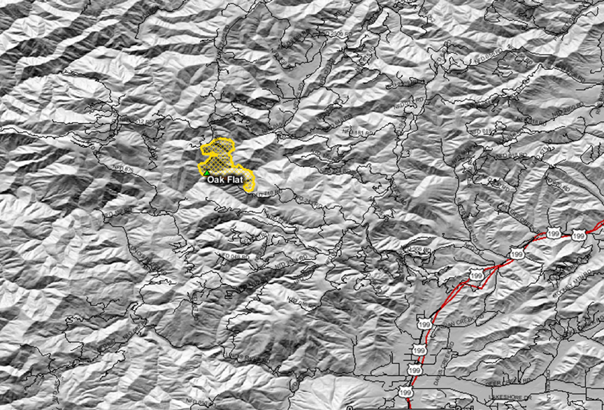
Oak Flat Fire
Location: 8 mi NW of Selma, Josephine Co, OR
Specific Location: Briggs Creek, Horse Mountain, Rogue River-Siskiyou NF, Lat 42° 23´ 58″ Lon 123° 44´ 18″
Date of Origin: 08/13/2010
Cause: Under investigation
Situation as of 09/11/2010 3:15 pm
Personnel: 80
Size: 7,494 acres
Percent Contained: 100%
Costs to Date: $18,810,905 (no update)
Transition from ICT3 Mitchell to ICT4 Hutchinson at 1200 on September 12th, 2010.
***************
Situation as of 09/10/2010 3:30 pm
Personnel: 90
Size: 7,494 acres
Percent Contained: 100%
Costs to Date: $18,810,905 (no update)
Patrol, Monitor, Rehab.
***************
Situation as of 09/09/2010 2:30 pm
Personnel: 87
Size: 7,494 acres
Percent Contained: 100%
Costs to Date: $18,810,905
Mop-up continues.
***************
Situation as of 09/08/2010 6:00 pm
Personnel: 77
Size: 7,494 acres
Percent Contained: 100%
Costs to Date: $18,746,327
T3 team (IC Mitchell) in in place. ICP moves to Merlin Fire Center.
***************
Situation as of 09/07/2010 6:00 pm
Personnel: 359
Size: 7,494 acres
Percent Contained: 100%
Costs to Date: $18,492,024
100% containment declared. Transition from IMT 2 ORCA (Fillis-IC) to Type 3 (Mitchell-IC) occurred at 1800 hrs today. Pockets of activity with limited backing, torching and minimal spread.
***************
Situation as of 09/06/2010 6:00 pm
Personnel: 427
Size: 7,494 acres
Percent Contained: 95%
Costs to Date: ~$18.5 million
Burnout of unburned pockets to achieve a uniform sear across the landscape. Nothing living will remain.
ORCA packed up and gone.
***************
Situation as of 09/05/2010 6:00 pm
Personnel: 576
Size: 7,494 acres
Percent Contained: 73%
Costs to Date: $17,882,897
Fire continues to grow.
ORCA calls it quits after incinerating 7,000 acres for no good reason. Transition to Type 3 organization is scheduled for 9/7/2010 at 1800 hours.
***************
Situation as of 09/04/2010 6:00 pm
Personnel: 607
Size: 7,443 acres
Percent Contained: 73%
Costs to Date: $17,326,706
Fire continues to back into west fork of Briggs Creek. Construction of fire lines on north flank are continuing in Div J. Burnout in divisions D,F and L are mostly complete and mop up has started.
Burnout small islands in Divisions D,F,J and L as perscriptions permit [sic].
Leave nothing green behind. Complete incineration of every acre is the “prescription”.
***************
Situation as of 09/03/2010 6:00 pm
Personnel: 651
Size: 7,400 acres
Percent Contained: 73%
Costs to Date: $16,618,772
Backburn, baby, backburn. Another 650+ acres deliberately incinerated bhy the arsonist feds. Your forests destroyed by fire nazis.
***************
Situation as of 09/02/2010 6:00 pm
Personnel: 671
Size: 6,850 acres
Percent Contained: 73%
Costs to Date: $15,626,848
Burnouts continue. Another 650 acres lost yesterday despite cool and humid weather.
***************
Situation as of 08/31/2010 6:00 pm
Personnel: 737
Size: 6,515 acres
Percent Contained: 70%
Costs to Date: $14,564,245
Currently building line and preparing for burning out. Likelihood of burnout increases due to increase of favorable weather conditions. Burnout in Division D, H and F as the weather permits.
And they are still backburning!!!
The fire is out, there is zero danger from standing next to it, but the Liers That Be are still backburning from miles away in the name of safety!!!!!
What is safe about arson????
What is economic about spending $2,000 per acre to destroy resources worth $20,000 per acre????
***************
Situation as of 08/30/2010 6:00 pm
Personnel: 855
Size: 6,500 acres
Percent Contained: 70%
Costs to Date: $13,720,999
Construction of contingency lines to the north of the fire continues. Although the fire is subdued and smoldering from the rain, ORCA is still building “contingency” lines miles away. The fear of direct attack on a smoldering fire has the firefighters petrified and weeping like school girls. Ambulances are on the ready to carry out the traumatized.
***************
Situation as of 08/29/2010 6:00 pm
Personnel: 837
Size: 6,445 acres
Percent Contained: 70%
Costs to Date: $12,985,320
The rain is coming down, and all additional burnout operations are foiled. Despite efforts by the RR-SNF and ORCA, this fire is unlikely to get any bigger.
***************
Situation as of 08/28/2010 2:00 pm
Personnel: 914
Size: 6,350 acres
Percent Contained: 70%
Costs to Date: $12,085,561
Finally a day where no acreage increase is reported. Evidently the IMT went easy on the burnouts, or the report is incorrect. An additional cost of $1 million was spent yesterday, however. This fire could have been contained at 800 acres. Everything burned in excess of that is deliberate, malicious arson on the part of the USFS.
Reduced fire behavior due to cooler air, higher humidity and cloudy conditions, reduces threat to residence and values at risk. [sic]
Nice to see some minimal lip service toward the victims of this egregious action, the residents.
***************
Situation as of 08/27/2010 6:00 pm
Personnel: 1,014
Size: 6,350 acres
Percent Contained: 65%
Costs to Date: $11,195,100
Another 600 acres deliberately incinerated yesterday, at an additional cost of $1 million. This fire could have been contained at 800 acres. Everything burned in excess of that is deliberate, malicious arson on the part of the USFS.
An additional 12 crews, a few dozers, 2 more type 1 helicopters and several engines were ordered last night for today’s shift. Four air tankers working out of Medford. High winds today may ground aerial attack.
Currently building line and burning out.
***************
Situation as of 08/26/2010 6:00 pm
Personnel: 959
Size: 5,708 acres
Percent Contained: 60%
Costs to Date: $10,010,496
Major blow-out to N, NE. Another 1,000 acres deliberately incinerated yesterday, at an additional cost of $1 million. This fire could have been contained at 800 acres. Everything burned in excess of that is deliberate, malicious arson on the part of the USFS.
The ORCA IMT is without a doubt the most inept and destructive IMT in the nation. The RR-SNF and Region 6 are run by incompetent leftwing political appointees with absolutely no conception of how to manage forests.
Update 8/27: an additional 12 crews, a few dozers, 2 more type 1 helicopters and several engines were ordered last night for today’s shift. Four air tankers working out of Medford. High winds today may ground aerial attack.
***************
Situation as of 08/25/2010 6:00 pm
Personnel: 762
Size: 4,760 acres
Percent Contained: 75%
Costs to Date: $9,301,677
Another 100 acres deliberately incinerated yesterday, at an additional cost of $1 million. This fire could have been contained at 800 acres. Everything burned in excess of that is deliberate, malicious arson on the part of the USFS.
***************
Situation as of 08/24/2010 6:15 pm
Personnel: 950
Size: 4,760 acres
Percent Contained: 75%
Costs to Date: $8,585,135
Another 400 acres deliberately incinerated yesterday, at an additional cost of $1 million. This fire could have been contained at 800 acres. Everything burned in excess of that is deliberate, malicious arson on the part of the USFS.
***************
Situation as of 08/23/2010 6:00 pm
Personnel: 977
Size: 4,363 acres
Percent Contained: 65%
Costs to Date: $7,061,587 (no update, est. $8 million)
Another 1,000 acres deliberately incinerated yesterday, at an estimated (no report) cost of $1 million. This fire could have been contained at 800 acres. Everything burned in excess of that is deliberate, malicious arson on the part of the USFS.
***************
Situation as of 08/22/2010 6:00 pm
Personnel: 1,014
Size: 3,350 acres
Percent Contained: 55%
Costs to Date: $7,061,587
Another 400 acres deliberately incinerated, at a cost of $1 million. This fire could have been contained at 800 acres. Everything burned in excess of that is deliberate, malicious arson on the part of the USFS.
***************
Situation as of 08/21/2010 6:00 pm
Personnel: 1,108
Size: 2,950 acres
Percent Contained: 45%
Costs to Date: $6,071,371
Another 850 acres deliberately incinerated, at a cost of $1.2 million. This fire could have been contained at 800 acres. Everything burned in excess of that is deliberate, malicious arson on the part of the USFS.
***************
Situation as of 08/20/2010 6:00 pm
Personnel: 1,110
Size: 2,100 acres
Percent Contained: 25%
Costs to Date: $4,800,000
Another 400 acres deliberately incinerated. This fire could have been contained at 800 acres. Everything burned in excess of that is deliberate, malicious arson on the part of the USFS.
***************
Situation as of 08/19/2010 6:00 pm
Personnel: 1,110
Size: 1,706 acres
Percent Contained: 18%
Costs to Date: $4,070,494
Burn plan for aerial ignition approved. Road and trail closure in effect.
Regional Forester Review occurred today.
With cloudy and cooler weather approaching for the weekend, fire managers are planning to conduct burnout operations aimed at efficiently connecting the fire into the containment lines within the few days. Both ground and aerial ignition methods will be used, with particular attention paid to minimizing tree mortality and preserving spotted owl habitat.
***************
Situation as of 08/18/2010 7:00 pm
Personnel: 1,050
Size: 1,250 acres
Percent Contained: 10%
Costs to Date: not reported
There are twenty-seven 20-person hand crews and nine engines working in two shifts to build containment lines around the fire. The fire is considered to be 10% contained this morning as work continues to fully contain the Oak Flat Fire.
Fire managers expect conditions to be favorable to conduct burnout operations over the next few days. If conditions are right, additional smoke will be visible from parts of Grants Pass and the Rogue Valley. This operation is designed to safely and methodically remove some of the lighter unburned fuels near the fire lines so that when the fire approaches containment lines, it will not burn as aggressively and the fire line can be better secured and be more effective.
Some of the fire lines used for the 2002 Biscuit Fire are being improved (removing new vegetation growth) in case they are required for contingency fire lines on the Oak Flat Fire. All efforts are being made to reduce the size of the burned area, to minimize additional smoke generation, and to avoid impacts to private lands.
***************
Situation as of 08/17/2010 6:00 pm
Personnel: 708
Size: 925 acres
Percent Contained: 10%
Costs to Date: $1,286,798
Road and trail closures [here]
Longterm analysis team is preparing analysis. Public meeting was held at 7:00 P.M. in the Josephine County Building in Cave Junction on Tuesday, August 17, 2010.
Continue construction of indirect line and prep for burnout operations.
***************
Situation as of 08/16/2010 6:00 pm
Personnel: 483
Size: 800 acres
Percent Contained: 5%
Costs to Date: $500,000
An additional nine, 20-person crews on order. Eight helicopters currently assigned.
Active fire with group torching. Continued prep of roads and construction of hand and dozer line. Continue construction of indirect line and prep for potential burnout operations.
***************
Situation as of 08/15/2010 6:00 pm
Personnel: 337
Size: 600 acres
Percent Contained: 0%
Structures Threatened: 6 PRIM , 15 OUTB
Structures Destroyed: NONE
Transition from Type 3 to Type 2 ORCA at 1800
Active fire with group torching
Sheep Let It Burn Fire
Location: 13 mi E of Pinehurst, Kings Canyon National Park, Tulare Co. CA
Specific Location: S of Lookout Peak, 1.5 mi SW of Cedar Grove, Lat 36° 45´ 31″ Lon 118° 41´ 25″
Date of Origin: 07/17/2010
Cause: Lightning
Situation as of 10/04/2010 4:00 pm
Personnel: 31
Size: 9,007 acres (3,119 acs KCNP - 5,888 acs SNF)
Percent Contained: 70%
Costs to Date: $1,567,000
Fire has transitioned to the Hume Lake Ranger District of the Sequoia National Forest. Bye bye Kings Canyon NP. THANKS FOR THE DISASTER.
***************
Situation as of 10/03/2010 4:00 pm
Personnel: 46
Size: 9,007 acres (3,119 acs KCNP - 5,888 acs SNF)
Percent Contained: 70%
Costs to Date: $1,567,000
Suppression rehabilitation activities and demobilization of resources.
***************
Situation as of 09/28/2010 3:40 pm
Personnel: 132
Size: 8,802 acres (3,109 acs KCNP - 5,693 acs SNF)
Percent Contained: 55%
Costs to Date: $1,500,000 (this number is highly inaccurate)
Fire continues to grow.
***************
Situation as of 09/25/2010 4:00 pm
Personnel: 200
Size: 8,450 acres (3,095 acs KCNP - 5,355 acs SNF)
Percent Contained: 30%
Costs to Date: $1,335,000 (this number is highly inaccurate)
Finished firing operations on 9/24/10. Western spread of fire has been stopped on DIV W.
***************
Situation as of 09/22/2010 4:00 pm
Personnel: 160
Size: 7,887 acres (3,089 acs KCNP - 4,798 acs SNF)
Percent Contained: 30%
Costs to Date: $1,250,000
Crews are holding line from Deer Meadow to the N along Deer Ridge.
***************
Situation as of 09/20/2010 4:00 pm
Personnel: 178
Size: 7,562 acres (3,078 acs KCNP - 4,484 acs SNF)
Percent Contained: 10%
Costs to Date: $1,199,000
The fire crossed Lightning Creek on 9/13/10. Fire is showing approximately 150 to 400 acres of growth per day. Burnout on the S. side of the fire in front of the main fire. Also, holding operations along FS Road 14S11. Crews have begun burnout operations and holding line from Deer Meadow to the North along Deer Ridge.
***************
Situation as of 09/18/2010 3:45 pm
Personnel: 137
Size: 6,990 acres (3,057 acs KCNP - 3,933 acs SNF)
Percent Contained: 10%
Costs to Date: $1,184,000
The fire isn’t burning enough resources to satisfy the Federal Gummit, so personnel have been added to boost the destruction quotient.
***************
Situation as of 09/17/2010 6:00 pm
Personnel: 95
Size: 6,990 acres (3,057 acs KCNP - 3,933 acs SNF)
Percent Contained: 10%
Costs to Date: No reporting. Gummit stonewall blackout. Need to know basis only. Top Secret.
Another 800 acres incinerated yesterday. La la la …
Inversion patterns holding the smoke in the Central Valley and causing severe health problems. La la la…
USFS expanded their area closure on the Hume Lake Ranger District. Deer Meadow Giant Sequoia Grove now threatened. Potential fire spread in Highway 180 corridor and N of the Kings River. La la la….
Planned burnout operations to remove fuels from the oncoming fire and provide better control of the western line are anticipated to begin tomorrow. Additional hotshot crews have been ordered to complete this assignment.
It’s a party fire! Join the festivities! Smoke ‘em if you got ‘em.
***************
Situation as of 09/16/2010 4:00 pm
Personnel: 115
Size: 6,191 acres
Percent Contained: 10%
Costs to Date: $1,100,000 (no update)
Fire growth has been showing 150-400 acres daily. SQF has 3143 acres incinerated and NPS has 3048 acres incinerated. Deliberately. No NEPA, no regrets. Burn baby burn.
***************
Situation as of 09/14/2010 4:00 pm
Personnel: 95
Size: 5,765 acres
Percent Contained: 10%
Costs to Date: $1,100,000
After two months of burning and a million dollars spent, this fire continues to grow. The arsonist functionaries in charge promise to continue to “monitor” its “progress” however.
Uphill runs on W side of Lightning Creek as another 500 acres incinerated.
***************
Situation as of 09/12/2010 4:00 pm
Personnel: 118
Size: 5,261 acres
Percent Contained: 10%
Costs to Date: $995,000
After two months of burning and a million dollars spent, this fire continues to grow. The arsonist functionaries in charge promise to continue to “monitor” its “progress” however.
***************
Situation as of 09/11/2010 4:00 pm
Personnel: 140
Size: 5,113 acres
Percent Contained: 0%
Costs to Date: $915,000
Meeting scheduled for 9/14/10 at Hume Lake Ranger District Office between USFS-SQF and NPS-KNP.
Continues to back down to the west toward Lightning Creek.
***************
Situation as of 09/08/2010 4:00 pm
Personnel: 115
Size: 4,857 acres
Percent Contained: 0%
Costs to Date: $875,000
Rattlesnake Creek trail closure within Kings Canyon National Park. Also, an Area Closure in the Hume Lake Ranger District. A Temporary Flight Restriction in the area of the Sheep Fire is also in effect.
Incident Planning Meeting scheduled for 9/9/10 at Hume Lake Ranger District Office between USFS-SQF and NPS-KNP. Cost increase due to more detailed accounting analysis.
Fire continues to back down to the west toward Lightning Creek. Scouting west of west perimeter for a proposed handline.
***************
Situation as of 09/05/2010 4:00 pm
Personnel: 53
Size: 3,915 acres
Percent Contained: 0%
Rattlesnake Creek trail closure within Kings Canyon National Park. Also, an Area Closure in the Hume Lake Ranger District. A Temporary Flight Restriction in the area of the Sheep Fire is also in effect.
Incident Planning Meeting scheduled for 9/9/10 at Hume Lake Ranger District Office between USFS-SQF and NPS-KNP.
Fire continues to actively back down to the west toward Lightning Creek.
***************
Situation as of 08/25/2010 4:20 pm
Personnel: 61
Size: 2,425 acres
Percent Contained: 0%
Party fire. Burn down the park. Cool, man.
***************
Situation as of 08/23/2010 4:00 pm
Personnel: 53
Size: 2,025 acres
Percent Contained: 0%
Fire showed moderate to high activity and began to run up the slopes toward Lookout Peak. Fire will be monitored, not suppressed, by 53 highly paid personnel, but no monitoring reports will be produced. This is a party fire. Smoke ‘em if you got ‘em.
***************
Situation as of 08/21/2010 4:15 pm
Personnel: 45
Size: 1,805 acres
Percent Contained: 0%
Lower fire activity today resulting in less smoke from yesterday. [sic]
Fire unstaffed.
***************
Situation as of 08/19/2010 4:20 pm
Personnel: 103
Size: 1,805 acres
Percent Contained: 0%
Fire has spread onto the Sequoia National Forest on the western flank.
***************
Situation as of 08/18/2010 4:00 pm
Personnel: 78
Size: 1,246 acres (no update)
Percent Contained: 0%
Fire growth yesterday not reported. Firing operations allegedly planned adjacent to threatened Park facilities. Fire personnel doubled. Trails closed. Air pollution. Water pollution. Wildlife habitat destruction. Heritage giant sequoia groves threatened. Visitors impacted on the busiest weekend of the year.
Park Superintendent Karen Taylor-Goodrich is the government functionary responsible for this fiasco.
***************
Situation as of 08/17/2010 4:00 pm
Personnel: 39
Size: 1,246 acres
Percent Contained: 0%
Fire doubled in size. Firing operations planned for 8/17/10 and 8/18/10 to secure fire in the Cedar Grove area near Hwy 180. Park facilities threatened. Trails closed. Air pollution.
***************
Situation as of 08/13/2010 4:00 pm
Personnel: 0
Size: 648 acres
Percent Contained: 0%
Fire has crossed the W Fork of Sheep Creek and is moving toward the US Forest Service/Park Service Boundary [Sequoia NF]. Completed hose lay around Cedar Grove Helibase as a contingency measure. Continue to monitor by air.
Hopper Let It Burn Fire
Location: 14 mi W of Duckabush, Olympic National Park, Jefferson Co. WA
Specific Location: S of Mt. Hopper, N Fork Skokomish R., Lat 47° 37´ 10″ Lon 123° 17´ 54″
Date of Origin: 08/03/2010
Cause: Lightning
Situation as of 08/26/2010 4:30 pm
Personnel: 0
Size: unknown
Percent Contained: 0%
Monitoring crew withdrawn. Trails remain closed.
***************
Situation as of 08/19/2010 5:15 pm
Personnel: 12
Size: 385 acres
Percent Contained: 15%
Percent contained is identified to show that 15% of the fire has burned up to rock outcrops or snow fields, not because of any suppression actions taken.
Ten person fuels crew is installing monitoring plots on fire. Fire activity was minimal today. Cloud cover over the fire in morning finally broke after noon, when a slight increase in activity was observed. Activity limited to occasional torching, but primarily creeping fire, with burning heavy downed logs. Cooler weather, with cloud cover expected over the fire next few days. If activity remains minor, will drop staffing to two to four monitors early next week. After this 209, will only report every Thursday unless significant activity occurs or if a request from NWCC is made for more frequent 209’s.
***************
Situation as of 08/17/2010 5:00 pm
Personnel: 15
Size: 381 acres
Percent Contained: 10%
Fire is approximately 10 percent contained due to burning up into rock bluff on Mt. Hopper. Hiking in 10 person fuels crew with ICT4 install rapid assessment plots and to complete further monitoring requirements. Initial monitor team will begin hike out tomorrow. Saw additional growth of approximately 50 acres as fire continues to spread by gravity downslope with small torching and run activity in steeper portions.
***************
Situation as of 08/16/2010 5:30 pm
Personnel: 10
Size: 330 acres
Percent Contained: 0%
10 person NPS fuels module to install rapid assessment plots on the fire. They will also be utilized if needed to install check lines on the northern flank, due to a chance the fire could spread into Crazy Creek Drainage. If decision is made to try to hold fire at trail, they will be utilized for control tactics along trail. Crew will hike in on Tuesday and be on fire on Wednesday.
***************
Situation as of 08/15/2010 7:00 pm
Personnel: 7
Size: 325 acres
Percent Contained: 0%
Closure on Skokomish River trail at Nine Stream Camp and at the Home Sweet Home/Duckabush trail junction.
Fire trebled in size. 10 person NPS crew will hike into fire on Tuesday to be in place for northern containment line if needed.
No discussion of Andrew Palmer Rules (emergency evacuation of injured firefighters).
***************
Situation as of 08/13/2010 6:00 pm
Personnel: 5
Size: 120 acres
Percent Contained: 0%
