Gunbarrel WFU Fire
Location: 40 miles W of Cody, Shoshone NF, Park Co., WY
Specific Location: near Yellowstone NP, 2.5 mi N of Hwy. 14, Lat 44° 29´ 41″ Lon 109° 49´ 25″
Date of Origin: 07/26/2008
Cause: lightning
Situation as of 09/08/08 4:55 PM
Total Personnel: 3
Size: 67,141 acres
Percent Contained: 78%
Est containment date: 10/15/08
Costs to Date: not updated, est. $11 million
2 reported smokes today in a large green area. Area is surrounded by black. Resources are enroute to try and locate the 2 new smokes.
***************
Situation as of 09/03/08 4:30 PM
Total Personnel: 44
Size: 67,141 acres
Percent Contained: 78%
Est containment date: 10/15/08
Costs to Date: not updated, est. $10.8 million
Kole Berriochoa Type 3 Local Team now in charge of this fire.
***************
Situation as of 09/02/08 3:00 PM
Total Personnel: 139
Size: 67,141 acres
Percent Contained: 78%
Est containment date: 10/15/08
Costs to Date: $10,606,111
Transfer command of the Gunbarrel Fire to Type 3 organization (Berriochoa) at 1800 hrs. today. The IC, PIO, LOFR and Agency Admin. met with the Park County Commissioners this morning. Began removing ICP from Buffalo Bill State Park.
Last report unless significant fire activity occurs. [No, this will not be the last report. This fire is going to haunt careers from now until Doomsday - Ed]
***************
Situation as of 09/01/08 4:00 PM
Total Personnel: 164
Size: 67,141 acres
Percent Contained: 78%
Est containment date: 10/15/08
Costs to Date: $10,500,000
Acre increase due to inclusion of large unburned affected area within fire perimeter that had previously been excluded from the totals.
Fire received 1/2 inch of precip last night with snow above 7,500 feet. On and off rain during the day today. Broyles IMT1 transitioning with Type 3 organization for transfer of command on Tuesday, 09/02/08 at 1800 hrs. Continue to demob and dismantle and remove Gunbarrel ICP.
***************
Situation as of 08/31/08 4:00 PM
Total Personnel: 338
Size: 61,923 acres
Percent Contained: 70%
Est containment date: 10/15/08
Costs to Date: $10,300,000
Single and group tree torching with minimal fire movement. Continue equipment recovery and rehab fire lines. Monitor fire activity. Continue to demob toward smaller Type 3 organization.
***************
Situation as of 08/30/08 5:00 PM
Total Personnel: 476
Size: 61,433 acres
Percent Contained: 55%
Est containment date: 10/15/08
Costs to Date: $9,860,899
Burnout operations conducted last evening in Division X were successful in securing structures in the Division.
Red Flag Warning (high winds) for Saturday and Sunday.
***************
Situation as of 08/29/08 4:00 PM
Total Personnel: 540
Size: 59,147 acres (no update, IR not flown)
Percent Contained: 50%
Est containment date: 10/15/08
Costs to Date: $9,100,000
Heavy helicopters were used in support of structure protection operations in Divisions C, B, X and W and hold the fire S of the drainage divide in Robber’s Roost Creek. Type 1 crews were used to cold trail and hot spot N of the highway in Division W.
Red Flag Warning (high winds) for Saturday and Sunday.
***************
Situation as of 08/28/08 5:30 PM
Total Personnel: 569
Size: 59,147 acres
Percent Contained: 16%
Costs to Date: $8,085,000
Heavy helicopters were used in support of structure protection operations in Divisions B,C,X and W. Retardant plant established to support suppression efforts.
No explanation for the decline in acreage.
Another Palouser (late summer Northern Rockies windstorm) is expected Saturday or Sunday.
***************
Situation as of 08/27/08 5:30 PM
Total Personnel: 364
Size: 57,384 acres
Percent Contained: 13%
Costs to Date: $7,800,000
A red flag warning was issued from 1200 hrs to 2100 hrs today.
Fire, pushed by 40 mph sustained winds out of the west and northwest, caused extreme fire behavior, with spotting up to 0.5 miles on the east end of the fire.
Broyles IMT1 assumed incident command at 0600 hrs. today. Heavy helicopters were used in support of structure protection operations in Divisions X and W until they were grounded by high winds around noon.
***************
Situation as of 08/26/08 5:30 PM
Total Personnel: 349
Size: 55,471 acres
Percent Contained: 13%
Costs to Date: $7,603,000
Two lodges remains on stage one evacuation notice; fire has backed down toward the management action point, burn out operations are underway. Structure protection evaluation and actions in Trout Creek and Rattlesnake drainages.
Broyles IMT1 is shadowing today Hahnenberg FUMT and will assume command at 0600 on Wednesday.
Red Flag Warning in effect until 9 PM this evening and from 12 PM to 9 PM MDT Wednesday.
***************
Situation as of 08/25/08 6:00 PM
Total Personnel: 250
Size: 53,960 acres
Percent Contained: 13%
Costs to Date: $6,988,000
Fire is highly active on both ends of the incident, potential fire growth and increased demands for aircraft has prompted the need for a type one IMT. Team was ordered last night and Paul Broyles’ Type 1 IMT will be in-briefed in the morning in Cody, WY. Three Fire Use Modules are counted as overhead
Red Flag Warning will increase fire behavior this evening, over night and up to 1800 tomorrow. Fire is running up unburned stringers on the west side with spotting and back activity. Fire activity is increasing in the Trout Creek area. Fire is slope and wind driven with spotting, running and backing.
Flag warning will continue through the day early evening. Expecting extreme fire behavior for the next 24 hours.
Structures Threatened: 420 residences, 11 commercial buildings, 149 outbuildings
***************
Situation as of 08/24/08 6:00 PM
Total Personnel: 231
Size: 52,974 acres
Percent Contained: 13%
MMA: whoops, this no longer applies
Costs to Date: $6,570,000
Fire was converted to a suppression incident at midnight!!!!
That’s it for whoofoo. Six and a half million bucks and 50,000 acres whoofooed, and now they finally figure out that maybe it wasn’t such a swell idea after all!!
Fire activity has become plume dominated with an increase in fire behavior on the west in Libby Creek; Big Creek, Jim Creek, North Fork of Big Creek; and on the east in Trout Creek. Fire is slope and wind driven with spotting, running and backing.
Red Flag Warning for Monday, gusty winds and low humidity.
Airtankers and helitankers are attempting to slow the growth in the eastern portions of the fire. Medium helicopters are attempting to slow the growth in Libby Creek. High winds may ground the air attack Monday, however.
Structures Threatened: 420 residences, 11 commercial buildings, 149 outbuildings
***************
Situation as of 08/23/08 5:30 PM
Total Personnel: 203
Size: 52,388 acres
Percent Contained: 0%
MMA: 416,112 acres
Costs to Date: $6,111,000
Fire has breached a couple of management action points and has moved out of the MMA on the eastern portion of the fire and into the Trout Creek drainage. Fire continues to move south down toward improvements in the Big Creek and Jim Creek subdivision. County and federal resources continue structural protection planning on private improvements east of Big Creek and updating the Community Protection Plan. With the fire breaching the MMA, the Forest is preparing a WFSA and will continue to manage the fire with the same strategy and tactics.
[That's a cut-and paste. That's what they said. The fire has jumped the boundary is bearing down on homes, and the strategy is the same: watch it burn, slack-jawed and impotent. - Ed]
***************
Situation as of 08/22/08 5:30 PM
Total Personnel: 167
Size: 50,615 acres
Percent Contained: 0%
MMA: 416,112 acres
Costs to Date: $5,914,000
Fire has breached a couple of management action points and has moved out of the MMA. Fire spotted over Jim Mountain and is now established in the Trout Creek drainage on the E end of the fire. Fire has moved S down toward improvements in the Big Creek and Jim Creek subdivision and a couple of home were triaged overnight. County resources continue structural protection planning on private improvements E of Big Creek. Line construction and burnouts are ongoing in the Big Creek area to protect private structures.
Planning has begun on a Long Term Implementation Plan for the area out of the MMA.
Continue to monitor fire for resource benefit.
[These are all direct quotes from the 209 report, just in case you think I made them up. - Ed]
***************
Situation as of 08/21/08 6:00 PM
Total Personnel: 167
Size: 43,372 acres
Percent Contained: 0%
MMA: 416,112 acres
Costs to Date: $5,708,000
Fire activity has increased in the Big Creek area to the east. Fire is wind driven with running, crowning and spotting.
Fire has breached a management action point on the eastern end of the fire in the Big Creek area prompting heightened monitoring actions and order of an additional strike team. Bucket drops were suspended due to high winds. [Get that? Monitoring has been heightened! Lots of notes being taken now, or so they would like you to believe. - Ed]
***************
Situation as of 08/20/08 5:30 PM
Total Personnel: 168
Size: 43,066 acres (not updated)
Percent Contained: 0%
MMA: 416,112 acres
Costs to Date: $5,600,000
***************
Situation as of 08/19/08 6:00 PM
Total Personnel: 146
Size: 42,450 acres (not updated)
Percent Contained: 0%
MMA: 416,112 acres
Costs to Date: $5,400,000
Fire activity has increased and will continue to increase over the next couple of days. Haines of six today, overnight and through tomorrow. Possible red flag warning for tomorrow and into Thursday. Group tree torching with short runs up side drainages and spotting in the Northern and Western sections of the fire. Fire is driven by short to medium range spotting, up hill runs and plume dominated behavior on the east side in the Big Creek drainage.
***************
Situation as of 08/18/08 5:30 PM
Total Personnel: 139
Size: 41,406 acres (not updated)
Percent Contained: 0%
MMA: 416,112 acres
Costs to Date: $5,200,000
Fire activity is increasing with additional acres burned in Big Creek, Sweetwater and Mormon Creek drainages. Fire is driven by short range spotting and up hill runs. Bucket drops to slow spread of fire to the SW. Monitoring fire on the E flank.
***************
Situation as of 08/17/08 5:00 PM
Total Personnel: 139
Size: 41,406 acres (not updated)
Percent Contained: 0%
MMA: 416,112 acres
Costs to Date: $5,006,747
Fire activity increased due to drying. Group tree torching (crown fire, fatal to the trees) with short runs up side drainages in the Northern and Western sections of the fire.
***************
Situation as of 08/16/08 5:00 PM
Total Personnel: 151
Size: 41,406 acres
Percent Contained: 0%
MMA: 416,112 acres
Costs to Date: $4,880,000
Responsible official: Shoshone NF Forest Supervisor Rebecca Aus
Phone Number: 307-527-6241
***************
Situation as of 08/15/08 5:30 PM
Total Personnel: 193
Size: 41,328 acres (not updated)
Percent Contained: 0%
MMA: 416,112 acres
Costs to Date: $4,740,000
The updated Gunbarrel WFIP identifies 40 management action points containing 342 structures. Active implementation is occurring on 24 management action points containing 160 primary structures (mostly lodges and cabins). 28 structures are secured. 125 are prepped for future actions if needed.
***************
Situation as of 08/14/08 4:00 PM
Total Personnel: 147
Size: 41,328 acres
Percent Contained: 0%
MMA: 416,112 acres
Costs to Date: $4,570,000
Smoldering, creeping with occasional single tree and group torching and isolated intense burning of small drainages.
***************
Situation as of 08/13/08 4:10 PM
Total Personnel: 151
Size: 41,066 acres
Percent Contained: 0%
MMA: 416,112 acres
Costs to Date: $4,400,000
A Public Meeting was help with local lodge and home owners. If anyone reading this attended that meeting, please let us know what transpired.
***************
Situation as of 08/12/08 4:20 PM
Total Personnel: 166
Size: 39,475 acres
Percent Contained: 0%
MMA: 416,112 acres
Costs to Date: $4,270,000
***************
Situation as of 08/11/08 5:30 PM
Total Personnel: 188
Size: 39,370 acres
Percent Contained: 0%
MMA: 416,112 acres
Costs to Date: $4,140,000
Structures Destroyed: 7 abandoned publicly-owned buildings
The updated Gunbarrel WFIP [wildfire implementation plan] identifies 40 management action points containing 342 structures. Active implementation is occurring on 24 management action points containing 160 primary structures (mostly lodges and cabins). 28 structures are secured. 125 are prepped for future actions if needed. 7 abandoned Forest Service structures were destroyed on 8/3. Continue to amend WFIP as additional Management Action Points (MAP’s) are identified. [Abandoned? Why and when did the USFS "abandon" structures? What other public assets has the USFS abandoned? -Ed]
***************
Situation as of 08/10/08 5:00 PM
Total Personnel: 200
Size: 37,650 acres
Percent Contained: 0%
MMA: 416,112 acres
Costs to Date: $4,000,000
Generally very active wind driven fire behavior, especially in the Libby Creek Drainage. Concerns by homeowners in the Moss Creek Area. Taking action to further reduce threats on the SW end of the fire.
***************
Situation as of 08/09/08 5:00 PM
Total Personnel: 248
Size: 35,500 acres (no update)
Percent Contained: 0%
MMA: 416,112 acres
Costs to Date: $3,700,000
IR flight unavailable again last evening, so acreage figures remain at 8/7/08 number.
There was light rain on the fire last night, but Initial Attack was initiated on one lighting start within the unburned portion of the MMA. [Looks like the WFU idea has lost favor!!! - Ed]
***************
Situation as of 08/08/08 4:00 PM
Total Personnel: 346
Size: 35,500 acres (no update)
Percent Contained: 0%
MMA: 416,112 acres
Costs to Date: $3,400,000
***************
Situation as of 08/07/08 5:00 PM
Total Personnel: 361
Size: 35,500 acres
Percent Contained: 0%
MMA: 416,112 acres
Costs to Date: $2,900,000
Current evacuations lifted, however residents and visitors remain on potential evacuation alerts.
Perimeter growth slowed by cloud cover; however areas of active burning continues on the SW edge with spotting and torching. Extreme fire behavior on interior islands.
Line construction to limit spread from Mormon Creek to Grinnell Creek Drainage. Structure protection and fuels management at Shoshone Lodge.
***************
Situation as of 08/06/08 6:00 PM
Total Personnel: 343
Size: 34,770 acres
Percent Contained: 0%
MMA: 416,112 acres
Costs to Date: $2,500,000
Initiating structure protection W of current operations. Anticipate lifting evacuations for the homeowners in the Moss Creek Area.
Unaweep Fire Use Module assigned. The Unaweep FUM was burned over in the Little Venus Fire (2006) also on the Shoshone NF [here]. Hopefully the Lessons Learned from the Little Venus Shelter Deployment have been drilled into the current Unaweep personnel and fire managers.
***************
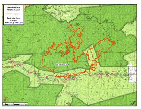
Situation as of 08/05/08 6:00 PM
Total Personnel: 322
Size: 32,590 acres
Percent Contained: 0%
Costs to Date: $2,050,000
No structures lost since 8/3. Yesterdays evacuations remain in place. Evacuations initiated today at Goff Creek and Libby Creek summer home groups. Evacuation re-established at the Elephant Head Resort.
A large plume column began building at 11:00am on the W end of the fire with activity continuing all day; growing to the S and W. Fire is now 6 miles from E entrance to Yellowstone NP.
***************
Situation as of 08/04/08 6:00 PM
Total Personnel: 288
Size: 31,050 acres
Percent Contained: 0%
Costs to Date: $1,370,000
Fire made a 9000+ acre run to the Northeast yesterday evening after 1900. The former Sweetwater Resort and a USFS structure were destroyed during the run. Evacuations continue. Strong winds anticipated.
***************
Update: The MMA (Maximum Manageable Area, or desired incineration zone) has been announced. It is 417,000 acres (652 sq miles) and includes public and private properties north and south of Highway 14. No map of the MMA was issued.
Situation as of 08/03/08 5:00 PM
Total Personnel: 200
Size: 21,995 acres
Percent Contained: 0%
Costs to Date: $1,000,000
Evacations are underway for the Elephant Head, Absaroka Lodge and summer cabins in Moss Creek. Fire came down to highway from the Sweetwater Creek drainage threatening cultural resources. Temporary road closure on the North Fork occurred.
Team transition to Type II (Angel) will occur at 1800 hrs. WFU is still main strategy. Hahnenberg will remain committed to complete stage 3 WFIP. One million dollars worth of “resource benefit” has been inflicted to date. Taxpayers, residents, visitors ecstatic. Numerous signs out in Cody WY, “Thanks for the Benefits.”
***************
Situation as of 08/02/08 5:00 PM
Total Personnel: 142
Size: 15,529 acres
Percent Contained: 0%
Costs to Date: $475,000
Evacuations are underway for the Elephant Head, Absaroka Lodge, and summer cabins in Moss Creek. Fire may have spotted over the North Fork.
Fire out of control. Firestorm, pluming. 100% mortality of forest. Threats to structures. Shut down of recreation. Despite that, Shoshone NF has announced that WFU is still main strategy. Hahnenberg FUM remains committed to complete stage 3 Wildfire Use Plan, even as the fire rages outside the previously designated Maximum Manageable Area.
Dimwit Shoshone Forest Supervisor Becky Aus, pictured [here], is legally responsible.
***************
Situation as of 08/01/08 5:00 PM
Total Personnel: 142
Size: 9,560 acres
Percent Contained: 0%
Costs to Date: $323,786
As predicted (below), the Gunbarrel WFU Fire is now close to 10,000 acres. Fire may breach the non-reported MMA this evening or overnight. Evacautions are underway for multiple lodges and homes within the North Fork area.
Fire managers are currently re-evaluating complexity analysis and developing Management Action Plans for appropriate management response. [sic - no kidding, that's what the report said, although I corrected their misspellings. Interpretation: the WFU idea has failed catastrophically. Another Let It Burn fire is blowing up. - Ed]. Two helicopters, 5 engines, and 50 firefighters have no chance of affecting this fire in any manner.
Fire is running, spotting and crowning downhill in the drainage of the North Fork. Fire is moving N and NE with runs up and down drainages, and creating significant growth toward the S as well.
Red Flag Warning for strong winds again tomorrow.
***************
Situation as of 07/31/08 5:00 PM
Total Personnel: 70
Size: 7,844 acres
Percent Contained: 0%
Maximum Manageable Area: not reported
Est date of containment: none
Red Flag Warning for strong winds today, 10 to 15 MPH increasing to 25 TO 30 MPH in the afternoon.
And thar she blows. Still no plan except let ‘er burn. Should be 10,000+ acres by evening tomorrow. Personnel in grave danger given the capabilities of the fire managers.
***************
Situation as of 07/30/08 5:00 PM
Total Personnel: 60
Size: 4,701 acres
Percent Contained: 0%
Maximum Manageable Area: not reported
Est date of containment: none
Continue to evaluate threats to MMA and developing Management Action Plans for appropriate management response. Meanwhile fire has quadrupled in size in two days.
Incident Command Post located at the Supervisors Office of the Shoshone National Forest, 40 miles away in Cody, WY. Shoshone NF was site of infamous Little Venus burnover of a Fire Use Module in 2006. No LCES led to near fatalities to 10 personnel.
***************
Situation as of 07/29/08 5:30 PM
Total Personnel: 28
Size: 2,103 acres
Percent Contained: 0%
Beginning WFIP Stage III process [they plan to make a plan]. Continue to evaluate threats to MMA and developing management action plans for appropriate management response. [Maximum Manageable Area indeterminate and subject to govt. functionary whim. The response chosen has been to watch gape-jawed as a few thousand acres per day are consumed by the fire. Eventually many $millions will be spent on a megafire and on the aftermath, damage that will last for decades].
Fire spotting ahead of fire front from wind-blown embers. Crown fire in forested areas. Fire spreading up side drainages in all directions.
***************
Situation as of 07/28/08 5:00 PM
Total Personnel: 14
Size: 800 acres
Percent Contained: 0%
Hannenberg’s Fire Use team has been ordered. FUT will assume control of the fire at 0600 07/29/2008.
Continue to monitor and take action if fire moves down drainage toward North Fork Shoshone River (Hwy 14) corridor. Fire backing into the wind in heavy timber and spotting to the east.
