Cold Springs Fire (with Badger Fire)
Location: 10 miles N of Trout Lake, Yakima Co., WA
Specific Location: Cold Springs, Mt. Adams area, Lat 46° 7´ 18″ Lon 121° 29´ 55″
Date of Origin: 07/13/2008
Cause: lightning, “sleeper” delayed ignition from week-old strike
Situation as of 07/29/08 4:30 PM
Total Personnel: 225
Size: 7,729 acres
Percent Contained: 98%
Costs to Date: $9,432,795
Heavy fuels continue to burn and smolder in the interior. No expected growth over the next 12-24 hours.
***************
Situation as of 07/27/08 5:00 PM
Total Personnel: 225
Size: 7,729 acres
Percent Contained: 98%
Costs to Date: $9,153,436
Acreage by ownership: Yakama Indian Reservation - 1,623 ac; Gifford Pinchot NF - 4,723 ac; Hancock Forest Management - 307 ac; Washington DNR - 1,076 ac.
Continue aggressive mop-up and cold trail of perimeter. Back haul equipment. Make preparations for rehabilitation.
*************
Situation as of 07/24/08 9:00 AM
Total Personnel: 948
Size: 7,980 acres
Percent Contained: 98%
Costs to Date: not reported, est. $8 million
On Friday, July 25, 2008, the Central Oregon Incident Management Team, led by IC Mark Rapp, will transfer command of the Cold Spring, Sheep Lake, and Big Lava Fire to a Type III Incident Management Team lead by IC Alan Lawson. The Big Lava Fire is on patrol status. The Sheep Lake Fire is being monitored by air.
***************
Situation as of 07/22/08 3:30 PM
Total Personnel: 1,042
Size: 7,980 acres
Percent Contained: 90%
Costs to Date: $7,523,887
One helicopter and reassigned two Type 1 crews from the Cold Springs Fire supported initial attack on a new fire start, the Badger Fire, on the Mt. Hood National Forest.
The Badger Fire is 15 acres and was contained last night around midnight. Location not reported.
***************
Situation as of 07/20/08 5:00 PM
Total Personnel: 1,096
Size: 7,980 acres
Percent Contained: 75%
Costs to Date: $5,237,455 (not updated)
Burnout of interior islands continue in Division E. Crews made good progress in all Divisions to meet mop-up objectives. Supported initial attack on two new starts on the Mt. Adams R.D. Four rappellers were used for initial attack on the Sheep Lake Fire.
RED FLAG WARNING IN EFFECT FROM 3 PM THIS AFTERNOON TO 5 PM PDT TUESDAY FOR ABUNDANT LIGHTNING ACROSS CRITICALLY DRY FUELS FOR FIRE. STORMS WILL CONTINUE OVERNIGHT AND THROUGH TUESDAY AFTERNOON AS THEY PROGRESS TOWARD NORTHEAST OREGON. SOME OF THESE STORMS MAY PRODUCE STRONG OUTFLOW WINDS.
***************
Situation as of 07/19/08 4:00 PM
Total Personnel: 1,128
Size: 7,956 acres
Percent Contained: 60%
Costs to Date: $5,237,455
Acres by ownership: Yakama Indian Reservation - 1,529. Hancock Forest Management - 643. Washington DNR - 1,104. Mt. Adams RD, Gifford Pinchot NF - 4,670.
Burnout of interior islands was completed in Division C and initiated in Division E. There was no perimeter growth in the last operational period so acres burned remain at 7,956. Occasional torching, short range spotting, some located N of fire line, some created from original 7/13 burn period.
A Long-Term Assessment Team was assigned to the incident to develop a plan to manage the fire through the remainder of the summer.
***************
Situation as of 07/18/08 5:00 PM
Total Personnel: 1,086
Size: 7,956 acres
Percent Contained: 50%
Costs to Date: not reported, est $4.4 million
***************
Situation as of 07/17/08 5:00 PM
Total Personnel: 1,037
Size: 7,933 acres
Percent Contained: 30%
Costs to Date: $3,239,632
***************
Situation as of 07/16/08 5:00 PM
Total Personnel: 930
Size: 7,604 acres
Percent Contained: 18%
Costs to Date: $2,243,698
20 miles of line construction was completed. No significant fire growth despite high temps, low humidity, and strong Gorge winds. Active torching and spotting as interior fuels continued to burn throughout.
Briefing with Yakama Tribal counsel on 7/17. Community meeting held on 7/15 with
the community of Trout Lake. On-going communication with Yakama Tribe, Washington DNR,
and Hancock Forest Management.
Note: The CO2’s (Central Oregon Type II IIMT, Rapp) accomplished more in one day than many IMT’s fighting California fires have accomplished in a month. When a good team wants to contain a forest fire, they do so. When a poor team wants to milk a fire for weeks or even months on end, well, that apparently happens, too.
***************
Red Flag Weather Warning in effect until 10 PM PDT Wednesday. NW winds 11 to 18 mph with gusts to 35 mph, becoming west 5 to 10 mph after midnight. In the E Columbia River Gorge W winds 14 to 21 mph with gusts to 35 mph decreasing to 6 to 11 mph after midnight.
Situation as of 07/15/08 6:00 PM
Total Personnel: 518
Size: 7,160 acres
Percent Contained: 5%
Costs to Date: $1,210,301
Fire is moving E to NE with short range spotting, active torching, and runs of 1-2 miles.
Line building is in progress. Central OR Type 2 IMT (Rapp) assumed command of the incident on 7/14/2008 at 2000. On-going communications with Yakama Tribe, Washington DNR, and Hancock Forest Management.
***************
Situation as of 07/14/08 6:00 PM
Total Personnel: 335
Size: 8,000 acres
Percent Contained: 0%
Costs to Date: $200,000
Fire active throughout night with spread towards the Bird
Creek meadow area. Crews and dozers worked to secure private lands adjacent to Forest and Yakama Agency lands on 7/14. Burnout operations underway.
Red Flag Warning in effect until 10 pm PDT Wednesday for winds and low humidities. Eastern WA and OR. West winds 6 to 11 mph increasing to NW 12 to 19 mph in the afternoon. In the eastern Columbia River Gorge west winds 7 to 12 mph increasing to 15 to 22 mph in the afternoon. Gusts to 35 mph.
***************
Situation as of 07/13/08 9:00 PM
Total Personnel: 237
Size: 2,000+
Percent Contained: 0%
Evacuation of Climbers at Cold Spring Trailhead and Climbers on on Mt Adams. All Forest Roads closed east of Forest Road 25. All Trails on eastside of Mt. Adams closed at this time.
Central Oregon IMT2 (Rapp) ordered for 07/14/08.
Fire very active tonite making a major run to the east at 2100. Fire
spotting 1/2 mile out from main fire. torching of groups of trees.
***************
Situation as of 07/13/08 3:00 PM
Total Personnel: unknown
Size: ~100 acres (500+ acres at 6:00 PM)
Percent Contained: 0%
Two air tankers and a helicopter have been flown. Access closed to the Cold Springs South Climb trailhead and all hikers are being evacuated from the area. Large smoke plume visible for many miles. (217 registered climbers on Mt. Adams today. Autos parked at trailhead are at risk. USFS attempting to notify all climbers and have autos removed by Sunday evening.)
Note: Trout Lake is in Klickitat Co., but the fire (at this point) is in Yakima Co. on the Gifford Pinchot NF, not Yakima Indian Res., close to and possibly in the Mt. Adams Wilderness Area. Thick forest, much dead and down from various pathogens, heavy fuel loading.
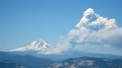
Cold Creek Fire from upper Hood River Valley, 07/13/08. Photo courtesy John Marker.
by Rachel
Mt. Adams Wildfire…
According to KGW, the Mt. Adams wildfire can be seen from downtown Portland, it can be seen quite easily from my front porch: (Click the image for a full size picture) Update: Other coverage: King 5OregonLiveThe ColumbianKATU (really good pictures)……
by tdub
Was hiking back from Bird Crk Mdw/Mazama Glacier area early yesterday and saw the small area of smoke as I headed down… Was glad to be able to get to the car and get down. At the time, it all seemed manageable, but the fire sure took off in the afternoon. Hoping the impact to trails and high country access won’t be too dire, but it’s not looking good.

We were just camping this weekend at Mirror Lake, which is about 4 miles from the fire. Although the ground was still wet, and there were still patches of snow on the ground, we were amazed at the amount of “fuel” in the area. (Down trees, dried branches etc).