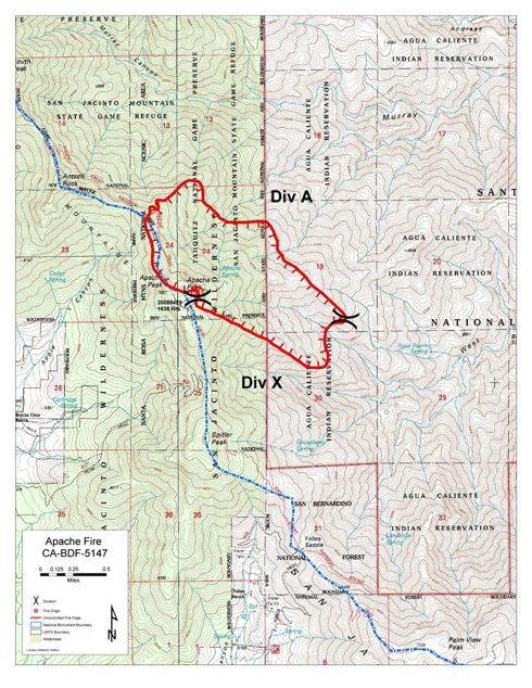
Apache Fire
Location: San Jacinto Wilderness, San Bernardino NF, Riverside County, CA
Specific location: Apache Peak near the Pacific Crest Trail, about six miles east of the Riverside County community of Mountain Center.
Date of Origin: 04/29/2008 at 1635 hrs.
Situation as of 05/04/08, 7:00 PM
Total Personnel: 328
Size: 784 acres
Percent contained: 100 %
The Apache Fire was declared 100 % contained this afternoon. Firefighting personnel are being pulled out. The PCT and the San Jacinto Wilderness are closed from Saddle Junction south to Highway 74, but that closure will probably be lifted sometime tomorrow.
***************
Situation as of 05/03/08
Total Personnel: 731
Size: 784 acres
Percent contained: 64 %
Estimated Containment Date 05/04/2008 at 1800 hrs.
Notice 05/03/08 AM: The San Jacinto Wilderness is open from Devil’s Slide Trail northward, includng the PCT. The PCT and the San Jacinto Wilderness are closed from Saddle Junction south to Highway 74 due to the fire. Mt. San Jacinto State Park is open. The Palm Springs Tramway and adjacent Long Valley are open.
***************
Situation as of 05/02/08
Total Personnel: 721
Size: 784 acres
Percent contained: 64 %
Estimated Containment Date 05/04/2008 at 1800 hrs.
***************
Situation as of 05/01/08 (updated)
Total Personnel: 711
Size: 784 acres
Percent contained: 25 %
Resources assigned include 30 handcrews, 2 helicopters, 2 helitankers, and 4 fixed wing aircraft.
***************
Situation as of 04/30/08
Total Personnel: 170
Size: 700 acres
Percent contained: 0 %
Fuels: Heavy brush, some timber, dead and down.
Fire Behavior: Rapid rates of spread.
Summary: Due to steep roadless terrain, 9 handcrews hiked into fire this morning. High winds, smoke and steep terrain have made accessing fire difficult. Aircraft were grounded due to high winds and a heavy marine layer limiting visibility this morning but have been flying this afternoon.
Growth Potential: Extreme.
Current Wind Conditions: 40 mph W
Current Temperature: 54 degrees
Current Humidity: 40 %
Air support expected to make progress on Apache fire Thursday
Fire crews attacking fire with five aircrafts, digging containment lines
by Colin Atagi and Angela Franzer, The Desert Sun [here]
Fire crews are expected to continue an air assault Thursday against a 700-acre wildfire that’s been burning near Idyllwild in the San Jacinto Mountains since late Tuesday afternoon. The blaze is about 2 miles from homes in Palm Springs.
Firefighters are using five aircraft to drop water and retardant on the blaze.
“If we can use air support, we’ll be in good shape,” U.S. Forest Service spokeswoman Kate Kramer said. “The winds have died down. Our weather outlook looks better (Thursday).”
Today’s 20-mph winds and 40-mph gusts that caused problems were expected to drop to less than 10 mph Thursday, National Weather Service Meteorologist Ted MacKechnie said.
“All in all, I think (the fire is) going to become more manageable,” he said.
As of 8 p.m. tonight, firefighters had zero containment on the blaze, which was first reported about 4:30 p.m. Tuesday. …
Smoke from the fire has engulfed Palm Springs this afternoon, but all Coachella Valley hospitals have not received reports of any respiratory ailments from local residents.
At least 170 fire personnel have been called in to battle the blaze.
Cal Fire officials have dispatched at least 125 firefighters to assist.
Planned air attacks were delayed earlier because weather conditions would be dangerous for pilots. …
AsABat is all over it:
While it appears a little progress has been made on the fire on Apache Peak (Section B), the closure now extends from Highway 74 at least as far north as the wilderness boundary on Fuller Ridge. Therefore, it appears a detour by highway and Black Mtn Rd to the Fuller Ridge Trailhead is required.
Official posting: The San Jacinto Wilderness and Mt. San Jacinto State Park are closed until further notice. The Devil’s Slide, Spitler Peak, Southridge, Fobes Ranch, and Cedar Springs trails and a section of the Pacific Crest Trail [nobo from Hwy 74] are closed until further notice. Full containment predicted for May 7, 2008.
Info sources:
http://www.inciweb.org/incident/1236
http://mtsanjacinto.info/viewforum.php?f=1
http://www.mydesert.com
http://www.towncrier.com
Halfmile’s topo maps
http://www.pctmap.net/pctdownloads/sanjac_detour_map.zip
San Bernadino NF maps
http://www.fs.fed.us/r5/forestvisitormaps/sanbernardino/
[Mike, this is a big deal for north bound thru-hikers most of whom are about to enter this area in a big pack.]
Wayne,
My judgment is the following. There are 711 personnel in 30 hand crews on the fire, which is 784 acres. That is a lot of people for a fire of that size. Containment went from 0 to 25% today. Winds are breezy, 30mph NE reported on the ridge, but humidity is high, 40%. The PCT is on the west edge of the fire, which is where it started, and the fire is moving slowly downhill to the east and south.
I suspect the PCT is not in a fire hazard condition now, though it may be very smoky. It may also be jammed with firefighters. Hikers do not want to interfere with fire suppression operations, but those operations may be largely completed in a day or two. The closure may linger longer than that, however. I do not foresee backfiring. There is no reason for that on this fire.
North bounders arriving in the vicinity in the next two days should take the detour. Those arriving in 3 or 4 days may be able to stick to the trail. Those are my guesstimates.
The fact that USFS jumped all over this fire was a good decision. It means they will spend a lot of money per acre keeping it small, but the other option, letting it burn, would have cost magnitudes more in total when it (potentially could have) swept down into Palm Springs.

The Apache Fire is on the Pacific Crest Trail. The following comments were excerpted from PCT chat sites by “trail angel” Wayne Kraft of Portland.
*******************************
I hiked from Saddle Junction to Spindler Peak Trail (just south of Apache Peak) on Monday 4/28/08. The trail still has a lot of snow from Saddle Junction to about four miles south. There is still an ice cornice just north of Apache Peak which is difficult, but doable without an ice ax. The snow nearer Saddle Junction is deep, soft, and melting fast. I did it all with just a hiking pole. There are plenty of hikers getting through to Saddle Junction, and there is some navigation difficulty near S Fork of Tahquitz Cr. Lots of prints to follow.
Tonight’s local news reports a forest fire in the area around Apache Peak. This looks like it is right on the PCT. Sadly, it appears that this may have been started by a hiker (the weather has been clear, no lightning). I would advise hikers approaching the Pine to Palms highway to check with the local ranger district for further details.
*******************************
There is a fire, about 300 acres in size, near Apache Peak. Devil’s Slide and South Ridge trails are both closed. The cause of the fire is unknown. The Forest Service recommends that you come off the PCT at Hwy 74 and come into Idyllwild until the fire has been contained.
*******************************
Here’s a [PCT] Google Map centered on Apache Peak:
http://tinyurl.com/6db9av
Postholer.com
*******************************
The PCT is now closed from Highway 74 to Devil’s Slide. The fire was reported by a hiker at about 5 p.m. yesterday Tuesday. The winds up there are gusting to 60 mph, so as of noon today Wednesday, the fire-fighting effort is delayed. Idyllwild is getting smokier by the minute. The Forest Service is posting signs for trail closure, but may miss some hikers. Devil’s Slide Trail may close also.
*******************************
Suzanne W. talked with USFS this morning and Devils Slide Trail was closed but the PCT was open at that time. (Yes, we agreed that made no sense.) Given the fire is now 700 acres and burning on the south side of Apache Peak I’m sure the PCT must be closed (or at least impassible). Another report had hikers taking a side trail down away from the fire.
I’m trying to keep short trail closure updates on the water reports page, but the links below may be more informative:
http://www.inciweb.org/incident/1236
http://www.mtsanjacinto.info/viewtopic.php?t=846
http://www.mydesert.com
http://www.towncrier.com
AsaBat [who deserves credit for many of the comments herein]
*******************************
Now is a good time to get on my fire prevention soap box just for a bit. Two of the main factors that influence fire spread in wildland fires are 1. wind, 2. slope. Fires tend to burn with the wind and uphill. The Apache fire had no where to go but uphill and with a good wind on it.
Any time the wind is blowing strong enough to blow ground litter around such as leaves, that’s a good time to refrain from lighting any ignition source e.g.match, bic lighter, alcohol stove, cigarrette, or burning your toilet paper.
On the back of your California Campfire Permit there is a section on Liability referencing the Calif. Health and Safety Code 13009 which says “You are liable for the cost of suppression and damages caused by any wildfire that starts through your negligence.”
The Apache fire will probably go on the better part of a week and it’s going to run up quite a large tab. One that few of us would be able to afford. On the front of the permit two of the four requirements for having a campfire, which includes the cool little stoves we use, are a minimum of 5 ft. clearance in all directions and to have a shovel available at the site. In the wind 10 ft of clearance is probably not adequate & most of us won’t have the latter. I intend to leave mine at home. It’s just way too heavy.
So before lighting the fire just take a look around and check the wind conditions and the slope you might be on. Then if you err, err on the side of safety and enjoy a cold meal. — traildog — Fire Captain Retired, CDF
*******************************
Check out this new fire tracking website:
https://westinstenv.org/firetrack/
Unfortunately, it may see lots of use this summer.