Payette NF Roads Wash Out
Note: the following courtesy the Yellow Pine Times, an email-only publication. Central Idaho has been hit by heavy rains, causing flash flooding of numerous rivers. More rain and more floods are expected next weekend.
By Ned Pence, Yellow Pine Times, June 7, 2010
It is interesting for me to read the reporting in your Yellow Pine News. I remember the flood of June 1974. That flood was the result of a heavy winter snow pack and a cool spring until June. The June runoff was regulated by the weather. The SFSR (South Fork Salmon River) was very high for most of June. There was no damage to the road because the runoff was weather regulated; however, it was in June 1974 that the Oxbow at Teapot was breached indicating that the runoff was a record. The weather regulated runoff flushed the logging related sediment out. We had completed closing several logging roads that had been a problem. Logging had affected about 15% of the SFSR and the sediment problem was a result of problem logging roads that had not been closed. The SFSR looked very good after the runoff.
The 2010 flood is much different since there was not a heavy snow pack. It is the result of heavy spring rains that saturated the soil at a time when the soil damage from the 2007 fires has not healed [here]. The 2007 fires affected almost the entire SFSR drainage. This years flood is a flash flood and not regulated by weather. The runoff is occurring over a very short time. It will be interesting for me to observe the effect on the fire related sedimented condition of the SFSR later this summer.
The Idaho Batholith granite soils are fragile as evidenced by the steep, river-formed landscapes that developed over many centuries. However, the fire events starting in the 1990s are unprecedented in historic times due to the fuel loading that was evident to me when I was DFR.
I am also concerned that there will be a desire in the Forest Service to not rebuild the road and to close it. There was a desire in the 1980s to close the road until Senator McClure obtained the funds to solve the sediment problem the road was causing. That rebuilding was very successful. The current problems is not due to the roads. The problem is caused by fuel loading and resulting fire. Without active management the problem will not stop.
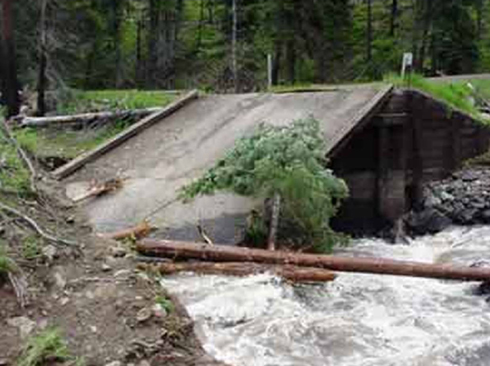
East Fork Weiser River Road Bridge Collapse, photo courtesy Payette NF
Heavy Rain Causes Damage on Payette National Forest
Payette National Forest News Release, June 7, 2010
The large amount of rain we’ve received on the Payette National Forest has damaged campgrounds and roads. Additional damage is being discovered by forest personnel as they patrol the forest. Alerts will be posted on the Forest Home Page at http://www.fs.fed.us/r4/payette/ but people should call the Ranger Districts as conditions change before undertaking any camping or other activities on the forest. …
Krassel Ranger District:
The lower end of the South Fork Salmon River Road (SFSR RD.) is closed at Buckhorn Creek. The road has washed out for about 100 yards below the confluence. The road will remain closed until this significant damage can be repaired.
The SFSR Rd. at Fitsum Creek below the Krassel Work Center is in danger of washing out and the Valley County Road Crew is assisting the Payette National Forest to stabilize the road and prevent it from completely washing out. …
Weiser Ranger District:
Brownlee Campground on is closed until further notice. E. Fork Brownlee Creek at and just above the Brownlee Campground has washed over the road above the campground and washed tremendous ruts down the road. …
Spring Creek Campground may be flooded and forest personnel are on site assessing the situation.
McCall Ranger District:
Upper Payette Campground remains closed due to snow and rain.
There is a massive logjam on Rapid Creek on the McCall Ranger District near road #388. …
Road #401 in the Paddy Flat area near the junction with road #388 is washed out and impassable at this time. The missing section of road is about 27 feet long.
The Valley County Road Department reports the following:
The East Fork South Fork Road and Johnson Creek Road are open.
Access to the Warren and Burgdorf area is via Eastside Drive. Warren Wagon Road is closed at Dead Horse Creek and will be closed indefinitely.
Access to North Beach and Francie Wallis Park from Eastside Drive is partially washed out and only one lane is passable. Please use caution in the area.
Please call the Valley County Road Department for the latest information on county roads at 382-7195.
More Reports of Damage as Reports from the West Side of the Forest Come In
Payette National Forest News Release, June 08, 2010 [here]
Council Ranger District:
East Fork Weiser River Road #172 is closed. The first bridge one half mile from the junction with Hwy. 95 is completely destroyed and impassable. …
Mill Creek Road #165 is closed due to a dangerous situation. The twin culverts are totally plugged about 1-2 miles from the forest boundary. Heavy flows are running across the road and down and inside the borrow pit. …
The Middle Fork of the Weiser River Road #186 is closed at Boulder Creek. The bridge is totally destroyed. …
SF SALMON RIVER Gauge
LOCATION: Valley County, Teapot Mountain quad., Payette National Forest, on right bank 0.6 mi upstream from Fitsum Creek, 1.4 mi downstream from Krassel Ranger station, 2 mi upstream from mouth of East Fork of South Fork Salmon River, 20 mi east of McCall, and at mile 39.7.
EXTREMES FOR PERIOD OF RECORD. — Maximum discharge, 6,740 CFS June 17, 1974, gauge height, 10.00 ft.
EXTREMES OUTSIDE PERIOD OF RECORD. — Flood of May 28, 1948, reached a discharge of 5,200 CFS as determined by slope-area measurement at site 2.3 mi upstream.
Most recent instantaneous value: 06/06/2010 19:45 MDT 4,380 CFS, 7.90 (feet)
Note: The recorder went off line June 3 through part of June 5th, but when it started transmitting again it read: 06/05/2010 12:45 MDT 9.28 (feet) and 06/05/2010 13:00 MDT 6,070 CFS - Yellow Pine Times
by YPmule
We have had big run offs before, however the old timers say that it was nothing like these slides and blowouts. Ironic that the reports of damage are coming from areas that burned. The South Fork of the Salmon burned in 2006 and again in 2007. We are still receiving reports of damage as they are found.
Thanks for posting this Mike.

2010 is just an anomaly. A spastic reflex in the algore climb to global heating. There was no snow this winter, so all that water has to be from a “stuck” thunder storm. Or some other anomaly. And I have a bridge in Brooklyn I can sell you.
I am sick and tired of saying “don’t-you shouldn’t-that won’t work” til the cows come home. And being shushed as the person who is disruptive and not understanding of how the new world really works. So I am not saying “told you so—told you so” a zillion times.
You can’t take people out of the environment they created and preserve it. You can’t loan money to people who can’t pay it back and depend on government to cover the bad loans. You can’t export your jobs, outsource your information work, and import the stuff of life forever, because you will run out of other people’s money. And, like the spring freshet that is wiping out roads and bridges, there is nothing a sane person can do about any of it.
The urban majority in the New West is very much composed of the urban majority of the East Coast who have moved. Or of the Midwest cities they have migrated from. How many people who were raised in Oregon or Idaho or somewhere in the New West go swimming in spring runoff? The pilgrims do and die every hot day. This weekend it is supposed to get to 80. There will be drowned people by Monday. There will be somebody lost climbing a mountain the day the next storm moves in. Some pilgrim will get lost in the Gorge on a well-trailed area of cliffs and waterfalls. A kayak or raft will tip over on a spring freshet stream and someone will drown. Or a beach goer will get washed off some rocks, or a log will roll over somebody. A boat will sink. Maybe more than one. It never changes for the better, but only gets worse.
And the idiots are the very ones who allege to know all about protecting forests and how they are ecosystems and how all the critters are not helped by logging… and sho’ nuff, a fire comes through, kills all the very same critters, reduces their habitat to zero, and the same people are telling you what a wonderful deal this is, this stand replacement fire. Something had to rid the forest of that fuel load, and fire does it best. Hell, and here I thought nuclear holocaust would do a better job… It would first lay it all down, and then burn it all radioactively. That way you don’t get snags to endanger hapless hikers down the road… But what do I know?