The Ozette Prairies of Olympic National Park: Their Former Indigenous Uses and Management
M. Kat Anderson. 2009. The Ozette Prairies of Olympic National Park: Their Former Indigenous Uses and Management. Final Report to Olympic National Park, Port Angeles, Washington Winter 2009.
Full text [here] (3.2 MB)
Selected excerpts:
Introduction
The Ozette Prairies—openings of bog, fen, and grassland in a forest of Sitka spruce, western hemlock, and western redcedar—lie two kilometers east of the Pacific Ocean, well within hearing distance of barking sea lions on the rocky islands offshore. One can walk from these wetlands to the coast on the Cape Alava Trail, which cuts through the openings and the surrounding forest along the route of an old Indian trail (Waterman 1920). Wandering off the trail into the forest, the travel becomes slow and cumbersome; one has to straddle downed logs and bushwhack through shrubbery and young trees.
The wetlands, on the other hand, are easily and comfortably traversed. They are inviting landing sites for ducks and geese, habitat for ground-nesting birds, and are attractive to Roosevelt elk, blacktailed deer, and black bears. Before the coming of white settlers, they were also attractive to the Ozette Indians, who hunted and collected food and useful plants there for perhaps 2,000 years (Blinman 1980; Wessen 1984). The Ozette people would come to the Ozette Prairies from their village at Cape Alava on the Pacific Ocean, seeking young horsetail sprouts to eat in spring, the leaves of a particular sedge to weave into their baskets in summer, and bog cranberries, Indian tea leaves, and fern rhizomes in autumn.
They built shelters in the wetlands and dried and smoked their food there (Bertelson 1948; Gunther 1871-1981). Before 1910, two Swedish immigrants—Peter Roose and Lars Ahlstrom—filed 160 acre claims and moved onto these open areas, built structures, raised sheep and cattle, and planted vegetable gardens (see Figures 1 and 2). When Ahlstrom first moved to the area in 1902, he lived in an Ozette Indian hut and interacted with the Ozette as described by Bertelson (1948): “He got along fine with the Ozettes, and bought salvaged drift-boards and planks from them with which to build. And after he got settled and had acquired four cows, he traded butter and garden truck with the Indians for fish and game.”
Today, butterfly and plant experts view the Ozette Prairies as a wilderness refuge — a place sheltering unique plant and animal life. They are a biological focus area of the National Park Service because they represent excellence in beauty and biological diversity and harbor an array of rare and endangered plant and animal species (http://www1.dnr.wa.gov/nhp/refdesk/lists/plantrnk.html; Pyle 2002). In recognition of their cultural and ecological value, the wetlands have received official protection; their structures are on the National Register of Historic Places and the land is designated as wilderness or potential wilderness (Washington Park Wilderness Act of 1988; Ruth Scott pers. comm. 2007).
But formal designation alone is not enough to save the biotic diversity of these areas, as they are shrinking. Young western hemlock and redcedar trees, along with some Sitka spruce and Pacific yew, are advancing into the open habitats (see Figure 3). In the early 1940s, Alice Kalappa, Makah, complained to anthropologist Elizabeth Colson in an interview that “Now there are lots of trees on the [Ozette] marsh because nobody takes care of it anymore.” In 1981, Stephen Underwood, Ozette Subdistrict Ranger, wrote Olympic National Park visitors to solicit early photographs of the Ahlstrom’s Prairie. He received slides and prints of Ahlstrom’s Prairie from the early 1960s. He wrote the visitors thank you notes saying in one letter that “It’s impressive how much growth has occurred out on the prairie [between the early 1960s and 1981]” (Underwood 1981). Wetlands ecologist Linda Kunze documented tree encroachment on the Ozette Prairies in her unpublished botanical field notes in 1989 (see Appendix 1). Ed Tisch (2002:6) explained the tree encroachment onto Ahlstrom’s Prairie in an article in the Voice of the Wild Olympics magazine:
The highest, best-drained sites favor tree establishment. Most of these elevated areas currently support a hemlock\salal-evergreen huckleberry community type in which bracken, deer ferns, bunchberries, twinflowers, and beaked mosses are common, and the dominant shrubs grow to heights of three to ten feet. These expanding ‘forests’ are slowly repossessing.
Cultivated Landscapes Cultural Landscapes Fire History Native Cultures The Wilderness Myth
by admin
Comments Off
Before Columbus: The Americas of 1491
Charles C. Mann and Rebecca Stefoff. 2009. Before Columbus: The Americas of 1491. Atheneum Books for Young Readers, Simon & Schuster.
Available [here]
This book should be in every school.
The study of historical human influences on the environment is hampered by stubborn adherence to myths and falsehoods developed in childhood. Schools teach that Native Americans were few, savage, and insignificant wandering nomads who lived in a wilderness before Europeans arrived to tame the Americas.
Charles C. Mann’s 2005 bestseller, 1491: New Revelations of the Americas Before Columbus [here], exploded many of those myths. He essayed the new, developing ideas and evidence regarding pre-Columbian America indicating that the Western Hemisphere was populated by millions of people living in civilizations older and more advanced than those of the invading Europeans.
Now Mann and co-author Rebecca Stefoff have adapted 1491 into a book for school children. Before Columbus: The Americas of 1491 is a gorgeous “coffee table” book filled with vibrant pictures and a text that is exciting and understandable for younger scholars.
Teachers and parents take note. Don’t let your kids grow up to be ignorant of their roots. The landscapes we live in have been cultural landscapes, shaped by humanity, for thousands of years. The heritage of place is your heritage and that of your children.
Part One of Before Columbus: The Americas of 1491 examines the question “How Old was the New World?” Archaeologists keep pushing the date back, but without a doubt human beings were living throughout the Americas 10,000 years ago (8,000 BC). The first cities may have been along the Peruvian coast. The pyramids at Huaricanga are at least 5,500 years old. The residents also built irrigation canals to water cotton fields, from which they made nets to harvest fish. Ancient mariners sailed far out into the Pacific to net anchovies, sardines, and other fish. Their cultural stamp (the distinctive gods carved on gourds) can be seen in rock carvings and temples crafted thousands of years later at Lake Titicaca, the cradle of Incan civilization.
Part Two asks “Why Did Europe Succeed?” and includes four chapters on “The Great Meeting” (Cortez and the Aztecs at Tenochtitlan), “Long, Long Ago” (the first Americans, the PaleoIndians, and Monte Verde in Chile), “Extinction” (the demise of the megafauna, including mammoths), and “Disease-Free Paradise? (the impact of European disease on the Native Americans).”
Part Three examines “Were the Americas really a Wilderness?” It’s chapters include “Amazonia” with discussion of the fruit and nut orchards found across the Amazon Basin and the anthropogenic soils called terra preta. “Land of Fire” discusses the way in which Indians maintained a living anthropogenic mosaic of prairies, savannas, and open, park-like forests, principally through the use of controlled burning. In “The Created Wilderness” the authors explain how those human-shaped landscapes were abandoned when the Indian populations nearly disappeared following the introduction of Old World diseases.
We cannot plan for the future if we do not understand the past. Forests cannot be cared for, and the desired future conditions cannot be achieved, if we do not have a firm grasp on how our forests developed in the first place.
Mann and Stefoff seek to instruct our youth with the truth, so that as adults they can make informed judgments about environmental stewardship.
Buy this book. Better yet, buy a dozen copies and donate them to your local schools. Raise the consciousness about the distant past so that our coming future is guided by knowledge instead of myth.
The Alseya Valley Prairie Complex, ca. 1850: Native Landscapes in Western GLO Surveys
Bob Zybach. 2001. The Alseya Valley Prairie Complex, ca. 1850: Native Landscapes in Western GLO Surveys. IN Changing Landscapes: Proceedings of the 5th and 6th Annual Coquille Cultural Preservation Conferences 2001 and 2002, Don Ivy and R. Scott Byram (eds.), Coquille Indian Tribe, North Bend, Oregon: 161-188.
Full text [here]
Selected excerpts:
Editor’s note: Over the past several years researchers and land managers in numerous fields have begun to recognize what many Native people have been saying for a long time; the ecological landscape in western Oregon reflects the influence of the judicious use of fire and other plant management techniques. Despite this recognition, relatively little research has been done to explore the diversity of techniques Native people used to nurture the region’s ecological mosaic. Bob Zybach applies his broad knowledge of forest ecology and historical records in assessing the extent and variety of traditionally-tended plant communities in and around the Alsea Valley. He shows us that U.S. land survey records hold crucial, but largely untapped data for research on historic Native land use. — R. Scott Byram
TODAY there is a strong interest in rediscovering the nature and extent of historical Indian land use patterns in western Oregon. Knowledge of past environmental conditions and American Indian resource management actions can prove beneficial to developing wildfire control strategies (Boyd 1999c:293; Williams 2000:45-47), preservation of threatened and endangered species (Pendergrass 1996:227), recreation and maintenance of significant cultural landscape patterns (Winkler and Bailey 2002:2-3), and logging and reforestation planning (Wakefield 1988: personal communication).
Researchers and land managers have attempted to distinguish the effects of ecosystem management practices used by Native people historically, from the “natural variability” of ecological landscapes (e.g., Vale 2002). To what extent did historical landscapes reflect peoples’ influence as well as other ecological processes? This knowledge is seen as key to the successful management of natural resources in western Oregon, where Native communities interacted closely with a complex ecosystem that has undergone drastic changes since European-American (“White”) settlement began in the early 1800s. Knowledge of historical environmental conditions is needed as a baseline for this research (Schulte and Mladenoff 2001:5). Such conditions can be estimated or documented for the lands of western Oregon by a number of methods, depending on the time period, scale, and specific location in question (Zybach 1992).
The abrupt transformation of land management practices that occurred in western Oregon in the early and middle 1800s makes this a particularly critical period to understand. Over scarcely more than a generation, diverse Indian societies were largely replaced by a population of White immigrant farm families. The catastrophic loss of Indian lives, knowledge, and land use practices through introduced diseases in the late 1700s and early 1800s, coupled with a corresponding invasion of foreign cultures, plants, animals, people, philosophies, and technologies, resulted in a landscape that was forever altered (Boyd 1999a; Robbins 1997:23-49). General Land Office (GLO) surveys completed throughout western Oregon between 1850 and 1910 provide an exceptional source of information for documenting the transition of environmental conditions from traditional Indian land management practices to introduced European practices. Although these surveys were performed during the early 1850s and after, they can also be used to make reasonable estimates of environmental conditions at the time of contact (used here to mean the first documented contact between Indians and Whites for a given area), or even earlier.
This article considers the Alsea Valley and Alsea River headwaters of the central Oregon Coast Range (see Map 1) and examines information contained in early GLO surveys for that area (see Map 2). …
Bighorn hunting, resource depression, and rock art in the Coso Range, eastern California: a computer simulation model
Alan P. Garfinkel, David A. Young, Robert M. Yohe II. 2009. Bighorn hunting, resource depression, and rock art in the Coso Range, eastern California: a computer simulation model. Journal of Archaeological Science 37 (2010) 42–51.
Full text [here]
See also: Garfinkel, Alan P. 2007. Paradigm Shifts, Rock Art Studies, and the “Coso Sheep Cult” of Eastern California. North American Archaeologist, Spring 2007. [here]
Selected Excerpts:
Abstract
The extraordinary record of prehistoric rock art depicting tens of thousands of animal images in the Coso Range of eastern California provides an opportunity to study the relationship between aboriginal hunting, forager ecology, bighorn prey population levels, and the production of rock art. We review archaeofaunal evidence that the Coso desert bighorn sheep population was strongly depleted during the Newberry era after 1500 B.C. We discuss the dating of the rock art and show a correlation between bighorn depletion and increased rock art production. These data are consistent with the arrival of Numic foragers ca. A.D. 600 who competed with the Coso Pre-Numics and eventually terminated the Coso rock art tradition. An ecological predator-prey computer simulation of the human populations (Numic and Pre-Numics), the sheep population, and the rock art ‘‘population’’, demonstrates these proposed interconnections and gives a reasonable fit to the observed rock art production rate. …
Introduction
The Coso Range of eastern California has been occupied by humans since the Paleoindian period. The early inhabitants of the area left pecked rock images in very large numbers. Beginning roughly 2000/1500 B.C. and ending about A.D. 1300, aboriginal people left an elaborate record of hunting scenes with bighorn sheep (Ovis canadensis) as their prey. Over time the images become more naturalistic or realistic, larger in size and the image count increases remarkably during its peak period of production and then inexplicably at its peak after about A.D. 1300 the art ceased being produced. There are at least 100,000 individual rock art images represented in the Coso petroglyph record and it is estimated that about half are depictions of bighorn sheep. The Coso Rock Art Complex is one of the largest concentrations of rock drawings in all of North America.
Such a striking array of naturalistic or realistic images is very unusual for the Desert West and this startling record begs explication. Early researchers posited that the tremendous numbers of bighorn representations were indicative of vast herds of bighorn sheep that occupied the area in the distant past. Prehistorians implied that periods of peak sheep hunting correlated with the greatest abundance of bighorn rock art images. Prehistoric animal images were part of a bighorn sheep cult. These images figured in increase rites designed to ensure the return of game animals, human, plant, and animal fecundity, and the health and well-being of the Coso people and their way of life (Garfinkel, 2006; Grant et al., 1968; Hildebrandt and McGuire, 2002; Heizer and Baumhoff,1962).
This paper provides a population estimate for the metapopulation (a group of spatially separated or isolated animals that occupy a fragmented habitat, have limited exchange of individuals, and consist of a number of animal groups that interact in a restricted geographic area) of Coso bighorn and simulates the population dynamic of the local herds in light of human predation. It evaluates the proposition of whether it is possible that bighorn were over-harvested and depleted. Archaeofaunal data are adduced to provide a timeline, trajectory, and independent evaluation of the plausibility for bighorn resource depression. It also posits that the Coso inhabitants were seeing population pressure and conflicting land use issues from the neighboring Numic groups to the north moving into their territory from the Owens Valley. Standard ecological competition and predator-prey models are applied to simulate human and sheep populations. The simulation models sheep hunting across time and also models rock art production.We develop a model of the competing Numic and pre-Numic exploitation and land use strategies and close by providing a partial explanation of why the Coso Range was such an extraordinary focus of rock art expression. …
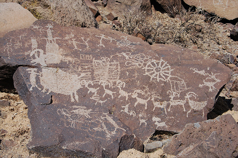
Fig. 2. Coso Representational rock art, Coso Style sheep, bowmen, and more ancient,
patinated abstract and geometric petroglyph elements.
Origins and antiquity of the island fox (Urocyon littoralis) on California’s Channel Islands
Torben C. Rick, Jon M. Erlandson, René L. Vellanoweth, Todd J. Braje, Paul W. Collins, Daniel A. Guthrie, and Thomas W. Stafford Jr. 2009. Origins and antiquity of the island fox (Urocyon littoralis) on California’s Channel Islands. Quaternary Research 71 (2009) 93–98.
Full text [here]
Selected excerpts:
Abstract
The island fox (Urocyon littoralis) is one of few reportedly endemic terrestrial mammals on California’s Channel Islands. Questions remain about how and when foxes first colonized the islands, with researchers speculating on a natural, human-assisted, or combined dispersal during the late Pleistocene and/or Holocene. A natural dispersal of foxes to the northern Channel Islands has been supported by reports of a few fox bones from late Pleistocene paleontological localities. Direct AMS 14C dating of these “fossil” fox bones produced dates ranging from ~6400 to 200 cal yr BP, however, postdating human colonization of the islands by several millennia. Although one of these specimens is the earliest securely dated fox from the islands, these new data support the hypothesis that Native Americans introduced foxes to all the Channel Islands in the early to middle Holocene. However, a natural dispersal for the original island colonization cannot be ruled out until further paleontological, archaeological, and genetic studies (especially aDNA [ancient DNA]) are conducted.
Introduction
The endangered island fox (Urocyon littoralis), a diminutive relative of the gray fox (U. cinereoargenteus), has been an important apex predator on California’s Channel Islands for millennia (Collins, 1993; Moore and Collins, 1995; Roemer et al., 2004). While a great deal is known about island fox ecology, biogeography, and conservation, questions remain about when and how these animals first colonized the Channel Islands (Johnson, 1975, 1983;Wenner and Johnson, 1980; Collins, 1991a; Vellanoweth, 1998; Agenbroad, 2002a). Most researchers agree that Native Americans introduced the island fox to the southern Channel Islands, probably during the middle to late Holocene (Collins, 1991a,b; Vellanoweth, 1998; Shelley, 2001). Based partly on reports of fox remains from late Pleistocene sediments of the Upper Tecolote Formation on Santa Rosa Island, however, foxes were thought to have reached the northern Channel Islands naturally during the late Pleistocene by rafting across a Santa Barbara Channel narrowed by lower sea levels (Wenner and Johnson, 1980; Collins, 1991a,b, 1993).
Sea otters, shellfish, and humans: 10,000 years of ecological interaction on San Miguel Island, California
Erlandson, Jon M., Torben C. Rick, Michael Graham, James Estes, Todd Braje, and René Vellanoweth. 2005. Sea otters, shellfish, and humans: 10,000 years of ecological interaction on San Miguel Island, California. Proceedings of the Sixth California Islands Symposium, edited by D.K. Garcelon and C.A. Schwemm, pp. 58-69. Arcata: Institute for Wildlife Studies and National Park Service.
Full text [here]
Selected Excerpts:
Abstract
We use data from San Miguel Island shell middens spanning much of the past 10,000 years in a preliminary exploration of long-term ecological relationships between humans, sea otters (Enhydra lutris), shellfish, and kelp forests. At Daisy Cave, human use of marine habitats begins almost 11,500 years ago, with the earliest evidence for shellfish harvesting (11,500 cal BP), intensive kelp bed fishing (ca. 10,000-8500 cal BP), and Sea Otter hunting (ca. 8900 cal BP) from the Pacific Coast of North America. On San Miguel Island, Native Americans appear to have coexisted with sea otters and productive shellfish populations for over 9,000 years, but the emphasis of shellfish harvesting changed over time. Knowledge of modern sea otter behavior and ecology suggests that shell middens dominated by large red abalone shells-relatively common on San Miguel between about 7,300 and 3,300 years ago-are only likely to have formed in areas where sea otter populations had been reduced by Native hunting or other causes. Preliminary analysis of sea urchin lenses, in which the remains of urchins are unusually abundant, may also signal an increasing impact of Island Chumash populations on kelp forest and other near shore habitats during the late Holocene. Such impacts were probably relatively limited, however, when compared to the rapid and severe disruption caused by commercial exploitation under the Spanish, Mexican, and American regimes of historic times.
Introduction
In recent decades, the expansion of sea otter (Enhydra lutris) populations along the central California Coast has devastated once productive abalone and sea urchin fisheries that developed in this predator’s absence, creating tensions between resource managers, fishermen, and environmentalists over the protection and management of sea otter populations. Archaeological data from San Miguel Island suggest, however, that Native Americans, sea otters, and productive shellfish populations coexisted on the northern Channel Islands for thousands of years (Walker 1982). These apparently contradictory data sets raise fundamental questions about the nature of “pristine” prehistoric sea otter and shellfish populations, how Native American harvests were sustained over the millennia, the possible ecological effects of sea otter hunting prior to European contact, and the management of modern sea otter populations and healthy marine ecosystems along the California Coast. …
Impacts Of Earthquake Tsunamis On Oregon Coastal Populations
Leland Gilsen. 2002. Impacts Of Earthquake Tsunamis On Oregon Coastal Populations. Association of Oregon Archaeologists Occasional Papers No. 7, 2002.
Leland Glisen was the State Archaeologist for Oregon from 1978 to 2002 within the State Historic Preservation Office of Oregon State Parks. He has a Ph.D. in Anthropology with a specialization in Archaeology from the University of Arizona. This paper was downloaded and reposted with permission from Dr. Glisen’s excellent website, Oregon-Archaeology [here].
Full text [here]
Selected excerpts:
Introduction
What were the impacts to human populations from great subduction earthquakes and resulting tsunamis? This key question has not been addressed by archaeologists. What happens to population growth curves along the northern California, Oregon, and southern Washington coasts when, on an average of every 572 years, a great-subduction earthquake (between 8 and 9+ on the Richter scale with up to 10 hours of tsunami waves) hits prehistoric settlements?
First, there must have been significant loss of life among the prehistoric populations. Second plant and animal resources would have been disturbed or destroyed to some degree. Third, communication and travel would have been disrupted. Fourth, water transport (canoes) on estuaries and along the coast would have been lost or destroyed. Fifth, shelters (housing) would have been lost or damaged.
If in mid-winter and at night, like the quake of 1700, people would have been in coastal winter villages. They must have faced massive damage when weather conditions were poor. Stored foods may have been lost or damaged. Sites on cliff edges (including winter houses) may have crashed into the sea.
Physical Evidence
Adams (1992) summarized research into quakes in the Seattle area and found local tsunamis in the narrow channels, rock avalanches in the Olympic Mountains that dammed streams to produce lakes, and block landslides in Lake Washington. Atwater and Moore (1992) verified the local Puget Sound tsunamis north of Seattle. Karlin and Abella (1992) found steep basin landslides in Lake Washington in at least three locations that included large block slides that submerged forest habitats. Schuster et al. (1992) suggested that eleven rock avalanches in the southeastern Olympics were the result of quakes. “The rock avalanches that formed Jefferson, Lower Dry Bed, and Spider Lakes, and perhaps Lena Lake, provide evidence that strong shaking accompanied abrupt tectonic displacement in western Washington” (Schuster et al. 1992:1621). Logan and Walsh (1995) documented two drowned forests in lake Sammamish as evidence for one or two large block landslides into the lake as the result of a major earthquake.
So the physical damage from such events must have been massive. But the cultural and social damage must have been just as great. The loss of life in a small scale society would have a disproportionate effect on population growth curves, flattening them out, and modifying the region’s demography. This in turn, would have long term effects on human ecology or population adaptation. With the overall population being hit by periodic episodes of catastrophic death and destruction, there simply was a slower change in carrying capacity and a reduced need for changes in any of the key economic technological systems (production, distribution, consumption, or storage) or political systems (access to, and control over, important resources in the physical, biotic of cultural environmental context). …
Fire, Flogging, Measles and Grass: the influence of early York settlers on bushfire policy in Western Australia
David Ward and Roger Underwood. 2003. Fire, Flogging, Measles and Grass: the influence of early York settlers on bushfire policy in Western Australia. Barladong (4) 2003: 16-27 (Barladong is the journal of the York Historical Society in Western Australia).
Note — this paper is a revision of an earlier paper:
David Ward. 1998. Fire, Flogging, Measles and Grass: Nineteenth Century Land Use Conflict in Southwestern Australia. Dept. of Conservation and Land Management, Western Australia.
Full text of the 1998 paper, which includes references and reprints of colonial correspondence, is [here] (3.6 MB)
Full text of the 2003 paper:
*****
“Nearly fifty-five miles east of Guildford is the new town of York, laid out on locations of fifty acres each, round the base of a conical hill called Mount Bakewell (which is covered with poa-grass)…” — Nathaniel Ogle, “The Colony of Western Australia: A Manual for Emigrants”, 1839
Conflict over land management is common today. Some of our most contentious political and economic issues are between interest groups promoting different, and often conflicting, land uses such as farming, nature conservation, recreation, urban development, forestry, and water catchment. In this paper we examine a particular conflict in the 1840s, especially in the York district, over the traditional use of bushfire by Noongar people. The historical perspective is relevant to present day conflict over fire management.
Before Europeans settled in south-western Australia, the indigenous Noongar people used the land for hunting and gathering. As with other hunter-gatherers in Africa, India, and the Americas, Noongars used fire as a management tool, and had probably done so for tens of thousands of years. The arrival of Europeans whose homesteads, sheds, stock, crops, pastures and haystacks were vulnerable to fire led to immediate conflict: a fire-vulnerable society was seeking to establish itself in an environment in which fire occurred frequently, and was the dominant land management practice.
The importance of frequent fire in the land use and culture of the Noongars has been set out by West Australian scholars such as Associate Professor Sylvia Hallam [1] and Dr. Neville Green [2]. Amongst a wealth of historical references, Sylvia Hallam noted Lt. Bunbury’s [3] estimate of two to three years between bushfires in the parts of the south-west that he had visited in the 1830s. She also noted Major Mitchell’s [4] perceptive comment of 1848, based on observations in other parts of Australia, that
Fire, grass, kangaroos, and human inhabitants, seem all dependent on each other for existence…
Cultivated Landscapes Cultural Landscapes Fire History Native Cultures
by admin
leave a comment
Evaluating the Purpose, Extent, and Ecological Restoration Applications of Indigenous Burning Practices in Southwestern Washington
Linda Storm and Daniela Shebitz. 2006. Evaluating the Purpose, Extent, and Ecological Restoration Applications of Indigenous Burning Practices in Southwestern Washington. Ecological Restoration, Vol. 24, No. 4, 2006.
Selected excerpts:
Abstract
Understanding the historic fire regime is essential before restoring fire to an ecosystem. Historical ecology provides a means to use both quantitative and qualitative data from different disciplines to address questions about how the traditional ecological management (TEM) practices of indigenous peoples influenced prairie and savanna ecosystems in the past. In this article, we evaluated paleoecological, archaeological, ethnographic, and ethnobotanical information about the Upper Chehalis River basin prairies of southwestern Washington to better understand the extent to which TEM influenced prairie distribution, composition, and availability of wild plant food resources. We also surveyed areas that had been burned at differing frequencies to test whether frequent fires increase camas (Camassia quamash) productivity. Preliminary results support the hypothesis that camas productivity increases with fire-return intervals of one to two years.
Introduction
A number of anthropologists, ethnobotanists, and ecologists now believe that indigenous peoples contributed to the long-term maintenance and distribution of prairie and savanna ecosystems in pre-European western Washington through traditional management techniques, such as burning (Norton 1979a, 1979b; Kruckeberg 1991; Agee 1993; Dunn and Ewing 1997; Boyd 1999a; Leopold and Boyd 1999; Wray and Anderson 2003). Following the decline of indigenous cultures and the subsequent absence of low-intensity, high-frequency fires, areas in western Washington that were once prairies and savannas have naturally succeeded to conifer-dominated forests (Lang 1961).
Today, there are efforts underway to restore the fire-dependent prairies and savannas of western Washington and the many now rare, threatened, and endangered species that continue to exist in those degraded ecosystems (Dunn and Ewing 1997, Chappell and others 2001, Peter and Shebitz 2006).
In this paper, we use a historical ecology methodology to evaluate both the reasons why indigenous peoples in the Upper Chehalis River basin managed prairie and savanna ecosystems and the extent of those practices through time and space. …
Cultivated Landscapes Cultural Landscapes Fire History Native Cultures The Wilderness Myth
by admin
Comments Off
Amazonian Dark Earths: Wim Sombroek’s Vision
William I. Woods (Editor), Wenceslau G. Teixeira (Editor), Johannes Lehmann (Editor), Christoph Steiner (Editor), Antoinette M.G.A. WinklerPrins (Editor), Lilian Rebellato (Editor). 2009. Amazonian Dark Earths: Wim Sombroek’s Vision. Springer; 1st edition (December 1, 2008). 504 pages.
Amazon.com listing [here].
Review by Mike Dubrasich
A landmark book has been published on terra preta, Amazonian dark earths, the carbon-rich soils developed by ancient civilizations in what was once thought to be a pristine wilderness. Dedicated to Dutch soil scientist Wim Sombroek (1934-2003) who was the first modern investigator of terra preta, Amazonian Dark Earths: Wim Sombroek’s Vision is a compilation of the latest, cutting-edge studies in this fascinating and important multi-disciplinary field.
Amazonian soils are predominantly laterites [here], deeply weathered red clays lacking in most soil nutrients. Millions of years of rainfall have leached out everything but iron (hence the red color), silica, and aluminum. Essential plant nutrients such as calcium, phosphorus, and potassium are nearly missing. Amazon vegetation subsists on itself, the thin humus of decaying plant matter being the only source of key metallic oxides.
Except where there is terra preta, or it’s close cousin terra mulata. Terra preta is deep, rich, fertile, black soil that occurs in patches on bluffs along the Amazon and its tributaries. Terra preta is filled with charcoal, ash, mulch, bones, and pottery shards! It is potting soil made from organic matter transported to the sites in pots! These anomalous soils are anthropogenic: people made them.
[Dr. William] Denevan (2001:116–119) has argued that in pre-Columbian times the use of stone axes made long-fallow shifting cultivation very inefficient, and as result probably uncommon until the European introduction of metal axes. Previously, soil fertility must have been maintained and improved by frequent composting, mulching, and in-field burning, making semi-permanent cultivation possible with only brief fallowing. Over time these activities could have produced fertile, self-sustaining dark earths.
Dark earths may occupy 0.1% to 0.3%, or 6,000 to 18,000 km2, of forested lowland Amazonia (Sombroek and Carvalho 2002:130). Because their densities vary greatly within subregions and almost no systematic survey has been accomplished within Amazonia, variations in density projections of an order of magnitude are to be expected. The dark earths occur in a variety of climatic, geologic, and topographic situations, both along river bluffs and in the interior, with depths sometimes exceeding 2.0 m. Individual patches range from 1 ha or so to several hundred hectares. — from Chapter 1, Amazonian Dark Earths: The First Century of Reports by William I. Woods and William M. Denevan
Rather than a pristine, untrammeled, unoccupied wilderness, Amazonia has been home to people for thousands of years. The indigenous residents were agriculturalists who modified soils in order to grow corn (maize), squash, beans, fruiting palms, gourds, pineapples, cotton, arrowroot, and many other cultivated fruits, nuts, tubers, and fibers.
Terra mulata is brownish soil that generally surrounds patches of terra preta. It is not quite as rich and has fewer artifacts, and is even more widespread than terra preta. In theory, terra mulata is the accidentally improved soil adjacent to the deliberately improved soils, or else it is terra preta in the making. In either case, anthropogenically altered soils are in strong contrast to the unaltered laterites, and cover a combined area the size of France.
One of the key elements of terra preta is charcoal, lately termed “biochar”.
Vegetation actively withdraws carbon from the atmosphere and stores it as organic matter. Biochar is created when organic matter is heated without oxygen and it contains twice the carbon content of ordinary biomass (Lehmann 2007). Biochar is much more resistant to decay and can store carbon for centennial timescales (Lehmann et al. 2006). The addition of biochar to the soil was part of the creation of ADE [Amazon dark earths] (Neves et al. 2003). This has lead some to speculate on the viability of a biochar carbon sequestration industry which would reduce atmospheric greenhouse gases (Marris 2006; Sombroek et al. 2002) and improve soil fertility (Lehmann et al. 2003; Glaser and Woods 2004). — from Chapter 14, Locating Amazonian Dark Earths (ADE) Using Satellite Remote Sensing – A Possible Approach by J Thayn, KP Price, and WI Woods.
Biochar is touted as a “solution” to the global warming “problem.” I demure. But biochar is definitely a valuable soil amendment because carbon binds to and stores the metallic oxide nutrients essential to plant growth. The addition of charcoal as well as organic detritus helped to create and sustain terra preta over centuries.
Amazonian Dark Earths: Wim Sombroek’s Vision is a wonderful account of the history and science of anthropogenic soils. The book is as rich as terra preta in literary as well as scientific writing.
The legacy of cultural landscapes in the Brazilian Amazon: implications for biodiversity
Michael J. Heckenberger, J. Christian Russell, Joshua R. Toney, and Morgan J. Schmidt. 2007. The legacy of cultural landscapes in the Brazilian Amazon: implications for biodiversity. Phil. Trans. R. Soc. B (2007) 362, 197–208
Full text [here]
Selected excerpts:
Abstract
For centuries Amazonia has held the Western scientific and popular imagination as a primordial forest, only minimally impacted by small, simple and dispersed groups that inhabit the region. Studies in historical ecology refute this view. Rather than pristine tropical forest, some areas are better viewed as constructed or ‘domesticated’ landscapes, dramatically altered by indigenous groups in the past. This paper reviews recent archaeological research in several areas along the Amazon River with evidence of large pre-European (ca 400–500 calendar years before the present) occupations and large-scale transformations of forest and wetland environments. Research from the southern margins of closed tropical forest, in the headwaters of the Xingu River, are highlighted as an example of constructed nature in the Amazon. In all cases, human influences dramatically altered the distribution, frequency and configurations of biological communities and ecological settings. Findings of historical change and cultural variability, including diverse small to medium-sized complex societies, have clear implications for questions of conservation and sustainability and, specifically, what constitutes ‘hotspots’ of bio-historical diversity in the Amazon region.
INTRODUCTION
The preservation of tropical forests in the Amazon is central to current debates about environmental and climate change across the globe. Greater Amazonia, which refers to the largely forested Orinoco and Amazon river basins, preserves nearly one half of the world’s remaining tropical forests. It contains nearly a quarter of the world’s fresh water and produces roughly one-third of the world’s oxygen, over an area larger than Europe (nearly one-third of South America). According to The Nature Conservancy (TNC website: www.nature.org; consulted 2December 2006), Amazonia is also home to over one-third of the Earth’s known species, and as such is one of the most critical reservoirs of biodiversity on the planet. Not surprisingly, concerns over biological conservation and the future of the region as a critical ‘tipping point’ in the Earth’s climate and ecology are widespread.
The discovery of remarkable variability within Amazonia over the past few decades has overturned popular characterizations of the region as a fairly uniform, impenetrable lowland jungle strangled with plants and teeming with exotic fauna of all kinds. Recent research coupled with the immense power and widespread availability of satellite imagery reveals that, although generally flat and green, there is astonishing biological and ecological variability. …
The documentation of immense biological variation has done little to change stereotypes of the indigenous occupants of the region—as traditionally small-scale and dispersed villages of ’stone-age primitives’ hidden away in forest clearings. The majority opinion still holds that natural forces and processes, little impacted by human actions until recently, are responsible for the current composition of the region. However, appearances are deceiving and, in this case, the present composition of the region as closed forest often masks an environmental history much more complex.
In-depth studies in ethnohistory and archaeology, i.e. studies with sufficient time-depth to evaluate long-term patterns, clearly document that some areas were home to fairly densely settled, highly productive and powerful regional polities in the past. These small to medium-sized complex societies converted many forests into patchy, managed landscapes, which included fairly large-scale transformations of soils, forest plants and animals, and wetlands.
Were Native People Keystone Predators? A Continuous-Time Analysis of Wildlife Observations Made by Lewis and Clark in 1804-1806
Kay, Charles E. 2007. Were native people keystone predators? A continuous-time analysis of wildlife observations made by Lewis and Clark in 1804-1806. Canadian Field-Naturalist 121(1): 1–16.
Full text [here]
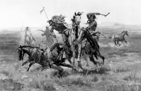
Note: the The Canadian Field-Naturalist is about a year and a half behind in actual publication, so although the journal issue in which this paper appeared is dated Jan.-March 2007, the publication was available only earlier this week. Full text with cover is [here]. The cover of the issue features the C.M. Russell painting entitled “When Blackfeet and Sioux Meet.”
Selected excerpts:
Abstract: It has long been claimed that native people were conservationists who had little or no impact on wildlife populations. More recently, though, it has been suggested that native people were keystone predators, who lacked any effective conservation strategies and instead routinely overexploited large mammal populations. To test these hypotheses, I performed a continuous time analysis of wildlife observations made by Lewis and Clark because their journals are often cited as an example of how western North America teemed with wildlife before that area was despoiled by advancing European civilization. This included Bison, Elk, Mule Deer, Whitetailed Deer, Blacktailed Deer, Moose, Pronghorn Antelope, Bighorn Sheep, Grizzly Bears, Black Bears, and Grey Wolves. I also recorded all occasions on which Lewis and Clark met native peoples. Those data show a strong inverse relationship between native people and wildlife. The only places Lewis and Clark reported an abundance of game were in aboriginal buffer zones between tribes at war, but even there, wildlife populations were predator, not food-limited. Bison, Grizzly Bears, Bighorn Sheep, Mule Deer, and Grey Wolves were seldom seen except in aboriginal buffer zones. Moose were most susceptible to aboriginal hunting followed by Bison and then Elk, while Whitetailed Deer had a more effective escape strategy. If it had not been for aboriginal buffer zones, Lewis and Clark would have found little wildlife anywhere in the West. Moreover, prior to the 1780 smallpox and other earlier epidemics that decimated native populations in advance of European contact, there were more aboriginal people and even less wildlife. The patterns observed by Lewis and Clark are consistent with optimal foraging theory and other evolutionary ecology predictions.
Introduction
It has long been postulated that native people were conservationists who had little or no impact on wildlife populations (e.g.; Speck 1913, 1939a, 1939b). Studies of modern hunter-gatherers, however, have found little evidence that native people purposefully employ conservation strategies (Alvard 1993, 1994, 1995, 1998a, 1998b; Hill and Hurtado 1996), while archaeological data suggest that prehistoric people routinely overexploited large-mammal populations (Broughton 1994a, 1994b, 1997; Jones and Hilderbrant 1995; Janetski 1997; Butler 2000; Chatters 2004). Elsewhere, I have proposed that native people were keystone predators, who once structured entire ecosystems (Kay 1994, 1995, 1997a, 1997b, 1998, 2002).
To test these competing hypotheses, I performed a continuous-time analysis of wildlife observations made by Lewis and Clark on their expedition across North America in 1804-1806 because their journals are often cited as an example of how the West teemed with wildlife before that area was despoiled by advancing European civilization (Botkin 1995, 2004; Patten 1998: 70; Wilkinson and Rauber 2002; Nie 2003: 1). Lewis and Clark were the first Europeans to traverse what eventually became the western United States, and many of the native peoples they met had never before encountered Europeans. In addition, historians universally agree that Lewis and Clark’s journals are not only among the earliest, but also the most detailed and accurate, especially regarding natural history observations (Burroughs 1961; Ronda 1984; Botkin 1995, 2004). Thus, the descriptions left by Lewis and Clark are thought by many to represent the “pristine” state of western ecosystems (Craighead 1998: 597; Patten 1998: 70; Wilkinson and Rauber 2002; Botkin 2004). Botkin (1995: 1), for instance, described Lewis and Clark’s journey as “the greatest wilderness trip ever recorded.” …
The Long Tom and Chalker Sites
O’Neill, Brian L. , Thomas J. Connolly, and Dorothy E. Freidel, with contributions by Patricia F. McDowell and Guy L. Prouty. A Holocene Geoarchaeological Record for the Upper Willamette Valley, Oregon: The Long Tom and Chalker Sites. University of Oregon Anthropological Papers 61, Published by the Museum of Natural History and the Department of Anthropology, University of Oregon, Eugene. 2004.
Abstract:
Data recovery investigations at two prehistoric sites were prompted by the Oregon Department of Transportation’s realignment of the Noti-Veneta segment of the Florence to Eugene Highway (OR 126) in Lane County, Oregon. The Long Tom (35LA439) and Chalker (35LA420) archaeological sites are located on the floodplain of the Long Tom River in the upper Willamette Valley of western Oregon. Investigations at these sites included an examination of the geomorphic setting of the project to understand the processes that have shaped the landscape and to which its human occupants adapted. The cultural components investigated ranged in age between about 10,000 and 500 years ago.
Geomorphic investigation of this portion of the Long Tom River valley documents a landform history spanning the last 11,000 years. This history is punctuated by periods of erosion and deposition, processes that relate to both the preservation and absence of archaeological evidence from particular periods. The identification of five stratigraphic units, defined from trenching and soil coring in the project area, help correlate the cultural resources found at sites located in the project. Stratigraphic Unit V, found at depths to approximately 250 cm, is a clayey paleosol with cultural radiocarbon ages between 11,000 and 10,500 cal BP. Unit N, with radiocarbon ages between approximately 10,000 and 8500 cal BP, consists of fine-textured sediments laid down during a period of accelerated deposition. An erosional unconformity separates Unit IV from the overlying Unit III. In the archaeological record, this unconformity represents a gap of nearly 3000 years, from 8500 to 5700 cal BP, and corresponds to a period of downcutting in the Willamette system that culminated with a transition from the Winkle to Ingram floodplain surfaces. Unit III sediments are sandy loams within which are found numerous oven features at the Long Tom, Chalker, and other nearby archaeological sites, and date between approximately 5700 to 4100 years ago. A near absence of radiocarbon-dated sediments in the project area between approximately 4100 and 1300 years ago suggests either a lack of use of this area during this period, or an erosional period that was apparently less severe on a regional scale. Units II and I are discontinuous bodies of vertically accreted sediments which represent a period of rapid deposition in the project area during the last 1300 years. It is estimated that Unit I sediments were deposited within the last 500 years.
Investigations at the Long Tom site discovered three cultural components. Components 1 and 3 are ephemeral traces of human presence at the site. The Late Holocene-age Component 1, found within Stratigraphic Units I and II, contains a small assemblage of chipped stone tools and debitage dominated by locally obtainable obsidian. The Early Holocene-age Component 3 contains a single obsidian uniface collected from among a scatter of fire-cracked rock and charcoal found within Stratigraphic Unit IV. Charcoal from this feature returned a radiocarbon age of 9905 cal BP. Contained within Stratigraphic Unit III, Component 2 presents evidence for a concentrated period of site use between approximately 5000 and 4000 cal BP. Geophysical exploration of the deep alluvial sediments with a proton magnetometer located magnetic anomalies, a sample of which was mechanically bisected and hand-excavated for closer analysis. A total of 21 earth ovens and two rock clusters was exposed in sediments associated with radiocarbon ages clustering about 4400 cal BP. Charred fragments of camas bulbs and hazelnut and acorn husks were recovered from the ovens. Few tools were discovered in their vicinity. Larger-scale excavations within the Middle Holocene sediments at the west end of the site discovered what is interpreted as a residential locus.
The Standley Site
Connolly, Thomas J., with contributions by Joanne M. Mack, Richard E. Hughes, Thomas M. Origer, and Guy L. Prouty. The Standley Site (35D0182): Investigations into the Prehistory of Camas Valley, Southwest Oregon. University of Oregon Anthropological Papers No. 43. Published by the Department of Anthropology and Oregon State Museum of Anthropology University of Oregon, Eugene, October 1991.
Abstract:
The Standley site (35D0182) is located at the southern edge of Camas Valley, a small basin on the upper Coquille River of southwestern Oregon. The earliest radiocarbon date from the site is 2350 ± 80 years ago, but obsidian hydration analysis suggests that initial occupation may have begun between 4500 and 5000 years ago. Both obsidian hydration and radiocarbon evidence suggest that occupation was most intense and continuous between 3000 and 300 years ago.
Cultural patterns at the Standley site are unclear at both ends of this occupation span; the remains of the earliest use episodes were disturbed by later prehistoric occupations, and the upper levels of the site were severely disturbed by historic activity. Radiocarbon evidence for the latest occupation period (within the last 500 years) includes dates from the basal portions of posts preserved in the lower levels of the site. The best preserved cultural patterns at the site, presumed to be associated with a set of radiocarbon dates ranging from 1180 to 980 years ago, are within a relatively rock-free area in the north-central portion of the main excavation block. Distinct artifact clusters, and possible structural remains, are present within this area.
The large size of the Standley site, the possible presence of structures, and the variety and density of artifact types present-including an enormous array of chipped stone tools, hammers and anvils, edge-ground cobbles, abrading stones, pestles, stone bowls, clay figurines, painted tablets, and exotic material such as schist, pumice, and steatite-indicate that the site served as a substantial encampment of some duration. There was some evidence for structural remains (posts and bark), but no clear evidence for semisubterranean housepits such as those reported elsewhere in southwest Oregon. The presence of charred hazelnuts and camas bulbs suggest a probable summer-to-fall occupation.
Life Among the Piutes: Their Wrongs and Claims
Winnemucca, Sarah (Thocmentony). Life Among the Piutes: Their Wrongs and Claims. Self-published, 1883. Edited by Mary Peabody Mann.
Full text [here]
Sarah Winnemucca (Thocmentony, or Shell Flower, was her Indian name) learned English and Spanish, how to read and write, and became a teacher. She started her own reservation schools, represented the Winnemucca Tribe in Washington, D.C., gave over 300 lectures on behalf of her people, and wrote her autobiography, Life Among the Piutes. It was the first book written in English by a Native American woman. She accomplished all this in an era when women of any color didn’t even have the right to vote.
Sarah Winnemucca was born in 1844. She died after a most eventful life October 16, 1891 at her sister’s home near Henry’s Lake, Idaho.
In 2005 she was honored with a statue in the U.S Capitol, nominated by the State of Nevada.
Some excerpts from Life Among the Piutes, Sarah Winnemucca’s autobiography:
I was born somewhere near 1844, but am not sure of the precise time. I was a very small child when the first white people came into our country. They came like a lion, yes, like a roaring lion, and have continued so ever since, and I have never forgotten their first coming. My people were scattered at that time over nearly all the territory now known as Nevada. My grandfather was chief of the entire Piute nation, and was camped near Humboldt Lake, with a small portion of his tribe, when a party travelling eastward from California was seen coming. When the news was brought to my grandfather, he asked what they looked like? When told that they had hair on their faces, and were white, he jumped up and clasped his hands together and cried aloud–”My white brothers–my long-looked for white brothers have come at last!”…
He had expected so much pleasure in welcoming his white brothers to the best in the land, that after looking at them sorrowfully for a little while, he came away quite unhappy. But he would not give them up so easily. He took some of his most trustworthy men and followed them day after day, camping near them at night, and travelling in sight of them by day, hoping in this way to gain their confidence. But he was disappointed, poor dear old soul!
I can imagine his feelings, for I have drank deeply from the same cup. When I think of my past life, and the bitter trials I have endured, I can scarcely believe I live, and yet I do; and, with the help of Him who notes the sparrow’s fall, I mean to fight for my down-trodden race while life lasts…