Nataraja: India’s Cycle of Fire
Stephen J. Pyne. 1994. Nataraja: India’s Cycle of Fire. Environmental History Review, Vol. 18, No. 3 (Autumn, 1994), pp. 1-20.
Full text [here]
Selected excerpts:
In the center dances Shiva, a drum in one hand and a torch in the other, while all around flames inscribe an endless cycle of fire.
This-the nataraja, the Lord of the Dance-is more than one of Hinduism’s favored icons. It is a near-perfect symbol of Indian fire history. The drum represents the rhythm of life; the torch, death; the wheel of flame, the mandala of birth, death, and rebirth that fire epitomizes and makes possible. In this confrontation of opposites the dance replaces the dialectic; Shiva holds, not reconciles, both drum and torch. Considered ecologically the nataraja thus expresses in graphic language the great polarity of India, the annual alternation of wet and dry seasons by which the monsoon, with faint transition, imposes its opposing principles on the subcontinent.
India’s biota, like Shiva, dances to their peculiar rhythm while fire turns the timeless wheel of the world. Perhaps nowhere else have the natural and the cultural parameters of fire converged so closely and so clearly. Human society and Indian biota resemble one other with uncanny fidelity. They share common origins, display a similar syncretism, organize themselves along related principles. Such has been their interaction over millennia that the geography of one reveals the geography of the other. The mosaic of peoples is interdependent with the mosaic of landscapes, not only as a reflection of those lands but as an active shaper of them (emphasis added). Indian geography is thus an expression of Indian history, but that history has a distinctive character, of which the nataraja is synecdoche, a timeless cycle that begins and ends with fire.
The cycle originated with the passage of India as a fragment of Gondwana into a violent merger with Eurasia. The journey northward, through the fiery tropics; the violence of the great Deccan basalt flows and of the immense collision with Asia; the installment of seasonality in the form of the monsoon-all this purged the subcontinent of much of its Gondwana biota, and tempered the rest to drought and fire. The populating of India came instead by influx from outside lands, followed by varying degrees of assimilation. Here, in the choreography of the nataraja, east met west, Eurasia confronted Gondwana, wet paired with dry, life danced with death.
What endemics remained were, like India’s tribal peoples, scattered or crowded into hilly enclaves. Only 6.5% of India’s flowering plants are endemic, compared with 85% in Madagascar and 60% in Australia. The residual biota thrived most fully to the south; Peninsular India holds a third of the subcontinent’s endemic flora. Some species, Asian in character, entered from the northeast. A diffuse array emigrated from the eastern Mediterranean, the steppes, and even Siberia, the Himalayas serving less as a barrier than a corridor. More recently weeds, largely European, have established themselves. The composition of its biota thus recapitulates the composition of its human population-the tribal peoples, their origins obscured; the Dravidians who persevered on the Deccan plateau and to the south; the Southeast Asians, migrating through Assam and Bengal; the Aryans, Huns, Turks, Persians, Pathans, Mongols, and others, entering from the northwest; and Arabs and Europeans, mostly Portuguese and British, arriving by sea.
The geographic ensemble that emerged from this vast convergence was both familiar and unique. Of course there were broad divisions, Asians here, Dravidians here. Of course there were mosaics of field, grassland, and forest, in part because of human influence. But even beyond such matters, this syncretic biota assumed the character of something like a caste society. It is probable that this was no accident. The organization of Indian society impressed itself on the land, with ever greater force and intricacy. Tribal people gathered into disease-ridden hills, better shielded genetically from malaria and other ills. They then reworked those hills in ways that conferred on them a biotic identity. It is no accident that the species most commonly found in habited areas are those most abundantly exploited by the human inhabitants, and are often those best adapted to fire. European weeds, like forts and factories, gathered into specially disturbed sites, then spread along corridors of travel or secondary disturbance. The intricate division of Indian society by caste ensured that different peoples did particular things at particular times, and this was reflected in the landscape of India, not only between regions but within areas that different groups exploited at different times in different ways for different purposes.
The intensity of the monsoon assured-demanded-a place for fire. The sharper the gradient, the more vigorous the potential for burning. Some of the wettest places on Earth, like the Shillong Hills, could paradoxically experience fire and even fire-degraded landscapes. The biota, already adapted to rough handling by India’s passage north, responded to fire readily. The flora and fauna that humans introduced, or that migrated into India coincidental with them, also had to be fire-hardened because humans added to and often dominated the spectrum of environmental disturbances and they certainly exploited fire. Explorers and ethnographers reported the practice among southern tribal groups (and in the Andaman Islands) of habitually carrying firesticks, a practice relatively rare outside of Australia and a few other regions. Probably Radcliffe-Brown’s peroration on fire and the Andaman Islanders could stand for most tribal peoples on the subcontinent. Fire, he concluded,
… may be said to be the one object on which the society most of all depends for its well-being. It provides warmth on cold nights; it is the means whereby they prepare their food, for they eat nothing raw save a few fruits; it is a possession that has to be constantly guarded, for they have no means of producing it, and must therefore take care to keep it always alight; it is the first thing they think of carrying with them when they go on a journey by land or sea; it is the centre around which the social life moves, the family hearth being the centre of the family life, while the communal cooking place is the centre round which the men often gather after the day’s hunting is over. To the mind of the Andaman Islander, therefor, the social life of which his own life is a fragment, the social well-being which is the source of his own happiness, depend upon the possession of fire, without which the society could not exist. In this way it comes about that his dependence on the society appears in his consciousness as a sense of dependence upon fire and a belief that it possesses power to protect him from dangers of all kinds.
The belief in the protective power of fire is very strong. A man would never move even a few yards out of camp at night without a firestick. More than any other object fire is believed to keep away the spirits that cause disease and death. …
Pre-Columbian agricultural landscapes, ecosystem engineers, and self-organized patchiness in Amazonia
Doyle McKey, Stephen Rostain, Jose Iriarte, Bruno Glaser, Jago Jonathan Birk, Irene Holst, Delphine Renard. 2010. Pre-Columbian agricultural landscapes, ecosystem engineers, and self-organized patchiness in Amazonia. Proc Natl Acad Sci USA. 107(17):7823-8.
Full text [here]
Abstract
The scale and nature of pre-Columbian human impacts in Amazonia are currently hotly debated. Whereas pre-Columbian people dramatically changed the distribution and abundance of species and habitats in some parts of Amazonia, their impact in other parts is less clear. Pioneer research asked whether their effects reached even further, changing how ecosystems function, but few in-depth studies have examined mechanisms underpinning the resilience of these modifications.
Combining archeology, archeobotany, paleoecology, soil science, ecology, and aerial imagery, we show that pre-Columbian farmers of the Guianas coast constructed large raised-field complexes, growing on them crops including maize, manioc, and squash. Farmers created physical and biogeochemical heterogeneity in flat, marshy environments by constructing raised fields. When these fields were later abandoned, the mosaic of well-drained islands in the flooded matrix set in motion self-organizing processes driven by ecosystem engineers (ants, termites, earthworms, and woody plants) that occur preferentially on abandoned raised fields.
Today, feedbacks generated by these ecosystem engineers maintain the human-initiated concentration of resources in these structures. Engineer organisms transport materials to abandoned raised fields and modify the structure and composition of their soils, reducing erodibility. The profound alteration of ecosystem functioning in these landscapes coconstructed by humans and nature has important implications for understanding Amazonian history and biodiversity. Furthermore, these landscapes show how sustainability of food-production systems can be enhanced by engineering into them fallows that maintain ecosystem services and biodiversity. Like anthropogenic dark earths in forested Amazonia, these self-organizing ecosystems illustrate the ecological complexity of the legacy of pre-Columbian land use.
Cultivated Landscapes Cultural Landscapes Fire History Native Cultures The Wilderness Myth
by admin
Comments Off
Before Columbus: The Americas of 1491
Charles C. Mann and Rebecca Stefoff. 2009. Before Columbus: The Americas of 1491. Atheneum Books for Young Readers, Simon & Schuster.
Available [here]
This book should be in every school.
The study of historical human influences on the environment is hampered by stubborn adherence to myths and falsehoods developed in childhood. Schools teach that Native Americans were few, savage, and insignificant wandering nomads who lived in a wilderness before Europeans arrived to tame the Americas.
Charles C. Mann’s 2005 bestseller, 1491: New Revelations of the Americas Before Columbus [here], exploded many of those myths. He essayed the new, developing ideas and evidence regarding pre-Columbian America indicating that the Western Hemisphere was populated by millions of people living in civilizations older and more advanced than those of the invading Europeans.
Now Mann and co-author Rebecca Stefoff have adapted 1491 into a book for school children. Before Columbus: The Americas of 1491 is a gorgeous “coffee table” book filled with vibrant pictures and a text that is exciting and understandable for younger scholars.
Teachers and parents take note. Don’t let your kids grow up to be ignorant of their roots. The landscapes we live in have been cultural landscapes, shaped by humanity, for thousands of years. The heritage of place is your heritage and that of your children.
Part One of Before Columbus: The Americas of 1491 examines the question “How Old was the New World?” Archaeologists keep pushing the date back, but without a doubt human beings were living throughout the Americas 10,000 years ago (8,000 BC). The first cities may have been along the Peruvian coast. The pyramids at Huaricanga are at least 5,500 years old. The residents also built irrigation canals to water cotton fields, from which they made nets to harvest fish. Ancient mariners sailed far out into the Pacific to net anchovies, sardines, and other fish. Their cultural stamp (the distinctive gods carved on gourds) can be seen in rock carvings and temples crafted thousands of years later at Lake Titicaca, the cradle of Incan civilization.
Part Two asks “Why Did Europe Succeed?” and includes four chapters on “The Great Meeting” (Cortez and the Aztecs at Tenochtitlan), “Long, Long Ago” (the first Americans, the PaleoIndians, and Monte Verde in Chile), “Extinction” (the demise of the megafauna, including mammoths), and “Disease-Free Paradise? (the impact of European disease on the Native Americans).”
Part Three examines “Were the Americas really a Wilderness?” It’s chapters include “Amazonia” with discussion of the fruit and nut orchards found across the Amazon Basin and the anthropogenic soils called terra preta. “Land of Fire” discusses the way in which Indians maintained a living anthropogenic mosaic of prairies, savannas, and open, park-like forests, principally through the use of controlled burning. In “The Created Wilderness” the authors explain how those human-shaped landscapes were abandoned when the Indian populations nearly disappeared following the introduction of Old World diseases.
We cannot plan for the future if we do not understand the past. Forests cannot be cared for, and the desired future conditions cannot be achieved, if we do not have a firm grasp on how our forests developed in the first place.
Mann and Stefoff seek to instruct our youth with the truth, so that as adults they can make informed judgments about environmental stewardship.
Buy this book. Better yet, buy a dozen copies and donate them to your local schools. Raise the consciousness about the distant past so that our coming future is guided by knowledge instead of myth.
The History of Fire in the Southern United States
Cynthia Fowler, Evelyn Konopik. 2007. The History of Fire in the Southern United States. Human Ecology Review, Vol. 14, No. 2, 2007
Full text [here]
Selected excerpts:
Abstract
Anthropogenic fires have been a key form of disturbance in southern ecosystems for more than 10,000 years. Archaeological and ethnohistorical information reveal general patterns in fire use during the five major cultural periods in the South; these are Native American prehistory, early European settlement, industrialization, fire suppression, and fire management. Major shifts in cultural traditions are linked to significant transitions in fire regimes. A holistic approach to fire ecology is necessary for illuminating the multiple, complex links between the cultural history of the South and the evolution of southern ecosystems. The web of connections between history, society, politics, economy, and ecology are inherent to the phenomena of fire.
A Holistic View of People and Fire
Written documents that address fire ecology in the South include more than 380 years of publications, ranging from Smith’s 1625 monograph to Kennard’s 2005 essay. This body of literature includes the travelogues of European explorers, research reports on fossil pollen and charcoal records, as well as critical analyses of fire management policies. The wide variety of perspectives that is represented in
this literature reflects the web of connections between history, society, politics, economy, and ecology that are inherent to the phenomena of fire.
A multidisciplinary synthesis of the literature in light of the complexity of fire ecology will lead us to a better understanding of long term interactions between people and fire in specific ecological communities. In this article, we approach the fire ecology literature from two points of view, looking at “fire through people’s eyes” and “people through fire’s eyes” (Vayda 2005). We describe general patterns in fire use during five major cultural periods (Table 1) in four of the South’s physiographic regions: the Coastal Plains, Piedmont, Southern Appalachians, and Ozark-Ouachita Highlands. Using this holistic framework, we consider “both ends of the fire stick” (Vayda 2005) examining elements of fire use by each cultural group that has inhabited the South and its effects on southern ecosystems.
Pre-Columbian geometric earthworks in the upper Pur’us: a complex society in western Amazonia
Martti Parssinen, Denise Schaan, and Alceu Ranzi. 2009. Pre-Columbian geometric earthworks in the upper Pur’us: a complex society in western Amazonia. Antiquity 83 (2009): 1084–1095
Full text [here]
Selected excerpts:
Abstract
It’s an ill wind that blows nobody any good. The combination of land cleared of its rainforest for grazing and satellite survey have revealed a sophisticated pre-Columbian monument-building society in the upper Amazon Basin on the east side of the Andes. This hitherto unknown people constructed earthworks of precise geometric plan connected by straight orthogonal roads. Introducing us to this new civilisation, the authors show that the ‘geoglyph culture’ stretches over a region more than 250km across, and exploits both the floodplains and the uplands. They also suggest that we have so far seen no more than a tenth of it.
Introduction
According to mid-twentieth-century neo-evolutionist interpretations of cultural development in the South American lowlands, pre-European Amazonian societies were mainly considered to be primitive egalitarian tribes living in small, impermanent villages in a hostile environment, unable to develop complex socio-political institutions (Steward 1948; Meggers 1954). Although historical accounts mentioned that floodplain river banks and islands were heavily populated by chiefdoms with village leaders and superior lords, some students of Amazonian archaeology and ethnology emphasised important differences between floodplain (varzea) and upland (terra firme) ecosystems. According to Lathrap’s model, for example, the varzea constantly attracted peoples due to its bountiful resources, especially aquatic fauna and good alluvial soils; but, as population pressure over limited land took its toll, they were forced to flee to the hinterland terra firme, where their cultural level decreased (Lathrap 1968, 1970). In her own way, Meggers (1991, 1995) also acknowledged higher levels of cultural complexity for varzea peoples, where some level of social hierarchy and elaborate material culture could develop, thanks to better soils. In her account, terra firme peoples remained demographically smaller and less complex, and were forced to live as hunters, collectors and semi-sedentary slash-and-burn cultivators. …
Roosevelt (1980), for her part, also had an important role in defending the varzea/terra firme dichotomy, emphasising the fact that the alluvial soils of the varzea were critical for supporting the indigenous development of chiefdoms, an idea not backed up by neo-evolutionist determinism, which always gave priority to outside cultural developments. …
As we can see, although scholars had different ideas on how to account for the differences between the two main Amazonian environments, the basic dichotomy between varzea (floodplain) and terra firme (interfluvial hinterland) remained valid for some time. In fact, given the scarcity of archaeological data for hinterland areas, researchers concentrated their efforts in trying to figure out how social complexity arose among floodplain societies (Carneiro 1970, 1987; Roosevelt 1993), accepting, even if not explicitly, that terra firme peoples had remained smaller and simpler.
World Trade and Biological Exchanges Before 1492
John L. Sorenson, Carl L. Johannessen. 2009. World Trade and Biological Exchanges Before 1492. iUniverse. ISBN: 978-0-595-52441-9
A book review by Mike Dubrasich
There exists a pernicious myth that American Indians were savages (noble or not) living in roving bands of hunter-gatherers, at one with Nature due to their lack of civilization and technological sophistication.
That myth has been exploded by cutting-edge anthropology, archaeology, and historical landscape geography.
Prior to Columbus’ “discovery” of the “New World”, human beings had lived and thrived in the Americas for 12,000 years or more. They built great cities such as Teotihuacan, which by 700 C.E. had an estimated population of 200,000 and was larger than Paris and London combined four hundred years later!
Pre-Columbian Americans developed writing, mathematics, astronomy, and agriculture. Cropping systems were in use as much as 9,000 years ago [here] and had spread across much of both North and South America by 5,800 years ago [here].
People built incredible earthworks including terraces, raised fields, canals and irrigation systems for agriculture [here]. People modified soils for food cropping across vast territories such as Amazonia [here].
And pre-Columbian people developed food crops such corn (maize), potatoes, tomatoes, peanuts, pumpkins (all edible squashes), sweet potatoes, sunflowers, peppers, pineapples, watermelons, strawberries, and pecans. All edible beans except horse beans and soybeans were developed in the pre-Columbian Americas.
It is widely believed that these food crops, common around the world today, were not known outside the Americas until Columbus and other contemporary explorers brought them to Europe 500 years ago. But if so, how do you explain this?

This wall sculpture from the Hoysala Dynasty Halebid temple at Somnathpur, Karnataka state, India, dates between the eleventh and thirteenth centuries. Among the numerous representations of maize ears, the shape of the ear, kernels off set in relation to those in adjacent rows, the presence of part of the husk, and other features ensure that no object other than an ear of maize could be represented. The mudra (sacred gesture) made by the figure’s hand underlines the sacred significance of the context and thus of maize. (Photograph by C. Johannessen.)
In World Trade and Biological Exchanges Before 1492 authors John L. Sorenson and Carl L. Johannessen present strong evidence that pre-Columbian Americans engaged in overseas trade:
People moved into America very early across the Bering Strait. By the fifth millennia B.C.E. tropical sailors brought diseases to America and took plants and animals in both directions.
Long before Columbus, tropical sailors carefully selected crops from New World highlands and shorelines, wet and dry climates, and took them to the Old World where they were grown in appropriate environments. Medicinal and psychedelic plants were traded and maintained in Egypt and Peru during separate 1,400-year periods. This implies that maritime trade was continuous.
In this groundbreaking book, learn about:
* 84 plants that were taken from the Americas to the Old World.
* What plants and animals were brought to the Americas.
* Why world trade was essential for transfer of so many.
* Interconnectedness of civilizations had to result from world trade.
* Dating of 18 species by archaeology with radio carbon shows dispersal.
* And much more!Plants, diseases, and animals from America were distributed throughout the world, across the oceans before 1492. It is time for scientists, teachers, and students to reconsider their beliefs about the early history of civilization with World Trade and Biological Exchanges Before 1492.
Initial formation of an indigenous crop complex in eastern North America at 3800 B.P.
Bruce D. Smith and Richard A. Yarnell. 2009. Initial formation of an indigenous crop complex in eastern North America at 3800 B.P. Proceedings of the National Academy of Sciences, Vol. 106 No. 16 pp 6561–6566.
Full text [here]
Selected excerpts [here]
Abstract
Although geneticists and archaeologists continue to make progress world-wide in documenting the time and place of the initial domestication of a growing number of plants and animals, far less is known regarding the critically important context of coalescence of various species into distinctive sets or complexes of domesticates in each of the world’s 10 or more independent centers of agricultural origin. In this article, the initial emergence of a crop complex is described for one of the best-documented of these independent centers, eastern North America (ENA). Before 4000 B.P. there is no indication of a crop complex in ENA, only isolated evidence for single indigenous domesticate species. By 3800 B.P., however, at least 5 domesticated seed-bearing plants formed a coherent complex in the river valley corridors of ENA. Accelerator mass spectrometer radiocarbon dates and reanalysis of archaeobotanical assemblages from a short occupation of the Riverton Site in Illinois documents the contemporary cultivation at 3800 B.P. of domesticated bottle gourd (Lagenaria siceraria), marshelder (Iva annua var. macrocarpa), sunflower (Helianthus annuus var. macrocarpus), and 2 cultivated varieties of chenopod (Chenopodium berlandieri), as well as the possible cultivation of Cucurbita pepo squash and little barley (Hordeum pusillum). Rather than marking either an abrupt developmental break or a necessary response to population-packing or compressed resource catchments, the coalescence of an initial crop complex in ENA appears to reflect an integrated expansion and enhancement of preexisting hunting and gathering economies that took place within a context of stable long-term adaptation to resource-rich river valley settings.
Introduction
Marking a major evolutionary episode in human history, the transition from hunting and gathering to agricultural economies spanned several millennia and occurred independently in 10 or more different world regions, including eastern North America (ENA) (1) (Fig. 1). In each of these independent centers, this long transition began with the initial domestication of a number of indigenous wild progenitor species. These different domesticates eventually were coalesced to form regionally distinctive complexes of domesticates and low-level food production economies. As a result of parallel and often cross-illuminating efforts by geneticists and archaeologists over the past several decades, we are gaining a much clearer idea of where and when domestication of different individual species of plants and animals occurred (3, 4). Much less is currently known, however, about the equally important process that led to numbers of different species being brought together to form coherent distinctive domesticate complexes in different world regions. When did such domesticate complexes initially develop? What was the identity and relative importance of each complex’s different constituent species? What can be said regarding the environmental and cultural context of coalescence of these early domesticate complexes in different world regions, and what can be said about the societies that developed them? Combining extant information with new data, this article addresses these key questions and provides a clear picture of the initial emergence of a crop complex in one of the world’s best-documented independent centers of domestication — the eastern woodlands of North America.
The Temporal and Spatial Context of Initial Plant Domestication in ENA
Based on several morphological changes associated with the adaptive syndrome of domestication that have been documented in seed specimens recovered from 4 Late Archaic period archaeological sites in the Oak-Savannah and Oak-Hickory forest regions of ENA (i.e., seed size increase and reduction in seed-coat thickness), at least 4 indigenous seed-bearing plants were brought under domestication in the region over a span of ~1,200 years from 5000 to 3800 B.P. These plants include squash (Cucurbita pepo ssp. ovifera), sunflower (Helianthus annuus var. macrocarpus), marshelder (Iva annua var. macrocarpa), and chenopod (Chenopodium berlandieri) (1). Maize (Zea mays), the first Mesoamerican domesticate to reach ENA, did not arrive for another 1,500 years, at ~200 B.C. (see SI Text). In addition to these 4 species that exhibit morphological changes because of domestication, 3 other eastern seed plants that lack such changes have also been identified, based on their abundance in seed assemblages before 2000 B.P., as likely crops and as the subjects of deliberate planting and harvesting of stored seed stock. These plants include erect knotweed (Polygonum erectum), little barley (Hordeum pusillum), and maygrass (Phalaris caroliniana). …
An Asian origin for a 10,000-year-old domesticated plant in the Americas
David L. Erickson, Bruce D. Smith, Andrew C. Clarke, Daniel H. Sandweiss, and Noreen Tuross. 2005. An Asian origin for a 10,000-year-old domesticated plant in the Americas. Proceedings of the National Academy of Sciences, Vol. 102, No. 51.
Full text [here]
Selected excerpts:
Abstract
New genetic and archaeological approaches have substantially improved our understanding of the transition to agriculture, a major turning point in human history that began 10,000–5,000 years ago with the independent domestication of plants and animals in eight world regions. In the Americas, however, understanding the initial domestication of New World species has long been complicated by the early presence of an African enigma, the bottle gourd (Lagenaria siceraria). Indigenous to Africa, it reached East Asia by 9,000–8,000 before present (B.P.) and had a broad New World distribution by 8,000 B.P. Here we integrate genetic and archaeological approaches to address a set of long-standing core questions regarding the introduction of the bottle gourd into the Americas. Did it reach the New World directly from Africa or through Asia? Was it transported by humans or ocean currents? Was it wild or domesticated upon arrival? Fruit rind thickness values and accelerator mass spectrometer radiocarbon dating of archaeological specimens indicate that the bottle gourd was present in the Americas as a domesticated plant by 10,000 B.P., placing it among the earliest domesticates in the New World. Ancient DNA sequence analysis of archaeological bottle gourd specimens and comparison with modern Asian and African landraces identify Asia as the source of its introduction. We suggest that the bottle gourd and the dog, two “utility” species, were domesticated long before any food crops or livestock species, and that both were brought to the Americas by Paleoindian populations as they colonized the New World.
Introduction
Innovative approaches in genetics and archaeology continue to provide substantial new information regarding the origins of agriculture and the independent domestication of different species of plants and animals between 10,000 and 5,000 years ago in at least eight separate regions of the world (1–4). Not surprisingly, as they come into clearer focus, the developmental histories of each of these independent centers of domestication are turning out to be far more complex and nuanced than previously thought. Here we consider one of these imbedded complexities, the consistent occurrence of the bottle gourd (Lagenaria siceraria), an Old World plant, in close association with the earliest indigenous New World domesticates. In the process of answering basic questions regarding the early presence of this African plant in the Americas, we reach a number of unexpected conclusions regarding the cultural, environmental, and temporal contexts of initial human domestication of plants and animals.
The bottle gourd has been grown worldwide for thousands of years, usually not as a food source, but for the value of its strong, hard-shelled, and buoyant fruits, which have long been prized as containers, musical instruments, and fishing floats (5). This lightweight “container crop” would have been of particular importance to human societies before the advent of pottery and settled village life. Along with the five wild perennial species that also belong to the genus Lagenaria, the bottle gourd has long been recognized as being indigenous to Africa (5, 6). …
Cultivated Landscapes Cultural Landscapes Fire History Native Cultures
by admin
leave a comment
Evaluating the Purpose, Extent, and Ecological Restoration Applications of Indigenous Burning Practices in Southwestern Washington
Linda Storm and Daniela Shebitz. 2006. Evaluating the Purpose, Extent, and Ecological Restoration Applications of Indigenous Burning Practices in Southwestern Washington. Ecological Restoration, Vol. 24, No. 4, 2006.
Selected excerpts:
Abstract
Understanding the historic fire regime is essential before restoring fire to an ecosystem. Historical ecology provides a means to use both quantitative and qualitative data from different disciplines to address questions about how the traditional ecological management (TEM) practices of indigenous peoples influenced prairie and savanna ecosystems in the past. In this article, we evaluated paleoecological, archaeological, ethnographic, and ethnobotanical information about the Upper Chehalis River basin prairies of southwestern Washington to better understand the extent to which TEM influenced prairie distribution, composition, and availability of wild plant food resources. We also surveyed areas that had been burned at differing frequencies to test whether frequent fires increase camas (Camassia quamash) productivity. Preliminary results support the hypothesis that camas productivity increases with fire-return intervals of one to two years.
Introduction
A number of anthropologists, ethnobotanists, and ecologists now believe that indigenous peoples contributed to the long-term maintenance and distribution of prairie and savanna ecosystems in pre-European western Washington through traditional management techniques, such as burning (Norton 1979a, 1979b; Kruckeberg 1991; Agee 1993; Dunn and Ewing 1997; Boyd 1999a; Leopold and Boyd 1999; Wray and Anderson 2003). Following the decline of indigenous cultures and the subsequent absence of low-intensity, high-frequency fires, areas in western Washington that were once prairies and savannas have naturally succeeded to conifer-dominated forests (Lang 1961).
Today, there are efforts underway to restore the fire-dependent prairies and savannas of western Washington and the many now rare, threatened, and endangered species that continue to exist in those degraded ecosystems (Dunn and Ewing 1997, Chappell and others 2001, Peter and Shebitz 2006).
In this paper, we use a historical ecology methodology to evaluate both the reasons why indigenous peoples in the Upper Chehalis River basin managed prairie and savanna ecosystems and the extent of those practices through time and space. …
Cultivated Landscapes Cultural Landscapes Fire History Native Cultures The Wilderness Myth
by admin
Comments Off
Amazonian Dark Earths: Wim Sombroek’s Vision
William I. Woods (Editor), Wenceslau G. Teixeira (Editor), Johannes Lehmann (Editor), Christoph Steiner (Editor), Antoinette M.G.A. WinklerPrins (Editor), Lilian Rebellato (Editor). 2009. Amazonian Dark Earths: Wim Sombroek’s Vision. Springer; 1st edition (December 1, 2008). 504 pages.
Amazon.com listing [here].
Review by Mike Dubrasich
A landmark book has been published on terra preta, Amazonian dark earths, the carbon-rich soils developed by ancient civilizations in what was once thought to be a pristine wilderness. Dedicated to Dutch soil scientist Wim Sombroek (1934-2003) who was the first modern investigator of terra preta, Amazonian Dark Earths: Wim Sombroek’s Vision is a compilation of the latest, cutting-edge studies in this fascinating and important multi-disciplinary field.
Amazonian soils are predominantly laterites [here], deeply weathered red clays lacking in most soil nutrients. Millions of years of rainfall have leached out everything but iron (hence the red color), silica, and aluminum. Essential plant nutrients such as calcium, phosphorus, and potassium are nearly missing. Amazon vegetation subsists on itself, the thin humus of decaying plant matter being the only source of key metallic oxides.
Except where there is terra preta, or it’s close cousin terra mulata. Terra preta is deep, rich, fertile, black soil that occurs in patches on bluffs along the Amazon and its tributaries. Terra preta is filled with charcoal, ash, mulch, bones, and pottery shards! It is potting soil made from organic matter transported to the sites in pots! These anomalous soils are anthropogenic: people made them.
[Dr. William] Denevan (2001:116–119) has argued that in pre-Columbian times the use of stone axes made long-fallow shifting cultivation very inefficient, and as result probably uncommon until the European introduction of metal axes. Previously, soil fertility must have been maintained and improved by frequent composting, mulching, and in-field burning, making semi-permanent cultivation possible with only brief fallowing. Over time these activities could have produced fertile, self-sustaining dark earths.
Dark earths may occupy 0.1% to 0.3%, or 6,000 to 18,000 km2, of forested lowland Amazonia (Sombroek and Carvalho 2002:130). Because their densities vary greatly within subregions and almost no systematic survey has been accomplished within Amazonia, variations in density projections of an order of magnitude are to be expected. The dark earths occur in a variety of climatic, geologic, and topographic situations, both along river bluffs and in the interior, with depths sometimes exceeding 2.0 m. Individual patches range from 1 ha or so to several hundred hectares. — from Chapter 1, Amazonian Dark Earths: The First Century of Reports by William I. Woods and William M. Denevan
Rather than a pristine, untrammeled, unoccupied wilderness, Amazonia has been home to people for thousands of years. The indigenous residents were agriculturalists who modified soils in order to grow corn (maize), squash, beans, fruiting palms, gourds, pineapples, cotton, arrowroot, and many other cultivated fruits, nuts, tubers, and fibers.
Terra mulata is brownish soil that generally surrounds patches of terra preta. It is not quite as rich and has fewer artifacts, and is even more widespread than terra preta. In theory, terra mulata is the accidentally improved soil adjacent to the deliberately improved soils, or else it is terra preta in the making. In either case, anthropogenically altered soils are in strong contrast to the unaltered laterites, and cover a combined area the size of France.
One of the key elements of terra preta is charcoal, lately termed “biochar”.
Vegetation actively withdraws carbon from the atmosphere and stores it as organic matter. Biochar is created when organic matter is heated without oxygen and it contains twice the carbon content of ordinary biomass (Lehmann 2007). Biochar is much more resistant to decay and can store carbon for centennial timescales (Lehmann et al. 2006). The addition of biochar to the soil was part of the creation of ADE [Amazon dark earths] (Neves et al. 2003). This has lead some to speculate on the viability of a biochar carbon sequestration industry which would reduce atmospheric greenhouse gases (Marris 2006; Sombroek et al. 2002) and improve soil fertility (Lehmann et al. 2003; Glaser and Woods 2004). — from Chapter 14, Locating Amazonian Dark Earths (ADE) Using Satellite Remote Sensing – A Possible Approach by J Thayn, KP Price, and WI Woods.
Biochar is touted as a “solution” to the global warming “problem.” I demure. But biochar is definitely a valuable soil amendment because carbon binds to and stores the metallic oxide nutrients essential to plant growth. The addition of charcoal as well as organic detritus helped to create and sustain terra preta over centuries.
Amazonian Dark Earths: Wim Sombroek’s Vision is a wonderful account of the history and science of anthropogenic soils. The book is as rich as terra preta in literary as well as scientific writing.
Cultivated Landscapes of Native Amazonia and the Andes
William M. Denevan. 2001. Cultivated Landscapes of Native Amazonia and the Andes. Oxford University Press, 2001.
Review by Mike Dubrasich
Cultivated Landscapes of Native Amazonia and the Andes is widely recognized as the modern masterpiece of historical landscape geography. It is one of a trilogy of books inspired and coordinated by William Denevan. The others are Cultivated Landscapes of Native North America by William Doolittle and Cultivated Landscapes of Middle America on the Eve of Conquest by Thomas M. Whitmore and B.L. Turner II.
The authors of all three volumes are landscape geographers who have studied the profound and lasting impacts that indigenous human beings have had over thousands of years on the vegetation, soils, hydrology, and wildlife of the Americas.
Denevan is the unofficial “godfather” of an intellectual tradition that developed under Carl O. Sauer in the Department of Geography at Berkeley. UCLA’s Susanna Hecht described that tradition (tongue in cheek, with affection) as a machine:
The geographer William Denevan’s “machine” (and its affines) and the Berkeley School of cultural geography converged with historical ethnobotany and compiled an extensive set of analyses on indigenous resource management systems in Central America, the Andes, and the Amazon, where questions about landscape and ecological histories whose logics, though not divorced from productionist questions (what fed large populations in these difficult montane or tropical environments?) were linked to their historical, agroecological and environmental underpinnings (Balée and Erickson 2006; Denevan 1970, 1976, 1992, 2001; Denevan and Padoch 1987; Erickson 2000; Whitmore and Turner 2001; Zimmerer 2001). It was this framework, as well as pro indigenous activism that gave impetus to other projects, such as Darrell Posey’s 12 year Kayapó project, and those spearheaded by New York Botanical Garden’s Gillian Prance. — from SB Hecht, Chapter 7, Kayapó Savanna Management: Fire, Soils, and Forest Islands in a Threatened Biome in William Woods et al. 2009. Amazonian Dark Earths: Wim Sombroek’s Vision, Springer (soon to be released).
All those mentioned by the verbose Hecht (Bill Woods, Bill Balée, Clark Erickson, etc.) and many more of our leading landscape geographers, anthropologists, ethnobotanists, and forest historians, trace their intellectual roots to Bill Denevan. Charles C. Mann’s fascinating bestseller, 1491: New Revelations of the Americas Before Columbus [here], was inspired directly and indirectly by Denevan and his “machine”.
In a biographical essay about Bill Denevan, I described him (tongue in cheek, with affection) as “the real Indiana Jones” [here]. As an adventurous young man in the 1950’s, Denevan boarded a freighter in Los Angeles and then jumped ship in Lima, Peru. He subsequently traversed South America and in a flight over eastern Bolivia “discovered” the signs of a lost civilization in the Llanos de Mojos. And like the fictitious Indiana Jones, Denevan went on to became a scholar (and Chair, now emeritus, of the Dept. of Geography at the University of Wisconsin-Madison).
Cultivated Landscapes of Native Amazonia and the Andes (and it’s companion books) is the culmination of a lifetime of pathfinding research and teaching. It is a text, organized and written for graduate and undergraduate instruction, but between the lines it is also a tale of adventure and exploration. The insights related in Cultivated Landscapes were gained by the combined efforts of dozens of field researchers braving jungles, savannas, trackless swamps, towering mountains, and seared deserts. The book is a synthesis, but it represents hands-on fieldwork in what we think of today as wilderness, but what in truth has been home to humanity for 10,000 years or more.
Ancient Earthmovers Of the Amazon
Charles C. Mann. 2008. Ancient Earthmovers Of the Amazon. Science, Vol 321, 29 August 2008, pp 1148-1152
Full text [here]
Much of the environmental movement is animated, consciously or not, by what geographer William Denevan calls “the pristine myth”—the belief that the Americas in 1491 were an almost untouched, even Edenic land, “untrammeled by man,” in the words of the Wilderness Act of 1964, a U.S. law that is one of the founding documents of the global environmental movement. - Charles C. Mann, 1491: New Revelations of the Americas Before Columbus.
The most “pristine” wilderness in the America’s is widely thought to be the Amazon. But in fact the Amazon has been home to humanity and human civilization for thousands of years. New anthropological and landscape geography research has turned up yet another “lost” civilization in the supposedly untrammeled Amazon, further proof that our landscapes hold ancient human tradition and use, the legacy impacts of which may still be seen today.
Wilderness is indeed a myth, a modern Euro-American construct that lacks veracity and validity in the real world. Before we impose more political myth on our landscapes, wouldn’t it be prudent and responsible to see and study them for what they are, ancient homelands and settings of human stewardship, not abandonment?
Selected excerpts:
The forested western Amazon was once thought barren of complex human culture. But researchers are now uncovering enigmatic earthworks left by large, organized societies that once lived and farmed here.
Alceu Ranzi was a geography student in 1977 when he helped discover half a dozen huge, prehistoric rings carved into the landscape in his home state of Acre in western Brazil. At the time, he was helping to conduct the first-ever full archaeological survey of Amazonia, which was being opened up for cattle ranches at a speed that was causing worldwide protests. The earthworks came to light on newly logged land.
The find attracted little attention. The Smithsonian-sponsored National Program of Archaeological Research in the Amazon Basin did not formally announce the rings for 11 years, and even then only in a little-read report. And Ranzi, who went on to become a respected paleontologist, most recently at the Federal University of Acre in Rio Branco, didn’t get back to studying the ditches until more than a decade after that. On a flight to Rio Branco in 1999, he spotted the earthworks again from the air and soon began looking for more. Within a year, he says, “we had found dozens more” of what he calls geoglyphs.
Shaped like circles, diamonds, hexagons, and interlocking rectangles, the geoglyphs are 100 to 350 meters in diameter and outlined by trenches 1 to 7 meters deep. Many are approached by broad earthen avenues, some of them 50 meters wide and up to a kilometer long. The geoglyphs “are as important as the Nazca lines,” Ranzi says, referring to the famed, mysterious figures outlined in stone on the Peruvian coast. …
For most of the last century, researchers believed that the western Amazon’s harsh conditions, poor soils, and relative lack of protein (in the form of land mammals) precluded the development of large, sophisticated societies. According to the conventional view, the small native groups that eked out a living in the region were concentrated around the seasonally flooded river valleys, which had better soil; the few exceptions were short-lived extensions of Andean societies. Meanwhile, the upland and headwaters areas-which include nearly all of western Amazonia-had been almost empty of
humankind and its works.Yet during the past 2 decades, archaeologists, geographers, soil scientists, geneticists, and ecologists have accumulated evidence that, as the geoglyphs team puts it, the western Amazon was inhabited “for hundreds of years” by “sizable, regionally organized populations”-in both the valleys and the uplands. The geoglyphs, the most recent and dramatic discovery, seem to extend across an area of about 1000 kilometers (km) from the Brazilian states of Acre and Rondônia in the north to the Bolivian departments of Pando and the Beni in the south (see map, p.1150). Much of this area is also covered by other, older forms of earthworks that seemingly date as far back as 2500 B.C.E.: raised fields, channel-like canals, tall settlement mounds, fish weirs, circular pools, and long, raised causeways (Science, 4 February 2000, p. 786), suggesting the presence of several cultures over a long period. And on page 1214 of this issue of Science, a U.S.-Brazilian team proposes that indigenous people in the south-central Amazon, 1400 km from Acre, lived in dense settlements in a form of early urbanism and created ditches and earthen walls that some say resemble the geoglyphs (see sidebar).
Cultivated Landscapes Cultural Landscapes The Wilderness Myth
by admin
Comments Off
The Pristine Myth: The Landscape of the Americas in 1492
William Denevan. 1992. The Pristine Myth: The Landscape of the Americas in 1492. Annals of the American Association of Geographers v. 82 n. 3 (Sept. 1992), pp. 369-385.
Full text [here]
Much of the environmental movement is animated, consciously or not, by what geographer William Denevan calls “the pristine myth”—the belief that the Americas in 1491 were an almost untouched, even Edenic land, “untrammeled by man,” in the words of the Wilderness Act of 1964, a U.S. law that is one of the founding documents of the global environmental movement. - Charles C. Mann, 1491: New Revelations of the Americas Before Columbus.
Selected excerpts:
Abstract. The myth persists that in 1492 the Americas were a sparsely populated wilderness, a world of barely perceptible human disturbance. There is substantial evidence, however, that the Native American landscape of the early sixteenth century was a humanized landscape almost everywhere. Populations were large. Forest composition had been modified, grasslands had been created, wildlife disrupted, and erosion was severe in places. Earthworks, roads, fields, and settlements were ubiquitous. With Indian depopulation in the wake of Old World disease, the environment recovered in many areas. A good argument can be made that the human presence was less visible in 1750 than it was in 1492.
What was the New World like at the time of Columbus? “Geography as it was,” in the words of Carl Sauer (1971). The Admiral himself spoke of a “Terrestrial Paradise,” beautiful and green and fertile, teeming with birds, with naked people living there whom he called “Indians.” But was the landscape encountered in the sixteenth century primarily pristine, virgin, a wilderness, nearly empty of people, or was it a humanized landscape, with the imprint of native Americans being dramatic and persistent? The former still seems to be the more common view, but the latter may be more accurate.
The pristine view is to a large extent an invention of nineteenth-century romanticist and primitivist writers such as W.H. Hudson, Cooper, Thoreau, Longfellow, and Parkman, and painters such as Catlin and Church. The wilderness image has since become part of the American heritage, associated “with a heroic pioneer past in need of preservation” (Pyne 1982, Bowden 1992). The pristine view was restated clearly in 1950 by John Bakeless in his book The Eyes of Discovery:
There were not really very many of these redmen … the land seemed empty to invaders who came from settled Europe . . . that ancient, primeval, undisturbed wilderness . . . the streams simply boiled with fish … so much game . . . that one hunter counted a thousand animals near a single salt lick … the virgin wilderness of Kentucky … the forested glory of primitive America (Bakeless 1950).
But then he mentions that Indian “prairie fires . . . cause the often-mentioned oak openings … Great fields of corn spread in all directions … the Barrens … without forest,” and that “Early Ohio settlers found that they could drive about through the forests with sleds and horses” (Ibid). A contradiction?
In the ensuing forty years, scholarship has shown that Indian populations in the Americas were substantial, that the forests had indeed been altered, that landscape change was commonplace. This message, however, seems not to have reached the public through texts, essays, or talks by both academics and popularizers who have a responsibility to know better. …
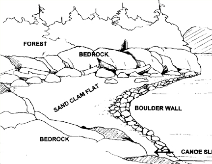
Clam Gardens
Williams, Judith. Clam Gardens: Aboriginal Mariculture On Canada’s West Coast. 2006. New Star Books LTD
Pre-Contact West Coast indigenous peoples are commonly categorized in anthropological literature as “hunter gatherers”. However, new evidence suggests they cultivated bivalves in stone-walled foreshore structures called “clam gardens” which were only accessible at the lowest of tides. Judith Williams journeyed by boat around Desolation Sound, Cortes and Quadra Islands and north to the Broughton Archipelago to document the existence of these clam gardens. The result is a fascinating book that bids to change the way we think about West Coast aboriginal culture. — from the back cover
Clam Gardens is a delightful little book, written by an artist and resident of the British Columbian archipelago. A native friend told her about the clam gardens, she investigated them, and “re-discovered” a complex maritime aquaculture of great antiquity. After years of study and pestering of university anthropologists, Judith Williams finally convinced them that the vast network of coastal clam beds from Puget Sound to the Queen Charlotte Islands were largely anthropogenic.
Native people had not only dug natural clam habitat, but, in favourable locations around the Broughton islands, had erected a complex of rock-walled terraces that suggest what we call mariculture.
Bringing these Native mariculture structures to light may be termed, by some, a “discovery,” although the clam gardens, as will be shown, were never lost. Given the evidence of Native knowledge and usage that has also come to light, it’s prudent to sidestep that term. Let’s just say that the story of the re-emergence of these rock structures makes visible to the non-Native world a mindset-altering number of boulder walls, which were erected by Northwest Coast indigenous people at the lowest level of the tide to foster butter clam production. The number of gardens, their long usage, and the labour involved in rock wall construction indicate that individual and clustered clam gardens were one of the foundation blocks of Native economy for specific coastal peoples.
———————————————————————————————-
The Northwest Coast Indians did not need convincing, since they had been building, maintaining, and utilizing the clam gardens for thousands of years. The cultivated landscapes of native North America were not confined to dry land, as Clam Gardens so enjoyably reveals.
The Cahokia Example
Woods, William I., Population nucleation, intensive agriculture, and environmental degradation: The Cahokia example. Agriculture and Human Values 21: 255–261, 2004.
Full text [here]
Dr. William I. Woods was in the Department of Geography, Southern Illinois University Edwardsville for 20 years and is now Director of the Environmental Studies Program and Professor in the Department of Geography, University of Kansas. For over thirty years he has been conducting prehistoric and historic settlement-subsistence research in the Eastern United States, Latin America, and Europe.
Abstract: Cahokia, the largest pre-European settlement in North America, was situated on the Middle Mississippi River floodplain and flourished for approximately three hundred years from the 10th century AD onward. The site was favorably located from an environmental standpoint, being proximal to a diversity of microhabitats including expanses of open water and marshes from which the essential, renewable fish protein could be procured. More importantly, the largest local zone of soils characterized as optimal for prehistoric hoe cultivation lay immediately to the east. Here, on the floodplain and along its bordering alluvial fans, the large maize outfields were situated, while the multi-crop house gardens were placed within the habitation zone on soils that had often been culturally enriched by prior occupation. As successful as this strategy might have been for small, dispersed populations in such a plentiful environment, nucleation of large numbers of people at Cahokia provided a different adaptive context that ultimately led to ruinous consequences. The seeds for the city’s destruction centered on anthropogenically produced environmental degradation. Demands on wood resources for fuel and construction were enormous and agricultural field clearance was in forested rather than prairie settings. The resultant watershed deforestation produced greatly increased rates of erosion, runoff, and unseasonable downstream flooding during the summer growing season. The economic and social consequences of declining production and localized crop failures proved disastrous for this city of farmers.
Selected excerpts:
One thousand years ago a city existed on the Mississippi River floodplain directly to the east of the present St. Louis. Called Cahokia after the historic aboriginal group who inhabited the site in the 18th century, this was the most extensive expression of population nucleation to have been produced prehistorically in America to the north ofMexico. The structure of the community was planned with clearly defined administrative/ceremonial zones, elite compounds, discrete residential neighborhoods, and even suburbs. An enormous central plaza and numerous immense earthworks provide evidence of high organizational skills and great expenditures of labor. With a population peak of perhaps 15,000 individuals, Cahokia existed for approximately three centuries (Fowler, 1997; Milner, 1998; Dalan et al., 2003)…
A variety of environmental niches within the American Bottom and adjacent uplands were present (Gregg, 1975; Welch, 1975). In the main bottom, ecological zones would have included annually submerged river edge woodlands, perennially inundated sloughs and other low areas, floodplain woodlands, extensive bottomland prairies, and oak-hickory forests on high, well-drained areas associated with a late Pleistocene terrace in the northeastern portion of the bottom (Goddard and Sabata, 1986; Wallace, 1978). In the bordering loess-covered uplands, the oak-hickory forest graded toward the east into circumscribed zones of woodland, savanna, and prairie vegetation, with large expanses of prairie only present well to the east and bottomland forest and prairie confined to the major watercourses. The great number and variety of microhabitats in the region would have sustained a high diversity of exploitable plant and animal populations…
Even during the Mississippian Period though, one cannot speak of a truly “natural” American Bottom landscape. The effects of many millennia of human occupation had resulted in great landscape change through the extirpation of local animal species; introduction of exotic plants (including domesticates); forest clearance for fuel, construction materials, and agricultural fields with attendant accelerated erosion and downslope deposition; localized enrichment of soils in habitation areas; the maintenance of prairies and removal of forest undergrowth through burning; and, perhaps, managed groves of nut bearing trees on the bluffs and bluff slope environments…
Native vegetation at the site consisted of grasses with scattered woodlands and forest found only as galleries along the watercourses. However, to the east, Cahokia’s five-kilometer radius catchment contains the largest zone in the American Bottom of soils characterized as optimal for prehistoric hoe cultivation (Figure 3). Here, on the silty alluvial overbank and fan sediments, the large, communally worked, maize outfields would have been located. Additionally, production would have been augmented by multi-crop house gardens within the site itself found on soils highly enriched by the debris from prior habitation activities, as well as from fields situated on vacated ancestral lands further upstream on the Cahokia Creek floodplain…