Origins and antiquity of the island fox (Urocyon littoralis) on California’s Channel Islands
Torben C. Rick, Jon M. Erlandson, René L. Vellanoweth, Todd J. Braje, Paul W. Collins, Daniel A. Guthrie, and Thomas W. Stafford Jr. 2009. Origins and antiquity of the island fox (Urocyon littoralis) on California’s Channel Islands. Quaternary Research 71 (2009) 93–98.
Full text [here]
Selected excerpts:
Abstract
The island fox (Urocyon littoralis) is one of few reportedly endemic terrestrial mammals on California’s Channel Islands. Questions remain about how and when foxes first colonized the islands, with researchers speculating on a natural, human-assisted, or combined dispersal during the late Pleistocene and/or Holocene. A natural dispersal of foxes to the northern Channel Islands has been supported by reports of a few fox bones from late Pleistocene paleontological localities. Direct AMS 14C dating of these “fossil” fox bones produced dates ranging from ~6400 to 200 cal yr BP, however, postdating human colonization of the islands by several millennia. Although one of these specimens is the earliest securely dated fox from the islands, these new data support the hypothesis that Native Americans introduced foxes to all the Channel Islands in the early to middle Holocene. However, a natural dispersal for the original island colonization cannot be ruled out until further paleontological, archaeological, and genetic studies (especially aDNA [ancient DNA]) are conducted.
Introduction
The endangered island fox (Urocyon littoralis), a diminutive relative of the gray fox (U. cinereoargenteus), has been an important apex predator on California’s Channel Islands for millennia (Collins, 1993; Moore and Collins, 1995; Roemer et al., 2004). While a great deal is known about island fox ecology, biogeography, and conservation, questions remain about when and how these animals first colonized the Channel Islands (Johnson, 1975, 1983;Wenner and Johnson, 1980; Collins, 1991a; Vellanoweth, 1998; Agenbroad, 2002a). Most researchers agree that Native Americans introduced the island fox to the southern Channel Islands, probably during the middle to late Holocene (Collins, 1991a,b; Vellanoweth, 1998; Shelley, 2001). Based partly on reports of fox remains from late Pleistocene sediments of the Upper Tecolote Formation on Santa Rosa Island, however, foxes were thought to have reached the northern Channel Islands naturally during the late Pleistocene by rafting across a Santa Barbara Channel narrowed by lower sea levels (Wenner and Johnson, 1980; Collins, 1991a,b, 1993).
Sea otters, shellfish, and humans: 10,000 years of ecological interaction on San Miguel Island, California
Erlandson, Jon M., Torben C. Rick, Michael Graham, James Estes, Todd Braje, and René Vellanoweth. 2005. Sea otters, shellfish, and humans: 10,000 years of ecological interaction on San Miguel Island, California. Proceedings of the Sixth California Islands Symposium, edited by D.K. Garcelon and C.A. Schwemm, pp. 58-69. Arcata: Institute for Wildlife Studies and National Park Service.
Full text [here]
Selected Excerpts:
Abstract
We use data from San Miguel Island shell middens spanning much of the past 10,000 years in a preliminary exploration of long-term ecological relationships between humans, sea otters (Enhydra lutris), shellfish, and kelp forests. At Daisy Cave, human use of marine habitats begins almost 11,500 years ago, with the earliest evidence for shellfish harvesting (11,500 cal BP), intensive kelp bed fishing (ca. 10,000-8500 cal BP), and Sea Otter hunting (ca. 8900 cal BP) from the Pacific Coast of North America. On San Miguel Island, Native Americans appear to have coexisted with sea otters and productive shellfish populations for over 9,000 years, but the emphasis of shellfish harvesting changed over time. Knowledge of modern sea otter behavior and ecology suggests that shell middens dominated by large red abalone shells-relatively common on San Miguel between about 7,300 and 3,300 years ago-are only likely to have formed in areas where sea otter populations had been reduced by Native hunting or other causes. Preliminary analysis of sea urchin lenses, in which the remains of urchins are unusually abundant, may also signal an increasing impact of Island Chumash populations on kelp forest and other near shore habitats during the late Holocene. Such impacts were probably relatively limited, however, when compared to the rapid and severe disruption caused by commercial exploitation under the Spanish, Mexican, and American regimes of historic times.
Introduction
In recent decades, the expansion of sea otter (Enhydra lutris) populations along the central California Coast has devastated once productive abalone and sea urchin fisheries that developed in this predator’s absence, creating tensions between resource managers, fishermen, and environmentalists over the protection and management of sea otter populations. Archaeological data from San Miguel Island suggest, however, that Native Americans, sea otters, and productive shellfish populations coexisted on the northern Channel Islands for thousands of years (Walker 1982). These apparently contradictory data sets raise fundamental questions about the nature of “pristine” prehistoric sea otter and shellfish populations, how Native American harvests were sustained over the millennia, the possible ecological effects of sea otter hunting prior to European contact, and the management of modern sea otter populations and healthy marine ecosystems along the California Coast. …
The jam post and plain wire fence: An insight into York’s agricultural, ecological and economic history
Roger Underwood. 2005. The jam post and plain wire fence: An insight into York’s agricultural, ecological and economic history. Barladong (5) 2005: 16-27 (Barladong is the journal of the York Historical Society in Western Australia).
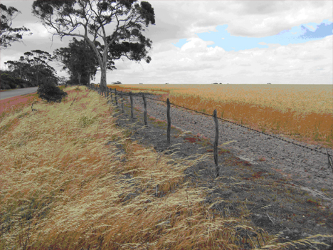
A jam post and plain wire fence (with one run of barb) in the Avon Valley – probably built in the 1920s, photographed in 2004
Full text:
ONE OF THE MOST ubiquitous features of our agricultural districts until a few years ago was the jam post and plain wire fence. Until replaced by modern fences made with manufactured link mesh wire and steel pickets or treated pine posts, jam post and plain wire fences extended over thousands of kilometers throughout the Avon Valley and beyond. They demarcated paddocks and property boundaries and river, road and railway reserves. Many of the jam post and plain wire fences constructed during the early 20th century still stand and perform a useful function today (although usually with a run of ringlock added, and a few steel pickets as supports). Others were over 100 years old at the time they were replaced. These old fences are not only a testimony to the durability and simplicity of the structure, but to the skill and hard work of the people who built them. They also provide insights into the regional economy and ecology and its social history.
One of the finest remnants of early fencing is still to be seen along sections of the York-Greenhills railway reserve, where the original jam posts, heavy gauge wire and cast iron windlass strainers can still be observed. This fence would have been constructed in 1898 when the railway was built (Tilley, 1998).
I am interested in the use of natural resources, especially timber, and I have always been fascinated by the jam wattle (Acacia acuminata) tree and its (mostly unsung) contribution to the development of the farming industry in the Avon districts and beyond. To get a sample of the extent of this contribution, I recently estimated the distance of boundary fencing which followed the subdivision of the Gwambygine Estate. This estate had resulted from the 1890s breakup into farms and homestead blocks of one of the original pastoral leases on the Avon River, south of York. I measured boundary fencing alone and the distance amounted to over 550 kilometers for this single subdivision.
When this figure is extrapolated to subsequent farm development in the York area and along the Avon Valley, together with the knowledge that one kilometer of fencing required 300 posts, 5 (and often 6) kilometers of wire, and strainer posts at every corner and every few hundred metres along the fence, it gives some idea of the extent of the task involved in fence construction, and of the vast resources of timber which were used.
Fences are so much a part of the rural landscape, that they largely go un-noticed. Nor is their history appreciated, or the way in which the development of fencing and the use of timber posts is interconnected with social, ecological and economic history. In reflecting on these issues, it is necessary to go back to the earliest days of settlement.
Impacts Of Earthquake Tsunamis On Oregon Coastal Populations
Leland Gilsen. 2002. Impacts Of Earthquake Tsunamis On Oregon Coastal Populations. Association of Oregon Archaeologists Occasional Papers No. 7, 2002.
Leland Glisen was the State Archaeologist for Oregon from 1978 to 2002 within the State Historic Preservation Office of Oregon State Parks. He has a Ph.D. in Anthropology with a specialization in Archaeology from the University of Arizona. This paper was downloaded and reposted with permission from Dr. Glisen’s excellent website, Oregon-Archaeology [here].
Full text [here]
Selected excerpts:
Introduction
What were the impacts to human populations from great subduction earthquakes and resulting tsunamis? This key question has not been addressed by archaeologists. What happens to population growth curves along the northern California, Oregon, and southern Washington coasts when, on an average of every 572 years, a great-subduction earthquake (between 8 and 9+ on the Richter scale with up to 10 hours of tsunami waves) hits prehistoric settlements?
First, there must have been significant loss of life among the prehistoric populations. Second plant and animal resources would have been disturbed or destroyed to some degree. Third, communication and travel would have been disrupted. Fourth, water transport (canoes) on estuaries and along the coast would have been lost or destroyed. Fifth, shelters (housing) would have been lost or damaged.
If in mid-winter and at night, like the quake of 1700, people would have been in coastal winter villages. They must have faced massive damage when weather conditions were poor. Stored foods may have been lost or damaged. Sites on cliff edges (including winter houses) may have crashed into the sea.
Physical Evidence
Adams (1992) summarized research into quakes in the Seattle area and found local tsunamis in the narrow channels, rock avalanches in the Olympic Mountains that dammed streams to produce lakes, and block landslides in Lake Washington. Atwater and Moore (1992) verified the local Puget Sound tsunamis north of Seattle. Karlin and Abella (1992) found steep basin landslides in Lake Washington in at least three locations that included large block slides that submerged forest habitats. Schuster et al. (1992) suggested that eleven rock avalanches in the southeastern Olympics were the result of quakes. “The rock avalanches that formed Jefferson, Lower Dry Bed, and Spider Lakes, and perhaps Lena Lake, provide evidence that strong shaking accompanied abrupt tectonic displacement in western Washington” (Schuster et al. 1992:1621). Logan and Walsh (1995) documented two drowned forests in lake Sammamish as evidence for one or two large block landslides into the lake as the result of a major earthquake.
So the physical damage from such events must have been massive. But the cultural and social damage must have been just as great. The loss of life in a small scale society would have a disproportionate effect on population growth curves, flattening them out, and modifying the region’s demography. This in turn, would have long term effects on human ecology or population adaptation. With the overall population being hit by periodic episodes of catastrophic death and destruction, there simply was a slower change in carrying capacity and a reduced need for changes in any of the key economic technological systems (production, distribution, consumption, or storage) or political systems (access to, and control over, important resources in the physical, biotic of cultural environmental context). …
Fire, Flogging, Measles and Grass: the influence of early York settlers on bushfire policy in Western Australia
David Ward and Roger Underwood. 2003. Fire, Flogging, Measles and Grass: the influence of early York settlers on bushfire policy in Western Australia. Barladong (4) 2003: 16-27 (Barladong is the journal of the York Historical Society in Western Australia).
Note — this paper is a revision of an earlier paper:
David Ward. 1998. Fire, Flogging, Measles and Grass: Nineteenth Century Land Use Conflict in Southwestern Australia. Dept. of Conservation and Land Management, Western Australia.
Full text of the 1998 paper, which includes references and reprints of colonial correspondence, is [here] (3.6 MB)
Full text of the 2003 paper:
*****
“Nearly fifty-five miles east of Guildford is the new town of York, laid out on locations of fifty acres each, round the base of a conical hill called Mount Bakewell (which is covered with poa-grass)…” — Nathaniel Ogle, “The Colony of Western Australia: A Manual for Emigrants”, 1839
Conflict over land management is common today. Some of our most contentious political and economic issues are between interest groups promoting different, and often conflicting, land uses such as farming, nature conservation, recreation, urban development, forestry, and water catchment. In this paper we examine a particular conflict in the 1840s, especially in the York district, over the traditional use of bushfire by Noongar people. The historical perspective is relevant to present day conflict over fire management.
Before Europeans settled in south-western Australia, the indigenous Noongar people used the land for hunting and gathering. As with other hunter-gatherers in Africa, India, and the Americas, Noongars used fire as a management tool, and had probably done so for tens of thousands of years. The arrival of Europeans whose homesteads, sheds, stock, crops, pastures and haystacks were vulnerable to fire led to immediate conflict: a fire-vulnerable society was seeking to establish itself in an environment in which fire occurred frequently, and was the dominant land management practice.
The importance of frequent fire in the land use and culture of the Noongars has been set out by West Australian scholars such as Associate Professor Sylvia Hallam [1] and Dr. Neville Green [2]. Amongst a wealth of historical references, Sylvia Hallam noted Lt. Bunbury’s [3] estimate of two to three years between bushfires in the parts of the south-west that he had visited in the 1830s. She also noted Major Mitchell’s [4] perceptive comment of 1848, based on observations in other parts of Australia, that
Fire, grass, kangaroos, and human inhabitants, seem all dependent on each other for existence…
Reconstructing Historic Ecotones Using the Public Land Survey: The Lost Prairies of Redwood National Park
Joy A. Fritschle. 2008. Reconstructing Historic Ecotones Using the Public Land Survey: The Lost Prairies of Redwood National Park. Annals of the Association of American Geographers, 98:1, 24-39
Full text [here]
Selected excerpts:
Abstract
Restoration of natural systems depends, in part, on reconstructing historic landscapes to serve as reference ecosystems. The most effective historic landscape reconstruction relies on multiple lines of evidence at different temporal and spatial scales. This study analyzes original Public Land Survey (PLS) records and compares the results with previous work that relied on dendroecology and aerial photograph evidence of vegetation change. Notations in the land survey regarding the location of prairie-woody vegetation ecotones in the Bald Hills of Redwood National Park were transcribed into a geographic information system. Sugihara and Reed (1987) measured the degree of coniferous forest encroachment into prairies and oak woodlands, estimating a 29 percent loss in the spatial extent between 1850 and 1983. The location of 1875–1882 land survey records of ecotones provides evidence that transects across the prairies might have narrowed by as much as 44 percent. Furthermore, this study found evidence of both oak woodland and coniferous forest encroachment into prairies, and that the diminishment of prairies further inland might result primarily from the expansion of oak woodland. A reconstruction of the historic landscape that relies on both field and archival evidence is the best approach to defining reference ecosystems.
Environmentally biased fragmentation of oak savanna habitat on southeastern Vancouver Island, Canada
Mark Vellend, Anne D. Bjorkman, Alan McConchie. 2008. Environmentally biased fragmentation of oak savanna habitat on southeastern Vancouver Island, Canada. Biological Conservation 141(2008) 2576-2584.
Selected Excerpts:
Abstract
Quantifying the degree to which natural or protected areas are representative of a specified baseline provides critical information to conservation prioritization schemes. We report results on southeastern Vancouver Island, Canada, where we compared environmental conditions represented across the entire landscape, in oak savanna habitats prior to European settlement (<1850), and in both protected and unprotected oak savannas in the present-day. In this region, oak savannas represent a rare habitat type, harboring many threatened species. Before European settlement, oak savannas occurred in a distinctly different subset of environmental conditions than they do today. Compared to the entire landscape, oak savannas were historically found predominantly in warm, dry, flat, and low-lying areas, but habitat destruction has left oak savannas in largely the exact opposite set of conditions at present. Thus, the range of conditions in both protected and unprotected oak savannas at present are highly unrepresentative of historical conditions. It appears that fire management by indigenous peoples maintained oak savannas historically across large areas of flat low-lying conditions with deep soils, where succession otherwise produces closed coniferous forest. These areas have since been almost entirely converted to agricultural and urban areas, leaving remnant oak savannas largely on steep, rocky hilltops, where the habitat is maintained by shallow soils. Our results provide quantitative guidance for setting conservation priorities for oak savannas in this region, while highlighting the important general issue of the major role traditional land-use practices can play in shaping landscapes, and therefore in influencing the baselines used to set conservation priorities.
Cultivated Landscapes Cultural Landscapes Fire History Native Cultures
by admin
leave a comment
Evaluating the Purpose, Extent, and Ecological Restoration Applications of Indigenous Burning Practices in Southwestern Washington
Linda Storm and Daniela Shebitz. 2006. Evaluating the Purpose, Extent, and Ecological Restoration Applications of Indigenous Burning Practices in Southwestern Washington. Ecological Restoration, Vol. 24, No. 4, 2006.
Selected excerpts:
Abstract
Understanding the historic fire regime is essential before restoring fire to an ecosystem. Historical ecology provides a means to use both quantitative and qualitative data from different disciplines to address questions about how the traditional ecological management (TEM) practices of indigenous peoples influenced prairie and savanna ecosystems in the past. In this article, we evaluated paleoecological, archaeological, ethnographic, and ethnobotanical information about the Upper Chehalis River basin prairies of southwestern Washington to better understand the extent to which TEM influenced prairie distribution, composition, and availability of wild plant food resources. We also surveyed areas that had been burned at differing frequencies to test whether frequent fires increase camas (Camassia quamash) productivity. Preliminary results support the hypothesis that camas productivity increases with fire-return intervals of one to two years.
Introduction
A number of anthropologists, ethnobotanists, and ecologists now believe that indigenous peoples contributed to the long-term maintenance and distribution of prairie and savanna ecosystems in pre-European western Washington through traditional management techniques, such as burning (Norton 1979a, 1979b; Kruckeberg 1991; Agee 1993; Dunn and Ewing 1997; Boyd 1999a; Leopold and Boyd 1999; Wray and Anderson 2003). Following the decline of indigenous cultures and the subsequent absence of low-intensity, high-frequency fires, areas in western Washington that were once prairies and savannas have naturally succeeded to conifer-dominated forests (Lang 1961).
Today, there are efforts underway to restore the fire-dependent prairies and savannas of western Washington and the many now rare, threatened, and endangered species that continue to exist in those degraded ecosystems (Dunn and Ewing 1997, Chappell and others 2001, Peter and Shebitz 2006).
In this paper, we use a historical ecology methodology to evaluate both the reasons why indigenous peoples in the Upper Chehalis River basin managed prairie and savanna ecosystems and the extent of those practices through time and space. …
Cultivated Landscapes Cultural Landscapes Fire History Native Cultures The Wilderness Myth
by admin
Comments Off
Amazonian Dark Earths: Wim Sombroek’s Vision
William I. Woods (Editor), Wenceslau G. Teixeira (Editor), Johannes Lehmann (Editor), Christoph Steiner (Editor), Antoinette M.G.A. WinklerPrins (Editor), Lilian Rebellato (Editor). 2009. Amazonian Dark Earths: Wim Sombroek’s Vision. Springer; 1st edition (December 1, 2008). 504 pages.
Amazon.com listing [here].
Review by Mike Dubrasich
A landmark book has been published on terra preta, Amazonian dark earths, the carbon-rich soils developed by ancient civilizations in what was once thought to be a pristine wilderness. Dedicated to Dutch soil scientist Wim Sombroek (1934-2003) who was the first modern investigator of terra preta, Amazonian Dark Earths: Wim Sombroek’s Vision is a compilation of the latest, cutting-edge studies in this fascinating and important multi-disciplinary field.
Amazonian soils are predominantly laterites [here], deeply weathered red clays lacking in most soil nutrients. Millions of years of rainfall have leached out everything but iron (hence the red color), silica, and aluminum. Essential plant nutrients such as calcium, phosphorus, and potassium are nearly missing. Amazon vegetation subsists on itself, the thin humus of decaying plant matter being the only source of key metallic oxides.
Except where there is terra preta, or it’s close cousin terra mulata. Terra preta is deep, rich, fertile, black soil that occurs in patches on bluffs along the Amazon and its tributaries. Terra preta is filled with charcoal, ash, mulch, bones, and pottery shards! It is potting soil made from organic matter transported to the sites in pots! These anomalous soils are anthropogenic: people made them.
[Dr. William] Denevan (2001:116–119) has argued that in pre-Columbian times the use of stone axes made long-fallow shifting cultivation very inefficient, and as result probably uncommon until the European introduction of metal axes. Previously, soil fertility must have been maintained and improved by frequent composting, mulching, and in-field burning, making semi-permanent cultivation possible with only brief fallowing. Over time these activities could have produced fertile, self-sustaining dark earths.
Dark earths may occupy 0.1% to 0.3%, or 6,000 to 18,000 km2, of forested lowland Amazonia (Sombroek and Carvalho 2002:130). Because their densities vary greatly within subregions and almost no systematic survey has been accomplished within Amazonia, variations in density projections of an order of magnitude are to be expected. The dark earths occur in a variety of climatic, geologic, and topographic situations, both along river bluffs and in the interior, with depths sometimes exceeding 2.0 m. Individual patches range from 1 ha or so to several hundred hectares. — from Chapter 1, Amazonian Dark Earths: The First Century of Reports by William I. Woods and William M. Denevan
Rather than a pristine, untrammeled, unoccupied wilderness, Amazonia has been home to people for thousands of years. The indigenous residents were agriculturalists who modified soils in order to grow corn (maize), squash, beans, fruiting palms, gourds, pineapples, cotton, arrowroot, and many other cultivated fruits, nuts, tubers, and fibers.
Terra mulata is brownish soil that generally surrounds patches of terra preta. It is not quite as rich and has fewer artifacts, and is even more widespread than terra preta. In theory, terra mulata is the accidentally improved soil adjacent to the deliberately improved soils, or else it is terra preta in the making. In either case, anthropogenically altered soils are in strong contrast to the unaltered laterites, and cover a combined area the size of France.
One of the key elements of terra preta is charcoal, lately termed “biochar”.
Vegetation actively withdraws carbon from the atmosphere and stores it as organic matter. Biochar is created when organic matter is heated without oxygen and it contains twice the carbon content of ordinary biomass (Lehmann 2007). Biochar is much more resistant to decay and can store carbon for centennial timescales (Lehmann et al. 2006). The addition of biochar to the soil was part of the creation of ADE [Amazon dark earths] (Neves et al. 2003). This has lead some to speculate on the viability of a biochar carbon sequestration industry which would reduce atmospheric greenhouse gases (Marris 2006; Sombroek et al. 2002) and improve soil fertility (Lehmann et al. 2003; Glaser and Woods 2004). — from Chapter 14, Locating Amazonian Dark Earths (ADE) Using Satellite Remote Sensing – A Possible Approach by J Thayn, KP Price, and WI Woods.
Biochar is touted as a “solution” to the global warming “problem.” I demure. But biochar is definitely a valuable soil amendment because carbon binds to and stores the metallic oxide nutrients essential to plant growth. The addition of charcoal as well as organic detritus helped to create and sustain terra preta over centuries.
Amazonian Dark Earths: Wim Sombroek’s Vision is a wonderful account of the history and science of anthropogenic soils. The book is as rich as terra preta in literary as well as scientific writing.
The legacy of cultural landscapes in the Brazilian Amazon: implications for biodiversity
Michael J. Heckenberger, J. Christian Russell, Joshua R. Toney, and Morgan J. Schmidt. 2007. The legacy of cultural landscapes in the Brazilian Amazon: implications for biodiversity. Phil. Trans. R. Soc. B (2007) 362, 197–208
Full text [here]
Selected excerpts:
Abstract
For centuries Amazonia has held the Western scientific and popular imagination as a primordial forest, only minimally impacted by small, simple and dispersed groups that inhabit the region. Studies in historical ecology refute this view. Rather than pristine tropical forest, some areas are better viewed as constructed or ‘domesticated’ landscapes, dramatically altered by indigenous groups in the past. This paper reviews recent archaeological research in several areas along the Amazon River with evidence of large pre-European (ca 400–500 calendar years before the present) occupations and large-scale transformations of forest and wetland environments. Research from the southern margins of closed tropical forest, in the headwaters of the Xingu River, are highlighted as an example of constructed nature in the Amazon. In all cases, human influences dramatically altered the distribution, frequency and configurations of biological communities and ecological settings. Findings of historical change and cultural variability, including diverse small to medium-sized complex societies, have clear implications for questions of conservation and sustainability and, specifically, what constitutes ‘hotspots’ of bio-historical diversity in the Amazon region.
INTRODUCTION
The preservation of tropical forests in the Amazon is central to current debates about environmental and climate change across the globe. Greater Amazonia, which refers to the largely forested Orinoco and Amazon river basins, preserves nearly one half of the world’s remaining tropical forests. It contains nearly a quarter of the world’s fresh water and produces roughly one-third of the world’s oxygen, over an area larger than Europe (nearly one-third of South America). According to The Nature Conservancy (TNC website: www.nature.org; consulted 2December 2006), Amazonia is also home to over one-third of the Earth’s known species, and as such is one of the most critical reservoirs of biodiversity on the planet. Not surprisingly, concerns over biological conservation and the future of the region as a critical ‘tipping point’ in the Earth’s climate and ecology are widespread.
The discovery of remarkable variability within Amazonia over the past few decades has overturned popular characterizations of the region as a fairly uniform, impenetrable lowland jungle strangled with plants and teeming with exotic fauna of all kinds. Recent research coupled with the immense power and widespread availability of satellite imagery reveals that, although generally flat and green, there is astonishing biological and ecological variability. …
The documentation of immense biological variation has done little to change stereotypes of the indigenous occupants of the region—as traditionally small-scale and dispersed villages of ’stone-age primitives’ hidden away in forest clearings. The majority opinion still holds that natural forces and processes, little impacted by human actions until recently, are responsible for the current composition of the region. However, appearances are deceiving and, in this case, the present composition of the region as closed forest often masks an environmental history much more complex.
In-depth studies in ethnohistory and archaeology, i.e. studies with sufficient time-depth to evaluate long-term patterns, clearly document that some areas were home to fairly densely settled, highly productive and powerful regional polities in the past. These small to medium-sized complex societies converted many forests into patchy, managed landscapes, which included fairly large-scale transformations of soils, forest plants and animals, and wetlands.
Of Fates, Forests, and Futures: Myths, Epistemes, and Policy in Tropical Conservation
Susanna B. Hecht. 1993. Of Fates, Forests, and Futures: Myths, Epistemes, and Policy in Tropical Conservation. Horace Marden Albright Lecturer in Conservation. UC Berkeley College of Natural Resources
Full text [here]
Selected excerpts
Introduction
In spite of increasingly strident international censure, the global rates of deforestation in the tropical world have more than doubled during the last decade (Myers 1990). This destructive pattern is well advanced in the Western Amazon. In 1980, less than 8,000 km of Rondonia’s forests had fallen. Acre’s forests were largely intact. By the end of the decade some 60,000 km, or 17% of the state of Rondonia had been cleared. In Acre - more distant, fewer roads and more politically organized - by the mid-1990s, some 5% of the lands had been deforested (FUNTAC 1990). Spurred by government colonization programs, fiscal distortions, land speculation, timber concessions, dubious land titles and the migration of almost a million peasants from southern Brazil (World Bank, 1989), forests relentlessly fell. Degraded pastures and abandoned farms soon replaced rich woodlands. Weed invasion, declines in soil fertility, and frontier economics all took their toll as colonists and ranchers pressed ever forward. …
Rapid deforestation and resource degradation are related to the ecological instability and economic peculiarities of the forms of land occupation expressed by current regional development efforts. But why such forms of land use have come to dominate the landscape leads us further to questions that lie at the heart of deforestation: how we understand it, and how we hope to halt it.
What I will do in this article is to explore some of the deeper epistemological issues that inform our models and environmental sciences of how the world unfolds in these regions. While the scientific literature, airwaves and popular culture barrage us with “explanations,” these competing, largely unexamined paradigms have policy and real-world outcomes. I will examine first two broad overarching approaches that have been instrumental in defining resources debates in the first world, how these have articulated with the scientific frameworks that have been significant in interpreting tropical forests and populations as well as their peoples. I will also discuss the emerging counter view. These will then be linked to explanations of deforestation, and their policy consequences.
The Amazon has always been a mirror to the vibrant fantasies of its observers. Any review of its history is always tremendously disconcerting because there are so many disparate versions of Amazonia, in part because the region is so enormous. But as much as it is a forest of trees, it is also in Turner’s phrase “a forest of symbols.” …
Native Americans as active and passive promoters of mast and fruit trees in the eastern USA
Marc D. Abrams, Gregory J. Nowacki. 2008. Native Americans as active and passive promoters of mast and fruit trees in the eastern USA. The Holocene, Vol. 18, No. 7, 1123-1137 (2008)
Full text [here]
Selected excerpts:
Abstract
We reviewed literature in the fields of anthropology, archaeology, ethnobotany, palynology and ecology to try to determine the impacts of Native Americans as active and passive promoters of mast (nuts and acorns) and fruit trees prior to European settlement. Mast was a critical resource for carbohydrates and fat calories and at least 30 tree species and genera were used in the diet of Native Americans, the most important being oak (Quercus), hickory (Carya) and chestnut (Castanea), which dominated much of the eastern forest, and walnut (Juglans) to a lesser extent. Fleshy tree fruits were most accessible in human-disturbed landscapes, and at least 20 fruit- and berry-producing trees were commonly utilized by Native Americans. They regularly used fire and tree girdling as management tools for a multitude of purposes, including land clearing, promotion of favoured mast and fruit trees, vegetation control and pasturage for big-game animals. This latter point also applies to the vast fire-maintained prairie region further west. Native Americans were a much more important ignition source than lightning throughout the eastern USA, except for the extreme Southeast. First-hand accounts often mention mast and fruit trees or orchards in the immediate vicinity of Native American villages and suggest that these trees existed as a direct result of Indian management, including cultivation and planting. We conclude that Native American land-use practices not only had a profound effect on promoting mast and fruit trees but also on the entire historical development of the eastern oak and pine forests, savannas and tall-grass prairies. Although significant climatic change occurred during the Holocene, including the `Mediaeval Warming Period’ and the `Little Ice Age’, we attribute the multimillennia domination of the eastern biome by prairie grasses, berry-producing shrubs and/or mast trees primarily to regular burning and other forms of management by Indians to meet their gastronomic needs. Otherwise, drier prairie and open woodlands would have converted to closed-canopy forests and more mesic mast trees would have succeeded to more shade-tolerant, fire-sensitive trees that are a significantly inferior dietary resource.
Introduction
… Several researchers have concluded that climate is the primary driver of vegetation change in the eastern USA (Parshall and Foster, 2002; Shuman et al., 2004). While we agree with the importance of climate, we also believe that the impact and extent of early Native American land use in shaping vegetation types is more substantial than previously thought. The large disparity in presettlement vegetation expression between climax forests (set by climatic controls) and that of shade-intolerant, disturbance based vegetation types strongly points toward human intervention (Stewart, 2002; Nowacki and Abrams, 2008). Indeed, vegetation modification by Native American burning and agricultural land clearance has been particularly well documented (Cronan, 1983; Pyne, 1983; Williams, 1989; Whitney, 1994; Bonnickson, 2000).
For example, forests dominated by oak, chestnut, hickory and pine prior to European settlement are thought to require periodic fire for continued recruitment and long-term success (Abrams, 1992; Lorimer, 2001). Bromley (1935) concluded that Native American populations in southern New England were of sufficient size to burn most of the landscape on a recurring and systematic basis. Indians regularly used broadcast burning to clear forest undergrowth, prepare croplands, facilitate travel, reduce vermin and weeds, increase mast production and improve hunting opportunities by stimulating forage and driving or encircling game (Whitney, 1994; Stewart, 2002; Williams, 2002). Accidental wildfires also occurred from escaped camp and signal fires and burned into the surrounding forests. Once fires were set, there was little incentive or means by which to put them out (Stewart, 2002).
During the latter part of the Holocene, Native Americans planted a wide variety of crop species in well-managed agricultural fields adjacent to their villages (Trigger, 1978; Fogelson, 2004). MacDougall (2003) lists a total of 35 herbaceous plant species cultivated by eastern Native Americans. By the sixteenth century, the most abundant crops were maize, beans and squash, known as the ‘Three Sisters’ when planted together (Martinez, 2007). In contrast to our understanding of Native American use of fire and the cultivation of crops, we know very little about their direct and indirect impacts on the distribution of the mast and fruit trees that were important in their seasonal diet. If Native Americans had the skills to develop sophisticated systems of agriculture, did they possess similar skills to manage forests?
The promotion of mast and fruit trees would have involved active silviculture and horticulture such as reducing competing vegetation via girdling, cutting or prescribed fire and the planting and tending of beneficial tree species, possibly even creating fruit or mast orchards (Delcourt and Delcourt, 2004). The passive promotion of certain trees could have stemmed from various land uses intended for other purposes, such as broadcast fire for reducing undergrowth for security and travel, game management and general land clearance. It also could have resulted from village and agricultural field abandonment. Important mast trees used by Native Americans in the eastern USA included oak, hickory, beech (Fagus), chestnut and walnut (Juglans), species that dominated many presettlement forests. Prairies dominated much of the Central Plains and Midwest prior to European settlement, also as result of Indian burning (Sauer, 1975; Stewart, 2002). Prairie sustained huge populations of large ungulate species of Bison, deer (Odocoileus) and elk (Cervus) that were vital to the Indian diet. In any given part of the eastern USA, various vegetation types or stages may exist depending on the climate, site conditions, disturbance regime and successional status. It is important to know to what extent the dominance of mast trees and prairie were a result of Native American land use and disturbance, whether either directly or indirectly, and to what extent these were created and maintained to meet dietary needs.
The purpose of this paper is to explore the role of Native Americans in the active and passive promotion of dietary mast and fruit trees and prairie in the eastern USA, and to determine to what extent their practices shaped the overall vegetation prior to European settlement. We explore the hypothesis that Native American land-use management was focused on the creation of large expanses of specific forest and prairie to meet their dietary needs. This will be accomplished by:
(1) synthesizing palaeoecological information on the long-term vegetation dynamics and climate during the latter part of the Holocene;
(2) comparing Native American ignitions to natural (lightning) sources;
(3) exploring ethnobotany and anthropology studies on the dietary uses of mast and fruit trees by Native Americans;
(4) reconstructing vegetation composition at the time of European settlement and ascertaining to what extent it was a result of Native American activities;
(5) documenting Native American land-use and vegetation management that has played a direct (active) or indirect (passive) role in promoting dietary mast and fruit trees in the USA. …
Selected References
Bonnicksen, T.M. 2000: America’s ancient forests. John Wiley and Sons, 594 pp.
Bonnicksen, T.M., Anderson, M.K., Lewis, H.T., Kay, C.E. and Knudson, R. 2000: American Indian influences on the development of forest ecosystems. In Johnson, N.C., Malk, A.J., Sexton, W.T. and Szaro, R., editors, Ecological stewardship: a common reference for ecosystem management. Elsevier Science Ltd, 67 pp.
Day, G.M. 1953: The Indian as an ecological factor. Ecology 34, 329–46.
Delcourt, P.A. and Delcourt, H.R. 2004: Prehistoric native Americans and ecological change. Cambridge University Press, 203 pp.
Doolittle, W.E. 1992: Agriculture in North America on the eve of contact: a reassessment. Annals of the Association of American Geographers 82, 386–401.
Guyette, R.P., Muzika, R.M. and Dey, D.C. 2002: Dynamics of an anthropogenic fire regime. Ecosystems 5, 472–86.
Kay, C.E. 2000: Native burning in western North America: implications for hardwood forest management. In Yaussy, D.A., compiler, Proceedings: workshop on fire, people, and the central hardwoods landscape; 2000 March 12–14, Richmond, KY. USDA Forest Service General Technical Report NE-274, 19–27.
Kay, C.E. 2007: Are lightning fires unnatural? A comparison of Aboriginal and lightning ignition rates in the United States. In Masters, R.E. and Galley, K.E.M., editors, Proceedings of the 23rd Tall Timbers fire ecology conference: fire in grassland and shrubland ecosystems. Tall Timbers Research Station, 16–28.
Lewis, H.T. 1993: Patterns of Indian burning in California: ecology and ethnohistory. In Blackburn, T.C. and Anderson, K., editors, Before the wilderness: environmental management by Native Californians. Ballena Press, 55–116.
Lewis, H.T. and Anderson, M.K. 2002: Introduction. In Lewis, H.T. and Anderson, M.K., editors, Forgotten fires: Native Americans and the transient wilderness. University of Oklahoma Press, 3–16.
Mann, C.C. 2005: 1491. Vintage Books.
Pielou, E.C. 1991: After the Ice Age: the return of life to glaciated North America. University of Chicago Press.
Pyne, S.J. 1983: Indian fires. Natural History 2, 6–11.
Pyne, S.J. 2001: The fires this time, and next. Science 294, 1005–1006.
Raup, H.M. 1937: Recent changes of climate and vegetation in southern New England and adjacent New York. Journal of the Arnold Arboretum 18, 79–117.
Sauer, C.O. 1975:Man’s dominance by use of fire. Geoscience and Man 10, 1–13.
Stewart, O.C. 2002: The effects of burning of grasslands and forests by aborigines the world over. In Lewis, H.T. and Anderson, M.K., editors, Forgotten fires: Native Americans and the transient wilderness. University of Oklahoma Press, 67–338.
Williams, G.W. 2002: Aboriginal use of fire: are there any ‘natural’ plant communities? In Kay, C.E. and Simmons, R.T., editors, Wilderness and political ecology: Aboriginal land management – myths and reality. University of Utah Press, 48 pp.
History of the Jarbidge, Nevada, Area
St. Louis, Bob. 2008. History of the Jarbidge, Nevada, Area With Special Emphasis on Matters Pertaining to the South Canyon Section of Jarbidge Road. Western Institute for Study of the Environment
I. Introduction
For almost one hundred years, the Jarbidge area has been the center of numerous controversies. At the turn of the century, the issue was federal protection for interests of local ranchers and other inhabitants against a wave of invading sheepmen. After gold was discovered in the area, the issue became one of local miners petitioning the federal government for a townsite. Later on, part of the area was set aside as Nevada’s first designated wilderness. Subsequently, the Forest Service set upon a crusade to expand that wilderness, in spite of local residents’ objections. Still later, the Jarbidge Wilderness was expanded after the Forest Service unilaterally closed a segment of South Canyon Road. In most recent times, Jarbidge townspeople had to appeal to Congress in order to remove Forest Service authority over their cemetery. The latest controversy returns to an earlier issue: the Forest Service once again attempted to create a de facto wilderness by closing another segment of South Canyon Road.
The following chronicle documents the history of the South Canyon of the Jarbidge River, from the perspective of the on and off relationship between the federal government and the local residents. It is not intended to be a thorough study of the history of this part of Nevada, but rather a detailed introduction into how the role of the federal government has been transformed from the “government of the people, by the people” to a self-serving entity that disregards the interests, and laws, of the local citizenry.
Cultivated Landscapes Cultural Landscapes The Wilderness Myth
by admin
Comments Off
The Pristine Myth: The Landscape of the Americas in 1492
William Denevan. 1992. The Pristine Myth: The Landscape of the Americas in 1492. Annals of the American Association of Geographers v. 82 n. 3 (Sept. 1992), pp. 369-385.
Full text [here]
Much of the environmental movement is animated, consciously or not, by what geographer William Denevan calls “the pristine myth”—the belief that the Americas in 1491 were an almost untouched, even Edenic land, “untrammeled by man,” in the words of the Wilderness Act of 1964, a U.S. law that is one of the founding documents of the global environmental movement. - Charles C. Mann, 1491: New Revelations of the Americas Before Columbus.
Selected excerpts:
Abstract. The myth persists that in 1492 the Americas were a sparsely populated wilderness, a world of barely perceptible human disturbance. There is substantial evidence, however, that the Native American landscape of the early sixteenth century was a humanized landscape almost everywhere. Populations were large. Forest composition had been modified, grasslands had been created, wildlife disrupted, and erosion was severe in places. Earthworks, roads, fields, and settlements were ubiquitous. With Indian depopulation in the wake of Old World disease, the environment recovered in many areas. A good argument can be made that the human presence was less visible in 1750 than it was in 1492.
What was the New World like at the time of Columbus? “Geography as it was,” in the words of Carl Sauer (1971). The Admiral himself spoke of a “Terrestrial Paradise,” beautiful and green and fertile, teeming with birds, with naked people living there whom he called “Indians.” But was the landscape encountered in the sixteenth century primarily pristine, virgin, a wilderness, nearly empty of people, or was it a humanized landscape, with the imprint of native Americans being dramatic and persistent? The former still seems to be the more common view, but the latter may be more accurate.
The pristine view is to a large extent an invention of nineteenth-century romanticist and primitivist writers such as W.H. Hudson, Cooper, Thoreau, Longfellow, and Parkman, and painters such as Catlin and Church. The wilderness image has since become part of the American heritage, associated “with a heroic pioneer past in need of preservation” (Pyne 1982, Bowden 1992). The pristine view was restated clearly in 1950 by John Bakeless in his book The Eyes of Discovery:
There were not really very many of these redmen … the land seemed empty to invaders who came from settled Europe . . . that ancient, primeval, undisturbed wilderness . . . the streams simply boiled with fish … so much game . . . that one hunter counted a thousand animals near a single salt lick … the virgin wilderness of Kentucky … the forested glory of primitive America (Bakeless 1950).
But then he mentions that Indian “prairie fires . . . cause the often-mentioned oak openings … Great fields of corn spread in all directions … the Barrens … without forest,” and that “Early Ohio settlers found that they could drive about through the forests with sleds and horses” (Ibid). A contradiction?
In the ensuing forty years, scholarship has shown that Indian populations in the Americas were substantial, that the forests had indeed been altered, that landscape change was commonplace. This message, however, seems not to have reached the public through texts, essays, or talks by both academics and popularizers who have a responsibility to know better. …
Before The Wilderness: Environmental Management by Native Californians
Blackburn, Thomas C. and Kat Anderson, eds. Before The Wilderness: Environmental Management by Native Californians. 1993. Malki Press - Ballena Press
Selected Excerpts:
CONTENTS
1. INTRODUCTION: MANAGING THE DOMESTICATED ENVIRONMENT
By Thomas Blackburn and Kat Anderson
We did not think of the great open plains, the beautiful rolling hills and the winding streams with tangled growth as ‘wild.’ Only to the white man was nature a`wilderness’ and …the land ‘infested’ with ‘wild’ animals and `savage’ people [Standing Bear, Ogalala Sioux, quoted in Nash 1982].
I have no difficulty in accepting certain spiritual entities in the landscape as domesticated, for the purpose of understanding human action. In the Cape York Peninsula such entities and forces lose their domesticatory qualities when humans are removed from the landscape, and interaction ceases. It is only then that the entire landscape in all its empirical and non-empirical diversity is considered by Aboriginal people to have ‘come wild’ and, thus, to have become potentially dangerous for humans who have lost the practical knowledge for ‘correct’ (i.e., authorized) interaction [Chase 1989:47-8].
During the last two decades, a quiet but nonetheless significant transformation has been occurring in the study of past and present human subsistence systems, and consequently in our understanding of such related (and possibly interrelated) issues as changes in demographic factors, the evolution of complex social and political forms, and the origins and spread of specialized agroecosystems dependent upon domesticated species of plants and animals. A new appreciation for the diversity and potential complexity of nonagricultural economies, in conjunction with a better understanding of the often sophisticated systems of traditional knowledge upon which they are based, has led to a growing recognition that the rigid and rather monolithic conceptual dichotomy traditionally drawn between the seemingly passive `food procurement’ lifestyle of ‘hunter-gatherers’ and the apparently more active `food production’ adaptation of ‘agriculturalists’ is inadequate, overly simplistic, and dangerously misleading. Instead, human adaptive systems increasingly are being seen as occurring along a complex gradient and/or continuum, involving more and more intensive interaction between people and their environment, progressively greater inputs of human energy per area of land, and an expanding capacity to modify or transform natural ecosystems (e.g., Harris 1989)…
Some papers [in this volume] focus rather narrowly on particular techniques of resource utilization or on the micromanagement of individual species, while others discuss the broad management of entire plant communities, resource groups, or populations. Although the evidence that is adduced by the various authors is occasionally fragmentary, and too often more suggestive than decisive, the cumulative effect is compelling, and the final conclusion that emerges seems inescapable and unequivocal: the extremely rich, diverse, and apparently `wild’ landscape that so impressed Europeans at the time of contact-and which traditionally has been viewed as a `natural, untrammeled wilderness’ ever since-was to some extent actually a product of (and more importantly dependent upon) deliberate human intervention. In other words, particular habitats-in a number of important respects-had been domesticated…