Greatest Arctic Ice Extent On Satellite Record
Arctic sea ice has reached its greatest extent since accurate satellite measurements have been made, according to the Centre for Ocean and Ice, Danish Meteorological Institute [here].
Current Sea Ice extent
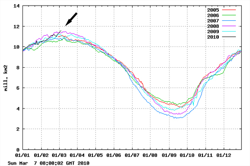
Total sea ice extent on the northern hemisphere since 2005. The ice extent values are calculated from the ice type data from the Ocean and Sea Ice, Satellite Application Facility (OSISAF), where areas with ice concentration higher than 30% are classified as ice.
The total area of sea ice is the sum of First Year Ice (FYI), Multi Year Ice (MYI) and the area of ambiguous ice types, from the OSISAF ice type product. However, the total estimated ice area is underestimated due to unclassified coastal regions where mixed land/sea pixels confuse the applied ice type algorithm. The shown sea ice extent values are therefore recommended be used qualitatively in relation to ice extent values from other years shown in the figure.
Note: Richard B. points out in the comments that the ice extent today is not as great as in 2002, the first year that accurate satellite data was collected.
Sea-Ice Monitor, a website displaying the daily reports of sea ice as recorded by the AMSR satellites, presents a more detailed graph going back to 2002 [here]. It shows that 2010 ice is of greater extent than all years except 2008 which it now seems to match, and 2002 which still displays the greatest amount of ice since the AMSR satellites were launched the same year.
These satellites are operated by IARC-JAXA Information Systems, a combined entity of the International Arctic Research Center and the the Japan Aerospace Exploration Agency (JAXA). The satellites use a sensor developed by JAXA.
Satellite data from 1979 to 2002 came only from Defense Department satellites that NSIDC admits were not designed for sophisticated scientific research and are not as accurate as AMSR satellites. They have been operating for over 30 years. The DOD satellites failed to record 500,000 sq. km of ice existing in Hudson Bay at the beginning of 2009. Read the NSIDC’s explanation of this failure [here] and see if its explanation for continuing to use the data from the older satellites makes sense.