Location: the South Sierra Wilderness on the Kern Plateau, Sequoia NF, Tulare Co. CA
Specific Location: 8 miles north of Kennedy Meadows
Date of Origin: 05/31/2008 at 1455 hrs.
Cause: Lightning
Situation as of 06/16/08 6:00 PM
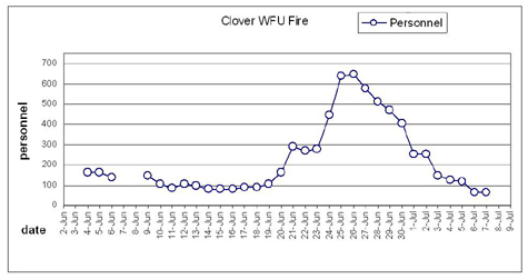
Total Personnel: 84
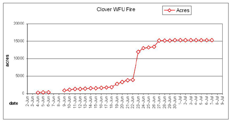
Size: 1,670 acres
Percent Contained: unreported
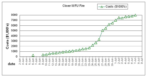
Costs to Date: $985,000
Significant Events: Finishing construction of handline to check any southerly fire spread Improving Jackass Trail for packtrain access. Developing Stage III WFIP. (So far that plan has been in development since 06/09, a week — admin).
Remarks: Fire Behavior Assessment Team will begin monitoring fire behavior and effects tomorrow. (What have they been doing since they arrived on 06/11? — admin).
***************
Situation as of 06/15/08 6:00 PM
Total Personnel: 81
Size: 1,597 acres
Percent Contained: unreported
Costs to Date: $873,000
***************
Situation as of 06/14/08 6:00 PM
Total Personnel: 81
Size: 1,570 acres
Percent Contained: unreported
Costs to Date: $740,000
***************
Situation as of 06/13/08 6:00 PM
Total Personnel: 99
Size: 1,478 acres
Percent Contained: unreported
Costs to Date: $700,000
***************
Situation as of 06/12/08 5:00 PM
Total Personnel: 108
Size: 1,311 acres
Percent Contained: unreported
Costs to Date: $650,000
***************
Situation as of 06/11/08 PM
Total Personnel: 85
Size: 1,311 acres
Percent Contained: unreported
Costs to Date: $600,000
Fire is being monitored.
***************
Situation as of 06/11/08 AM
Total Personnel: 60
Size: 1,164+ acres
Percent Contained: 30%
Individual and group tree torching in 25 mph winds. Personnel continue to monitor fire progression, fire effects and behavior, and smoke.
For further information, please contact Cindy Thill, Public Affairs Officer, Kern River Ranger District at (760) 376-3781.
***************
Vicinity maps:

Clover WFU Fire map 06/04/08 but updated to fire size of ~800 acres. Courtesy InciWeb.

Honeybee WFU Fire map (red) of 05/15/08 but updated to fire size of ~1200 acres. Clover Fire in yellow (~800 acs). Note that each square section on the map is 640 acres. Honeybee WFU Fire updates [here]. Courtesy InciWeb and the Inyo NF.
***************
Situation as of 06/10/08
Total Personnel: 105
Size: 1,164 acres
Percent Contained: 30%
Costs to Date: $400,000
RED FLAG WARNING IN EFFECT FROM 11 AM THIS MORNING TO 9 PM THIS EVENING. WEST WIND 15 TO 25 MPH WITH GUSTS TO 40 MPH.
USFS removed firefighting crews today at 1800 hours. Clover Fire now officially in Let It Burn status.
***************
Situation as of 06/09/08
Total Personnel: 47
Size: 983 acres
Percent Contained: 30%
Costs to Date: $350,000
Pacific Crest Trail open, firefighters assisting hikers through the fire.
Fire made a 350 + acre run 06/08/08 and moved north out of Crag Creek, and 200 additional acres burned today. Expected growth up to 300 acres per day for the next 3 days.
***************
The Clover Fire has been declared a “wildland fire-use” fire as of 06/06/08.
From InciWeb: Upon initial investigation the probable cause of fire appeared to be human-caused. Further investigation has revealed the cause more likely to be lightning. Each lightning caused fire is evaluated to determine the optimal response (suppression or fire use). When making decisions, fire managers consider the fire’s proximity to private property, potential smoke impacts, fire fighter safety, and other fire activity occurring in the area. The main focus for fire fighting personnel still remains to hold the fire from spreading south toward the community of Kennedy Meadows.
No NEPA process was instigated or even contemplated for this Federal management action on public property. No evaluation of impact to endangered species, water or air quality, no public hearings, no public input, and no legal review whatsoever was performed.
No actual detection or investigation of the fire ignition was done.
From InciWeb: Initial investigation into the lightning detection/reporting program did not show recent strikes in the Clover Fire vicinity. The detection program is a computer program which may have not recorded all strikes due to a glitch in the system.
Situation as of 06/06/08 at 2 pm
Total Personnel: 140
Size: 382 acres
Percent Contained: 30%
Active fire on the north side. High winds reported.
Costs to Date: $250,000
***************
Situation as of 06/05/08
Total Personnel: 165
Size: 382 acres
Percent Contained: 30%
***************
Current Situation
Total Personnel: 165
Size: 339 acres
Percent Contained: 30%
Summary: same vicinity as the Honeybee Fire [here].
The Pacific Crest Trail will remain OPEN with a “warning sign” posted for public safety. Hikers in the fire area will be escorted, during daylight hours only, through the fire area. The escorted section is approximately 3/4 of a mile. It is highly discouraged to try and hike in the area after dark - many hikers have mistaken the fireline for the trail and put themselves in a dangerous situation.
Fire crews are constructing direct line as much as possible, securing the south end. Active fire in brush on the north end.
Red Flag Warning in effect until 8 pm PST June 4 for strong winds and low relative humidity over much of southeast California. Wind gusts predicted up to 30 mph. A cold front moving through is producing very windy conditions and isolated thunderstorms. Winds are expected to subside by morning as the front moves through the region.
June 15, 2008 | Topic: California
