Fuel treatments, fire suppression - Warm Lake
Graham, Russell T.; Jain, Theresa B.; Loseke, Mark. 2009. Fuel treatments, fire suppression, and their interaction with wildfire and its impacts: the Warm Lake experience during the Cascade Complex of wildfires in central Idaho, 2007. Gen. Tech. Rep. RMRS-GTR-229. Fort Collins, CO: U.S. Department of Agriculture, Forest Service, Rocky Mountain Research Station. 36 p.
Full text [here] (9.3MB)
Selected excerpts:
Abstract
Wildfires during the summer of 2007 burned over 500,000 acres within central Idaho. These fires burned around and through over 8,000 acres of fuel treatments designed to offer protection from wildfire to over 70 summer homes and other buildings located near Warm Lake. This area east of Cascade, Idaho, exemplifies the difficulty of designing and implementing fuel treatments in the many remote wildland urban interface settings that occur throughout the western United States. The Cascade Complex of wildfires burned for weeks, resisted control, were driven by strong dry winds, burned tinder dry forests, and only burned two rustic structures. This outcome was largely due to the existence of the fuel treatments and how they interacted with suppression activities. In addition to modifying wildfire intensity, the burn severity to vegetation and soils within the areas where the fuels were treated was generally less compared to neighboring areas where the fuels were not treated. This paper examines how the Monumental and North Fork Fires behaved and interacted with fuel treatments, suppression activities, topographical conditions, and the short- and long-term weather conditions.
Introduction
The Payette Crest and Salmon River Mountain ranges of central Idaho create rugged and diverse landscapes. The highest elevations often exceed 10,000 ft with large portions ranging from 5,500 to 6,500 ft above sea level. The Salmon River and its tributaries dissect these mountains creating an abundance of steep side slopes. The South Fork of the Salmon River, with its origin within the 6,000- to 7,000-ft mountains east of Cascade, Idaho, flows north until it joins the main Salmon at an elevation of 2,100 ft. At 5,300 ft, the Warm Lake Basin near the South Fork’s origin is one of the many large and relatively flat basins that occur in central Idaho (Alt and Hyndman 1989; Steele and others 1981) (fig. 1). …
Forest Treatments in the Wildland Urban Interface Near Warm Lake
A large proportion (>66%) of Idaho lands are owned and/or administered by state and federal governments (NRCM 2008). In addition, there are over 30,000 residences located on lands in the wildland urban interface (WUI) with many of these residences being on lands leased from state or federal governments. Valley County, located in the central part of the Idaho, has over 2,200 residences located in the WUI with a concentration of structures near Warm Lake (Headwaters Economics 2007) (fig. 1). Within the Warm Lake area, approximately 20 miles northeast of Cascade, there are roughly 70 residences and other structures (fig. 3). In addition to the summer homes, the area contains two commercial lodges, two organizational camps, and a Forest Service Project Camp. The Warm Lake Basin is the headwater for the Salmon River, which is home to both Chinook salmon (Oncorhynchu tshawytscha) and steelhead trout (Oncorhynchus mykiss). Both species are listed as threatened under the Endangered Species Act, which highlights the Salmon River’s ecological and commercial value. Because of these threatened species, the amount of vegetative manipulation occurring within the Salmon River drainage since the mid-1970s has been minimal (USDA Forest Service 2003).
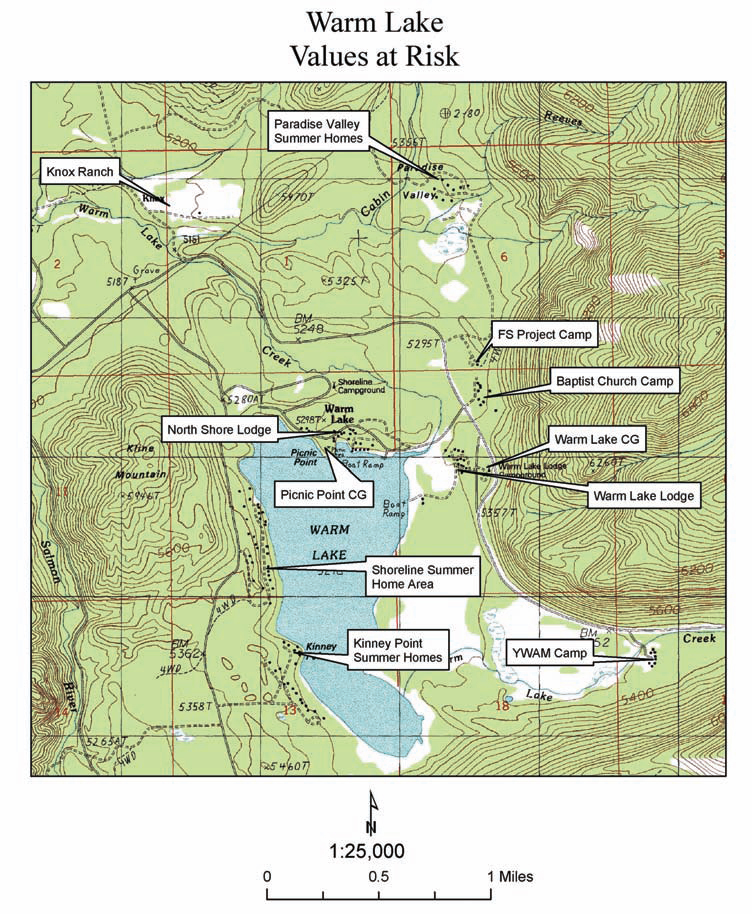
Figure 3. Several homes, lodges, camp grounds (CG), Forest Service camps (FS), and other developments are located within the Warm Lake area of central Idaho. Click map for larger image.
… Beginning in 1996, forest treatments were designed and implemented to reduce the risk of a wildfire adversely affecting the structures and other areas of value within the basin. Because the prevailing winds blow from the south and southwest, a priority was to treat fuels west, south, and southwest of residences in the Kinney Point and Shoreline area along the west shore of Warm Lake (fig. 6). In addition to these areas, the fuels south, west, and east of the Paradise Valley summer homes, Forest Service Project Camp, and Baptist Church Camp located northeast of Warm Lake were treated.
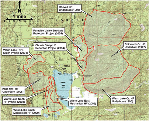
Figure 6. Forest structures and compositions (hazardous fuels – HF) near Warm Lake were modified using both prescribed fire and mechanical methods to modify both wildfire intensity and burn severity if a wildfire was to occur. The treatments were located and designed to offer protection to the many residences and other structures of value near the lake.
… Prescribed fires were the first fuel treatments used in and near the Warm Lake Basin, starting with the Warm Lake Creek Burn in 1996 (fig. 7). Seven burns ranging from 438 acres to over 2,300 acres were conducted, and by 2006, a total of 8,328 acres were burned (table 1). …
The Warm Lake south, north, and east projects treated lodgepole pine forests near the cabins along the lake shore (fig. 6, table 2). Similar to the prescribed fires, these mechanical treatments [767 acres, 2000-2005] cleaned the forest floor and removed ladder fuels. In addition, the spacing between tree boles was increased to approximately 10 to 15 ft, thereby increasing the distance between tree canopies. The lower limbs of the residual trees were pruned to a height of 5 ft, further reducing the ladder fuels. The unwanted trees were cut (slashed), as was the material on the forest floor (up to 12 inches in diameter), into lengths that could be hand-piled. All of the cut material was piled and the covered piles were burned either in the late fall or early spring. Because of the urban setting, the burning piles were attended to ensure that the majority (>80%) of the material was consumed to leave a clean and well kept look to the forest floor (fig. 8). …
Wildfire and Fuel Treatment Interactions Near Warm Lake
… At the time the Monumental and North Fork Fires were burning, the fuels in the Warm Lake vicinity were extremely dry. Dead 1000 hour fuel moisture concentrations averaged 9%, dead 100 (=1.0< 3.0 inches) hour fuel concentrations averaged less than 6%, as did the moisture concentrations of the 10 hour (=0.25< 1.0 inch) fuels…
The fires in and around the Warm Lake Basin increased in size and complexity and, by August 1, over 40,000 acres had burned. For the next 10 days, the Monumental Fire, often driven by strong winds and supported by many days with single digit relative humidity readings, continued burning in a northerly direction toward Warm Lake (figs. 15, 17). The North Fork Fire, driven by the same windy and dry conditions with peak wind gusts exceeding 40 mi/hr, tended to move to the east and northeast. In addition, on August 9, the Monumental Fire made one run 5 miles to the northeast and a second run 1 1/2 mi to the north (fig. 15). In addition to these two fires, the Sandy and Riordan Fires located to the east of Warm Lake continued to burn aggressively, potentially impacting the Warm Lake area and its inherent property and resource values from all directions (fig. 15). The forest treatments aimed at minimizing the impacts from unwanted fire in the area would be put to the test in earnest beginning on August 12. …
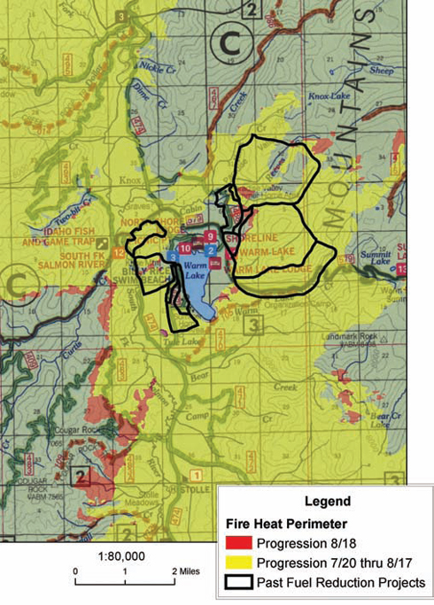
Figure 35. By August 18, the Monumental and North Fork Fires, while burning near Warm Lake, burned through or approached over 5,000 acres (outlined) that were treated to influence both fire behavior and burn severity.
… Where the fuels had been treated, fire behavior was often noticeably different from that which occurred in neighboring untreated fuels. … During the inversion, burnout operations in areas where fuels were treated were very effective and created low intensity, easily managed surface fires (fig. 19). In contrast, during the inversion, rather intense fires were often created during burnout operations with the torching and crowning in fuels that were not treated (fig. 26).
Fuel Treatments and Suppression Activities
Not only did the presence of the fuel treatments directly impact the survivability of the many structures located within the basin, but they also influenced fire suppression strategies and the location of the Incident Command Post (Bull and others 2007). … Knowing that the fire intensity was most likely going to be low to moderate in the areas where the fuels were treated led to the prioritization of both firefighting resources and specific tactics during the fires. For example, mechanical fuel treatments to the south and west of the Kinney Point summer homes were critical in determining where burnout operations were applied (figs. 18, 19). These treatments had a very positive effect on protection capability of these homes, especially when the Monumental Fire intensely approached on August 13 and 17 (figs. 22, 32, 33). These treated areas, along with those on Kline Mountain, were responsible for markedly decreased fire intensity, which allowed fire crews to easily suppress the many spots that were ignited in the fuel treatments. Often these spot fires were near one of the many summer homes located in the area. The fuel treatment areas, in addition to Warm Lake itself, often provided a safe zone for firefighters as the fire(s) burned. …
Within the Paradise Valley summer home vicinity (northeast of Warm Lake), the location and presence of fuels treatment areas also influenced suppression activities (fig. 38). Both hand- and mechanical-fire line constructions used the presence and location of the fuel treatments to determine line locations (fig. 38). Similar to areas along the lake, numerous spots were ignited by the North Fork Fire in the Paradise Valley summer homes, Project Work Camp, and Church Camp fuel treatment areas and they were easily suppressed (fig. 39). As with near the lake, burnout operations could be safely executed where the fuels had been treated. This strengthened protection to that already offered by the fuel treatments to the homes and other buildings in the area. …
Conclusions
The Forest Service and cooperators spent over $1.6 million treating the fuels near Warm Lake. The treatments were strategically placed to offer protection to the many summer homes and other values at risk to wildfire in the area (figs. 3, 4, 6). As a result, the North Fork and Monumental Fires burned only two rustic buildings. Depending on their veracity and longevity, the fuel treatments disrupted the progress of both the Monumental and North Fork wildfires and influenced the burn severity or what was left after the fires (Jain and Graham 2007; Jain and others 2008). Contrary to what is often expected, the fuel treatments did not stop the progression of either fire and when combined, the fires burned over 150,000 acres (fig. 35).
By modifying the fires’ behavior, the fuel treatments presented suppression opportunities that otherwise may not have been available. These opportunities included providing locales to conduct burnouts to locating both hand and machine constructed fire lines (figs. 38, 45). The presence of the Warm Lake Highway mechanical fuel treatment contributed to the decision to keep Incident Command Post in Knox Ranch as the North Fork Fire approached (figs. 27, 28) (Bull and others 2007). Similarly, the mechanical fuel treatments in the Kinney Point area along the west side of the lake were the preferred locations for burnouts and fire line construction, as were the treatment areas near the Paradise Valley summer homes (figs. 19, 38, 45).
The intensity of the North Fork and Monumental Fires, in general, was lower on areas where the fuels had been treated compared to areas where they had not, regardless of whether the burning occurred during a burnout or one of the wildfires (figs. 41, 42, 44, 45). In particular, the mechanical fuel treatments were very effective in creating conditions where surface fires dominated. Because of the lower intensity observed in these areas, they often provided safe zones for firefighters and crews were able to readily suppress the numerous spot fires that often occurred (fig. 39). Wildfire spread rates were not lower in areas where the fuels were treated compared to areas where they were not. For example, the prescribed fire conducted in 1996 along Warm Lake Creek opened the stand and led to the development of a lush herbaceous layer (fig. 6). These fuel conditions were very receptive to ignition and rapid fire spread (figs. 22, 23). …
While the Monumental and North Fork Fires burned in the Warm Lake Basin, the disposition of surface fuels was a major determinant of how the fires progressed. Minimal independent crown fire was evident in the mechanical fuel treatment areas even as the North Fork Fire made its major run toward Knox Ranch (fig. 46). Tree crowns were scorched and burned by surface fires in areas where the fuels were masticated and by the burning of adjacent untreated fuels. …
The way the North Fork and Monumental Fires interacted with fuel treatments, roads, and associated suppression efforts reinforce that treatment location and juxtaposition and the treatment of surface fuels, ladder fuels, and crown fuels (in this order of importance) are major determinants of both wildfire intensity and burn severity (fig. 46) (Agee 1993; Finney 2001; Finney and others 2003; Graham and others 2004; Jain and others 2008; Robichaud and others 2003).