Tea Fire
Location: Montecito, Santa Barbara Co. CA
Specific Location: Cold Springs Creek and Hot Springs Road
Date of Origin: 11/13/2008
Cause: Under investigation
Situation as 11/17/2008 at 6:30 PM
Personnel: 756
Size: 1,940 acres
Percent contained: 100%
Cost to Date: $5.7 million
100 percent containment achieved this evening. Significant mop up, damage assessment, and fire clean up remains. Traffic restricted for public safety.
***************
Situation as 11/17/2008 at 7:00 AM
Personnel: 1,338
Size: 1,940 acres
Percent contained: 95%
Some evacuations remain (countering last night’s announcement). Portions of the fire area have been repopulated.
***************
Situation as 11/16/2008 at 6:30 PM
Personnel: 1,338
Size: 1,940 acres
Percent contained: 80%
Costs to Date: $4,600,000
No current evacuations
Intermittent loss of power to the communities of Montecito, Santa Barbara City and Santa Barbara County while power lines are being repaired.
***************
Situation as 11/16/2008 at 7:00 AM
Personnel: 1,957
Size: 1,940 acres
Percent contained: 75%
210 residences have been destroyed, and 9 have been damaged.
Minimal threat remains. Continue direct control line, mop-up and structure protection as needed. Damage assessment teams will continue to assess affected jurisdictions for damaged and or destroyed homes. Fire line suppression repair will continue. Anticipate demobilization of excess resources to assist with other fires in Southern California.
***************
Situation as 11/15/2008 at 6:00 PM (official CalFire Update)
Personnel: 1,953
Size: 1,940 acres
Percent contained: 60%
210 residences have been destroyed, and 9 have been damaged. 1,500 residences currently threatened.
Mandatory evacuations in Montecito, Santa Barbara City and areas within Santa Barbara County. A Red Flag Alert remains in effect in Santa Barbara County. Intermittent loss of power to the communities of Montecito, Santa Barbara City and Santa Barbara County while power lines are being repaired.
Favorable weather has allowed firefighters to make progress on portions of the fire.
***************
Situation as 11/15/2008 at 7:00 AM (official CalFire Update)
Personnel: 2,235
Size: 1,800 acres
Percent contained: 40%
Suppression costs to date: $3.5 million
Structures Destroyed: 111 residences have been destroyed, and 9 have been damaged.
Evacuations and road closures remain in effect for the west portion of Montecito and portions of Santa Barbara City.
A Red Flag Alert remains in effect in Santa Barbara County. Portion of the communities of Montecito and Santa Barbara City remain without power due to downed power distribution and transmition lines. Lines are being repaired.
Tea Fire Information: (805) 681-5197
***************
Situation as 11/14/2008 at 7:30 PM (official CalFire Update)
Personnel: 1,141
Size: 1,800 acres
Percent contained: 0%
Structures Destroyed: 111 residences have been destroyed, and 9 have been damaged.
Evacuations and road closures remain in effect for the west portion of Montecito and portions of Santa Barbara City.
Animal Hotline - (805) 681-4332
Road Closure Hotline - (805) 568-3006
***************
Situation as 11/14/2008 at 4:45 PM (official CalFire Update)
Personnel: 1,141+
Size: 2,500 acres
Percent contained: 0%
An estimated 100 homes have been damaged or destroyed. 1,500 residences currently threatened. 4500 residents evacuated and voluntary evacuation communicated to an additional 4500 residents. Some areas in the communities of Montecito, Santa Barbara City and Santa Barbara County are experiencing a loss of power.
Cooperating Agencies: CAL FIRE, Montecito City Fire, Santa Barbara County Fire, Santa Barbara City Fire, Los Padres National Forest, Edison, CHP, Santa Barbara County Sheriffs Office, CDCR and CCC. CAL FIRE Incident Command Team #10 has been assigned to this incident and will transition into a unified command at 6:00 p.m. today.
Extreme fire behavior continuing to push fire on to the community.
Red Flag conditions are predicted to continue through Saturday. Relative humidity below 15 percent and NE winds 24 to 45 mph with gusts 55 to 65 mph, across S. California Coast, Santa Barbara to San Diego.
***************
Situation as 11/14/2008 at 3:00 PM
Personnel: 1,500+
Size: 3,000 acres
Percent contained: 0%
An estimated 100 homes have been damaged or destroyed, 13 civilian injuries (at least 5 burn injuries), 5 firefighter injuries from smoke inhalation and burns, 5400 residents evacuated.
Student and faculty housing units at Westmont College were destroyed. No students were injured. Students sheltered in place overnight in the college gym.
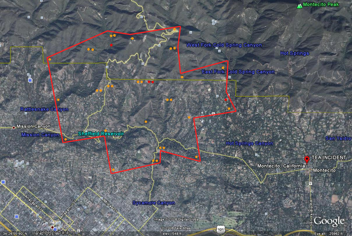
Tea Fire map/image from Google Fire Maps, 11/14/2008. Perimeter estimated from satellite-detected hot spots. Click on map for larger image.
***************
Situation as 11/14/2008 at 9:00 AM
Personnel: 1,141
Size: 1,000+ acres (update at noon — 2,500 acres)
Percent contained: 0%
An estimated 100 homes have been damaged or destroyed.
Mandatory evacuations in Montecito, Santa Barbara City and areas within Santa Barbara County.
***************
Situation as 11/13/2008 at 9:00 PM
Personnel: 100+
Size: 350 acres
Percent contained: 0%
Evacuations between Mountain Dr. and Hwy 192 between Cold Springs and Sycamore Canyon Rd.
Structures Threatened: 1,000 residences currently threatened in the area of Cold Springs and Mountain Dr. to Hwy 192, (East Valley Rd). Unknown number of homes destroyed.
Cooperating Agencies: CAL FIRE, Montecito, Santa Barbara County, STB, LPF, Edison, CHP, SBSO CDCR and CCC.
